Jaen
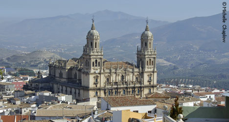
Jaen is a city that every lover of Andalucia should visit, enjoy and - if possible - spend a good deal of time getting to know. Not only does the city have an ancient and fascinating history, but the castle that towers over its winding streets offers some of the most quintessentially Andalusian views there are to be had. Stand at a prime lookout point at the top of the Santa Catalina castle and you will look down on a charming provincial capital that drapes over hills thus sending streets winding up and down steep inclines. From here you'll also enjoy the towns architecture and monuments. Fields and olive groves sweep out beyond the town and as you turn to the south and southeast, the spectacular peaks of the Sierra de Jaen and Jabalcuz rise and fall in the castle's backdrop. And if you find these views too breathtaking to enjoy for only a few moments, stop in at the Parador. There may be a castle room with a view just waiting for you.
Click here for Andalucia travel books

Jaen´s name comes from the Moorish word geen or jayyan, meaning stopping post on a caravan route. King Ferdinand III captured the city from Ibn-Nasr, who subsequently founded the Nasrid kingdom of Granada in 1246, and Jaen had a strategic position on the frontline between Christian Spain and Moorish Granada. It was used as the gateway for the armies in the Reconquest, and Ferdinand and Isabella launched their final assault on Boabdil´s Granada from here in 1492. Its Moorish old town, now the hillside barrio of La Magdalena, had many mosques, while the Moorish baths are the largest in Spain.
With just 116,012 inhabitants, Jaen is the least populated capital of all the provinces in Andalucia. In its old quarter, there exists some of what must have been a spectacular city. It is also home to the world's largest collection of Iberian objects. In the 1970s, a unique collection of sculptures dating from about 500 BC were discovered nearby and they are now proudly exhibited in the city's main museum. The city has a thriving university - one of the oldest in Spain. Market days are on Thursdays.
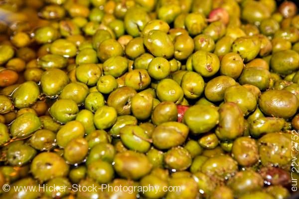 Jaen province has more olive trees than any other province in Spain, 40 million in fact - not surprising since its economy is based on olive oil. Liquid gold, as the locals call it, appears in all aspects of Jaen´s gastronomy, from tortas de matalahúva (aniseed cakes), ochíos (olive oil and aniseed bread rolls) and Christmas sweets, to nachas de Jaen, the local version of migas (breadcrumbs fried in olive oil); and pipirrana, a gazpacho-type salad of tomato and green pepper, onion and fish, with a dressing based on, you´ve guessed it, olive oil.
Jienense, as the locals are known, have a cuisine all their own – at least from their point of view. To the outsider, the menus of the day in Jaen will probably look very similar to those of any other town or village in Andalucia. To the insider, however – whether from Jaen or the rest of Andalucia – many dishes do offer a unique touch. Being an inland province, Jaen is better known for game and fish from local rivers – trout being a local favourite – than for the seafood you’ll find served just two hours away on the coast. You should, therefore, make a point of sampling the quail, deer or, of course, the trout. There is one local speciality, however, that does come from the sea and that is “Bacalao a la yema”, or cod a la egg yolk (most certainly tastier than it sounds). There is a fresh salad that is particularly tempting. If you can say “pipirrana”, then you can order yourself this wonderful plate of fresh chopped tomatoes served with a very special dressing made of local olive oil, green pepper, garlic and salt all pureed together. Very tasty, let me assure you. If you’re looking for an interesting beverage to either try or take home as a gift for friends, then look into a bottle of locally produced anis or resol liqueurs.
Fiestas in Jaen: Holy Week celebrations in Jaen are famous and people travel from all over Spain to watch the processions. Other important local fiestas include San Antón's Day in January when people gather round bonfires, eat and dance, Carnaval in February, Corpus Christi in June and finally Cruces de Mayo, a festival celebrated in many villages and towns throughout Jaen where people decorate the streets and patios with altars made of flowers to commemorate the Holy Cross.
Jaen’s Top 5:
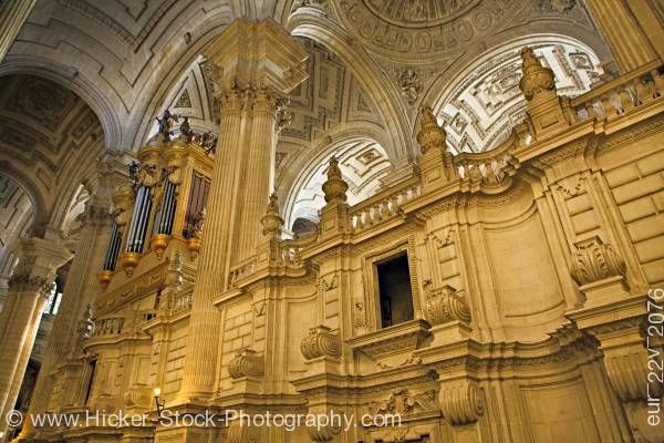
- Jaen Cathedral. Inside Jaen´s impressive Renaissance cathedral, behind the high altar, is a much-prized religious artfect: a cloth said to have been used by St Veronica to wipe Christ´s face as he carried the cross to Golgotha. The lienzo del Santo Rostro (cloth of the Holy Face) has an image of his countenance, allegedly, and is housed in its own chapel. The sacred cloth is removed from its reliquary on Friday mornings so that the faithful can kiss the glass box where it resides (the priest wipes the glass after each person). The image has been the subject of many Spanish paintings.
- Arab Baths . Although a palace was built over them in the 16th century, Jaen´s 11th-century hammam have survived another 400 years, and are now the largest baths open to the public in Spain. They were probably constructed on top of earlier (Roman) baths which used local hot springs - you can see Roman ruins through a glass walkway in the basement of the palace, on your way to visit the baths. The perfect horseshoe arches, star-shaped skylights and vaulted brick chambers (hot, warm and cold) were rediscovered in 1913, under the Palacio de Villardompardo, and their restoration project won the Europa Nostra (European Cultural Heritage) prize.
- Santa Catalina Castle. The Castle sits on the top of a hill overlooking the city.

Santa Catalina Castle - Museo Provincial de Bellas Artes. The Provincial Fine Arts Museum in Jaen has the World's best permanent exhibition of Iberian objects
- Royal Monastery of Santo Domingo. Used to be headquarters of the University of Jaen, this impressive monastery is located within the district of Magdalena.
http://www.euroresidentes.com/euroresiuk/guides-spain/guide-to-jaen.htm
http://www.hicker-stock-photography.com
Jerez

Jerez de la Frontera is a municipality in the province of Cádiz in the autonomous community of Andalucia, in southwestern Spain, situated midway between the sea and the mountains. As of 2010, the city, the largest in the province, had 208,896 inhabitants; it is the fifth largest in Andalucia. It has become the transportation and communications hub of the province, surpassing even Cádiz, the provincial capital, in economic activity. Jerez de la Frontera is also, in terms of land area, the largest municipality in the province, and its sprawling outlying areas are a fertile zone for agriculture.
There are signs of human presence in the area from the upper Neolithic, and Jerez has been inhabited by humans since at least the Copper or Neolithic Age, but the identity of the first natives remains unclear. The first major protohistoric settlement in the area (around the third millennium BC) is attributed to the Tartessians.

Later it was a Roman city, under the name of Asta Regia. After the fall of the Western Roman Empire, it was ruled by the Vandals and the Visigoths, until it was conquered by the Arabs in 711. In the 11th century it was shortly the seat of an independent taifa. Some years later it was united to Arcos by 'Abdun ibn Muhammad, who ruled both c. 1040-1053. In 1053 it was annexed to Seville. From 1145 to 1147 the region of Arcos and Jerez was briefly an emirate under dependency of Granada, led by Abu'l-Qasim Ahyal. Later the city was conquered by the Almohads. In the 12th and 13th centuries Jerez underwent a period of great development, building its defense system and setting the current street layout of the old town.
The Discovery of America and the conquest of Granada, in 1492, made Jerez one of the most prosperous cities of Andalucia through trade and its proximity to the ports of Seville and Cadiz. Despite the social, economic and political decadence that occurred in the seventeenth century, towards the end of the Habsburg rule, the city managed to maintain a reasonable pace of development, becoming world wide famous for its wine industry.
The Discovery of America and the conquest of Granada, in 1492, made Jerez one of the most prosperous cities of Andalucia through trade and its proximity to the ports of Seville and Cadiz. Despite the social, economic and political decadence that occurred in the seventeenth century, towards the end of the Habsburg rule, the city managed to maintain a reasonable pace of development, becoming world wide famous for its wine industry.
Jerez has always been an important trading city in which the most traditional products and ancient crafts can be found (barrel-making, wicker work, items related to wine or flamenco, saddling, etc.), with the many boutiques and companies where you can find the most exclusive of these products.

Jerez holds worldwide acclaim for its sherry and brandy production. The word Jerez is derived from Arabic and has now become synonymous with the English word ‘sherry’. The city is equally famous for its fine horses as well as Flamenco music and dance.
Jerez is also the site of Circuito de Jerez, formerly called the Circuito Permanente de Jerez, where the annual Motorcycle Grand Prix is contested. The race course is a prime destination for Formula One teams who wish to perform off-season testing; it also hosted the highly controversial 1997 European Grand Prix.
The town possesses a charming old town, casco antiguo, with beautiful palm lined squares. The 11th century Moorish fortress, or Alcazaba, has been partially restored. Of special interest is its church, originally built by the Arabs as a mosque. The Sacristy of the Cathedral del Salvador is home to a lovely painting by Zurbarán, The Sleeping Girl. Today the city of Jerez has a remarkably aristocratic air with wide streets, squares and magnificent rows of jacaranda trees during spring.
Jerez enjoys the very best of fresh local produce, to which is often added the world famous sherry, brandy and vinegar of Jerez. These are used as main ingredients in many recipes, thus allowing Jerez to provide a surprisingly varied cuisine of the highest quality. Shellfish and fish from the coast, meat and game from the hills, along with salads and traditional stews are staple dishes to be found in this region. They are often served "al Jerez" or "a la Jerezana", enhanced with Fino sherry, Amontillado, Oloroso or Pedro Ximénez, Brandy.
The restaurants in Jerez are generally of very high standard, having improved in quality over recent years. Many restaurants offer traditional Jerez cuisine of the highest level, prepared by professional chefs with long standing experience. The main restaurant area is located along the C/Constitorio and Plaza Vargas. In Spain it is unusual to eat an evening meal before 9.00pm. and Spaniards are often to seen arriving to eat as late as 11.00pm. Lunchtime too, begins later than in many other countries and diners can arrive as “late” as 3.30 or 4.00pm.
The restaurants in Jerez are generally of very high standard, having improved in quality over recent years. Many restaurants offer traditional Jerez cuisine of the highest level, prepared by professional chefs with long standing experience. The main restaurant area is located along the C/Constitorio and Plaza Vargas. In Spain it is unusual to eat an evening meal before 9.00pm. and Spaniards are often to seen arriving to eat as late as 11.00pm. Lunchtime too, begins later than in many other countries and diners can arrive as “late” as 3.30 or 4.00pm.

Jerez’s Top 5:
- The Cathedral of San Salvador is the cathedral church of the Roman Catholic Diocese of Asidonia-Jerez. It was declared Bien de Interés Cultural in 1931. Built in the 17th century, it is a mix of Gothic, Baroque and Neoclassicist style. It was elevated to the rank of cathedral in 1980. The church is on the central plan, a nave and four aisles of uneven height, supported external by normal and flying buttresses; in correspondence of the crossing of the transept is a dome. The interior houses a Virgin Mary by Francisco Zurbarán, and a late 15th century Gothic Crucifix (named Cristo de la Viga).
- The Charterhouse of Jerez is a monastery in Jerez de la Frontera. Its architecture is of a Late Gothic style, corresponding to the start of construction in the 15th century, with Baroque aspects dating from the 17th century. The building, completed in the 17th century, has been designated by the Spanish government as an Historic-Artistic Monument. The impulse behind the monastery dates back to Alvaro Obertos de Valeto, a knight of Genovese descent, appointed during the Reconquista by Alfonso X of Castile to defend the city shortly Alfonso had conquered it from Muslim rule in 1264. Lacking descendants, he left his fortune to establish a Carthusian monastery in the city. It was not until 1475 that this location near the Guadalete River was chosen, of special significance because in 1368 it has been the site of a victorious battle against invaders; the victory was attributed to intercession by the Virgin Mary, to whom a hermitage had been dedicated on the site.
- The Andalusian Centre of Flamenco is an institution in Jerez, founded in 1993 to safeguard and promote the values and standards of the traditional Andalusian art form known as flamenco. It is devoted to the investigation, recovery, and collection of flamenco-related historical documents, whether they are in audio, visual, or journalistic form. It also has a collection of flamenco artifacts, including musical instruments, costumes, promotional posters, sheet music, and postcards. The Centre operates a museum and library to help educate the public and serve as a resource for scholars.
- The Museo Arqueológico Municipal de Jerez de la Frontera is an archaeological museum on the Plaza del Mercado. The museum occupies an 18th-century building which was declared Bien de Interés Cultural in 1962. It was established in 1873 as the Municipal Archaeological Collection, merging collections donated by wealthy individuals, and based at the Old City Hall of Jerez. The museum opened to the public in 1935. The collection includes a Corinthian helmet, extremely rare in Spain, found near the city's Charterhouse by the river Guadalete. The collection also includes Roman ceramics and other items.
- The Alcazar of Jerez de la Frontera is a former Moorish fortress, now housing a park. It was declared Bien de Interés Cultural in 1931. A first fortress was probably built in the 11th century, when Jerez was part of the petty kingdom of the taifa of Arcos de la Frontera, on a site settled since prehistoric times in the south-eastern corner of the city. In the 12th century, a new structure was erected to be used as both residence and fortress by the Almohad rulers of southern Spain. Later, after the Reconquista of Andalusia, it was the seat of the first Christian mayors. The Alcazar contains a former mosque, the only remaining of the eighteen once present in the city. After the Christian conquest of the fortress in 1255, it was turned into a church dedicated to Virgin Mary by king Alfonso X of Castile. The minaret was turned into a bell tower.


References: http://www.andalucia.com/cities/jerez.htm

Kaliningrad

Originally named Königsberg in German, the town was founded in 1255 by the order of the Teutonic Knights in honour of the Czech king Přemysl Otakar II and was part of Prussia and then of Germany until 1945, but was largely destroyed during World War II. Its ruins were occupied by the Red Army in 1945 and its German population forced out. At the end of the war in 1945, the city became part of the Soviet Union.
 |
| Victory Square with the Cathedral of Christ The Saviour |
In 1957 an agreement was signed and later came into force which delimited the border between Poland and the Soviet Union.
Today, there is some debate about changing the name of the city back to "Königsberg" in the same way that several other Russian cities have reverted to their pre-Soviet names, e.g. Saint Petersburg and Tver, which were known in the Soviet era as Leningrad and Kalinin, respectively. "Kyonig" (Кёниг, a shortened form of "Königsberg" via Russian) is often used in advertisements for tourism companies in the region. Another possibility would be to give it a Russian name similar to other historic Slavic names, such as "Korolevets".

Kaliningrad Oblast used to be the most heavily militarized area of what is now the Russian Federation, and the density of military infrastructure was the highest in Europe. It was the headquarters of the former Soviet Baltic Military District. Kaliningrad also functions as the headquarters of the Russian Baltic Fleet, circled by Chernyakhovsk (air base), Donskoye (air base) and Kaliningrad Chkalovsk (naval air base).
During the Soviet era, access and control to the Baltic Sea was imperative because of Soviet perceptions that this meant that the hegemonic power had "influence on European and global affairs." Russia had replaced Sweden as the hegemon since the 18th century. At any point in time during the Soviet Era, there would be at least 100,000 troops stationed in Kaliningrad (though there are some estimates that run up to 300,000). Therefore, the population of the city was fluid and almost always temporary. Many military officers and their families would refer to the Kaliningrad Oblast as "the West". The Soviet Union also kept nuclear weapons for use in case a war were to occur.
 |
| Juditten Church |
Though it can’t compete with more glamorous counterparts such as Moscow, it’s much cheaper and offers a different, less-trodden experience at a time of rapid change. The local government is investing in environmental, active and cruise tourism and a growing number of English-speaking information centres. The city is also ‘rediscovering’ its historic, German roots in a bid to lure visitors.

Having fallen on hard times with the collapse of the Soviet Union, the exclave has undergone a recent recovery, having been given special economic status by President Putin. Many historic buildings were lost or heavily damaged during the Second World War. However, the Königsberg cathedral has been restored and other buildings are being overhauled. Soviet-era curiosities include ‘The Monster’, an unfinished and disused building from the 1960s.
And it’s certainly a sign of the times when the city’s Lenin statue is moved to make way for a new Russian Orthodox cathedral.
Kaliningrad has its own vodka and beer brands, Stari Konigsberg and Ostmark respectively. Since the early 1990s many new restaurants have opened in the city. These restaurants offer culinary specialities of former East Prussia, like Königsberger Klopse, but also many fish and salad dishes, Italian pizza and sushi, which is as popular in Kaliningrad as in the rest of Russia. Königsberger Fleck, a bovine tripe soup and yet another culinary specialty from former Königsberg, no longer belongs to the eating culture of Kaliningrad.
The people of Kaliningrad generally imported their respective culinary traditions to the region when they settled in the area after 1945. Borshch and okroshka may be served as in the rest of Russia. Many Italian and Asian restaurants (or fusions of both traditions) are in operation all over the city. Pizza and sushi are amongst the most popular dishes today.
The people of Kaliningrad generally imported their respective culinary traditions to the region when they settled in the area after 1945. Borshch and okroshka may be served as in the rest of Russia. Many Italian and Asian restaurants (or fusions of both traditions) are in operation all over the city. Pizza and sushi are amongst the most popular dishes today.

Kaliningrad’s Top 5:
- Kaliningrad Cathedral is a Brick Gothic style church on an island in the Pregel (Pregolya). The island was called Kneiphof in German times. The cathedral was built to replace a smaller cathedral, after Johann Clare, bishop of Sambia, insisted on the construction of a bigger building. The smaller cathedral, situated in Altstadt, was subsequently demolished and materials from it were used to build the new cathedral on Kneiphof. The construction of the cathedral on Kneiphof is considered to have begun in 1333. The soil on which the cathedral was built was marshy, and so hundreds of oak poles were put into the ground before the construction of the cathedral could begin. After the relatively short period of almost 50 years, the cathedral was largely completed by 1380. The cathedral originally had two spires. The spires (one north and one south) overlooked the entrance (west side) of the cathedral. But in 1544 the two spires were destroyed by fire. The south spire was rebuilt, but the north spire was replaced by a simple gable roof. In 1640 a clock was built underneath the rebuilt spire, and from 1650 the famous Wallenrodt Library, donated by Martin von Wallenrodt, was situated underneath the gable roof.
- Cathedral of Christ the Saviour. The Cathedral of Christ the Saviour is the largest church of Kaliningrad Oblast. It is the dominant building of the inner city and is situated near the central square, called Ploshchad Pobedy (Victory Square). The Russian Orthodox cathedral is 70 meters high. Its construction was completed on 10 September 2006. A small wooden chapel stands nearby. The church's architect is Oleg Kopylov.
- The Kaliningrad Amber Museum is a museum devoted to housing and displaying amber artworks. It is located in the city center, on the shore of Lake Verkhneye. The museum opened in 1979 and houses over 6,000 individual pieces. The museum occupies part of a reconstructed Teutonic castle, originally built by Karl Friedrich Emil zu Dohna-Schlobitten in the Napoleonic wars. Among the exhibits are the world's second-largest piece of amber and a 4-foot-tall (1.2 m) vase named The Abundance, as well as a collection of over 3,000 amber inclusions. Construction on the museum began in 1972.
- Juditten Church of St. Mary (Kirche von Juditten) is the oldest building in Kaliningrad . It was built in the late 13th century as a parish church of Juditten, a district now known as Mendeleyevo. The early Gothic church, first documented in 1288, was frescoed a century later. It had an organ from 1840, a Baroque altar, a cathedra from 1686, and a medieval statue of Madonna, which was reputed to work miracles. The local graveyard contained the tombs of Erhard Ernst von Röder (an 18th-century war minister), Hans von Lehwaldt (a Prussian Field Marshal), Stanislaus Cauer (a 20th-century sculptor). It was there that Johann Christoph Gottsched was baptised. The church remained in use until 1948 but quickly fell into ruin after the arrival of the Russians. It was reconsecrated in October 1985 as a Russian Orthodox church and was eventually restored to serve as the main church of St. Nicholas Orthodox Convent.
- The King's Gate is one of the former six gates that were built during the 19th century around Kaliningrad. The gate was designed by Friedrich August Stüler. The west facade has three sandstone statues, made by sculptor Wilhelm Stürmer: nine metres above the ground to the left the Bohemian king Ottokar II is depicted, who was Königsberg's namesake. Frederick I of Prussia, Prussia's first King, follows as the middle statue. To the right Duke Albert, Prussia's first duke and founder of the Albertina university, holds an eye over the city. Above the sculptures the coat of arms of Samland and Natangen are shown. The gate was damaged during the Second World War. Furthermore, as a first victory celebration, Soviet soldiers decapitated the statues. With the celebration of the city's 750 year existence in June 2005, the gate was renovated. Even a few months before the beginning of the festivities, the gate was still in a desolate condition. Within a few weeks, however, the gate was restored to its condition before the war. Fully restored statues replaced the decapitated ones on the gate with this renovation.

King's Gate


Kaunas

Kaunas is the second-largest city in Lithuania and has historically been a leading centre of Lithuanian economic, academic, and cultural life.
According to the archeological excavations, the most affluent collections of ceramics and other artefacts found at the confluence of the Nemunas and the Neris rivers are from the second and first millennium BC. During that time people settled in some territories of the present Kaunas.
A settlement had been established on the site of the current Kaunas old town at the confluence of two large rivers, at least by the 10th century AD. It is believed the town was founded in 1030, but it is first mentioned in written sources in 1361. In the 13th century, a stone wall was built as protection from constant raids by the Teutonic Knights. In 1362, the town was captured by the Teutonic Knights, who destroyed the Kaunas Castle. The commander of the Kaunas castle garrison Vaidotas with 36 men tried to break through, but was taken prisoner. It was one of the largest and important military victories of the Teutonic Knights in the 14th century against Lithuania. The Kaunas castle was rebuilt at the beginning of the 15th century.

In 1665, the Russian army attacked the city several times, and in 1701 the city was occupied by the Swedish army. The Black Death struck the area in 1657 and 1708, and fires destroyed parts of the city in 1731 and 1732.
After the final partition of the Polish–Lithuanian state in 1795, the city was taken over by the Russian Empire and became a part of Vilna Governorate. During the French invasion of Russia in 1812, the Grand Army of Napoleon passed through Kaunas twice, devastating the city both times.
After the Partitions, Kaunas was one of the centres of the November Uprising (1830–1831) and the January Uprising (1863–1864). To suppress the local population, the Russian authorities subsequently established the Kaunas Prison and placed a huge military garrison in the town. The Russian military fortifications from that time still survive throughout the town.
Prior to the Second World War, Kaunas, like many other cities in eastern Europe, had a significant Jewish population. According to the Russian census of 1897, Jews numbered 25,500, 35.3% of the total of 73,500.The population was also 25.8% Russian, 22.7% Polish, 6.6% Lithuanian.

After Vilnius was occupied by the Russian Bolsheviks in 1919, the government of the Republic of Lithuania established its main base here. Later, when the capital Vilnius was forcibly annexed by Poland, Kaunas became the temporary capital of Lithuania, a position it held until 28 October 1939, when the Red Army handed Vilnius back to Lithuania. The Constituent Assembly of Lithuania first met in Kaunas on 15 May 1920. It passed some important laws, particularly on land reform, on the national currency, and adopted a new constitution. The military coup d'état took place in Kaunas on 17 December 1926. It was largely organized by the military and resulted in the replacement of the democratically elected government with a conservative authoritarian government led by Antanas Smetona. The last meeting of the Lithuanian government was held just before midnight in Kaunas on 14 June 1940. During it, the ultimatum presented by the Soviet Union, was debated.
Between the World Wars industry prospered in Kaunas; it was then the largest city in Lithuania. Under direction of the mayor Jonas Vileišis (1921–1931) Kaunas grew rapidly and was extensively modernised. A water and waste water system, costing more than 15 million Lithuanian litas, was put in place, the city expanded from 18 square kilometers to 40, more than 2,500 buildings were built, plus three modern bridges over the Neris and Nemunas rivers. All the city's streets were paved, horse-drawn transportation was replaced with modern bus lines, new suburbs were planned and built (Žaliakalnis neighborhood in particular), and new parks and squares were established. The foundations for a social security system were laid, three new schools were built, and new public libraries, including the Vincas Kudirka library, were established. J. Vileišis maintained many contacts in other European cities, and as a result Kaunas was an active participant in European urban life.

After the German invasion of USSR on 22 June, the June Uprising against the retreating Red Army began in Kaunas and a short-lived period of independence was proclaimed in Kaunas on 23 June 1941. During the battles with the Red Army, Lithuanian rebels secured government offices, police stations, shops, warehouses, and attempted to re-establish order in the city. On 25 June the main German forces marched into the city without opposition and almost in parade fashion. The Nazi Germans did not recognize the new provisional government, but they did not take any actions to dissolve it until the establishment of a German civil administration on 17 July. The government's powers were taken over by the new occupants. Nazi Germany established the Reichskommissariat Ostland in the Baltic States and much of Belarus, and the administrative centre for Lithuania (Generalbezirk Litauen) was in Kaunas ruled by Generalkommissar Adrian von Renteln.
Beginning in 1944, the Red Army began offensives that eventually took back all three of the Baltic states. Kaunas again became the major centre of resistance against the Soviet regime. From the very start of the Lithuanian partisans war, the most important partisan districts were based around Kaunas. Although guerrilla warfare ended at the time of 1953, Lithuanian opposition to Soviet rule did not. In 1956 people in the Kaunas region supported the uprising in Hungary by rioting. On All Souls' Day in 1956, the first public anti-Soviet protest rally took place in Kaunas: citizens burned candles in the Kaunas military cemetery and sang national songs, resulting in clashes with the Militsiya.

On 10 June 1988, the initiating group of the Kaunas movement of Sąjūdis was formed. On 9 October 1988, the Flag of Lithuania was raised above the tower of the Military Museum. Kaunas, along with Vilnius, became the scene of nearly constant demonstrations as the Lithuanians, embarked on a process of self-discovery. The bodies of Lithuanians who died in Siberian exile were brought back to their homeland for reburial, and the anniversaries of deportations as well as the important dates in Lithuanian history began to be noted with speeches and demonstrations. On 16 February 1989 Cardinal Vincentas Sladkevičius, for the first time, called for the independence of Lithuania in his sermon at the Kaunas Cathedral. After the services, 200,000 persons gathered in the centre of Kaunas to participate in the dedication of a new monument to freedom to replace the monument that had been torn down by the Soviet authorities after the World War II.
After the proclamation of Lithuanian independence in 1990, Soviet attempts to suppress the rebellion focused on the Sitkūnai Radio Station. They were defended by the citizenry of Kaunas. Pope John Paul II made the Holy Mass for the faithful of the Archdiocese of Kaunas at the Kaunas Cathedral Basilica and held the meeting with the young people of Lithuania at S. Darius and S. Girėnas Stadium, during his visit to Lithuania in 1993.
Since the restoration of independence, improving substantially air and land transport links with Western Europe have made Kaunas easily accessible to foreign tourists.
.jpg)
Kaunas’ Top 5:
- Kaunas Cathedral Basilica The exact date when the first Gothic style church dedicated to apostles Saint Peter and Saint Paul, was built is unknown, but it was first mentioned in written sources in 1413. The construction works were concluded only in 1624. The church greatly suffered from wars in 1655 and was rebuilt in 1671 and gained some Renaissance features. Only one of the towers was rebuilt after the fire of the roof in 1732. As a part of renovation, the internal decorations were funded by the King Stanisław August Poniatowski in 1771. The main altar, a lectern and a choir were installed by Tomasz Podhajski in 1775. The present day shape of the building is from 1800 renovation. Тhе bishop of Samogitia, historian and one of the best known Lithuanian writers of the 19th century Motiejus Valančius was interred in a crypt of the church in 1875. The church was promoted to cathedral status by Pope Leo XIII in 1895. It received the Basilica title in 1926, when the Diocese of Samogitia was reorganized into the Metropolitan Archdiocese of Kaunas by Pope Pius XI. The cathedral is the largest Gothic church in Lithuania.
- The Town Hall of Kaunas stands in the middle of the Town Hall Square at the heart of the Old Town. The structure dates from the 16th century. It houses a Museum of Ceramics. The construction of Kaunas town hall started in 1542. At first it was a one-storey building with not daubed facade and vaulting cellars. In the 16th century the first floor was build and the eight storey tower was built in the east of the building. The ground floor was adjusted for trading and prison guards, the first floor - for trial, magistrate, treasure, archive and office. Cellars were used to store the goods. The cellars of the tower were used as a prison.
- House of Perkūnas is one of the most original and archaic Gothic secular buildings, located in the Old Town. Originally built by Hanseatic merchants and served as their office from 1440 till 1532, it was sold in the 16th century to the Jesuits who had established a chapel there in 1643. The Jesuits have also completed the Church of St. Francis Xavier at the Town Hall Square in 1722. The ruined house was rebuilt in the 19th century and served as a school and theatre, which was attended by Polish-Lithuanian poet Adam Mickiewicz. At the end of the 19th Century it was renamed "House of Perkūnas", when a figure, interpreted by the romantic historians of that time as an idol of the Baltic pagan god of thunder and the sky Perkūnas was found in one of its walls. Today, the house of Perkūnas once again belongs to the Jesuits and houses a museum of Adam Mickiewicz.
- The Vytautas the Great War Museum It was opened on 16 February 1936 and named after Vytautas the Great, Grand Duke of Lithuania. The museum displays historical artefacts pertaining to Lithuania and Kaunas from prehistoric times to the present day, including a large collection of historical weapons. There are expositions dedicated to the military skills of the Grand Duchy of Lithuania, Vytautas the Great Chapel, collections of weapons, firearms, ammunition, army uniforms of various states, defense of the Kaunas Fortress in 1915, and others. The airplane Lituanica, on which Steponas Darius and Stasys Girėnas flew across the Atlantic Ocean in 1933, is on display and remains a popular exhibition.
- Kaunas Castle Archeological evidence suggests that it was originally built during the mid-14th century, in the Gothic style. Its site is strategic – a rise on the banks of the Nemunas River near its confluence with the Neris River. At the beginning of the 21st century, about one-third of the castle was still standing. The precise construction date of the first Kaunas Castle is unknown. Archeological data suggests that a stone castle was built on the site during the middle of the 14th century. Situated on an elevated bank near the river junction about 100 kilometers (62 mi) from the capital city of Vilnius, it served as a strategic outpost and guarded nearby cities as well as trade routes. Today the round tower of Kaunas Castle houses an art gallery. The castle is open to tourism, and hosts occasional festivals. Major reconstruction work started in 2010.


Kharkiv

Kharkiv is the second-largest city of Ukraine. Located in the north-east of the country, it is the largest city of the Slobozhanshchyna historical region.
Archeological evidence discovered in the area of present-day Kharkiv indicates that a local population has existed in that area since the second millennium BC. Cultural artifacts date back to the Bronze Age, as well as those of later Scythian and Sarmatian settlers. There is also evidence that the Chernyakhov culture flourished in the area from the second to the sixth century.

The city was founded by re-settlers who were running away from the war that engulfed Right-bank Ukraine in 1654. The group of people came onto the banks of Lopan and Kharkiv rivers where stood an abandoned settlement. Some sources indicate that the city was founded by the eponymous, near-legendary character, called Kharko (a diminutive form of the name Kharyton). At first the settlement was a self-governed under the jurisdiction of a voivode from Chuhuiv that is located 40 kilometres (25 mi) to the east. The first appointed voivode from Moscow was Voyin Selifontov in 1656 who started to build a local ostrog (fort). At that time the population of Khakriv was just over 1,000 half of which were local cossacks, while Selifontov brought along a Moscow garrison of another 70 servicemen. The first Kharkiv voivode was replaced in two years after constantly complaining that locals refuse to cooperate in building of the fort. Kharkiv also became the centre of the local Sloboda cossack regiment as the area surrounding the Belgorod fortress was being heavily militarized. With the resettlement of the area Ukrainians it became to be known as Sloboda Ukraine, most of which was included under the jurisdiction of the Razryad Prikaz (Military Appointment) headed by a district official from Belgorod. By 1657 the Kharkiv settlement already had a fortress with underground passageways.
In the course of the administrative reform carried out in 1708 by Peter the Great, the area was included into Kiev Governorate. Kharkov is specifically mentioned as one of the towns making a part of the governorate. In 1727, Belgorod Governorate was split off, and Kharkiv moved to Belgoro Governorate. It was the center of a separate administrative unit, Kharkiv Kazak Sloboda Regiment. The regiment at some point was detached from Belgorod Governorate, then attached to it again, until in 1765, Slobodsko-Ukrainian Governorate was established with the seat in Kharkiv.

Prior to the formation of the Soviet Union, Bolsheviks established Kharkiv as the capital of the Ukrainian Socialist Soviet Republic (from 1919–1934) in opposition to the Ukrainian People's Republicwith its capital of Kiev.
As the country's capital, it underwent intense expansion with the construction of buildings to house the newly established Ukrainian Soviet government and administration.
In 1928, the SVU (Union for the Freedom of Ukraine) process was initiated and court sessions were staged in the Kharkiv Opera (now the Philharmonia) building. Hundreds of Ukrainian intellectuals were arrested and deported.
In the early 1930s, the Holodomor famine drove many people off the land into the cities, and to Kharkiv in particular, in search of food. Many people died and were secretly buried in mass graves in the cemeteries surrounding the city.
In 1934 hundreds of Ukrainian writers, intellectuals and cultural workers were arrested and executed in the attempt to eradicate all vestiges of Ukrainian nationalism in Art. The purges continued into 1938. Blind Ukrainian street musicians were also gathered in Kharkiv and murdered by the NKVD. In January 1935 the capital of the Ukrainian SSR was moved from Kharkiv to Kiev.

During April and May 1940 about 3,800 Polish prisoners of Starobelsk camp were executed in the Kharkiv NKVD building, later secretly buried on the grounds of an NKVD pansionat in Pyatykhatky forest (part of the Katyn massacre) on the outskirts of Kharkiv. The site also contains the numerous bodies of Ukrainian cultural workers who were arrested and shot in the 1937–38 Stalinist purges.

Kharkiv’s Top 5:
- The Annunciation Cathedral is the main Orthodox church of Kharkiv. The pentacupolar Neo-Byzantine structure with a distinctive 80-meter-tall bell tower was completed on October 2, 1888, from designs by a local architect, Mikhail Lovtsov. The church was baptized in 1901, while the first church of Annunciation (built in 17th century), located next to it was dismantled. The candy-striped cathedral supplanted the older Assumption Cathedral as the main church of Kharkiv and was one of the largest and tallest churches of the Russian Empire. The church was frescoed in a style derived from St Vladimir's Cathedral in Kiev. On July 3, 1914 the temple became recognized as the city's cathedral. The cathedral was closed to worshippers in 1930, but it was reopened during the German occupation in 1943. During that time the space in the temple initially was assigned to a cultural lyceum, while there are some evidences that it was used as a warehouse. During WWII it was a temple of the Ukrainian Autocephalous Orthodox Church. Since 1946 the cathedral is the seat of the Kharkiv and Bohodukhiv eparchy of the Ukrainian Orthodox Church (Moscow Patriarchate), while the bishop residence has stayed in the Saint-Pokrov Monastery. The Ecumenical Patriarch Athanasius III Patelaros and several saintly bishops are buried in the cathedral.
- The Kharkiv Choral Synagogue is the largest synagogue in the country, and a building of architectural significance. Construction of the synagogue began in 1909, with architects submitting design proposals as part of contest. St. Petersburg architect Yakov Gevirts submitted the winning design and construction was completed in 1913 at a cost of 150,000 rubles. In 1923, the synagogue was closed, nationalized by the government, and used by a Jewish worker's club, part of the Comintern. It then served a variety of uses including housing a club, cinema and a sport complex and was not used as a place of worship until 1990.
- The Shevchenko Gardens is the oldest green area in the city centre. It was planted as far back as 1804. The gardens central path is a beautiful chestnut-tree alley leading from the Taras Shevchenko Monument to the University building. The gardens area of 25 hectares has over 15,000 trees and bushes of more than 100 varieties. It also has gigantic oaks, which are over 200 years old. One of these grows close to the monument to the great Kobzar (Bard). The gardens are being expanded and improved every year. After the war, their western slope was reconstructed with a water cascade and stairs leading down to the Klochkovska Street. A color and music fountain is located in the center of the gardens.
- The Kharkiv State Academic Opera and Ballet Theatre named after M.Lysenko is the first academic theatre in Ukraine. It presents operas in Ukrainian, Russian, French and Italian. This leading Ukrainian theatre was opened in 1925 by putting on the stage opera "Sorochynska yarmarka" ("Sorochyntsy Fair") of Russian composer Modest Mussorgsky. From 1991 the theatre works in the new building which is built in postmodern style and is located at Sumskaya Str. 25/27. The repertoire includes around 50 operas and ballets, the majority of which are Ukrainian and Russian but there are also Italian ones.
- The Assumption or Dormition Cathedral was the main Orthodox church of Kharkiv until the construction of the Annunciation Cathedral in 1901. The cathedral stands on the University Hill by the bank of the Lopan River and dominates the entire downtown. The Neoclassical cathedral bell tower, built in the 1820s and 1830s to a height of 90 meters, remained the tallest building in the city until the 21st century. The original Dormition Church was built in the Kharkov Fortress in the 1680s. It was completely rebuilt after a fire to a Late Baroque design loosely based on St Clement's Church, Moscow. The cathedral was consecrated in 1780 in the presence of Ukraine's governor, Pyotr Rumyantsev. The church boasted a gilded icon screen, carved from limewood to Rastrelli's Rococo design. The free-standing Alexander Bell Tower was built in the aftermath of Napoleon's expulsion from Russia "to express the people's gratitude to Alexander I". It used to be the second tallest building in Ukraine after the Great Lavra Bell Tower. The seat of the local bishop was moved from the older Intercession Cathedral to the Dormition Church in 1846. A large French clock was installed in the bell tower in 1856.


Kiev
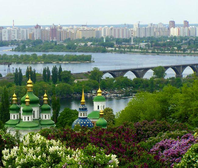
Kiev or Kyiv is one of the most beautiful cities in Europe. Founded 1500 years ago, Kiev is the bustling capital of newly independent Ukraine. This city, with a population of 3 million people, is distinguished for its rich architecture and cultural life. The city boasts two stunning UNESCO World Heritage Sites, and is fast becoming a major cultural destination for Europe, especially for those interested in travelling ‘off the beaten track.’
Click here for Ukraine Travel Books
 |
Throughout the city, museums, theatres, opera houses, historical buildings and gardens are to be found, laid out on either side of the picturesque Dnieper River. The western bank is home to the older part of the city and was, pre-urbanisation, characterised by its forested hills, as well as steep ravines and winding rivers, which serve as ice-rinks in winter. Watched over by a statue of the historic protector of Kiev, Michael Archangel, the city also boasts a successful blend of the old and the new. Modern buildings nestle against historical gems and cultural wonders rub shoulders with trendy, buzzing nightclubs, bars and restaurants.

With a skyline defined by the golden domes of numerous churches and monasteries, the streets of Kiev, one of Europe’s oldest cities, exude a sense of permanence. It has stood here for centuries, its fortunes rising and falling, but today Kiev exists as a striking modern city which preserves its past, to the delight and more interest of visitors. On holiday in Kiev visitors cannot ignore history, but also revel in the many attractions of this cultural city of charm.
Kiev is a city of invaluable historical and cultural monuments, a city of great events and outstanding people. Everyone will find there something especially interesting for himself.
The art and architecture of Kiev are considered world treasures. Many famous artists, poets and writers estimated the unique beauty of this city. The most renowned landmarks include: Cathedral of St. Sophia with outstanding mosaics and frescoes dating back to the 11th century; Kievo-Percherskaya Lavra featuring several monasteries and cathedrals; Golden Gate of Kiev, which date back to 1037; Ukrainian Baroque Church of St. Andrew; the magnificent 19th-century Cathedral of St. Vladimir; and many other attractions. Kiev is often referred to as "the mother of all cities" by Russians and Ukrainians. It is one of the oldest towns in Europe. In the historical center of Kiev you can feel the spirit of the past everywhere.
Kiev is distinguished for its rich cultural life. Theater lovers will find many theatres offering various theatrical programs. Most performances are held in Ukrainian or Russian. The recently renovated Kiev Opera House presents very good opera as well as a broad repertoire of ballets. Ivan Franko Theater is a center of Ukrainian drama, comedy, and musicals. A lot of various exhibitions are carried out in the city's numerous museums and art galleries.Take a walk through the ancient streets of this scenic city, feel its unique beauty and the spirit of its past. For sure your stay in Kiev will become one of your most memorable experiences.

A wide variety of farm produce is available in many of Kiev's farmer's markets with the Besarabsky Market located in the very centre of the city being most famous. Each residential region has its own market, or rynok. Here one will find table after table of individuals hawking everything imaginable: vegetables, fresh and smoked meats, fish, cheese, honey, dairy products such as milk and home-made smetana (sour cream), caviar, cut flowers, housewares, tools and hardware, and clothing. Each of the markets has its own unique mix of products with some markets devoted solely to specific wares such as automobiles, car parts, pets, clothing, flowers, and other things.
http://www.kiev.info/
Kiev is a city of invaluable historical and cultural monuments, a city of great events and outstanding people. Everyone will find there something especially interesting for himself.
The art and architecture of Kiev are considered world treasures. Many famous artists, poets and writers estimated the unique beauty of this city. The most renowned landmarks include: Cathedral of St. Sophia with outstanding mosaics and frescoes dating back to the 11th century; Kievo-Percherskaya Lavra featuring several monasteries and cathedrals; Golden Gate of Kiev, which date back to 1037; Ukrainian Baroque Church of St. Andrew; the magnificent 19th-century Cathedral of St. Vladimir; and many other attractions. Kiev is often referred to as "the mother of all cities" by Russians and Ukrainians. It is one of the oldest towns in Europe. In the historical center of Kiev you can feel the spirit of the past everywhere.
Kiev is distinguished for its rich cultural life. Theater lovers will find many theatres offering various theatrical programs. Most performances are held in Ukrainian or Russian. The recently renovated Kiev Opera House presents very good opera as well as a broad repertoire of ballets. Ivan Franko Theater is a center of Ukrainian drama, comedy, and musicals. A lot of various exhibitions are carried out in the city's numerous museums and art galleries.Take a walk through the ancient streets of this scenic city, feel its unique beauty and the spirit of its past. For sure your stay in Kiev will become one of your most memorable experiences.

A wide variety of farm produce is available in many of Kiev's farmer's markets with the Besarabsky Market located in the very centre of the city being most famous. Each residential region has its own market, or rynok. Here one will find table after table of individuals hawking everything imaginable: vegetables, fresh and smoked meats, fish, cheese, honey, dairy products such as milk and home-made smetana (sour cream), caviar, cut flowers, housewares, tools and hardware, and clothing. Each of the markets has its own unique mix of products with some markets devoted solely to specific wares such as automobiles, car parts, pets, clothing, flowers, and other things.
Kiev’s Top 5:
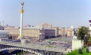 |
| Independence Square |
- St. Sophia's Cathedral. one of the city's best known landmarks and the first Ukrainian patrimony to be inscribed on the World Heritage List along with the Kiev Cave Monastery complex. The cathedral is famous for its mosaics and frescos by Byzantine masters that date back to the 11th century. Marvelous frescos decorate walls, pillars and vaults. Inside, the central part of the cathedral is decorated with large mosaic depicting praying Virgin Mary.
- Kiev Fortress. Kiev fortress is the 19th century fortification buildings situated in Ukrainian capital Kiev, that once belonged to western Russian fortresses. These structures (once a united complex) were built in the Pechersk and neighbourhoods by the Russian army. Now some of the buildings are restored and turned into museum called the Kiev Fortress, while others are in use of various military and commercial installations.
- Independence Square. The central square of Kiev is located on Khreschatyk Street. The square has been known under many different names, but it became known simply as the Maidan due to the political events that took place there in 2004 after the Ukrainian accession to independence. The square becomes a large outdoor party place at night during summer months, with thousands of people having a good time in nearby restaurants, clubs and outdoor cafes. The central streets are closed for auto traffic on weekends and holidays.
- Kievo-Pecherskaya Lavra. On the high hills of the right bank of the Dnepr River magnificent Kievo-Pecherskaya Lavra topped with gilded domes is situated. According to the legend, Apostle Andrew, while preaching the Word of God in the Scythian Land, blessed the hilly bank of the Dnepr River and said to his disciples: "On these hills great city and many churches in glorification of Holy God will be".
- Golden Gate. The Golden Gates of Kiev is a major landmark of the Ancient Kiev and historic gateway in the ancient city fortress. Currently it serves as a museum and can be found on the corner of Volodymyr street and Yaroslaviv Val Street (Yaroslav's Moat). The gateway was one of three constructed by Yaroslav the Wise, Prince of Kiev, in the mid-11th century. It was reputedly modelled on the Golden Gate of Constantinople, from which it took its name.

Golden Gate

http://www.kiev.info/
Koblenz

Koblenz, also spelled Coblenz or Coblence, is a German city situated on both banks of the Rhine at its confluence with the Moselle, where the Deutsches Eck (German Corner) and its monument (Emperor William I on horseback) are situated.
Around 1000 BC, early fortifications were erected on the Festung Ehrenbreitstein hill on the opposite side of the Moselle. In 55 BC, Roman troops commanded by Julius Caesar reached the Rhine and built a bridge between Koblenz and Andernach. About 9 BC, the "Castellum apud Confluentes", was one of the military posts established by Drusus.
Remains of a large bridge built in 49 AD by the Romans are still visible. The Romans built two castles as protection for the bridge, one in 9 AD and another in the 2nd century, the latter being destroyed by the Franks in 259. North of Koblenz was a temple of Mercury and Rosmerta (a Gallo-Roman deity), which remained in use up to the 5th century.

With the fall of the Western Roman Empire, the city was conquered by the Franks and became a royal seat. After the division of Charlemagne's empire, it was included in the lands of his son Louis the Pious (814). In 837, it was assigned to Charles the Bald, and a few years later it was here that Carolingian heirs discussed what was to become the Treaty of Verdun (843), by which the city became part of Lotharingia under Lothair I. In 860 and 922, Koblenz was the scene of ecclesiastical synods. At the first synod, held in the Liebfrauenkirche, the reconciliation of Louis the German with his half-brother Charles the Bald took place. The town was sacked and destroyed by the Normans in 882. In 925, it became part of the eastern German Kingdom, later the Holy Roman Empire.
In 1018, the city was given by the emperor Henry II to the archbishop and prince elector of Trier after receiving a charter. It remained in the possession of his successors until the end of the 18th century, having been their main residence since the 17th century. Emperor Conrad II was elected here in 1138. In 1198, the battle between Philip of Swabia and Otto IV took place nearby. In 1216, prince-bishop Theoderich von Wied donated part of the lands of the basilica and the hospital to the Teutonic Knights, which later became the Deutsches Eck.
.jpg)
In 1249–1254, Koblenz was given new walls by Archbishop Arnold II of Isenburg; and it was partly to overawe the turbulent townsmen that successive archbishops built and strengthened the fortress of Ehrenbreitstein that still dominates the city.
The city was a member of the league of the Rhenish cities which rose in the 13th century. The Teutonic Knights founded the Bailiwick of Koblenz in or around 1231. Koblenz attained great prosperity and it continued to advance until the disaster of the Thirty Years' War brought about a rapid decline. After Philip Christopher, elector of Trier, surrendered Ehrenbreitstein to the French, the town received an imperial garrison in 1632. However, this force was soon expelled by the Swedes, who in their turn handed the city over again to the French. Imperial forces finally succeeded in retaking it by storm in 1636.
In 1688, Koblenz was besieged by the French under Marshal de Boufflers, but they only succeeded in bombing the Old City (Altstadt) into ruins, destroying among other buildings the Old Merchants' Hall (Kaufhaus), which was restored in its present form in 1725. The city was the residence of the archbishop-electors of Trier from 1690 to 1801.
In 1688, Koblenz was besieged by the French under Marshal de Boufflers, but they only succeeded in bombing the Old City (Altstadt) into ruins, destroying among other buildings the Old Merchants' Hall (Kaufhaus), which was restored in its present form in 1725. The city was the residence of the archbishop-electors of Trier from 1690 to 1801.
 |
| Electoral Palace |
In 1786, the last archbishop-elector of Trier, Clemens Wenceslaus of Saxony, greatly assisted the extension and improvement of the city, turning the Ehrenbreitstein into a magnificent baroque palace. After the fall of the Bastille in 1789, the city became, through the invitation of the archbishop-elector's chief minister, Ferdinand Freiherr von Duminique, one of the principal rendezvous points for French émigrés. The archbishop-elector approved of this because he was the uncle of the persecuted king of France, Louis XVI. Among the many royalist French refugees who flooded into the city were Louis XVI's two younger brothers, the Comte de Provence and the Comte d'Artois. In addition, Louis XVI's cousin, the Prince de Condé, arrived and formed an army of young aristocrats willing to fight the French Revolution and restore the Ancien Régime. The Army of Condé joined with an allied army of Prussian and Austrian soldiers led by Duke of Brunswick in an unsuccessful invasion of France in 1792. This drew down the wrath of the First French Republic on the archbishop-elector; in 1794, Coblenz was taken by the French Revolutionary army under Marceau (who was killed during the siege), and, after the signing of the Treaty of Lunéville (1801) it was made the capital of the new French départment of Rhin-et-Moselle. In 1814, it was occupied by the Russians. The Congress of Vienna assigned the city to Prussia, and in 1822, it was made the seat of government for the Prussian Rhine Province.

After World War I, France occupied the area once again. In retaliation against the French, the German populace of the city has insisted on using the more German spelling of Koblenz since 1926. During World War II it was the location of the command of Army Group B and like many other German cities, it was heavily bombed and rebuilt afterwards. Between 1947 and 1950, it served as the seat of government of Rhineland-Palatinate.
The Rhine Gorge was declared a World Heritage Site in 2002, with Koblenz marking the northern end.
The Romans brought the first wines to the region. Since then this old tradition has been maintained and has manifested into the wine town of Koblenz and about half a million wines. The wine growers can prove their fantastic talents in the Rhine and on the Moselle presenting the best of these two famous wine cultivation areas.

The number of taverns, pubs and cafés has drastically increased in the old town and in the areas around Jesuit Square and Görres Square in the past few years. In addition to a large selection of venues with international food, the guest can also expect a large range of experience-oriented gastronomy with music and dance events, exhibitions and performances.
 The shopping experience is extended throughout the year by numerous events in cooperation with the “Alle lieben Koblenz e.V.“ society, the “Schängelmarkt GmbH“ and the owner-operated Koblenz tourism board. Examples of this are the Sunday open days in March (Koblenz is blooming), September (Schängel Market) and October (Koblenz clinkers) and the Christmas market at the end of November.
The Oberzentrum Koblenz offers varied shopping opportunities for residents, guests and the neighbouring towns and regions. Shoppers at the centre appreciate the wide range of goods and services on offer along with the overall shopping experience. The balanced mixture of specialist stores which have been in the old town, Schlossstraße and Oberer Löhr for years and the attractive department stores in Löhrstraße and in the Löhr-Center promises amusement and variety.
 The shopping experience is extended throughout the year by numerous events in cooperation with the “Alle lieben Koblenz e.V.“ society, the “Schängelmarkt GmbH“ and the owner-operated Koblenz tourism board. Examples of this are the Sunday open days in March (Koblenz is blooming), September (Schängel Market) and October (Koblenz clinkers) and the Christmas market at the end of November.
The charm of the shopping town of Koblenz can be particularly experienced in the attractive pedestrian area in the historic old town near to the banks of the Moselle. Exclusive stores in narrow streets, little boutiques in romantic squares and cosy cafés with the backdrop of old patrician houses offer pure shopping experiences. Those who want to take time out from shopping will quickly find the way to the banks of the Rhine and Moselle or the German Corner.
Koblenz’s Top 5:
- The Basilica of St. Castor is the oldest church in Koblenz. It is located near Deutsches Eck at the confluence of the Rhine and the Moselle. A fountain called Kastorbrunnen("Castor well") was built in front of the basilica during Napoleon’s invasion of Russia in 1812.Pope John Paul II raised St. Castor to a basilica minor on 30 July 1991. This church is worth seeing for the historical events that have occurred in it, its extensive Romanesque construction and its largely traditional furnishings. Since 2002, the Basilica of St. Castor has been part of the UNESCO World Heritage cultural landscape of the Upper Middle Rhine Valley. In addition, it is a cultural property protected under the Hague Convention. The church of St. Castor was built between 817 and 836 by Hetto, the Archbishop of Trier with the support of Emperor Louis the Pious, just outside the city of Confluentes (the city founded by the Romans in the area) and dedicated on 12 November 836. As Koblenz had a Frankish royal court, Louis was in charge of the construction of the church and it was built as a Carolingian proprietary church. However, Louis did not come to Koblenz until after the consecration of the church. This points to the importance of the Archbishop in the building of the church, especially as the church was until the 13th century outside the city of Koblenz.
- The Electoral Palace (German: Kurfürstliche Schloss) was the residence of the last Archbishop and Elector of Trier, Clemens Wenceslaus of Saxony, who commissioned the building of the castle by the end of the 18th Century. In the mid-19th Century, the Prussian Crown Prince (later Emperor William I) resided in the castle for a number of years as a Rhenish-Westphalian military governor. Today it is the location of various federal agencies. One of the most important castles of the French early classicism in southwestern Germany, and one of the last residence palaces built before the French Revolution in Germany. Since 2002, the Electoral Palace is part of the World Heritage Upper Middle Rhine Valley, acknowledged by UNESCO.
- William I monument The Teutonic Knights were given an area for their Deutschherrenhaus Balley right at the confluence of the Rhine and Mosel, which became known as German Corner (Deutsches Eck).In 1897, a monument to German Emperor William I of Germany, mounted on a 14 meter high horse, was inaugurated there by his grandson William II. The architect was Bruno Schmitz, who was responsible for a number of nationalistic German monuments and memorials. The German Corner is since associated with this monument, the (re) foundation of the German Empire and the German refusal of any French claims to the area, as described in the song "Die Wacht am Rhein" together with the "Wacht am Rhein" called "Niederwalddenkmal" some 30 km upstream.
- Stolzenfels Castle Finished in 1259, Stolzenfels was used to protect the toll station at the Rhine, where the ships, back then were the main transport for goods, had to stop and pay toll. Over the years it was extended several times, occupied by French and Swedish troops in the Thirty Years' War and finally, in 1689, destroyed by the French during the Nine Years' War. For 150 years the ruins decayed, until in 1815 they were given as a present to Frederick William IV of Prussia by the city of Koblenz. Following the romantic traditions, the prince started to completely rebuild the castle after 1826 as a summer residence. Supported by famous neoclassic architect Karl Friedrich Schinkel, the castle was completely remodeled in the then fashionable neo-Gothic style, aiming to create a romantic place representing the idea of medieval knighthood - the architects even created a tournament site.
- Ehrenbreitstein Fortress is a fortress on the mountain of the same name on the east bank of the Rhine opposite the town of Koblenz. It was built as the backbone of the regional fortification system, Festung Koblenz, by Prussia between 1817 and 1832 and guarded the middle Rhine region, an area that had been invaded by French troops repeatedly before. The fortress was never attacked. Early fortifications at the site can be dated back to about 1000 BC. At about AD 1000 Ehrenbert erected a castle. Its initial name "Burg Ehrenbertstein" became:Burg Ehrenbreitstein. The Archbishops of Trier expanded it with a supporting castle Burg Helferstein and guarded the Holy Tunic in it from 1657 to 1794.


References: http://www.koblenz-touristik.de/en
Košice
_-_Main_Street_4.jpg)

The first evidence of inhabitance can be traced back to the end of the Paleolithic era. The first written reference to the Hungarian town of Košice (as the royal village - Villa Cassa) comes from 1230. After the Mongol invasion in 1241, King Béla IV of Hungary invited German colonists to fill the gaps in population.
The city was made of two independent settlements: Lower Košice and Upper Košice, amalgamated in the 13th century around the long lens-formed ring, of today's Main Street. The city grew quickly because of its strategic location on an international trade route from agriculturally-rich central Hungary to central Poland, itself along a greater route connecting the Balkans and the Adriatic and Aegean seas to the Baltic Sea.
After World War I and during the gradual break-up of Austria-Hungary, the city at first became a part of the transient "Eastern Slovak Republic", declared on 11 December 1918 in Košice and earlier in Prešov under the protection of Hungary. On 29 December 1918, the Czechoslovak Legions entered the city, making it part of the newly established Czechoslovakia. However, in June 1919, Košice was occupied again, as part of the Slovak Soviet Republic, a proletarian puppet state of Hungary. The Czechoslovak troops secured the city for Czechoslovakia in July 1919, which was later upheld under the terms of the Treaty of Trianon in 1920.

After the Communist Party seized power in Czechoslovakia in February 1948, the city became part of the Eastern Bloc. Several present day cultural institutions were founded and large residential areas around the city were built. The construction and expansion of the East Slovak Ironworks caused the population to grow from 60,700 in 1950 to 235,000 in 1991. Before the breakup of Czechoslovakia (1993), it was the fifth largest city in the federation. Following the Velvet Divorce and creation of the Slovak Republic, Košice became the second largest city in the country and became a seat of a constitutional court. Since 1995, it has been the seat of the Archdiocese of Košice.
 |
| Jakab's Palace |
The city has a well preserved historical center, which is the largest among Slovak towns. There are many heritage protected buildings in Gothic, Renaissance, Baroque, and Art Nouveau styles with Slovakia's largest church - St. Elisabeth Cathedral. The long main street, rimmed with aristocratic palaces, Catholic churches, and townsfolk's houses, is a thriving pedestrian zone with many boutiques, cafés, and restaurants.
Slovak cuisine is varied, however many national dishes are based on cheeses and especially bryndza sheep cheese. The most popular meals made from bryndza sheep cheese are “bryndzové halušky”, sheep-cheese gnocchi and “bryndzové pirohy”, ravioli-style pasta filled with bryndza. No Slovak lunch can be complete without soup. Check if the menu offers a Christmas sauerkraut soup, bean soup with smoked meat, or less known but still excellent mushroom soup called “mačanka”

Make sure you sample Košické zlato (Košice Gold) – a unique drink with a secret recipe sold exclusively in Košice. You can sample this refreshing drink at selected establishments in the city. The hot version will warm you on a long winter evening.
Kosice’s Top 5:
- The St Elisabeth Cathedral is Slovakia's biggest church, as well as one of the easternmost Gothic cathedrals in Europe. Built between 1378 and 1508 and a Gothic masterpiece, is the city's oldest architectural landmark. The northern tower was completed in 1775, while the southern, Matthias tower as late as 1904. During the last phase of the restoration a crypt was built under the northern nave of the cathedral. In 1906 the remains of Francis II Rákóczi and his friends from Rodosto were buried there. Particularly imposing is the winged main altar with its three oversize statues and forty-eight panel paintings, while the lateral altars, Gothic wall paintings and sculptures add to the charm. Refurbishment work on the Cathedral is currently under way.
- St. Urban's Tower. is originally a Gothic prismatic campanile with a pyramidal roof. It was erected in the 14th century. A church bell installed in the tower has been dedicated to Saint Urban, the patron of vine-dressers. In 1775 the pyramidal roof was constructed with annion in the Baroque style with an iron double cross. There are 36 old gravestones (dating from the 14th and 15th centuries, one of these dates back to the Roman Empire in the 4th century) bricked into the exterior walls of the St. Urban Tower. The East Slovak Museum set up an impressive exhibition of foundrywork in the tower after the reconstruction in 1977. It was removed in 1995. Today, there is a unique wax museum exhibition in the tower.
- The East Slovak Museum is one of the oldest Slovak museums; it was founded in 1872. A neo-Renaissance building was erected in the early 20th century. It was the first building in the town designed to serve its needs as a museum. There are sculptures of Perseus and Vulcan on the facade of the building. The museum presents the Stone Age and the Middle Age period in eastern Slovakia, the Košice Gold Treasure, jewellery and numismatic exhibits. Also on the site of the museum, there is a wooden church from Kožuchovce (Svidník district). The church was founded in 1741 and it was brought to Košice in 1927.
- Jakab's Palace. At the end of Mlynska street opposite City Park, the site where the enchanting artificial brook called Mlynský náhon was originally created is now home to this charming palace. The palace was not the residence of some noble family, however, but the private house of well-known Košice builder Peter Jakab, who was also responsible for building the National Theatre building and the East Slovak Museum. In April 1945 the palace enjoyed its greatest heyday, when it was the residence of the president of the Czechoslovak Republic, Edvard Beneš.
- Immaculata. the Plague Column of the Virgin Mary from 1723. The column is situated in a small park and commemorates the gratitude to Mother Mary for an end to the plague epidemic from 1709 and 1710. It is a fine example of a Baroque sculpture surrounded by later sculptures of saints and angels. Legend has it that the bodily remains of St. Valentine are hidden under one of the columns.

St Urban's Tower
_-_St._Elizabeth's_Catedral_1.jpg)

Kotor

Kotor is a coastal city in Montenegro. It is located in a secluded part of the Gulf of Kotor. The city has a population of 13,510 and is the administrative center of the municipality. The old Mediterranean port of Kotor is surrounded by an impressive city wall built by the Republic of Venice and Venetian influence remains predominant in the city's architecture. The Bay of Kotor, one of the most indented parts of the Adriatic Sea, is sometimes called the southern-most fjord in Europe (though it is actually a submerged river canyon). Together with the nearly overhanging limestone cliffs of Orjen and Lovćen, Kotor and its surrounding area form an impressive and picturesque Mediterranean landscape. In recent years, Kotor has seen a steady increase in tourists, attracted by both the natural beauty of the Gulf of Kotor and the old town of Kotor itself.

Kotor, first mentioned in 168 BC, was settled during Ancient Roman times, when it was known as Acruvium, Ascrivium, or Ascruvium and was part of the Roman province of Dalmatia. Kotor (then called "Cattaro") has been fortified since the early Middle Ages, when Emperor Justinian built a fortress above Acruvium in 535, after expelling the Ostrogoths; a second town probably grew up on the heights round it, for Constantine Porphyrogenitus, in the 10th century, alludes to Lower Kotor.
While under Venetian rule, Cattaro was besieged by the Ottoman Empire in 1538 and 1657, endured the plague in 1572, and was nearly destroyed by earthquakes in 1563 and 1667. After the Treaty of Campo Formio in 1797, it passed to the Habsburg Monarchy. However, in 1805, it was assigned to the French Empire's client state, the Napoleonic Kingdom of Italy by the Treaty of Pressburg, although in fact held by a Russian squadron under Dmitry Senyavin. After the Russians retreated, Cattaro was united in 1806 with this Kingdom of Italy and then in 1810 with the French Empire's Illyrian Provinces.

Since the proclamation of Montenegro independence all attention was drawn to Podgorica which is now the capital of Montenegro. Kotor has developed purely as a tourist attraction in the following years.
Kotor is a unique city as it was built like a maze for protective purposes and it is very easy to get lost here. In fact, even the locals get lost. Take one wrong turn and you will wind up far from your destination. This can happen even with a town map in hand as most of the streets in Kotor are unnamed and are only know informally by names such as ’Let Me Pass Street’ and ‘Square of Milk’, which can be confusing. However, looking for landmarks, such as the 12th century St. Tryphon Cathedral, will help—and these landmarks are listed on nearly every tourist map. What can be more difficult is finding places like the Maritime Museum, which is located inside the Grgurina Palace, or finding public squares with funny names such as the Lattice Square, Flour Square, Milk Square and Cinema Square.
For tourists, Kotor should be more than simply a one-day visit. However, if you’re pressed for time, the best way to see as much of the town as possible is to start at the main gate and work clockwise. From the main Arms Square, you will go right across the Flour Square to the Cathedral, then left to the Maritime Museum, straight on to the square housing the Churches of St. Luka and St. Nikola and then left, which will lead you back to where you started from.
Not many towns around the globe have had the honour to be declared a UNESCO World Heritage Site. In the ancient Montenegrin city of Kotor you would never imagine a more beautiful city, and Kotor has the highest honour of UNESCO’s declaration that the entire town declared as vital to our human heritage.

True to its traditions, Kotor is the host of many yearly traditional festivals and carnivals, and the city knows how to showcase its beauty well. One method of really touching the imagination and romance the city has to offer involves the Kotor city walls. As an ancient city built in a strategically fortified edge of Kotor Bay, the city of Kotor is a walled city. The Kotor city walls are often illuminated during special occasions, and on the slopes above the city, the sheer magnitude will awe any visitor.
 |
| St John's Fortress |
Kotor’s Top 5:
- The Cathedral of Saint Tryphon This Roman Catholic cathedral is the largest and most beautiful building in Kotor, and was consecrated on June 19, 1166. The cathedral was seriously damaged and rebuilt after the earthquake of 1667, but there were not enough funds for its complete reconstruction. That is the reason why its two towers are so different one from the other. Another massive earthquake in April 1979, which completely devastated the Montenegro coast, also greatly damaged the cathedral. Luckily, it has been salvaged and the careful restoration of parts of its interior has not been completed until a few years ago. Today, this formidable piece of Romanesque architecture, one of the oldest and perhaps the most beautiful monument along the Adriatic Sea, is showing its splendour again. It contains a rich collection of artifacts. Older than many famous churches and cathedrals in Europe, the Cathedral of St. Tryphon has a treasury of immense value. In its interior there are frescos from the 14th century, a stone ornament above the main altar in which the life of St. Tryphon is depicted, as well as a relief of saints in gold and silver. The most representative works of Kotor's masters and craftsmen are kept in this Cathedral, making its collection quite unique.
- City Walls. the city walls blend beautifully with the city’s ancient stone houses, and at other times stand apart like ancient bastions to ward off invading armies. The Kotor City Walls are more than 4 kilometers (2.5 miles) in length and reach a stunning height of 260 meters (850 feet) At the top of the ramparts you can find the fortress of Saint Ivan, reachable by walking along the walls. The Kotor city walls in general offer an amazing opportunity to circumnavigate the entire city on foot while taking in it’s rich history and beauty from the best vantage point – from above.
- St John's Fortress. Stretching some 4.5 km directly above the city, on almost vertical cliffs. Climbing up the 1350 steps will be rewarded by an excellent view of Kotor and the bay from St John's fortress. Only advisable for physically fit people, furthermore on some sections the steps are broken up although the entrance fees are clearly being spent on repairs (July 2010). The 1200ft ascent may take an hour.
- St George and Our Lady of the Reef. Are two islands in the bay of Kotor reachable only by boat, regular day trips run from the harbour. The Island Sveti Djordje (St George) is also called "the island of the dead captains", because, according to legend, a French soldier, shot his cannon towards Perast, and accidentally hit the house of his girlfriend and killed her. The Island Gospa od Skrpjela (Lady of the reef), is an artificial island, which according to the stories was created by sailors from Perast and Kotor. On the island there is a church. According to a legend, fisherman from Perast, after a shipwreck near the island, found an icon of the Holy Mother of God with the Christ on a sea rock, so as the customs say they vowed to build a church on the island. The church was built in 1630. As the island had to be maintained, the seaman continued to bring stones. The custom continues to this day, it is called Fasinada from Perast and it is held on the 22nd of July.
- The Maritime Museum. Sailing in Kotor began to develop during the middle ages. The Museum houses portraits of the famous captains, models of old galleys and sail boats, navigational instruments, and other very valuable exponents. There are six bronze tables on which the most important events and personalities from the tumultuous history of Kotor are displayed.

St George and Our Lady of the Reef


Kraków

Kraków also Cracow, or Krakow, is the second largest and one of the oldest cities in Poland. Situated on the Vistula River in the Lesser Poland region, the city dates back to the 7th century. Kraków has traditionally been one of the leading centres of Polish academic, cultural, and artistic life and is one of Poland's most important economic hubs. It was the capital of Poland from 1038 to 1569; the Polish–Lithuanian Commonwealth from 1569 to 1596; the Grand Duchy of Kraków from 1846 to 1918; and Kraków Voivodeship from the 14th century to 1999. It is now the capital of the Lesser Poland Voivodeship.
The city has grown from a Stone Age settlement to Poland's second most important city. It began as a hamlet on Wawel Hill and was already being reported as a busy trading centre of Slavonic Europe in 965. With the establishment of new universities and cultural venues at the emergence of the Second Polish Republic and throughout the 20th century, Kraków reaffirmed its role as a major national academic and artistic centre.

Kraków's prehistory begins with evidence of a Stone Age settlement on the present site of the Wawel Hill. A legend attributes Kraków's founding to the mythical ruler Krakus, who built it above a cave occupied by a dragon, Smok Wawelski. The first written record of the city's name dates back to 966, when Kraków was described as a notable commercial centre owned by a Bohemian duke Boleslaus I. The first crowned King of Poland Mieszko took Kraków from Bohemians and incorporated it into the holdings of the Piast dynasty towards the end of his reign.
In 1038, Kraków became the seat of the Polish government. By the end of the 10th century, the city was a leading centre of trade. Brick buildings were constructed, including the Royal Wawel Castle with St. Felix and Adaukt Rotunda, Romanesque churches such as St. Adalbert's, a cathedral, and a basilica.
 |
| Mariacki Church |
After the invasion of Poland by Nazi Germany at the start of World War II, Kraków was turned into the capital of Germany's General Government. The Jewish population of the city was moved into a walled zone known as the Kraków Ghetto, from which they were sent to extermination camps such as Auschwitz and the concentration camp at Płaszów.
In 1978, Karol Wojtyła, archbishop of Kraków, was elevated to the papacy as Pope John Paul II – the first Slavic pope ever, and the first non-Italian pope in 455 years. Also that year, UNESCO approved the first ever sites for its new World Heritage List, including the entire Old Town in inscribing Cracow's Historic Centre.
In 1978, Karol Wojtyła, archbishop of Kraków, was elevated to the papacy as Pope John Paul II – the first Slavic pope ever, and the first non-Italian pope in 455 years. Also that year, UNESCO approved the first ever sites for its new World Heritage List, including the entire Old Town in inscribing Cracow's Historic Centre.
 |
| Florian Gate |
The beauty of Krakow starts just 5 mins from the main train station (dworzec glowny), when you come up to 'stare miasto' (old town) and one of the main gates into it. From there, you can wander the cobbled streets til your hearts content, stopping off for a traditional polish tea with lemon or a fantastically fresh apple pie.
The centre of 'stare miasto' is 'rynek glowny (main square) with the focal point being Sukiennice (the old Cloth Hall), where all the souvenir shopping action happens. Walking through the cobbled centre will show you exactly what trinkets you can buy on your visit - leather, wooden goods, nice glass, crystal, lots and lots of silver. The stalls in Sukiennice can be more expensive, so either try the side road shops or haggle like you’ve never haggled before.
The centre of 'stare miasto' is 'rynek glowny (main square) with the focal point being Sukiennice (the old Cloth Hall), where all the souvenir shopping action happens. Walking through the cobbled centre will show you exactly what trinkets you can buy on your visit - leather, wooden goods, nice glass, crystal, lots and lots of silver. The stalls in Sukiennice can be more expensive, so either try the side road shops or haggle like you’ve never haggled before.
Krakow is famous for its many restaurants, some like Wierzynek, have seen many crowned heads in their time grace their tables. Try the restaurant Pod Gruszka to dine in the charming room full of antique furniture. In the Old Town there is a huge choice of places to eat as old gothic cellars house a few hundred restaurants, pubs and cafes. This is a great place to sample traditional polish food and Krakow specialities but also any other European & exotic cuisine.

Kraków's cuisine has been influenced by the cultures that have inhabited central Europe, as well as the Austro-Hungarian empire. If you want to try Polish cuisine for outstandingly good-value prices (a big lunch for one person for about 8PLN) then find a 'Bar Mleczny' (a milk bar - a kind of cafeteria very prevalent in Communist times so called because it serves no alcohol). They offer classic Polish food such as Pierogi which are dumplings that are most often filled with "ruskie" ("ruskie" meaning "Ruthenian" - with curd cheese and potato), meat, cabbage, mushroom, bilberries, apples, and strawberries. The fruit Pierogi are usually served with cream and sugar. When you are in Kraków, you can't miss zapiekankas in Kazimierz district, at Plac Nowy. These are delicious baguettes with different types of topping.
Polish cakes are pretty delicious. The main ones to look out for are 'szarlotka' (apple cake), 'sernik' (cheesecake), 'piernik' (honey cake), 'makowiec' (poppy seed cake) and of course 'paczki' (donuts). 'Szarlotka' is often filled to the brim with apples, with a crumbly dough on top, and if you're lucky to find a traditional one - it'll have a lovely egg maringue layer on top too.
Polish cakes are pretty delicious. The main ones to look out for are 'szarlotka' (apple cake), 'sernik' (cheesecake), 'piernik' (honey cake), 'makowiec' (poppy seed cake) and of course 'paczki' (donuts). 'Szarlotka' is often filled to the brim with apples, with a crumbly dough on top, and if you're lucky to find a traditional one - it'll have a lovely egg maringue layer on top too.
'Piernik' is a lovely warming cake, and the interesting thing about it is that you can keep it around for weeks and it actually gets nicer. 'Makowiec' is a popular polish cake for New Year's Eve, as the poppy seeds are meant to signify money in the New Year! So the more poppy seeds at New Year's, the more prosperous the year will be.
'Paczki' are different to English donuts in that they're larger, crispy, covered in glaze and with real strawberry inside (less sweet than English). You can now also get them with custard inside and various other jams. They're a lovely snack and of course a must on shrove Tuesday.
 |
| Wawel Castle |
Kraków’s Top 5:
- The Wawel Cathedral or by full name Cathedral Basilica of Sts. Stanislaus and Wenceslaus, is a Roman Catholic church located on Wawel Hill. More than 900 years old Polish national sanctuary traditionally has served as coronation site of the Polish monarchs and as well as the Cathedral of the Archdiocese of Kraków. Pope John Paul II offered his first Mass as a priest in the Crypt of the Cathedral on 2 November 1946. The current, Gothic cathedral, is the third edifice on this site: the first was constructed and destroyed in the 11th century; the second one, constructed in the 12th century, was destroyed by a fire in 1305. The construction of the current one begun in the 14th century on the orders of bishop Nanker. The Cathedral has been the main burial site for Polish monarchs since the 14th century. As such, it has been significantly extended and altered over time as individual rulers have added multiple burial chapels.
- Wawel Castle. The Gothic Wawel Castle was built at the behest of Casimir III the Great and consists of a number of structures situated around the central courtyard. In the 14th century it was rebuilt by Jogaila and Jadwiga of Poland. Their reign saw the addition of the tower called the Hen's Foot (Kurza Stopka) and the Danish Tower. The Jadwiga and Jogaila Chamber, in which the sword Szczerbiec, was used in coronation ceremonies, is exhibited today and is another remnant of this period. Other structures were developed on the hill during that time as well, in order to serve as quarters for the numerous clergy, royal clerks and craftsmen. Defensive walls and towers such as Jordanka, Lubranka, Sandomierska, Tęczyńska, Szlachecka, Złodziejska and Panieńska were erected in the same period.
- St. Florian's Gate or Florian Gate, is one of the best-known Polish Gothic towers, and a focal point of Kraków's Old Town. It was built about the 14th century as a rectangular Gothic tower of "wild stone", part of the city fortifications against Turkish attack. Until the 19th century, Kraków had massive medieval city walls. The inner wall was some 2.4 meters wide and 6–7 meters high. Ten meters outside the inner wall was an outer, lower one. The walls were punctuated by defensive towers 10 metres high. In the 19th century — just before they were demolished by the Austrian authorities — there were 47 towers still standing. Now there are only three Gothic towers left in all Kraków: the Carpenters', Haberdashers' and Joiners' Towers, connected to St. Florian's Gate by walls several dozen meters long.
- St. Mary's Basilica also known as the Mariacki Church is a Brick Gothic church re-built in the 14th century (originally built in the early 13th century), adjacent to the Main Market Square. Standing 80 m (262 ft) tall, it is particularly famous for its wooden altarpiece carved by Veit Stoss (Wit Stwosz). On every hour, a trumpet signal—called the Hejnał mariacki—is played from the top of the taller of St. Mary's two towers. The plaintive tune breaks off in mid-stream, to commemorate the famous 13th century trumpeter, who was shot in the throat while sounding the alarm before the Mongol attack on the city. St. Mary's Basilica also served as an architectural model for many of the churches that were built by the Polish diaspora abroad, particularly those like St. Michael's and St. John Cantius in Chicago, designed in the so-called Polish Cathedral style.
- Sukiennice. The Renaissance Sukiennice (Cloth Hall, Drapers' Hall), is one of the city's most recognizable icons. It is the central feature of the Main Market Square in the Kraków Old Town. It was once a major centre of international trade. Traveling merchants met there to discuss business and to barter. During its golden age in the 15th century, Sukiennice was the source of a variety of exotic imports from the East – spices, silk, leather and wax – while Kraków itself exported textiles, lead, and salt from the Wieliczka Salt Mine.

 |
| Sukiennice |
Kumanovo

Kumanovo is a city in the Republic of Macedonia and is the seat of Kumanovo Municipality which is the largest municipality in the country.
The area boasts several prehistoric settlements, among which are the Kostoperska karpa, the Bronze Age Gradiste near the village of Pelince, the Neolithic site of Mlado Nagoričane, the Iron Age tumulus Groblje at Vojnik, the Roman Necropolis Drezga of Lopate, and the Roman Settlement Vicianus at village of Klečovce.

The city was first mentioned in 1519 in a document housed in a Turkish archive in Istanbul. The most comprehensive and relevant information on Kumanovo is provided by Evliya Çelebi in 1660/1661:
"The colony of Kumanovo is situated on the territory of the Skopje sanjak and represents one county. The city is embellished with many rivers and 600 tile-roofs houses. The mosque in the downtown is beautiful, there are teke, madrassa, hammam, a number of shops and water mills; and the climate is pleasant and agreeable. There are many vineyards and gardens".
Kumanovo became an urban settlement and administrative center of the region at the end of the 16th century or the beginning of the 17th century. Following the turbulent events (notably, the Karposh Uprising in 1689) the city experienced a period of stagnation, and by the end of 18th century Kumanovo epitomized an Ottoman provincial town.
Kumanovo became an urban settlement and administrative center of the region at the end of the 16th century or the beginning of the 17th century. Following the turbulent events (notably, the Karposh Uprising in 1689) the city experienced a period of stagnation, and by the end of 18th century Kumanovo epitomized an Ottoman provincial town.
According to the Turkish historian Silahdar Findikli Mehmed Aga, its leader Karposh initially was a vojvod of haiduks near Dospat, in present-day Bulgaria, but later the Turks named him chief of Christian auxiliary forces in the area between Sofia, Veles, Dojran, Kjustendil and Nevrokop. Initially, he was a vassal of Turks, but when the Ottoman empire began to weaken in 1689 and discontent rose concerning new higher taxation policies, Karpoš became a turning point in the battle versus the Turks. In that period Austria staged an attack on the Ottoman Empire.

Later there was a change in the military and political situation in the Balkans, which had a crucial effect on the rebellion. The Austrian army was forced to withdraw and powerful Turkish forces, reinforced by Tatar detachments belonging to the Crimean Khan Selim I Giray, attacked the rebels. After fierce battles the Turks took Kriva Palanka, the rebel stronghold, and then attacked Kumanovo and its newly-constructed fortress. Karpoš was captured, removed to Skopje, and put to death on the Stone Bridge across the Vardar.
In October 1912, during the First Balkan War, Serbian forces under the command of General Radomir Putnik won a decisive victory over the Ottomans north of the town. The two-day Battle of Kumanovo ended Ottoman authority in Vardar Macedonia and prepared the way for the region's integration into Yugoslavia.
 During the second world war the anti-fascist insurrection of Macedonians and the struggle for national and social liberation began in Kumanovo and Prilep on October 11, 1941. On 11 October 1941, in Kumanovo and Prilep started the antifashist struggle of the Macedonian people. The struggle ended with victory and formation of the Macedonian federative state inside Yugoslavia Federation (SFRY). One of the famous partizans from Kumanovo was Hristijan Todorovski Karposh shown on the picture. After 1945 Kumanovo experienced fast economic, administrative and cultural development.
The city developed economically in the late 19th century (agriculture, handcrafts and trade). Still, industrial development occurred only at the end of the Second World War. The rapid economic, administrative and cultural expansion of Kumanovo began in 1945. Today, it is a modern city with approximately 100,000 inhabitants. It was also the site of the June 9, 1999 Agreement signed between FR Yugoslav Generals and the NATO Generals about bringing in a NATO peacekeeping contingent in Kosovo called, the Kosovo Force, or KFOR.
The Albanian insurgency in Macedonia first started in the mountains outskirts of Tetovo and then spread in May 2001 to the region of Kumanovo mostly to the north. The armed conflict in Kumanovo mainly resulted with a divide of the educational system according to the language of the studies. All the students following classes in Albanian left the schools and demanded new schools to be opened for them. Following this process there is a visible separation in the town affecting the inter-community relations.

The Law on Local Self-Government envisages the establishment of the Commission for Inter-community Relations (CICR). CICR is a consultative body in the Council of the Municipality of Kumanovo and is formed by 12 representatives from the following ethnic groups: Macedonian, Albanian, Roma, Serbian, Turkish and Vlach.
Commission for Inter-community Relations aims to develop and improve relations between different ethnic communities and to ensure active participation of minorities in decision-making on issues that have Ethniko nature and are found in the agenda of the Council of the Municipality of Kumanovo.
Other organizations active in bridging the community divide include the Center for Intercultural Dialogue (CID), Roma community center DROM, the local Red Cross and others.
Other organizations active in bridging the community divide include the Center for Intercultural Dialogue (CID), Roma community center DROM, the local Red Cross and others.
Shopping in Kumanovo can be a diverse experience. There are clothes shops such as Springfield, Replay, Van and Nike as well as modern shopping centers such as Nama, Suma and Garnizon Also there are a few designers working in Kumanovo out of which the most popular is Aleksandar Rashkovich Also in Kumanovo you can find cheap fake brands sold at the green market. Get your fake D&G glasses for 5 EUR and experience the sparkling life of the famous.
You can buy souvenirs at Biba Ethno Shop located in the "Kasapski Krug" area. Also some postcards and smaller souvenirs are available at the small multi-product shops and libraries in town.
You can buy souvenirs at Biba Ethno Shop located in the "Kasapski Krug" area. Also some postcards and smaller souvenirs are available at the small multi-product shops and libraries in town.

Kumanovo’s Top 5:
- The Church St. Nikolas, is a church designed by Andreja Damjanov. It is surrounded by arcades and has a rich interior with galleries, frescoes and furniture. According to an inscription on the south entrance, it was built in 1851 on the same site as a prior church (with the same patron) in the "Varosh maalo". The Church is tree-aisle monumental basilica type building a characteristic for all of the secred buildings in the Balkans in the 19 century period. It is built from stone and bricks. On the northern side there is a porch with colonnades. The central aisle is overtopping with four blind domes. Above the northern, western and southern pa rt of the church extends a gallery where unique collection of icons is placed. Above the western part of the gallery extends another one but with smaller dimensions. The oldest fresco drawing is performed only in the blind domes of the centar aisle and origins from the sixt decade of the 19 century.
- Kumanovo Central Square - the central square of Kumanovo features many interesting and historical buildings. Starting from the building of the old cinema Napredok built at the beginning of the XX century as the home of the Manufacturers Association of Kumanovo. Just in front of the building is the statue of Batko Gjorgjija (Brother George) who is the town's mythical person admired as the biggest drunk and ladies-man. Across the streets you will see the nowadays administrative municipal buildings that are called "Kasapski Krug". The town square also features a fountain with a monument called "tumba 4 bandere" that was the symbol of the city centre. On the smaller square you will find several monument from the antifascist war as well as a monument dedicated to Tito (Yugoslavia's lifelong President).
- The Karpino Monastery is an important Macedonian Orthodox monastery situated in the northeastern part of the Republic of Macedonia, near the city of Kumanovo (near village Suvi Orah). The main monastery church is dedicated to Presentation of Virgin Mary, it was built of crafted stone in the shape of single nave basilica with apse in form of triconhos, from the 16th – 17th century. The church itself was erected in 1100. The monastery and church has been burnt and destroyed many times, but has always been restored by the inhabitants of villages Suv Ora, Aljince, Drenak and Kanarevo.
- The Church of St. George - in the village of Staro Nagoričane, near Kumanovo. It is noteworthy both for its architecture and its frescoes. It is considered a key example of Christian heritage in this area. The church was first constructed in 1071, and reconstructed between 1313 and 1318 by the Serbian king Stefan Milutin. During this reconstruction period, the church's walls were painted with frescoes by Mihailo and Evtihij, among which are depictions of Stefan Milutin and his queen, Simonida. The Bulgarian emperor, Michael Shishman, was buried in the wall of this church after he died at battle of Velbazhd, against Serbian king Stefan Urosh III Dechanski in 1330.
- Kokino is an important archaeological site and a megalithic observatory discovered in 2001 by archeologist Jovica Stankovski in the northeastern Republic of Macedonia, approximately 30 km from the town of Kumanovo, near the village of Staro Nagoričane It is situated 1030 m above sea level on the Tatikjev Kamen Summit and covers an area of a 100-meter radius. The site is more than 3800 years old. The oldest archaeological finds date from the Early Bronze Age. Finds from the Middle Bronze Age are the most numerous (mainly ceramic vessels, stone-mills and a few molds). An agglomeration from the Iron Age has also been discovered. The archaeo-astronomical research was carried out by the Macedonian archaeologist Jovica Stankovski. In March 2010, the nomination proposal for Kokino to be included on World Heritage Site list was accepted by UNESCO. Kokino consists of two parts. It includes special stone markers used to track the movement of the Sun and Moon on the eastern horizon. The observatory used the method of stationary observation, marking positions of the Sun at the winter and summer solstice, as well as the equinox.


No comments:
Post a Comment