Cadiz

Cadiz is a city and port in southwestern Spain. It is the capital of the homonymous province, one of eight which make up the autonomous community of Andalusia.
Cadiz, the second oldest continuously inhabited city in the Iberian Peninsula and one of the oldest in all southwestern Europe, has been a principal home port of the Spanish Navy since the accession of the Spanish Bourbons in the 18th century. The city is a member of the Most Ancient European Towns Network.
The city was originally founded as Gadir by the Phoenicians from Tyre, who used it in their trade with Tartessos, a city-state believed by archaeologists to be somewhere near the mouth of the Guadalquivir River, about thirty kilometres northwest of Cadiz. (Its exact location has never been firmly established.)

Cadiz is the most ancient city still standing in Western Europe. Traditionally, its founding is dated to 1104 BC although no archaeological strata on the site can be dated earlier than the 9th century BC. One resolution for this discrepancy has been to assume that Gadir was merely a small seasonal trading post in its earliest days.
Later, the Greeks knew the city as Gadira or Gadeira. According to Greek legend, Gadir was founded by Hercules after performing his fabled tenth labour, the slaying of Geryon, a monstrous warrior-titan with three heads and three torsos joined to a single pair of legs. As early as the 3rd century, a tumulus (a large earthen mound) near Cádiz was associated with Geryon's final resting-place.
One of the city's notable features during antiquity was the temple dedicated to the Phoenician god Melqart. (Melqart was associated with Hercules by the Greeks.) According to the Life of Apollonius of Tyana, the temple was still standing during the 1st century. Some historians, based in part on this source, believe that the columns of this temple were the origin of the myth of the pillars of Hercules.

Around 500 BC, the city fell under the sway of Carthage. Cadiz became a base of operations for Hannibal's conquest of southern Iberia. However, in 206 BC, the city fell to Roman forces under Scipio Africanus. The people of Cadiz welcomed the victors. Under the Romans, the city's Greek name was modified to Gades; it flourished as a Roman naval base. By the time of Augustus, Cadiz was home to more than five hundred equites (members of one of the two upper social classes), a concentration of notable citizens rivalled only by Padua and Rome itself. It was the principal city of a Roman colony, Augusta Urbs Julia Gaditana. However, with the decline of the Roman Empire, Gades's commercial importance began to fade.
The overthrow of Roman power in Hispania Baetica by the Visigoths in 410 saw the destruction of the original city, of which there remain few remnants today. The city was later reconquered by Justinian in 550 as a part of the Byzantine province of Spania. It would remain Byzantine until Leovigild's reconquest in 572, and returned to the Visigothic Kingdom.
Under Moorish rule between 711 and 1262, the city was called Qādis, from which the modern Spanish name, Cádiz, was derived. The Moors were finally ousted by Alphonso X of Castile in 1262.
During the Age of Exploration, the city experienced a renaissance. Christopher Columbus sailed from Cádiz on his second and fourth voyages, and the city later became the home port of the Spanish treasure fleet. Consequently, the city became a major target of Spain's enemies. The 16th century also saw a series of failed raids by Barbary corsairs. The greater part of the old town was consumed in the conflagration of 1569. In April 1587 a raid by the Englishman Sir Francis Drake occupied the harbour for three days, capturing six ships and destroying 31 others as well as a large quantity of stores (an event popularly known as 'The Singeing of the King of Spain's Beard'). The attack delayed the sailing of the Spanish Armada by a year.
The city suffered a still more serious attack in 1596, when it was captured by an English fleet under the Earl of Essex and Sir Charles Howard. 32 Spanish ships were destroyed and the city was captured, looted and occupied for almost a month. Finally, when the royal authorities refused to pay a ransom demanded by the English for returning the city intact, they burned much of it before leaving with their booty. Another English raid was mounted by the Duke of Buckingham in 1625 against the city, commanded by Sir Edward Cecil, but this was unsuccessful. In the Anglo-Spanish War Admiral Robert Blake blockaded Cadiz from 1655 to 1657. In the Battle of Cádiz (1702), the English attacked again under Sir George Rooke and James, Duke of Ormonde, but they were repelled after a costly siege.
In the 18th century, the sand bars of the river Guadalquivir forced the Spanish government to transfer the port monopolising trade with Spanish America from upriver Seville to Cadiz with better access to the Atlantic. During this time, the city experienced a golden age during which three-quarters of all Spanish trade was with the Americas. It became one of Spain's greatest and most cosmopolitan cities and home to trading communities from many countries, among whom the richest was the Irish community. Many of today's historic buildings in the Old City date from this era.

During the Napoleonic Wars Cadiz was blockaded by the British from 1797 until the Peace of Amiens in 1802, and again from 1803 until the outbreak of the Peninsular War in 1808. In that war it was one of the few Spanish cities to hold out against the invading French, who sought to install Joseph Bonaparte on the throne. It became the seat of Spain's military high command and of the Cortes (parliament) for the duration of the war. It was here that the liberal Spanish Constitution of 1812 was proclaimed. The citizens revolted in 1820 to secure a renewal of this constitution; the revolution spread across Spain, leading to the imprisonment of King Ferdinand VII in Cadiz. French forces secured the release of Ferdinand in the Battle of Trocadero (1823) and suppressed liberalism. In 1868, Cadiz was once again the seat of a revolution, resulting in the eventual abdication and exile of Queen Isabella II. The same Cadiz Cortes decided to reinstate the monarchy under King Amadeo I just two years later. In recent years, the city has undergone much reconstruction. Many monuments, cathedrals, and landmarks have been cleaned and restored, adding to the charm of this ancient city.

The Carnival of Cadiz is one of the best known carnivals in the world. Throughout the year, carnival-related activities are almost constant in the city; there are always rehearsals, public demonstrations, and contests of various kinds.
The city of Cadiz is often noted for having the most humorous people in Spain. Consequently, the central themes of the carnival are sharp criticisms, often of a political nature, clever plays on words, and the off-beat imagination displayed in revellers' costumes, which, unlike in carnival venues elsewhere in the world, do not emphasize the glamorous or scandalous.
The Carnival of Cadiz is famous for the satirical groups called chirigotas, who perform comical musical pieces. Typically, a chirigota is composed of seven to twelve performers who sing, act and improvise accompanied by guitars, kazoos, a bass drum, and a variety of noise-makers. Other than the chirigotas, there are many other groups of performers: choruses; ensembles called comparsas, who sing in close harmony much like the barbershop quartets of African-American culture or the mariachis of Mexico; cuartetos, consisting of four (or sometimes three) performers alternating dramatic parodies and humorous songs; and romanceros, storytellers who recite tales in verse. These diverse spectacles turn the city into a colourful and popular open-air theatre for two entire weeks in February.

Cadiz’s Top 5:
- Cádiz Cathedral is a Roman Catholic church which was built between 1722 and 1838. It was declared Bien de Interés Cultural in 1931. The Plaza de la Catedral houses both the Cathedral and the Baroque Santiago church, built in 1635. The church sits on the site of an older cathedral, completed in 1260, which burned down in 1596. The reconstruction, which was not started until 1776, was supervised by the architect Vicente Acero, who had also built the Granada Cathedral. Acero left the project and was succeeded by several other architects. As a result, this largely baroque-style cathedral was built over a period of 116 years, and, due to this drawn-out period of construction, the cathedral underwent several major changes to its original design. Though the cathedral was originally intended to be a baroque edifice, it contains rococo elements, and was finally completed in the neoclassical style. Its chapels have many paintings and relics from the old cathedral and monasteries from throughout Spain.
- The Museum of Cadiz was founded in 1970 after the merger of the Provincial Museum of Fine Arts with the Provincial Museum of Archaeology. The museum is to be found at number 5 Plaza de Mina, and contains many objects from Cádiz's 3000 year history as well as works by artists such as Peter Paul Rubens.
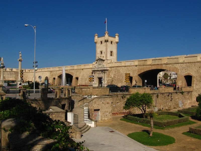
- Fortress of Candelaria The Baluarte de la Candelaria (fortress or stronghold of Candlemas) is a military fortification. Taking advantage of a natural elevation of land, it was constructed in 1672 at the initiative of the governor, Diego Caballero de Illescas. Protected by a seaward-facing wall that had previously served as a seawall, Candelaria's cannons were in a position to command the channels approaching the port of Cádiz. In more recent times, the edifice has served as a headquarters for the corps of military engineers and as the home to the army's homing pigeons, birds used to carry written messages over hostile terrain. Thoroughly renovated, it is now used as a cultural venue. There has been some discussion of using it to house a maritime museum, but, at present, it is designated for use as a permanent exposition space.
- The Casa del Almirante is a palatial house, adjacent to the Plaza San Martín in the Barrio del Pópulo, which was constructed in 1690 with the proceeds of the lucrative trade with the Americas. It was built by the family of the admiral of the Spanish treasure fleet, the so-called Fleet of the Indies, Don Diego de Barrios. The exterior is sheathed in exquisite red and white Genoan marble, prepared in the workshops of Andreoli, and mounted by the master, García Narváez. The colonnaded portico, the grand staircase under the cupola, and the hall on the main floor are architectural features of great nobility and beauty. The shield of the Barrios family appears on the second-floor balcony.
- The Roman theatre was discovered in 1980, in the El Pópulo district, after a fire had destroyed some old warehouses, revealing a layer of construction that was judged to be the foundations of some medieval buildings; the foundations of these buildings had been built, in turn, upon much more ancient stones, hand-hewn limestone of a Roman character. Systematic excavations have revealed a largely intact Roman theatre. The theatre, constructed by order of Lucius Cornelius Balbus (minor) during the 1st century BC, is the second largest Roman theatre in the world, surpassed only by the theatre of Pompeii, south of Rome. Cicero, in his Epistulae ad Familiares ("Letters to his friends"), wrote of its use by Balbus for personal propaganda.


Cagliari is the capital of the island of Sardinia, a region of Italy. Cagliari's Sardinian name Casteddu literally means castle. It has about 156,000 inhabitants, or about 480,000 including the outlying townships. An ancient city with a long history, Cagliari has seen the rule of several civilizations. It was the capital of the Kingdom of Sardinia (which in the 1861 became the Kingdom of Italy) from 1324 to 1720 and from 1798 to 1815. Seat of the important University of Cagliari and the Primate Roman Catholic archdiocese of Sardinia, the city is an important regional cultural, educational, political and artistic centre, known for its diverse Art Nouveau architecture and several monuments. It is also Sardinia's economic and industrial hub, having one of the biggest ports in the Mediterranean sea.

Cagliari offers museums and monuments, architecture and archaeological wonders which the different cultures that passed through or occupied Cagliari throughout its history have left behind. The Phoenicians, Romans, Vandals and the people from Byzantine, Pisa, Genoa, Aragona, Catalan, Spain and Piedmont have all left their mark on this ancient city.
There are many different routes that a tourist can follow to discover Cagliari. The route chosen will depend on how much time the visitor has, on the type of transport the visitor uses but most of all on the visitor's personal interests and preferences. For a brief tour a walk along via Roma and a visit to Castello in the historic old town, while people who are interested in art, architecture and archaeology can linger at the various sites along the route and visit the National Picture Galleries.
If you walk around the old historical quarters of the city, preferably with a good guidebook, you can easily identify the traces of the civilizations and rulers who, throughout the centuries, held sway in Cagliari. In the museums and churches one can find fascinating evidence of these influences.
Numerous open air archaeological sites and unspoiled natural environments allow unusual routes, rich in charm and beauty, between art and nature.
If you walk around the old historical quarters of the city, preferably with a good guidebook, you can easily identify the traces of the civilizations and rulers who, throughout the centuries, held sway in Cagliari. In the museums and churches one can find fascinating evidence of these influences.
 |
| Poetto Beach |
The main beach of Cagliari is the Poetto. It stretches for about eight kilometers, from Sella del Diavolo (the Devil's Saddle) up to the coastline of Quartu Sant'Elena. Poetto is also the name of the district located on the western stretch of the strip between the beach and Saline di Molentargius (Molentargius's Salt Mine). Another smaller beach is that of Calamosca near the Sant'Elia district. Cagliari is close to other beautiful seaside locations, such as Maddalena Beach, Chia or Villasimius, still relatively unspoilt by tourism.
Besides a cultural life rich in theatre, opera, concerts and exhibitions, Cagliari offers a gastronomy which is rich in both sea food and meat dishes which is guaranteed to satisfy and delight even the most demanding palate. Visiting Cagliari means discovering a rich and varied style of cooking.
 |
| Bastione St Remy |
A Sardinian meal always begins with an appetizer: wild boar ham, sausage lamb or veal trotters, clams or mussels cooked alla marinara with white wine, garlic, and parsley,burrida (dogfish marinated in a walnut and garlic sauce), bottariga (salted, dried and pressed roe of tuna or mullet) served in paper thin slices with lemon and olive oil. The traditional Sardinian meats are spit-roasted suckling pig, baby lamb, and kid.
The more adventurous might want to try sa cordula, cleaned lamb intestines sauté ed with peas, or knotted into an intricate braid with variety meats and oven or spit roasted. Another specialty issanguinaccio, a pork-blood sausage sweetened with raisins and sugar, served boiled or roasted.
Cagliari’s Top 5:
- Cagliari Castle. The Castle District is the oldest of the four historic neighborhoods of the city of Cagliari. Located in position on a hill, about a hundred meters above sea level. The Pisans founded this neighborhood in the thirteenth century, fortified, and with walls, towers and bastions, and there established the headquarters of the civil, military and religious. From then until after World War II, the Castle has always hosted the the palaces of power and mansions, as the premises of the main institutions of the Kingdom of Sardinia. The medieval quarter of Castello is the symbol and heart of the city of Cagliari, with its mighty walls that still surround much of the perimeter of the Castle, the imposing tower of Pisa and San Pancrazio dell'Elefante, the Bastion of Saint Remy and Porta dei Leoni, the Cathedral of Santa Maria, the narrow alleys and ancient buildings, such as the Royal Palace or Viceregio, the museum of the Citadel of Museums, antique shops and artisans.
- The Cathedral of Cagliari. The church was built in the 13th century in Pisane-Romanesque style, obtaining the cathedral status in 1258. In the 17th and 18th centuries it was renovated along Baroque lines. In the 1930s it finally received the current façade, in a Neo-Romanesque style, inspired to the Cathedral of Pisa.
The church was built by the Pisans in their stronghold overlooking the city, Castel di Castro. It had a square plan, with a nave and two aisles, the latter having cross vaults, while the nave had a wooden ceiling. In 1258, after the Pisans had destroyed the capital of the Giudicato of Cagliari, Santa Igia, and of its cathedral, it became the seat of the diocese of Cagliari. In the 14th century the transept was built, by which the cathedral obtained a Latin cross plan, and the two side entrances. The façade also obtained a Gothic mullioned window and the bell tower was also modified. From the same period is the first chapel, in Italian Gothic style, in the transept's left arm. The right transept was completed after the conquest of Cagliari by the Aragonese, and two further chapels were built. The old façade was demolished in the early 20th century, and replaced by a Neo-Romanesque one, along the same lines of the original design, during the 1930s. - The Basilica of San Saturnino is a Palaeo-Christian church, mentioned for the first time in the early 6th century. This church had been likely erected near the burial place of St. Saturninus of Cagliari, who, according to the Passio sancti Saturni (a medieval document telling the saint's story), had been martyred in 304. In 1089 the giudice of Cagliari, Constantine II of Cagliari, donated the complex, including also a monastery, was given by to the Benedictines of the Abbey of St. Victor of Marseille. In the occasion the church was restored in Provençal-Romanesque style. The renewed basilica was consecrated in 1119. In the following centuries the complex decayed. In 1614 the area was excavated in search of the relics of Cagliari's early martyrs, later brought in the city's Cathedral. In 1669 some material from San Saturnino were re-used for the Baroque renovation of the latter church. In 1714 the church was re-dedicated to Sts. Cosmas and Damian. In 1943 the church was damaged by Allied bombings. After World War II it was restored. In 1978-1996 the church remained closed for restorations. It was reconsecrated in 2004.
- Bastione St. Remy. The Bastion, which is adorned with palms, holm-oak, Aleppo pine and two different kinds of Washingtonia, was built on the oldest bulwarks of Zecca and Sperone. Its facade is made of granite and yellow and white marble. The terrace Umberto I and the Covered Walk (Passeggiata Coperta) were built in the early 1900s They were designed by the architect Giuseppe Costa. From the vantage point of Bastion of S: Remy the historical areas of Marina and Villanova, much of the new town, the plain of Campidano, the mirror surface of the pond of Molentargius and the mountains of Serpeddì and Sette Fratelli can be seen. The Covered Walk way is nowadays used as it was in the past for exhibitions and performances.
- The Roman Amphitheatre - Built in the second century, is the most important archaeological remnant of Roman Cagliari, and the most significant monument in existence in Sardinia. L 'amphitheater, located at the foot of a hill , was partially excavated from the rock and partly built using limestone blocks extracted from quarries nearby. The whole monument was covered with fine materials, as shown in the large amount of thin plates of marble found in the excavations. The amphitheatre, which could hold up to 10,000 spectators, can still be seen to this day in its elliptical steps, the cavea, fences and underground. The shows held there were many including gladiatorial games, pantomimes and executions. Even today, the amphitheater, partly covered by a wooden structure, is home to concerts and shows during the summer season.

The Basilica of San Saturnino


Canterbury

Canterbury is a historic English cathedral city, which lies at the heart of the City of Canterbury, a district of Kent in South East England. It lies on the River Stour.
Originally a Brythonic settlement, it was renamed Durovernum Cantiacorum by the Roman conquerors in the 1st century AD. After it became the chief Jutish settlement, it gained its English name Canterbury, itself derived from the Old English Cantwareburh ("Kent people's stronghold"). After the Kingdom of Kent's conversion to Christianity in 597, St Augustine founded an episcopal see in the city and became the first Archbishop of Canterbury, a position that now heads the Church of England and the worldwide Anglican Communion (though the modern-day Province of Canterbury covers the entire south of England).
 |
| St Augustines Abbey |
Thomas Becket's murder at Canterbury Cathedral in 1170 led to the cathedral becoming a place of pilgrimage for Christians worldwide. This pilgrimage provided the theme for Geoffery Chaucer's 14th-century literary classic The Canterbury Tales. The literary heritage continued with the birth of the playwright Christopher Marlowe in the city in the 16th century.
Many historical structures remain in the city, including a city wall founded in Roman times and rebuilt in the 14th century, the ruins of St Augustine's Abbey and a Norman castle, and perhaps the oldest school in England, The King's School.
 Canterbury's array of shop windows beckon with a kaleidoscope of colours, inviting you to sample what's on offer. Many of the high street names are here as well as a delightful range of independent retailers. The King's Mile has an atmosphere all of its own while the city's St Dunstan's, West Gate Towers and Northgate areas have a range of specialist and individual outlets. There are a number of markets that take place throughout the Canterbury district from weekly general markets to farmers' markets.
Canterbury offers a vast range of fantastic eateries. There is something to satisfy all taste buds; whether you want a Michelin star gourmet meal, a romantic meal for two or a meal with a party atmosphere, there is a venue to suit all desires. Or maybe you just want to sit down, relax and watch the world go by in one of our numerous cafés or tea shops serving home baked food and a cup of English tea.
 There are two excellent seaside towns in the Canterbury district. Those in search of traditional seaside magic will find it in Herne Bay. Beautiful beaches and stunning Victorian architecture combine to form the perfect backdrop to create stunning holiday memories. Brightly coloured beach huts reflect the great character of this seaside town. Sporting enthusiasts including rowers, yachtsmen and jet ski riders pursue their passion in Herne Bay's waters, adding a thrilling dimension to natural marine qualities.
Whitstable's traditional charms, strong arts culture and rich maritime history sit easily with its renaissance. Along the coast at Tankerton, grassy slopes dip to meet the sea. Many roads in Whitstable will lead you to the sea. Whether you take the main route through the town or enjoy haphazard progress through quiet lanes and alleyways with eccentric names such as Squeeze Gut Alley, you'll end up at the harbour.
Many historical structures remain in the city, including a city wall founded in Roman times and rebuilt in the 14th century, the ruins of St Augustine's Abbey and a Norman castle, and perhaps the oldest school in England, The King's School.

Canterbury offers a vast range of fantastic eateries. There is something to satisfy all taste buds; whether you want a Michelin star gourmet meal, a romantic meal for two or a meal with a party atmosphere, there is a venue to suit all desires. Or maybe you just want to sit down, relax and watch the world go by in one of our numerous cafés or tea shops serving home baked food and a cup of English tea.
 There are two excellent seaside towns in the Canterbury district. Those in search of traditional seaside magic will find it in Herne Bay. Beautiful beaches and stunning Victorian architecture combine to form the perfect backdrop to create stunning holiday memories. Brightly coloured beach huts reflect the great character of this seaside town. Sporting enthusiasts including rowers, yachtsmen and jet ski riders pursue their passion in Herne Bay's waters, adding a thrilling dimension to natural marine qualities.
Whitstable's traditional charms, strong arts culture and rich maritime history sit easily with its renaissance. Along the coast at Tankerton, grassy slopes dip to meet the sea. Many roads in Whitstable will lead you to the sea. Whether you take the main route through the town or enjoy haphazard progress through quiet lanes and alleyways with eccentric names such as Squeeze Gut Alley, you'll end up at the harbour.
One of the district's major natural assets is the 14.5 miles of coastline stretching from Seasalter to Reculver and attracts a large number of visitors and water sports enthusiasts.
Canterbury’s Top 5:
- Canterbury Cathedral. St Augustine, sent by Pope Gregory the Great, arrived in 597AD as a missionary and became the first Archbishop, establishing his seat (or 'Cathedra') in Canterbury. In 1170 Archbishop Thomas Becket was murdered in the Cathedral and ever since, the Cathedral has attracted thousands of pilgrims, as told most famously in Geoffrey Chaucer's Canterbury Tales. The Cathedral houses a Romanesque Crypt, dating back to the 11th century, a 12th century early Gothic Quire and a 14th Century Perpendicular Nave. Beautiful medieval stained glass windows illustrate miracles and stories associated with St Thomas. Visitor facilities range from guided tours and audio tours to private evening tours and 'behind the scenes' tours to the Stained Glass Studio, Archives and/or Library.
- Canterbury Castle was one of the three original Royal castles of Kent (the other two being Rochester Castle and Dover Castle). They were all built soon after the Battle of Hastings, on the main Roman road from Dover to London. This was the route taken by William the Conqueror in October 1066, and they were built originally as motte-and-bailey castles to guard this important route. A wooden motte and bailey castle was erected in 1066 - its motte may be the mound which is still visible in the Dane John gardens near the stone castle (which may in turn be a Roman burial mound), with Dane John deriving from donjon. The great stone keep was largely constructed in the reign of Henry I. This massive structure, which has dimensions of about 98 by 85 feet externally at the base, was originally probably at least 80 feet high. It is mainly made of flint and sandstone rubble. By the 13th century the castle had become the county gaol. It was given up to the invading French in the First Barons' War. In 1380 a new gate was built. By 1770, the castle had fallen into disrepair, and many parts of it were demolished during the late 18th century and early 19th century. In 1787 all the gates in the city wall, except for Westgate– the city jail – were demolished as a result of a commission that found them impeding to new coach travel.
- The Roman Museum. Houses a Roman pavement which is a scheduled monument, in the remains of a Roman courtyard house which itself is a grade I listed building. The pavement was discovered after World War II bombing, and has been open to the public since 1946. It houses many excavated artifacts from Roman Canterbury together with reconstructions of the Roman town. The museum aims to show what the Roman city was like, and to reveal the secret city beneath the feet of the visitor, thereby educating the public to appreciate local history. Each step by which one descends to the Roman pavement represents 100 years-worth of archaeological layers down to the 300 AD layer of the pavement.
- St Augustine's Abbey. In 597 Saint Augustine arrived in England, having been sent by Pope Gregory I, on what might nowadays be called a revival mission. The King of Kent at this time was Æthelberht, who happened to be married to a Christian, Bertha. Whether or not his spouse influenced him, he allowed Augustine to found a monastery just outside the walls of Canterbury to the east of the city. King Æthelberht ordered the church to be erected of "becoming splendour, dedicated to the blessed apostles Peter and Paul, and endowed it with a variety of gifts" William Thorne, the late fourteenth-century chronicler of the Abbey, records 598 as the year of the foundation. One of the main purposes of the abbey right from the outset was as a burial place for the Kings of Kent and the Archbishops of Canterbury. In 978 a new larger building was dedicated by Archbishop Dunstan, to the Saints Peter, Paul, and Augustine. Now a World Heritage Site, the ruins of this important monastic foundation built by Saint Augustine are in the care of English Heritage. Today the ruin precincts cover a substantial area east of the cathedral, and in fact, in its heyday the abbey's church rivalled nearby Canterbury Cathedral in size.
The Canterbury Tales. Ever wondered what it would be like to step back in time and experience the sights, sounds and smells of a bygone era, at The Canterbury Tales you can do just that. Step into medieval Canterbury and accompany Geoffrey Chaucer's colourful characters on their magical pilgrimage from London to the shrine of St Thomas Becket in Canterbury Cathedral. Along the way, their stories of love, romance, jealousy and trickery are vividly re-created with all the fun and excitement of Chaucer's famous tales. Steeped in the rich history of this medieval city, at The Canterbury Tales you really can visit another world. The Canterbury Tales is a stunningly accurate recreation of medieval life. With new audio guides in 6 languages, it provides an excellent introduction to the City and its famous literary connection.
The Canterbury Tales Exhibition Centre

References: http://www.canterbury.co.uk
Carcassonne

Throughout the centuries the historic site of Carcassonne has played a decisive role in the history of Languedoc. although both the Romans and the Visigoths ruled over Carcassonne, the city-state flourished in the possession of the powerful Viscount Trencavel who ruled over Bas-Languedoc. At the end of the crusade against the Albigensians the city, with its improved fortifications, became one of the strongholds symbolising royal power on the frontier between France and Aragon. However, after the Treaty of the Pyrenees made the Roussillon a French possession, the city lost its strategic role and its defence works were neglected. In the 19th Century, the residents of Carcassonne and the Historic Monuments Department (Service des Monuments historiques), commissioned Eugène Viollet-le-Duc to restore the ancient fortress to its original appearance. It was this project which helped save Carcassonne and ensure that the city of today is so outstandingly beautiful.
 Our visit to Carcassonne was in late September, the perfect time of year for a stress-free short break, in the summer months the city can be over populated and cramped. After a short, 10 Euro taxi ride from the airport to the13th century Porte Narbonnaise to the east of the walls, if , as we were, you are booked into one of the two hotels inside the cite, a smart car appears from nowhere to take you into the city itself. Manoeuvring through some of the tightest gates and round the sharpest corners, this (free) journey itself brings a huge smile to your face before your adventure has even began.
The cite is truly captured in time, tiny, winding cobbled streets opening out into glorious squares lined with cafes and restaurants make you almost feel like you are on a film set (in fact parts of the city have been used as a backdrop for many Hollywood blockbusters, most notably Robin Hood, Prince of thieves with Kevin Costner).
 We decided to use our first day to discover the new town or low town (Ville Basse). The Ville Basse is located on the left bank. It contains most of Carcassonne’s business activity, and two 13th century churches: The Cathedral of Saint Michael and the Church of Saint Vincent.
Whilst the medieval Cité is Carcassonne’s main attraction, there is plenty to do in the Ville Basse, the modern town. In 1260 the Bastide Saint-Louis was created to house the population whose villages flanking the Cité had been destroyed. This new town now lies at the centre of the Ville Basse, and the main Tourism Office runs guided tours of its main attractions. One of these is the Musée des Beaux-Arts, which houses a collection of paintings from the 17th to the 20th century. Within the Bastide, at the Place Carnot, there is a lively food market on Tuesdays, Thursdays and Saturdays. The Ville Basse also offers a wide selection of restaurants, some specialising in local produce, and cuisine such as the famous cassoulet stew.
 The Cité is a very popular tourist attraction. Within the ramparts, the Cité still houses a resident population of about 120 people, and alongside the many bistros and gift shops, there are also all the usual facilities that you would expect for a small town - a post office, a school, a hotel, etc. The Cité includes the Basilique Saint-Nazaire, an open air theatre and the fortified Chateau Comtal within its double ramparts. The walls consist of a vast circle of double battlements, enclosing medieval streets, containing many boutiques, souvenir shops, and restaurants. It relies heavily on tourism. The outer ramparts connect 14 towers, and are separated by the outer bailey and inner ramparts, which has 24 towers. On the 14th July there is a massive firework display to celebrate Bastille Day, in which the whole of the Cite appears to go up in flames.
The Tourist Information Centre houses a scale model of the Cité - a very useful way to view the immense size, and complexity of the fortified town, and to get your bearings.
Carcassonne’s Top 5:
- The walls of the Cité. The upper town is surrounded by a double wall – the area in-between is known as the lices or “lists” where medieval knights once did their thing. Whilst the outer wall is the work of Louis IX, parts of the inner wall date back to Roman times.
- Château Comtal. The citadel of the upper town dating from the twelfth century with an amazing 31 towers. There are mandatory guided tours of the château which also take in sections of the walls and the amphitheatre.
- St-Nazaire basilica. Pope Urban V (born near Mende in the north of Languedoc) visited here in 1096 and ordered the construction of the basilica. However, the original Romanesque style is now predominantly Gothic after alterations over the years – the best features are its enormous rose windows and the weird gargoyles.
- Pont Vieux and the banks of the Aude. A wonderful place for a picnic once you’ve done the upper town. The bridge dates from the fourteenth century and boasts a Gothic chapel at its western end dating from 1538.
- Local delicacies - Place du Château. This gloriously old-fashioned store is stuffed full of regional specialties such as cassoulet and olives aux herbes. If you’re craving cakes and pastry, it’s also the place to stock up on grés de la cité, a Carcassonne favourite that features a heavenly mix of almonds and vanilla wrapped in puff pastry.


References: http://www.languedoc-roussillon.eu.com/carcassonne.htm
All photographs by Tony & Michelle Bonson 2010
Cardiff

Cardiff is the capital and largest city in Wales and the 10th largest city in the United Kingdom. The city is Wales' chief commercial centre, the base for most national cultural and sporting institutions, the Welsh national media, and the seat of the National Assembly for Wales. Cardiff is a significant tourism centre and the most popular visitor destination in Wales with 18.3 million visitors in 2010. In 2011, Cardiff was ranked 6th in the world in National Geographic's alternative tourist destinations.
The city of Cardiff is the county town of the historic county of Glamorgan (and later South Glamorgan). Cardiff is part of the Eurocities network of the largest European cities. The Cardiff Urban Area covers a slightly larger area outside of the county boundary, and includes the towns of Dinas Powys and Penarth. A small town until the early 19th century, its prominence as a major port for the transport of coal following the arrival of industry in the region contributed to its rise as a major city.

Situated on the narrowest part of the south Wales coastal plain, Cardiff had a crucial strategic importance in the wars between the Normans (who had occupied lowland Wales) and the Welsh who maintained their hold on the uplands. As a result Cardiff claims to have the largest concentration of castles of any city in the world. In addition to Cardiff Castle, Castell Coch (Red Castle) is located in Tongwynlais, in the north of the city. The current castle is an elaborately decorated Victorian folly designed by William Burges for the Marquess and built in the 1870s, as an occasional retreat. However, the Victorian castle stands on the footings of a much older medieval castle possibly built by Ifor Bach, a regional baron with links to Cardiff Castle also. The exterior has become a popular location for film and television productions. It rarely fulfilled its intended role as a retreat for the Butes, who seldom stayed there. For the Marquess, the pleasure had been in its creation, a pleasure lost following Burges's death in 1881. The remains of Twmpath Castle, the Llandaff Bishop's Palace and Saint Fagans Castle are still in existence, whilst the site of Treoda (or Whitchurch Castle) has now been built over.

Other major tourist attractions are the Cardiff Bay regeneration sites which include the recently opened Wales Millennium Centre and the Senedd, and many other cultural and sites of interest including the Cardiff Bay Barrage and the famous Coal Exchange. The New Theatre was founded in 1906 and completely refurbished in the 1980s. Until the opening of the Wales Millennium Centre in 2004, it was the premier venue in Wales for touring theatre and dance companies. Other venues which are popular for concerts and sporting events include Motorpoint Arena, St David's Hall and the Millennium Stadium. Cardiff Story, a museum documenting the city's history, is to open in Spring 2011.
Cardiff is a capital for shopping, and with a combination of designer brands, high street names as well as more individual and independent shops, there's something for everyone.
Recently named the 6th best shopping destination in the UK, Cardiff has the whole spectrum of shopping, with charming Edwardian and Victorian arcades and ultra-modern shopping centres. And when you've had your fill of retail therapy, there are plenty of cafés, restaurants and bars to stop and relax in.
 |
| Llandaff Cathedral Green |
Cardiff has over 1,000 listed buildings, ranging from the more prominent buildings such as the castles, to smaller buildings, houses and structures. Cardiff has walks of special interest for tourists and ramblers alike, such as the Centenary Walk, which runs for 2.3 miles (3.7 km) within Cardiff city centre. This route passes through many of Cardiff's landmarks and historic buildings.
Cardiff’s Top 5:
- Cardiff Castle. is a medieval castle and Victorian architecture Gothic revival mansion, transformed from a Norman keep erected over a Roman fort in the Castle Quarter of Cardiff. The Castle is a Grade I Listed Building. There may have been at least two previous Roman forts on the site. The first was probably built about AD 55 during the conquest of the Silures tribe. From the late 2nd to the mid-3rd century, civilian buildings associated with iron working occupied the site. In the 18th century the castle became the property of John Stuart, 3rd Earl of Bute, In the early 19th century the original Norman Castle had been enlarged and refashioned in an early Gothic Revival style . Bute despised the result and his interest in medieval Gothic Revivalism, combined with his almost limitless financial resources, led to Burges re-building on the grandest scale. Almost the entire of Burges's usual team were involved, including Chapple, Frame and Lonsdale. But it was Burges's imagination, his scholarship, his architectural and decorative talents, his inventiveness and his sheer high spirits that combined to make Cardiff Castle the "most successful of all the fantasy castles of the nineteenth century.
- St Fagans National History Museum. commonly referred to as St Fagans after the village where it is located, is an open-air museum chronicling the historical lifestyle, culture and architecture of the Welsh people. The museum is part of Amgueddfa Cymru - National Museum of Wales. It comprises over thirty re-erected buildings from various locations in Wales, and is set in the grounds of St Fagans Castle, an Elizabethan manor house. In 2011 Which? magazine named the museum the United Kingdom's favourite visitor attraction
- Llandaff Cathedral. The Cathedral Church of SS Peter & Paul, Dyfrig, Teilo and Euddogwy is the mother church of the Diocese of Llandaff and stands on one of the oldest Christian sites in Britain. The Cathedral lies in the ancient "City of Llandaff" much of which is now a conservation area. Despite being surrounded on all sides by the bustling modern city of Cardiff, the Llandaff conservation area remains comparatively unspoilt and surprisingly tranquil. The present cathedral dates from 1107 when Bishop Urban, the first Bishop appointed by the Normans, instigated the building of a much larger church. The arch behind the High Altar was built at that time. The Cathedral was extended and widened and a new West front built about 1220. This West front is judged by many to be one of the two or three most notable mediaeval works of art in Wales.
- Norwegian Church Arts Centre. Formerly a Church for Norwegian Sailors, where children's author Roald Dahl was christened, this is a landmark building on the Cardiff Bay waterfront and a renowned cultural venue. The unique venue hosts a variety of events, from live music to workshops, functions and classes. The Dahl Gallery also displays a range of art and photography exhibitions. The stylish café bar offers food all day, with the outside terrace overlooking the tranquil waters of the Bay.
- The Welsh National War Memorial is situated in Alexandra Gardens, Cathays Park. The memorial was designed by Sir Ninian Comper and unveiled in June 1928 by the Prince of Wales. The memorial commemorates the servicemen who died during the First World War and has a plaque for those who died during the Second World War, added in 1949. The memorial takes the form of a circular colonnade surrounding a sunken court. On the frieze above the columns are inscriptions in Welsh, on the outer side, and in English, on the inner side (see inset). The English inscription was composed by Comper himself. At the centre of the court is a group of bronze sculptures by Alfred Bertram Pegram, arranged around a stone pylon. Around the base stand three figures, a soldier, sailor and airman, holding wreaths aloft. There are appropriate inscriptions above the figures e.g. 'Over the sea he went to die', above the sailor. Above them, crowning the structure, is a winged male nude representing Victory.


Catania

Catania is an Italian city on the east coast of Sicily facing the Ionian Sea, between Messina and Syracuse. It is the capital of the homonymous province, and is the second-largest city in Sicily and the tenth in Italy.
Catania is known for its seismic history, having been destroyed by a catastrophic earthquake in 1169, another in 1693, and several volcanic eruptions from the neighboring Mount Etna volcano, the most violent of which was in 1669.
 All ancient authors agree in representing Catania as a Greek colony named Κατάνη of Chalcidic origin, but founded immediately from the neighboring city of Naxos, under the guidance of a leader named Euarchos (Euarchus).
The exact date of its foundation is not recorded, but it appears from Thucydides to have followed shortly after that of Leontini (modern Lentini), which he places in the fifth year after Syracuse, or 730 BC.
It appears to have continued afterwards steadily to maintain its friendly relations with Rome, and though it did not enjoy the advantages of a confederate city (foederata civitas), like its neighbors Tauromenium (modern Taormina) and Messana (modern Messina), it rose to a position of great prosperity under the Roman rule.
Cicero repeatedly mentions it as, in his time, a wealthy and flourishing city; it retained its ancient municipal institutions, its chief magistrate bearing the title of Proagorus; and appears to have been one of the principal ports of Sicily for the export of corn.
.jpg)
It subsequently suffered severely from the ravages of Sextus Pompeius, and was in consequence one of the cities to which a colony was sent by Augustus; a measure that appears to have in a great degree restored its prosperity, so that in Strabo's time it was one of the few cities in the island that was in a flourishing condition.
One of the most serious eruptions of Mount Etna happened in 121 BC, when great part of Catania was overwhelmed by streams of lava, and the hot ashes fell in such quantities in the city itself, as to break in the roofs of the houses.The port of Catania also, which was in great part filled up by the eruption of 1669 AD, appears to have been in ancient times much frequented, and was the chief place of export for the corn of the rich neighboring plains. The little river Amenanus, or Amenas, which flowed through the city, was a very small stream, and could never have been navigable.
In 1860 Giuseppe Garibaldi's expedition of the Thousand conquered Sicily for Piedmont from the Kingdom of the Two Sicilies. Since the following year Catania was part of the newly unified Italy, whose history it shares since then.
During World War II Catania was repeatedly bombed by the Allies, starting from 5 June 1940, and some 100,000 of its inhabitants were moved to the neighboring villages. It was evacuated by the Germans on 5 August 1943. After the conflict, and the constitution of Italian Republic (1946), the history of Catania was, like the history of other cities of southern Italy, an attempt to catch up with the economic and social development of the richer northern regions in the country and to solve the problems that for historic reasons plague the Mezzogiorno, namely a heavy gap in industrial development and infrastructures, and the threat of the mafia.
This notwithstanding, during the 1960s (and partly during the 1990s) Catania enjoyed a development and an economic, social and cultural effervescence. In the first decade of the 21st century, Catania economic and social development somewhat faltered and the city is again facing economic and social stagnation. This was aggravated by the economical crisis left by the Forza Italia administration of mayor Scapagnini in 2008.

The food and fish markets just below the Piazza del Duomo are a lively and colourful place to visit. This fish market is the busiest and most exotic of all over Sicily and has been described by the British TV chef Rick Stein as the best fish market in the world. Monday to Saturday morning only.
One of the most serious eruptions of Mount Etna happened in 121 BC, when great part of Catania was overwhelmed by streams of lava, and the hot ashes fell in such quantities in the city itself, as to break in the roofs of the houses.The port of Catania also, which was in great part filled up by the eruption of 1669 AD, appears to have been in ancient times much frequented, and was the chief place of export for the corn of the rich neighboring plains. The little river Amenanus, or Amenas, which flowed through the city, was a very small stream, and could never have been navigable.
Catania was sacked by the Vandals of Gaiseric in 440–441. After a period under the Ostrogoths, it was reconquered in 535 by the Eastern Roman Empire, under which (aside from a short period in 550–555) it remained until the 9th century. It was the seat of the Byzantine governor of the island.
 |
| Santa Maria dell'Elemosina |
Catania was under the Islamic emirate of Sicily until 1072, when it fell to the Normans of Roger I of Sicily. Subsequently the city was ruled a bishop-count. In 1194–1197 the city was sacked by German soldiers during after the conquest of the island by emperor Henry VI. In 1232 it rebelled to the former's son, Frederick II, who later built a massive castle, Castello Ursino and also made Catania a royal city, ending the dominance of the bishops. Catania was one of the main centers of the Sicilian Vespers revolt (1282) against the House of Anjou, and was the seat of the incoronation of the new Aragonese king of Sicily, Peter I. In the 14th century it gained importance as it was chosen by the Aragonese as a Parliament and Royal seat. Here, in 1347, it was signed the treaty of peace that ended the long War of the Vesper between Aragonese and Angevines. Catania lost its capital role when, in the early 15th century, Sicily was turned into a province of the larger Kingdom of Aragon, but kept some of its autonomy and privileges.
In 1434 King Alfonso V founded here the Siciliae Studium Generale, the oldest university in the island.
In 1434 King Alfonso V founded here the Siciliae Studium Generale, the oldest university in the island.
With the unification of Castile and Aragon (early 16th century), Sicily became part of the Spanish Empire. It rebelled against the foreign government in 1516 and 1647.
In 1669 the city's surroundings suffered great material damage from an eruption of Mount Etna. The city itself was largely saved by its walls that diverted most of the lava into the port. Afterwards in 1693 the city was then completely destroyed by a heavy earthquake and its aftershocks. The city was then rebuilt in the Baroque architecture that nowadays characterizes it.
In 1669 the city's surroundings suffered great material damage from an eruption of Mount Etna. The city itself was largely saved by its walls that diverted most of the lava into the port. Afterwards in 1693 the city was then completely destroyed by a heavy earthquake and its aftershocks. The city was then rebuilt in the Baroque architecture that nowadays characterizes it.
 |
| Castello Ursino |
Catania was one of the vanguards of the movement for the Sicilian autonomy in the early 19th century.
In 1860 Giuseppe Garibaldi's expedition of the Thousand conquered Sicily for Piedmont from the Kingdom of the Two Sicilies. Since the following year Catania was part of the newly unified Italy, whose history it shares since then.
During World War II Catania was repeatedly bombed by the Allies, starting from 5 June 1940, and some 100,000 of its inhabitants were moved to the neighboring villages. It was evacuated by the Germans on 5 August 1943. After the conflict, and the constitution of Italian Republic (1946), the history of Catania was, like the history of other cities of southern Italy, an attempt to catch up with the economic and social development of the richer northern regions in the country and to solve the problems that for historic reasons plague the Mezzogiorno, namely a heavy gap in industrial development and infrastructures, and the threat of the mafia.
This notwithstanding, during the 1960s (and partly during the 1990s) Catania enjoyed a development and an economic, social and cultural effervescence. In the first decade of the 21st century, Catania economic and social development somewhat faltered and the city is again facing economic and social stagnation. This was aggravated by the economical crisis left by the Forza Italia administration of mayor Scapagnini in 2008.
Catania has a unique cuisine, with strong Sicilian traits. Dishes such as Pasta alla Norma are from the city. Pasta alla Norma is a pasta dish made out of macaroni-like penne, tomato sauce, largely sliced aubergines, and often topped with salty ricotta, or ricotta salata in Italian. Granita, a popular flavoured sherbet, is believed to hail from the city too. Blood oranges, such as the famous tarocco, are common to the city and others. Another famous plate is horse's meat, usually cooked on coals and sold on the streets.

Throughout Sicily, you can get a freshly made cold panini in a “salumeria”, where you choose whatever you want to put in (prosciutto cotto/crudo and cheese is probably the most popular). Don’t forget that most of them are closed between 1-4PM and on Sunday afternoon. You can also have a tavola calda which mean “hot bite”, most of them made with cheese and meat, fried or baked. There is also the Sicilian speciality of arancino, which are deep fried rice balls with various fillings, meat or eggplant or spinach, that sell for €1,50 at most places. They make a good lunch snack. Finally, you will find, especially during the evening, big kiosks that sell hot, tasty and fat panini. Most people add fries into the sandwich. Usually, it’s about €2,50-3,00 and they are very popular among teenagers. Because its quite cheap, there is normally confusion at these kiosks.
The food and fish markets just below the Piazza del Duomo are a lively and colourful place to visit. This fish market is the busiest and most exotic of all over Sicily and has been described by the British TV chef Rick Stein as the best fish market in the world. Monday to Saturday morning only.

Catania’s Top 5:
- The Cathedral of Catania, entitled to St. Agatha, has been destroyed and rebuilt several times due earthquakes and eruptions of the nearby volcano Etna. It was originally constructed in 1078-1093, on the ruins of the ancient Roman Achillean Baths, by order of Roger I of Sicily, who had conquered the city from the Islamic emirate of Sicily. At the time it had the appearance of a fortified church (ecclesia munita). In 1169 it was nearly entirely destroyed by an earthquake, leaving only the apse area intact. Further damage was introduced by a fire in 1169, but the most catastrophic event was the 1693 earthquake, which again left it mostly in ruins. It was subsequently rebuilt in Baroque style. Today, traces of the original Norman edifice include part of the transept, the two towers and the three semicircular apses, composed of large lava stones, most of them recovered from imperial Roman buildings.
- Castello Ursino was built, circa from 1239 to 1250, as one of the royal castles of Emperor Frederick II, King of Sicily, closing a chapter on the turbulent time in Sicily that followed the death of his predecessor, William II. Local lords had attempted to assert independence, and in 1220 Frederick II had ordered the destruction of all non-royal castles in Sicily Castle Ursino was built to stress royal power as well as for the defence of the capital, and was considered impregnable at the time. In 1295, during the Sicilian Vespers, the Parliament which declared deposed James II of Aragon as King of Sicily, replacing him with Frederick III, was held here. The following year it was captured by Robert of Anjou but was later again in Aragonese hands. King Frederick III resided in the castle, as well as his successors Peter II, Louis, Frederick IV and Maria. Here the latter was kidnapped by Guglielmo Raimondo III Moncada to avoid her marriage with Gian Galeazzo Visconti (1392). King Martin I held also his court in the castle.
- The Basilica della Collegiata (also known as Santa Maria dell'Elemosina) is a church in Catania. Finished in 1768, it is an example of Sicilian Baroque. The church was built in the early 18th century, after the earthquake of 1693 that had destroyed most of the city. The design of the church is attributed to Angelo Italia, who changed the orientation of the previous edifice destroyed by the earthquake, in order to have it facing the new via Uzeda (current Etnea Street) according to the rebuilding plan of the city. The façade, designed by Stefano Ittar, is one of the most notable examples of Sicilian Baroque in Catania.
- Palazzo degli Elefanti is a historical building which currently houses the city's Town Hall. The palace, located on the northern side of the Cathedral square, was begun in 1696 after the devastating earthquake of 1693, its original designed having been commissioned to Giovan Battista Longobardo. The eastern, southern, and western façades were however designed at a later stage by Giovan Battista Vaccarini, while the northern one was by Carmelo Battaglia. The staircase opening to the inner court with four porticoes was added in the late 18th century by Stefano Ittar. On the second floor are paintings by the Sicilian artist Giuseppe Sciuti.
- u Liotru. The symbol of the city is u Liotru, or the Fontana dell'Elefante, assembled in 1736 by Giovanni Battista Vaccarini. It portrays an ancient lavic stone elephant and is topped by an Egyptian obelisk from Syene. Legend has it that Vaccarini's original elephant was neuter, which the men of Catania took as an insult to their virility. To appease them, Vaccarini appropriately appended elephantine testicles to the original statue. The Sicilian name u Liotru is a phonetic change of Heliodorus, a nobleman who, after trying without success to become bishop of the city, became a sorcerer and was therefore condemned to the stake. Legend has it that Heliodorus himself was the sculptor of the lava elephant and that he used to magically ride it in his fantastic travels from Catania to Constantinople. Another legend has it that Heliodorus was able to transform himself into an elephant.


Chester

Chester is a city in Cheshire, England. Lying on the River Dee, close to the border with Wales, it is the largest and most populous settlement of the wider unitary authority area of Cheshire West and Chester. Chester was granted city status in 1541.
The Romans founded Chester as Deva Victrix in the 70s AD in the land of the Celtic Cornovii, according to ancient cartographer Ptolemy, as a fortress during the Roman expansion northward. It was named Deva either after the goddess of the Dee, or directly from the British name for the river. The 'victrix' part of the name was taken from the title of the Legio XX Valeria Victrix which was based at Deva. A civilian settlement grew around the military base, probably originating from trade with the fortress. The fortress was 20% larger than other fortresses in Britannia built around the same time at York (Eboracum) and Caerleon (Isca Augusta); this has led to the suggestion that the fortress, rather than London (Londinium), was intended to become the capital of the Roman province of Britannia Superior.

The civilian amphitheatre, which was built in the 1st century, could seat between 8,000 and 10,000 people. It is the largest known military amphitheatre in Britain, and is also a Scheduled Monument. The Minerva Shrine in the Roman quarry is the only rock cut Roman shrine still in situ in Britain. The fortress was garrisoned by the legion until at least the late 4th century. Although the army had abandoned the fortress by 410 when the Romans retreated from Britannia, the Romano-British civilian settlement continued (probably with some Roman veterans staying behind with their wives and children) and its occupants probably continued to use the fortress and its defences as protection from raiders from the Irish Sea.
Chester was captured from the Britons by the Kingdom of Northumbria after the brutal and decisive Battle of Chester in the early 7th century. Deverdoeu was still one of two Welsh language names for Chester in the late 12th century; its other and more enduring Welsh name was Caerlleon, literally "the fortress-city of the legions", a name identical with that of the Roman fortress at the other end of the Welsh Marches at Caerleon in Monmouthshire, namely Isca Augusta. The modern Welsh name is the shortened form, Caer.

The early Old English speaking Anglo Saxon settlers used a name which had the same meaning, Legacæstir, which was current until the 11th century, when, in a further parallel with Welsh usage, the first element fell out of use and the simplex name Chester emerged. From the 14th century to the 18th century the city's prominent position in North West England meant that it was commonly also known as Westchester. This name was used by Celia Fiennes when she visited the city in 1698.
Chester played a significant part in the Industrial Revolution which began in the North West of England in the latter part of the 18th century. The city village of Newtown, located north east of the city and bounded by the Shropshire Union Canal was at the very heart of this industry. The large Chester Cattle Market and the two Chester railway stations, Chester General and Chester Northgate Station, meant that Newtown with its cattle market and canal, and Hoole with its railways were responsible for providing the vast majority of workers and in turn, the vast amount of Chester's wealth production throughout the Industrial Revolution.
A considerable amount of land in Chester is owned by the Duke of Westminster who owns an estate, Eaton Hall, near the village of Eccleston. He also has London properties in Mayfair.
Grosvenor is the Duke's family name, which explains such features in the City such as the Grosvenor Bridge, the Grosvenor Hotel, and Grosvenor Park. Much of Chester's architecture dates from the Victorian era, many of the buildings being modelled on the Jacobean half-timbered style and designed by John Douglas, who was employed by the Duke as his principal architect. He had a trademark of twisted chimney stacks, many of which can be seen on the buildings in the city centre.
Grosvenor is the Duke's family name, which explains such features in the City such as the Grosvenor Bridge, the Grosvenor Hotel, and Grosvenor Park. Much of Chester's architecture dates from the Victorian era, many of the buildings being modelled on the Jacobean half-timbered style and designed by John Douglas, who was employed by the Duke as his principal architect. He had a trademark of twisted chimney stacks, many of which can be seen on the buildings in the city centre.

Douglas designed amongst other buildings the Grosvenor Hotel and the City Baths. In 1911, Douglas' protégé and city architect James Strong designed the then active fire station on the west side of Northgate Street. Another feature of all buildings belonging to the estate of Westminster is the 'Grey Diamonds' – a weaving pattern of grey bricks in the red brickwork laid out in a diamond formation.
Towards the end of World War II, a lack of affordable housing meant many problems for Chester. Large areas of farmland on the outskirts of the city were developed as residential areas in the 1950s and early 1960s producing, for instance, the suburb of Blacon. In 1964, a bypass was built through and around the town centre to combat traffic congestion.
These new developments caused local concern as the physicality and therefore the feel of the city was being dramatically altered. In 1968, a report by Donald Insall in collaboration with authorities and government recommended that historic buildings be preserved in Chester. Consequently, the buildings were used in new and different ways instead of being flattened.
 In 1969 the City Conservation Area was designated. Over the next 20 years the emphasis was placed on saving historic buildings, such as The Falcon Inn, Dutch Houses and Kings Buildings.
On 13 January 2002, Chester was granted Fairtrade City status. This status was renewed by the Fairtrade Foundation on 20 August 2003.
Towards the end of World War II, a lack of affordable housing meant many problems for Chester. Large areas of farmland on the outskirts of the city were developed as residential areas in the 1950s and early 1960s producing, for instance, the suburb of Blacon. In 1964, a bypass was built through and around the town centre to combat traffic congestion.
These new developments caused local concern as the physicality and therefore the feel of the city was being dramatically altered. In 1968, a report by Donald Insall in collaboration with authorities and government recommended that historic buildings be preserved in Chester. Consequently, the buildings were used in new and different ways instead of being flattened.

On 13 January 2002, Chester was granted Fairtrade City status. This status was renewed by the Fairtrade Foundation on 20 August 2003.

Chester’s Top 5:
- Chester Cathedral is the mother church of the Church of England Diocese of Chester. The cathedral, formerly St Werburgh's abbey church of a Benedictine monastery, is dedicated to Christ and the Blessed Virgin Mary. Since 1541 it has been the seat of the Bishop of Chester and centre of worship, administration, ceremony and music for the city and diocese. The cathedral is a Grade I listed building, and part of a heritage site that also includes the former monastic buildings to the north, also listed Grade I. The cathedral, typical of English cathedrals in having been modified many times, dates from between 1093 and the early 16th century, although the site itself may have been used for Christian worship since Roman times. All the major styles of English medieval architecture, from Norman to Perpendicular, are represented in the present building.
- The Eastgate Clock stands on the site of the original entrance to the Roman fortress of Deva Victrix. It is a prominent landmark in the city of Chester and is said to be the most photographed clock in England after Big Ben. The original gate was guarded by a timber tower which was replaced by a stone tower in the 2nd century, and this in turn was replaced probably in the 14th century. The present gateway dates from 1768 and is a three-arched sandstone structure which carries the walkway forming part of Chester city walls. In 1899 a clock was added to the top of the gateway to celebrate the diamond jubilee of Queen Victoria two years earlier. It is carried on openwork iron pylons, has a clock face on all four sides, and a copper ogee cupola. The clock was designed by the Chester architect John Douglas. The whole structure, gateway and clock, was listed by English Heritage on 28 July 1955 as a Grade I listed building.
- Chester Rows consist of covered walkways at the first floor behind which are entrances to shops and other premises. At street level is another set of shops and other premises, many of which are entered by going down a few steps. The Rows, found in each of the four main streets of the city, are unique; nothing precisely similar exists anywhere else in the world. Dating from the medieval era, the Rows may have been built on top of rubble remaining from the ruins of Roman buildings, but their origin is still subject to speculation. In some places the continuity of the Rows has been blocked by enclosure or by new buildings, but in others modern buildings have retained the Rows in their designs. Undercrofts or "crypts" were constructed beneath the buildings in the Rows. The undercrofts were in stone while most of the buildings in the Rows were in timber.
- Chester Town Hall is in Northgate Street in the centre of the city. In 1698 an Exchange was built to accommodate the city's administrators. This building burnt down in 1862. A competition was held to build a new town hall and this was won by William Henry Lynn of Belfast. The building cost £40,000 (£2,850,000 as of 2012). It was officially opened on 15 October 1869 by the Prince of Wales (the future Edward VII) who was accompanied by W. E. Gladstone, the Prime Minister. On 27 March 1897 the council chamber on the second floor was gutted by fire. It was restored by T. M. Lockwood the following year. In 1979 a clock was installed in the tower with three faces; there is no face on the west side of the tower.
- Chester city walls consist of a defensive structure built to protect the city. Their construction was started by the Romans when they established the fortress of Deva Victrix between 70 and 80 AD. It originated with a rampart of earth and turf surmounted by a wooden palisade. From about 100 AD they were reconstructed using sandstone, but were not completed until over 100 years later. Following the Roman occupation nothing is known about the condition of the walls until Æthelflæd refounded Chester as a burgh in 907. The defences were improved, although the precise nature of the improvement is not known. After the Norman conquest, the walls were extended to the west and the south to form a complete circuit of the medieval city. The circuit was probably complete by the middle of the 12th century.


Cologne

Cologne (Köln) is Germany's fourth-largest city, and is the largest city both in the Germany Federal State of North Rhine-Westphalia and within the Rhine-Ruhr Metropolitan Area, one of the major European metropolitan areas with more than ten million inhabitants. Cologne is located on both sides of the Rhine River.
 |
| Heumarkt |
Cologne is a major cultural centre of the Rhineland and has a vibrant arts scene. Cologne is home to more than 30 museums and hundreds of galleries. Exhibitions range from local ancient Roman archeological sites to contemporary graphics and sculpture.
Cologne is one of the most popular cities in Europe for shopping. The most popular shopping streets are Schildergasse and Hohe Straße. Those who like trendy boutiques should make a detour to nearby Ehrenstraße. There's also a wealth of shopping opportunities in the arcades in the city centre and along the Ring. Here you can shop till you drop in an ultramodern atmosphere — and fortify yourself afterward with exquisite local delicacies in one of the many lively coffee bars. Less well-known, but therefore all the cosier, is a shopping tour through the high streets of the individual neighbourhoods.
 |
| Hohenzollern Bridge and Cathedral |
Cologne is one of the most popular cities in Europe for shopping. The most popular shopping streets are Schildergasse and Hohe Straße. Those who like trendy boutiques should make a detour to nearby Ehrenstraße. There's also a wealth of shopping opportunities in the arcades in the city centre and along the Ring. Here you can shop till you drop in an ultramodern atmosphere — and fortify yourself afterward with exquisite local delicacies in one of the many lively coffee bars. Less well-known, but therefore all the cosier, is a shopping tour through the high streets of the individual neighbourhoods.
Cologne is massively famous for Eau de Cologne, a perfume created by Italian expatriate Johann Maria Farina at the beginning of the 18th century. During the 18th century this perfume became increasingly popular, was exported all over Europe by the Farina family and Farina became a household name for Eau de Cologne. In 1803 Wilhelm Mülhens entered into a contract with an unrelated person from Italy named Carlo Francesco Farina who granted him the right to use his family name and Mühlens opened a small factory at Cologne's Glockengasse. In later years and after various court battles his grandson Ferdinand Mülhens had to abandon the nameFarina for the company and their product. He decided to use the house number given to the factory at Glockengasse during French occupation in the early 19th century: 4711. Today, original Eau de Cologne is still produced in Cologne by both the Farina family, currently in the eighth generation, and by Mäurer & Wirtz who bought the 4711 brand in 2006.
Cologne’s Top 5:
- Cologne Cathedral "Kölner Dom". The Kölner Dom is one of the architectural masterpieces of mankind, started in 1248, and completed in 1880. In 1996 it was declared a World Cultural Heritage Site as a perfect example of Gothic construction, the Cathedral is the symbol of the metropolis on the Rhine. And with about six million visitors a year, Germany's largest Cathedral is also the country's most popular architectural monument. Its size is emphasized by a gigantic pair of towers that dominated the city panorama since their completion in 1880. The cathedral houses the Shrine of the Three Kings that supposedly contains the relics of the Three Magi. Residents of Cologne sometimes refer to the cathedral as "the eternal construction site"
- The City Hall. is a historical building, located off Hohe Straße in the district of Innenstadt, set between the two squares of Rathausplatz and Alter Markt. It houses part of the city government, including the city council and offices of the Lord Mayor. It is Germany's oldest city hall with a documented history spanning some 900 years. The history of its council during the 11th century is a prominent example for self-gained municipal autonomy of Medieval cities. Today's building complex consists of several structures, added successively in varying architectural styles: they include the 14th century historic town hall, the 15th century Gothic style tower, the 16th century Renaissance style loggia and cloister (the Löwenhof), and the 20th century Modern Movement atrium (the Piazzetta).
- The Hohenzollern Bridge Originally, the bridge was both a railway and street bridge, however, after its destruction in 1945 and its subsequent reconstruction, it was only accessible to rail and pedestrian traffic. It is the most heavily used railway bridge in Germany, connecting the Köln Hauptbahnhof and Köln Messe/Deutz stations with each other. The bridge was constructed between 1907 and 1911 after the old bridge, the Cathedral Bridge (Dombrücke), was demolished. The Cathedral Bridge was unable to handle the increasing traffic in Cologne. It was named after the House of Hohenzollern.
The Hohenzollern Bridge was one of the most important bridges in Germany during World War II; even under consistent daily airstrikes the bridge was not badly damaged. On 6 March 1945, German military engineers blew up the bridge when Allied troops began their assault on Cologne. After the war, reconstruction was quickly organized; by 8 May 1948, the Hohenzollern Bridge was accessible by pedestrians again. Over the next eleven years the bridge was improved until by 1959 it was usable without any impairment. During the 1980s, the bridge was renovated with two new tracks. The Hohenzollern Bridge now regularly has over 1200 trains pass through daily. The bridge is regarded as an important part of Cologne as it connects Cologne's central station with major European cities on the other side of the Rhine. - The Heumarkt ("Hay Market") is one of the biggest squares in the center of Cologne and the place where everything happens. In the middle ages this was the place where hay for the horses and other commodities were traded. The buildings and roads surrounding and on the square have changed repeatedly to adapt to the changing requirements. A car park under the square was completed in 2001. The entrances are in two glass buildings on the edge of the square. The Heumarkt is a location for cultural festivities like open-air concerts, carnival events, wine festivals and christmas fairs.
Museum Ludwig. As well as holding one of the largest Picasso collections in Europe (over 900 pieces), the Museum Ludwig houses a huge collection of modern art. It includes works from PopArt, Abstract and Surrealism, It also features many works by Andy Warhol and Roy Lichtenstein. The museum emerged in 1976 as an independent institution from the Wallraf-Richartz Museum. That year the chocolate magnate Peter Ludwig agreed to endow 350 modern artworks - then valued at $45 million - and in return the City of Cologne committed itself to build a dedicated "Museum Ludwig" for works made after the year 1900. The recent building, which was designed by architects Peter Busmann and Godfrid Haberer opened in 1986. The new building first became home to both the Wallraf Richartz Museum as well as Museum Ludwig. In 1994 it was decided to separate the two institutions and to place the building on Bischofsgartenstrasse at the sole disposal of Museum Ludwig.
City Hall
References: http://www.cologne-tourism.com/


Copenhagen

Copenhagen is the capital of Denmark and its most populous city. First documented in the 11th century, Copenhagen became the capital of Denmark in the beginning of the 15th century. During the 17th century, under the reign of Christian IV, it became a significant regional centre.
Since the summer of 2000, Copenhagen and the Swedish city of Malmö have been connected by a toll bridge/tunnel (Øresund Bridge), which carries railroad and automobile traffic. As a result, Copenhagen has become the centre of a larger metropolitan area which spans both nations. The construction of the bridge has led to many changes to the public transport system and extensive redevelopment of Amager, south of Copenhagen.
 |
| Øresund Bridge |
Copenhagen has repeatedly been recognized as one of the cities with the best quality of life. It is also considered one of the world's most environmentally friendly cities. The water in the inner harbour is clean and safe for swimming. 36% of all citizens commute to work by bicycle. Every day, they cycle a combined 1.2 million km.
The city's appearance today is shaped by the key role it has played as a regional centre for centuries. Copenhagen has a multitude of districts, each representing its time and with its own distinctive character, making up a dense urban fabric. Other distinctive features of Copenhagen include the abundance of water, the many parks, and the bicycle paths that line most streets.

Copenhagen travel is not complete without a stop in the harbor, to see where the mighty Vikings once raised their flags. You can also find the famed Little Mermaid statue, placed in honor of Denmark’s most famous author, Hans Christian Anderson. For an even more in depth look at Denmark’s history, there are plenty of ancient cathedrals and museums available for tourists to visit. The amount of museums is overwhelming, especially considering the relatively average size of Copenhagen Denmark, and the subjects range from the pedestrian (the Worker’s Museum) to the typical (the National Art Gallery) to the controversial (the Museum Erotica).

As of 2009, Copenhagen had 13 Michelin star restaurants, the most of any Scandinavian city. The city is increasingly recognized internationally as a gourmet destination. Apart from the selection of upmarket restaurants, Copenhagen offers a great variety of Danish, international and ethnic restaurants. It is possible to find modest eateries serving open sandwiches ("smørrebrød") – the traditional and best known Danish lunch dish; however, most restaurants serve international dishes. Another local specialty, Danish pastry, can be sampled from any of numerous bakeries found in all parts of the city. The restaurant Noma (Short for Danish: nordisk mad English: Nordic food) was ranked as the Best Restaurant in the World by Restaurant in 2010 and 2011. Copenhagen has long been associated with beer. Carlsberg beer has been brewed at the brewery's premises at the border between Vesterbro and Valby districts since 1847 and has long been almost synonymous with Danish beer production. However, recent years have seen an explosive growth in the number of microbreweries so that Denmark today has more than 100 breweries, many of which are located in Copenhagen.

Copenhagen’s Top 5:
- The Little Mermaid. At Langelinje Pier you will find one of Copenhagen's most important tourist attractions: The Little Mermaid. The statue from 1913 was originally a gift to the city donated by brewer Carl Jacobsen, son of the founder of Carlsberg, who had been fascinated by a ballet about the fairytale in Copenhagen's Royal Theatre and asked the prima ballerina, Ellen Price, to model for the statue. The sculptor Edvard Eriksen created the bronze statue, which was unveiled on 23 August 1913. The statue's head was modelled after Price, but as the ballerina did not agree to model in the nude, the sculptor's wife, Eline Eriksen, was used for the body. The statue is made of bronze, is 125 cm tall and weighs 175 kg. The story of the Little Mermaid is from writer Hans Christian Andersen's fairy tale by the same name, a story about the unhappy mermaid who wishes she could go on land.
- Amalienborg Palace. is the winter home of the Danish royal family. It consists of four identical classifying palace façades with rococo interiors around an octagonal courtyard (Amalienborg Slotsplads); in the centre of the square is a monumental equestrian statue of Amalienborg's founder, King Frederick V. Amalienborg was originally built for four noble families; however, when Christiansborg Palace burnt down on 26 February 1794, the royal family bought the palaces and moved in. Over the years various kings and their families have resided in the four different palaces.
- Christiania. The free city within the city, is without a doubt one of Denmark’s most popular tourist attractions. This controversial area is loved by many, but has been a topic for strong debate especially because of the locals relaxed view on so called soft drugs and their at times quite anarchistic statements. Many will say that Christiania was better before the mission to 'normalize' the area was started in 2004 – when Pusher Street was removed. But the area is still a breath of fresh air in the busy city. Christiania was founded in 1971, when a group of people cut a hole in the fence to the military barracks in Bådmandsgade. Soon the area was known for Pusher Street, where you could buy hash and pot – but no hard drugs – from various stalls. Today many of the original settlers still live in the collectively controlled village, and the area has a clear 70s feel to it. Around 1,000 people live here and every year more than 500,000 people come to visit.
- Kronborg Castle is a striking Renaissance castle and monumental military fortress. The Castle is located by the sea, surrounded by major fortifications with bastions and ravelins. The original Kronborg - or "Krogen" as it was called - was a fortress built in the 15th century. King Frederik II renewed the castle in the 16th century, and added several towers, pillars and spiers. The castle burnt down in 1658, but was re-built by King Christian IV. Among the most important attractions are perhaps the 62-metre long ballroom, the wonderfully preserved chapel, and the statue of Holger Danske (Ogier the Dane) in the castle dungeons. According to legend Holger Danske will come alive, and rescue Denmark if the country is every threatened. Kronborg Castle became a UNESCO World Heritage Site in year 2000.
- Tivoli Gardens (or simply Tivoli) is a famous amusement park and pleasure garden . The park opened on August 15, 1843 and is the second oldest amusement park in the world. With more than 4.5 million annual visitors Tivoli is the most popular seasonal theme park in the world, the most visited theme park in Scandinavia and the second most visited in Europe, only behind Disneyland Paris. Tivoli's founder, Georg Carstensen (b. 1812 – d. 1857), obtained a five-year charter to create Tivoli by telling King Christian VIII that "when the people are amusing themselves, they do not think about politics". From the very start, Tivoli included a variety of attractions: buildings in the exotic style of an imaginary Orient: a theatre, band stands, restaurants and cafés, flower gardens, and mechanical amusement rides such as a merry-go-round and a primitive scenic railway. After dark, coloured lamps illuminated the gardens. On certain evenings, specially designed fireworks could be seen reflected in Tivoli's lake.

Kronborg Castle


Córdoba

Córdoba, also called Cordova in English, is a city in Andalusia, southern Spain, and the capital of the province of Córdoba. An Iberian and Roman city in ancient times, in the Middle Ages it became the capital of an Islamic caliphate. The old town contains numerous architectural reminders of when Corduba was the capital of Hispania Ulterior during the Roman Republic and capital of Hispania Baetica during the Roman Empire; and when Qurṭubah was the capital of the Islamic Caliphate of Córdoba, including most of the Iberian Peninsula.
It has been estimated that in the 10th century and beginning of the 11th century, Córdoba was the most flamboyant city in the world, people there had a great sense of fashion/swagger and during these centuries became the intellectual centre of Europe.

The first trace of human presence in the area are remains of a Neanderthal Man, dating to c. 32,000 BC. In the 8th century BC, during the ancient Tartessos period, a pre-urban settlement existed. The population gradually learned copper and silver metallurgy. The first historical mention of a settlement dates, however, to the Carthaginian expansion across the Guadalquivir, when the general Hamilcar Barca renamed it Kartuba, from Kart-Juba, meaning "the City of Juba", the latter being a Numidian commander who had died in a battle nearby. Córdoba was conquered by the Romans in 206 BC. In 169 the Roman consul Marcus Claudius Marcellus founded a Latin colony alongside the pre-existing Iberian settlement. Between 143 and 141 BC the town was besieged by Viriatus. A Roman Forum is known to have existed in the city in 113 BC.
At the time of Julius Caesar, Córdoba was the capital of the Roman province of Hispania Ulterior Baetica. Great Roman philosophers such as Lucius Annaeus Seneca the Younger, orators such as Seneca the Elder and poets such as Lucan came from Roman Cordoba. Later, it occupied an important place in the Provincia Hispaniae of the Byzantine Empire (552–572) and under the Visigoths, who conquered it in the late 6th century.
Córdoba was captured in 711 by an Arab/Berber Muslim army. Unlike other Iberian towns, no capitulation was signed and the position was taken by storm. Córdoba was in turn governed by direct Arab rule. The new Arab commanders established themselves within the city and in 716 it became a provincial capital, subordinate to the Caliphate of Damascus; in Arabic it was known as قرطبة (Qurṭubah).

Different areas were allocated for the services in the Saint Vincent Church shared by Christian and Muslims, until the Great Mosque started to be erected on the same spot under Abd-ar-Rahman I. In May 766, it was chosen as the capital of the independent Arab Muslim emirate of al-Andalus, later a Caliphate itself. During the caliphate apogee (1000 AD), Córdoba had a population of roughly 500,000 inhabitants, though estimates range between 350,000 and 1,000,000. In the 10th and 11th centuries, Córdoba was one of the most advanced cities in the world as well as a great cultural, political, financial and economic centre. The Great Mosque of Córdoba dates back to this time; under caliph Al-Hakam II Córdoba had 3,000 mosques, splendid palaces and 300 public baths, and received what was then the largest library in the world, housing from 400,000 to 1,000,000 volumes.
However, following al-Mansur's death, internal struggle for power between different factions led to the pillage and destruction of Medina Azahara and other splendid buildings of Córdoba. The city fell into a steady decline in the next decades and after the fall of the caliphate (1031), Córdoba became the capital of a Republican independent taifa. This short-lived state was conquered by Al-Mu'tamid ibn Abbad, lord of Seville, in 1070. In turn, the latter was overthrown by the Almoravids, who were later replaced by the Almohads.
However, following al-Mansur's death, internal struggle for power between different factions led to the pillage and destruction of Medina Azahara and other splendid buildings of Córdoba. The city fell into a steady decline in the next decades and after the fall of the caliphate (1031), Córdoba became the capital of a Republican independent taifa. This short-lived state was conquered by Al-Mu'tamid ibn Abbad, lord of Seville, in 1070. In turn, the latter was overthrown by the Almoravids, who were later replaced by the Almohads.

During the latter's domination the city declined, the role of the capital of Muslim al-Andalus having been given to Seville. On 29 June 1236, after a siege of several months, it was captured by King Ferdinand III of Castile, during the Spanish Reconquista. The city was divided into 14 colaciones, and numerous new church buildings were added.
The city declined especially after Renaissance times. In the 18th century it was reduced to just 20,000 inhabitants. The population and economy started to increase only in the early 20th century.
With the most extensive historical heritages in the world declared World Heritage Site by UNESCO (on 17 December 1984), the city also features a number of modern areas, including the districts of Zoco and the railway station district.
The regional government (the Junta de Andalucía) has for some time been studying the creation of a Córdoba Metropolitan Area that would comprise, in addition to the capital itself, the towns of Villafranca de Córdoba, Obejo, La Carlota, Villaharta, Villaviciosa, Almodóvar del Río and Guadalcázar. The combined population of such an area would be around 351,000.
 Tourism is especially intense in Córdoba during May because of the weather and as this month hosts three festivals.
The May Crosses Festival takes place at the beginning of the month. During three or four days, crosses of around 3 m height are placed in many squares and streets and decorated with flowers and a contest is held to choose the most beautiful one. Usually there is regional food and music near the crosses.
The Patios Festival is celebrated during the second and third week of the month. Many houses of the historic centre open their private patios to the public and compete in a contest. Both the architectonic value and the floral decorations are taken into consideration to choose the winners. It is usually very difficult and expensive to find accommodation in the city during the festival.
Córdoba's Fair takes place at the ending of the month and is similar to the better known Seville Fair with some differences, mainly that the Seville one is private, while the Cordoba one is not.
Córdoba's Fair takes place at the ending of the month and is similar to the better known Seville Fair with some differences, mainly that the Seville one is private, while the Cordoba one is not.

Córdoba’s Top 5:
- Mosque–Cathedral of Córdoba also called the Mezquita and the Great Mosque of Córdoba, is now a Catholic Christian cathedral and formerly a medieval Islamic mosque. The Cathedral is regarded as the one of the most accomplished monuments of Renaissance and Moorish architecture. The building was begun around the year 600 as the Christian Visigothic church of St. Vincent. After the occupation of Islam to the Visigothic kingdom, the church was divided between the Muslims and Christians. When the exiled Umayyad prince Abd ar-Rahman I escaped to Spain and defeated the Andalusian governor Yusuf al-Fihri, he allowed the Christians to rebuild their ruined churches, and purchased the Christian half of the church of St. Vincent. Abd ar-Rahman I and his descendants reworked it over two centuries to refashion it as a mosque, starting in 784. Additionally, Abd ar-Rahman I used the mosque (originally called Aljama Mosque) as an adjunct to his palace and named it to honor his wife. Traditionally, the apse of a mosque faces in the direction of Mecca; by facing the apse, worshipers pray towards Mecca. Mecca is east-southeast of the mosque, but the mihrab points south.Since the early 2000s, Spanish Muslims have lobbied the Roman Catholic Church to allow them to pray in the cathedral. The Muslim campaign has been rejected on multiple occasions, by both Spanish Catholic authorities, and the Vatican. In 2010 there was a violent incident over the matter.
- The Alcázar de los Reyes Cristianos (Spanish for "Alcázar of the Christian Monarchs"), also known as the Alcázar of Córdoba, is a medieval Alcázar located next to the Guadalquivir River and near the Grand Mosque. The Alcázar takes its name from the Arabic word القصر (Al-Qasr, meaning "the Palace"). The fortress served as one of their primary residences of Isabella I of Castile and Ferdinand II of Aragon.
- The Puerta del Puente is a Renaissance gate in Córdoba. The gate is located on the site of previous Roman and Moorish gates, which united the city to the Roman Bridge.
The construction of a new, larger and more modern gate was commissioned to architect Hernán Ruiz III by the city's governor Alonso González de Arteaga on 18 February 1572. The structure has a central square passage, sided by two couples of Doric columns, surmounted by a Classic-style entablature. - The Calleja de las Flores is one of the most popular and tourist streets of Córdoba city. Positioned as an intersection of the street Velázquez Bosco, is a narrow street that ends in a plaza.
- The Roman bridge of Córdoba is a bridge built in the early 1st century BC across the Guadalquivir river. It is included in the small preserved area known as Sotos de la Albolafia. The bridge was built by the Romans in the early 1st century BC, perhaps replacing a previous one in wood. It currently has 16 arcades, one less than original ones, and a total length of 247 meters. The width is around 9 metres. The Via Augusta, which connected Rome to Cádiz, most likely passed through it. During the Islamic domination, in the Middle Ages, the Calahorra Tower and the Puerta del Puente were built at the bridge's southern and northern ends, respectively (the latter is now a 16th century reconstruction). In the 17th century, a sculpture depicting St. Raphael was put in the mid of the bridge, executed by Bernabé Gómez del Río. During its history, the bridge was restored and renovated several times (in particular in the 10th century), and now only the 14th and 15th arches (counting from the Puerta del Puente) are original. It was extensively restored in 2006.


Cork

 |
| The Red Abbey Tower |
Cork was originally a monastic settlement founded by Saint Finbarr in the 6th century. Cork achieved an urban character at some point between 915 and 922 when Viking settlers founded a trading port. It has been proposed that, like Dublin, Cork was an important trading centre in the global Scandinavian trade network. The city's charter was granted by King John in 1185. The city was once fully walled, and some wall sections and gates remain today. For much of the Middle Ages, Cork city was an outpost of Old English culture in the midst of a predominantly hostile Gaelic countryside and cut off from the English government in the Pale around Dublin. Neighbouring Gaelic and Hiberno-Norman lords extorted "Black Rent" from the citizens in order to keep them from attacking the city.
As the hilly streets go up and down, so do the voices of the citizens. They have a characteristic sing-song cadence, beloved of national comedians, and Corkonians are regarded as the most talkative of all the Irish. St. Finbarr is the founder and patron saint. He founded a monastery in the seventh century where St. Finn Barre's Cathedral now stands, and it grew into an extensive and wealthy establishment. It attracted the attention of the Viking sea-pirates who raided and burned the infant city, but returned in later years to settle and trade. The Anglo-Norman invasion in 1172 resulted in both the Danish lords and local McCarthy chiefs having to submit to Henry II, but Cork has always had a reputation for independence and stubborn resistance: it came to be known as "Rebel Cork".
The best way to see the city of Cork and sample the flavour of its life, is to walk. There is a signpost Walking Tour, so get the accompanying booklet and set off to explore the hilly streets and meet the people.

St. Patrick's Street, the main shopping street of the city which was remodelled in the mid 2000s, is known for the architecture of the buildings along its pedestrian-friendly route and is the main thoroughfare. The reason for its curved shape is that it originally was a channel of the River Lee that was built over on arches. The General Post Office, with its limestone façade, is one of the most prominent buildings on the street and the focal point of much pedestrian activity.The best way to see the city of Cork and sample the flavour of its life, is to walk. There is a signpost Walking Tour, so get the accompanying booklet and set off to explore the hilly streets and meet the people.

 |
| English Market |

Cork’s Top 5:
 |
| The Clock Tower of Shandon |
- The Church of St Anne Shandon. Cork's most famous building is the church tower of Shandon, which dominates the North side of the city. It is widely regarded as the symbol of the city. The North and East sides are faced in red sandstone, and the West and South sides are clad in the predominant stone of the region, white limestone. At the top sits a weather vane in the shape of an eleven-foot salmon. The church is famous for its 8 bells due to the famous song "The Bells of Shandon" by Francis Sylvester Mahony. Each weigh 6 tons and were created by Rudhall of Gloucester. To reduce vibration, they were placed in a fixed position. They first rang on December 7 1752. They have been recast twice: both in 1865 and 1906. Today, visitors can climb to the first floor and ring the bells themselves. The famous clock, known to Corkonians the world over as "The Four Faced Liar" on account of the time being slightly different on each face during the hour. The reason for this is, the numbers on the faces are made of wood and gilded, some of the wood is thicker than others and so some hands stick when they reach these numbers, but on the hour they all come together.
- Saint Finbarre's Cathedral. Begun in 1863, the cathedral was the first major work of the Victorian architect William Burges. Previously the cathedral of the Diocese of Cork, it is now one of three cathedrals in the United Dioceses of Cork, Cloyne and Ross.
The competion for the building of St Fin Barre's was held in 1862. In February 1863, Burges was declared the winner. His diary records his delight; "Got Cork!", whilst the cathedral accounts record the payment of the winning prize sum of £100. Building work took seven years before Divine Service was held in the catherdral in 1870. Building, carving and decoration continued into the twentieth century, long after Burges's death in 1881. As was usual, Burges oversaw all aspects of the design, including the architecture of the building, the extensive statuary, the stained glass and the internal decoration. The result is "undoubtedly Burges's greatest work in ecclesiastical architecture" with an interior that is "overwhelming and intoxicating. To enter St. Fin Barre's Cathedral is an experience unparalled in Ireland and rarely matched anywhere." - Blackrock Castle. located 3 miles east of Cork City, was built around 1582 as a safe haven against pirates and other invaders and was then reinforced by the Lord Deputy, in 1604. The castle burnt down in 1722 and was replaced by another which was also destroyed by fire in 1827. James and G.R. Pain designed Blackrock Castle, which was built in the1828's. The present castle consists of a large circular tower with crenellated parapets resting on large corbels. It incorporates portions of the walls of the second castle which were strong enough to withstand the impact of cannon balls. On its eastern side it is joined to a cylindrical tower rising several feet above the main structure. At the side of this tower is a watergate leading to a slipway. Blackrock Castle was used by Cork Corporation for civic functions during the nineteenth century. The castle was in private hands for many years but is now restored and used as an observatory, operated by staff from the Cork Institute of Technology, it is open to the public and has a restaurant onsite.
- The Red Abbey was a 14th century Augustinian abbey which took its name from the reddish sandstone used in construction. Today all that remains of the structure is the central bell tower of the abbey church, which is one of the last remaining visible structures dating to the medieval walled town of Cork. In late 13th or early 14th century, an Augustinian monastery was built in Cork, and was occupied by the friars until at least the rebellion of 1641, and possibly as late as 1700. The abbey tower was used by John Churchill (later the Duke of Marlborough) as a vantage point and battery during the Siege of Cork in 1690.The siege sought to suppress an uprising in the city and its association with the expelled Catholic King of England, James II. In the eighteenth century, the Augustinian friars established a new friary in Fishamble Lane, and the Red Abbey was turned over to use as a sugar refinery. However, a fire in the refinery destroyed much of the abbey's structure in 1799. All that remains today of the structure is the bell tower of the abbey's church. The tower is designated as a national monument and maintained by Cork City Council.
Elizabeth Fort is a 17th century star fort off Barrack Street. Originally built as a defensive fortification outside the city walls, the city eventually grew around the fort, and it took on various other roles - including use as a military barracks, prison, and police station. Elizabeth Fort was first built in 1601 on a hill to the south and outside the medieval walls of Cork. This position was chosen because, while the city had relied on Shandon Castle and the city walls for defence since Anglo-Norman times, the development of artillery and the possibility of its deployment on the hills surrounding the city, diminished the potential effectiveness of these defences. The fort was built by Sir George Carew and named after Queen Elizabeth I.
St Finbarre's Cathedral

No comments:
Post a Comment