Yekaterinburg

Yekaterinburg is the fourth-largest city in Russia, situated in the middle of the Eurasian continent, on the border of Europe and Asia.
Yekaterinburg is the administrative center of Sverdlovsk Oblast and the main industrial and cultural center of the Ural Federal District. Between 1924 and 1991, the city was named Sverdlovsk after the Communist party leader Yakov Sverdlov.
Internationally, Yekaterinburg is best known as a city where the last Russian Tsar Nicholas II and his family were executed in 1918.

The city was founded in 1723 by Vasily Tatischev and Georg Wilhelm de Gennin and named after Tsar Peter the Great's wife Catherine I (Yekaterina). The official date of the city's foundation is November 18, 1723. It was granted town status in 1796.
Soon after the Russian Revolution, on July 17, 1918, Tsar Nicholas II, his wife, Alexandra, and their children Grand Duchesses Olga, Tatiana, Maria, Anastasia, and Tsarevich Alexei were murdered by the Bolsheviks at the Ipatiev House in this city. Other members of the Romanov family were killed at Alapayevsk the day after. In 1977, the Ipatiev House was demolished by order of Boris Yeltsin, to prevent it from being used as a rallying location for monarchists. He later became the first President of Russia and represented the people at the funeral of the Tsar in 1998.
On August 24, 2007, the BBC reported that Russian archaeologists had found the remains of two children of Russia's last Tsar. The remains were discovered in the ground close to the site in Yekaterinburg where the Tsar, his wife, and their three other daughters were found in 1991 along with the remains of four servants. The 2007 discoveries are thought to be those of Tsarevich Alexei and either Maria or Anastasia.

Archaeologist Sergei Pogorelov said bullets found at the burial site indicate the children had been shot. He told Russian television the newly unearthed bones belonged to two young people: a young male aged roughly 10–13 and a young woman about 18–23. Ceramic vessels found nearby appear to have contained sulfuric acid, consistent with an account by one of the Bolshevik firing squad, who said that after shooting the family they doused the bodies in acid to destroy the flesh and prevent them becoming objects of veneration. The Tsar's remains were given a state funeral in July 1998.
During the 1930s, Yekaterinburg was one of several places developed by the Soviet government as a centre of heavy industry, during which time the famous Uralmash was built. Then, during World War II, many state technical institutions and whole factories were relocated to Yekaterinburg away from war-affected areas (mostly Moscow), with many of them staying in Yekaterinburg after the victory. The Hermitage Museum collections were also partly evacuated from Leningrad to Sverdlovsk (as Yekaterinburg was known during Soviet times) in July 1941 and remained there until October 1945.
The lookalike five-story apartment blocks that remain today in Kirovsky, Chkalovsky, and other residential areas of Yekaterinburg sprang up in the 1960s, under the direction of Khrushchev's government.

On May 1 1960, an American U-2 spy plane, piloted by Francis Gary Powers while under the employ of the CIA, was shot down over Sverdlovsk Oblast. He was captured, put on trial, found guilty of espionage and sentenced to seven years of hard labour. He served only about a year before being exchanged for Rudolph Abel, a high-ranking KGB spy, who had been apprehended in the United States in 1957.
There was an anthrax outbreak in Yekaterinburg in April and May 1979, which was attributed to a release from the Sverdlovsk-19 military facility.
During the 1991 coup d'état attempt, Sverdlovsk, the home city of President Boris Yeltsin, was selected by him as a reserve capital for the Russian Federation, in the event that Moscow became too dangerous for the Russian government. A reserve cabinet headed by Oleg Lobov was sent to the city, where Yeltsin enjoyed strong popular support at that time. Shortly after the failure of the coup and subsequent dissolution of the USSR, the city regained its historical name (Yekaterinburg).
When in Yekaterinburg, make a visit to the "Chinese Market" or Bazaar. The market consists of many hundreds of small outdoor stalls, selling everything from toilet paper to fur coats, all at the best prices in the city. But this kind of market is not really the right place to buy souvenirs. Vaynera Street, in the center of the city, has a lot of shops with a wide range of small things to buy. Usually this street (it's pedestrian only) is called The Urals Arbat, after the famous Arbat in Moscow.

Leather in Russia is considered some of the best in Europe; handbags and wallets are of especially high quality. Gold jewellery, while expensive, is also very good. Markets, such as the Chinese market is good for cheap bargains.
MEGA Mall is a huge mall on the outskirts of town owned by the IKEA group; it features tons of Western/international stores including a decent food court.
MEGA Mall is a huge mall on the outskirts of town owned by the IKEA group; it features tons of Western/international stores including a decent food court.
There is a free, bright yellow bus that picks up Ulitsa Kuybysheva, 57 near the centre every 15 mins; return trips leave from in front of the OBI store at the mall.
Yekaterinburg’s Top 5:
- The Church on Blood in Honour of All Saints Resplendent in the Russian Land, is a Russian Orthodox church built on the site of the Ipatiev House in Yekaterinburg, where Nicholas II, the last Emperor of Russia, and several members of his family and household were shot by the Bolsheviks during the Russian Civil War. The church commemorates the Romanov sainthood. On September 20 1990, the Sverdlovsk Soviet handed the plot to the Russian Orthodox Church for construction of a memorial chapel. After the former Tsar and his family's canonisation as Passion Bearers, the Church planned to build an impressive memorial complex dedicated to the Romanov family. A state commission was gathered and architectural as well as funding plans were developed. Construction began in 2000 and On June 16 2003, 85 years after the execution of the former imperial family, the main church was consecrated.
- The Bolshoi Zlatoust is a 77-metres-high bell tower that used to dominate the skyline of Yekaterinburg before the Russian Revolution. It was the tallest building in the Urals region. It was destroyed in 1930 and rebuilt 80 years later. The name translates as the "Big (or Great) Chrysostom", a reference to the Orthodox church in the name of St. John Chrysostom that occupied the spot in the early 19th century. The bell tower was designed in 1847 by Vasily Morgan in a Russo-Byzantine style derived from Thon's works. It took almost 30 years to build. The church in the ground floor was dedicated to St. Maximian, one of the Seven Sleepers and the patron saint of the Tsar's son-in-law, Maximilian de Beauharnais, 3rd Duke of Leuchtenberg. After the Russian Revolution the church of St. Maximian was closed for worship and eventually dismantled (in 1930) to make way for a statue of Lenin and Stalin. The church was rebuilt in the early 21st century. The builders relied on old photographs and descriptions.
- The Nevyansk Icon Museum is a private museum of icons in Russia. More than 300 Nevyansk icons of 18-20 centuries are exposed there. Entrance is free for everyone.
The museum was opened in 1999 by Evgeniy Roizman. In its first five years since opening, more than 200,000 persons have visited it (says the chief curator of the museum, Maksim Borovik) The idea of the museum is to save the phenomenon of the Nevyansk icon. The Nevyansk icon is documented as having existed from 1734 (the icon "Our Lady of Egypt"), until 1919 ("The Saviour Pantocrator"). In fact there are even earlier Nevyansk icons in the museum, and the last secret icon painters appear to have existed in 1950. The phenomenon that is called "High Nevyansk" practically didn't outlast the end of the 18th century. With the accession of Alexander I of Russia, the spread of the Common Faith and industrial development in the Urals, Nevyansk icon painting had a new birth. Having orders from rich factory owners, tax farmers and owners of goldmines, Nevyansk masters of Bogatirev's dynasty created magnificent masterpieces until the late 1830, but the original, authentic, strict Nevyansk icons remained in 18th century. - Keyboard monument is an outdoor sculpture featuring the QWERTY keyboard. It was created by Anatoly Vyatkin and installed on October 25, 2005 on the embankment of the Iset River in the city centre. The landmark depicts an IBM PC compatible Cyrillic computer keyboard increased in scale 30:1 (the area covered by the monument being 16 × 4 m), with 86 concrete keys, each weighing up to 1,000 pounds. The keyboard attracts many visitors to the city and is today considered one of its top sights. It is also referred to as "one of the miracles of Russia" by some researchers. Niklaus Wirth, Pascal programming language designer, evaluated the object while it was being constructed and found it to be fascinating.
- The Kharitonov Palace is arguably the grandest palatial residence in the Urals. This Neoclassical townhouse was commissioned in 1794 by Lev Rastorguyev, an Old Believer merchant and landowner. The main house was built on the so-called Annunciation Hill in Yekaterinburg. The nearby Annunciation Church was built at the same time. The palace takes its present name from Pyotr Kharitonov, Rastorguyev's son-in-law. He inherited the property in 1824 and employed architect Mikhail Pavlovich Malakhov to connect the buildings with a series of covered passageways. An English park on the grounds was also commissioned by Kharitonov. His harsh treatment of the serfs gave rise to a bevy of legends about a network of underground chambers and passages where his peasants were tortured. In 1837 Kharitonov was officially censured for his cruelty, put on trial and condemned to life imprisonment in Kexholm Fortress. The palace fell into disuse. It was repaired in the late 1930s to house a local Pioneers Palace. Pyotr Latyshev, the Presidential Envoy to Urals Federal District, planned to take over the palace in 2000. It was officially designated his residence but, following a protest campaign, these plans fell through.


Yerevan

Yerevan is the capital and largest city of Armenia and one of the world's oldest continuously inhabited cities. Situated along the Hrazdan River, Yerevan is the administrative, cultural, and industrial center of the country. It has been the capital since 1918, the thirteenth in the history of Armenia.
The ancient kingdom of Van (Ararat or Urartu or Biainili), was formed in the 9th century BC in the basin of Lake Van of the Armenian Highland, including the territory of modern-day Yerevan. King Arame was the founder of the state which was one of the most developed states of its age.

However, the territory of Yerevan-Erebuni was settled in the fourth millennium B.C. Archaeological evidence, such as a cuneiform inscription, indicates that the Urartian military fortress of Erebuni was founded in 782 BC (29 years earlier than Rome) by the orders of King Argishti I at the site of current-day Yerevan, to serve as a fort and citadel guarding against attacks from the north Caucasus. Yerevan, as mentioned, is one of the most ancient cities in the world.
In 658 AD, Yerevan was conquered, during the height of Arab invasions. Since then, and as a result of the Arab trade activities, the site has been strategically important as a crossroads for the Arab caravan routes passing between Europe and India through lands controlled by the Arabs. It has been known as "Yerevan" since at least the seventh century AD. Between the ninth and eleventh centuries, Yerevan was a secure part of the Armenian Bagratuni Kingdom, before being overrun by Seljuks. The city was seized and pillaged by Tamerlane in 1387 and subsequently became an administrative center of the Ilkhanate. Due to its strategic significance, Yerevan was constantly fought over, and passed back and forth, between the dominion of Persia and the Ottomans.
At the height of the Turkish-Persian wars, Yerevan changed hands fourteen times between 1513 and 1737. In 1604, under the order of Shah Abbas I, tens of thousands of Armenians including citizens from Yerevan were deported to Persia. As a consequence, population became 80 percent Muslim (Persians, Turco, Kurds) and 20 percent Armenian. Muslims were either sedentary, semi-sedentary, or nomadic. Armenians lived in Erevan or the villages. The Armenians dominated the various professions and trade in the area and were of great economic significance to the Persian administration. The Ottomans, Safavids, and Ilkhanids, all maintained a mint in Yerevan. During the 1670s, the Frenchman Jean Chardin visited Yerevan and gave a description of the city in his Travels of Cavalier Chardin in Transcaucasia in 1672–1673. On 7 June 1679, a devastating earthquake razed the city to the ground. During the Safavid Dynasty rule, Yerevan and adjacent territories were part of the Čoḵūr Saʿd administrative territory. This lasted until 1828, when the region was incorporated into Russian Empire.
At the height of the Turkish-Persian wars, Yerevan changed hands fourteen times between 1513 and 1737. In 1604, under the order of Shah Abbas I, tens of thousands of Armenians including citizens from Yerevan were deported to Persia. As a consequence, population became 80 percent Muslim (Persians, Turco, Kurds) and 20 percent Armenian. Muslims were either sedentary, semi-sedentary, or nomadic. Armenians lived in Erevan or the villages. The Armenians dominated the various professions and trade in the area and were of great economic significance to the Persian administration. The Ottomans, Safavids, and Ilkhanids, all maintained a mint in Yerevan. During the 1670s, the Frenchman Jean Chardin visited Yerevan and gave a description of the city in his Travels of Cavalier Chardin in Transcaucasia in 1672–1673. On 7 June 1679, a devastating earthquake razed the city to the ground. During the Safavid Dynasty rule, Yerevan and adjacent territories were part of the Čoḵūr Saʿd administrative territory. This lasted until 1828, when the region was incorporated into Russian Empire.
At the start of the 20th century, Yerevan was a small town with a population of 30,000. In 1917, the Russian Empire ended with the October Revolution. In the aftermath, Armenian, Georgian and Muslim leaders of Transcaucasia united to form the Transcaucasian Federation and proclaimed Transcaucasia's secession.
The Federation, however, was short-lived and on 28 May 1918, the Dashnak leader Aram Manukian declared the independence of Armenia. Subsequently, Yerevan became the capital and the centre of the newly-independent Democratic Republic of Armenia, although the members of the Armenian National Council were yet to stay in Tiflis until their arrival in Yerevan to form the government in the summer of the same year.However, after a short period of independence, Yerevan fell to the Bolshevik 11th Red Army who entered the city during the Russian Civil War on 29 November 1920, and Armenia was incorporated into the Soviet Union on 2 December 1920. Although nationalist forces managed to retake the city in February 1921 and successfully released all the political leaders, the city's nationalist elite were once again defeated by the Soviet forces on 2 April 1921.
During the Soviet era the city was transformed into a modern industrial metropolis of over a million people, to become a significant scientific and cultural centre.

Following the dismantling of the USSR or Soviet Union, Yerevan became the capital of the Republic of Armenia on 21 September 1991. Maintaining supplies of gas and electricity proved difficult; constant electricity was not restored until 1996 amidst the chaos of the badly instingated and planned transition to a market based economy.
Since 2000, central Yerevan has been transformed into a vast construction site, with cranes erected all over the Kentron district. Officially, the scores of multi-storied buildings are part of large-scale urban planning projects. Roughly $1.8 billion was spent on such construction in 2006, according to the national statistical service. Prices for downtown apartments have increased by about ten times over the last decade.
Tourism in Armenia is developing year by year and the capital city of Yerevan is one of the major tourist destinations. The city has a majority of luxury hotels, modern restaurants, bars, pubs and nightclubs. Zvartnots airport has also conducted renovation projects with the growing number of tourists visiting the country.
The location of Yerevan itself, is an inspiring factor for the foreigners to visit the city in order to enjoy the view of the biblical mount of Ararat, as the city lies on the feet of the mountain forming the shape of a Roman amphitheatre.

Yerevan’s Top 5:
- Saint Sarkis Cathedral is an Armenian church in Yerevan. It is the seat of the Araratian Patriarchal Diocese. It is located on the left bank of the Hrazdan River in the Kentron District. Standing up on the upper part of Dzoragyugh village and facing the old Erivan Fortress on the left bank of the River Hrazdan, a hermitage-monastery was functioning since the earliest Christian era. This spacious complex, surrounded by a high, fortified wall, was made up of the Saint Sarkis, the Saint Gevork and the Saint Hakob churches, of the buildings of the patriarchal offices and school, of an orchard and of other buildings. The St. Sarkis Church was the official seat of the Patriarch, whereas the monastery was the patriarchal inn for the guests. The St. Sarkis Church, together with the hermitage-monastery, was destroyed by the large earthquake of 1679. It was, however, rebuilt on the same site during the rule of His Holiness Edesatsi Nahabet Catholicos (1691–1705). The present St. Sarkis Church was rebuilt once again during the period 1835-1842.
- The Blue Mosque, also known as the "Iranian Mosque", was constructed by Persians in the 18th century. During the soviet era, because of secularist policy, the Mosque stopped its services and became the Museum of Yerevan. However, with the independence of Yerevan and with the help of Iranian government, the Mosque once again started acting as a Mosque.
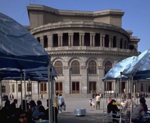
- The Yerevan Opera Theatre or, to give it's full title, The Alexander Spendiarian Armenian Opera and Ballet National Academic Theatre was officially opened on 20 January 1933. The building was designed by the Armenian architect Alexander Tamanian. The building consists of two concert halls: Aram Khatchaturian concert hall and the hall of the Alexander Spendiarian Opera and Ballet National Theatre. The ground-breaking of the Opera-Theatre took place on 28 November 1930 during the celebrations of the 10th anniversary of Soviet Armenia. On January 20, 1933, the building was officially opened. Soon after the theatre foundation, a ballet troupe was established. Swan Lake by Pyotr Ilyich Tchaikovsky was the first ballet performance in 1935. In 1938, the theatre was named after Alexander Spendiaryan, great Armenian composer, author of opera Almast which was performed in 1933 as a first performance at the theatre. The 2nd phase of the construction was completed in 1940 according to Tamanian's design and under the supervision of his son. Large-scale construction works were applied until 1953, when the building was finally completed with its current shape.
- The Cascade is a giant stairway that links the downtown Kentron area of Yerevan with the Monument neighborhood. Inside the Cascade, underneath the exterior steps is an escalator going the length of the complex. There are also rooms connected to some of the landings along the escalators which comprise the Cafesjian Museum of Art. The exterior of Cascade, in addition to stairs has multiple levels with fountains and sculptures. The stairs afford walkers unobstructed views of central Yerevan and Mount Ararat. Construction began during Soviet rule, but stopped with the chaos that accompanied the disintegration of the USSR. The complex was purchased by an American-Armenian businessman Gerard Cafesjian in the early 2000s and a complete renovation was performed. A large museum complex was also planned for the top. Although construction began, it was frozen in the early stages and has not continued for years.
- Erebuni Fortress also known as Arin Berd meaning the "Fortress of Blood" is a fortified city from the ancient kingdom of Urartu, located in what is present-day Yerevan. It was one of several fortresses built along the northern Urartian border and was one of the most important political, economic and cultural centers of the vast kingdom. The name Yerevan itself is derived from Erebuni. Erebuni was founded by King Argishti I (r. ca. 785–753 B.C.) in 782 B.C. It was built on top of a hill called Arin Berd overlooking the Arax River Valley to serve as a military stronghold to protect the kingdom's northern borders. According to Margarit Israelyan, Argishti began the construction of Erebuni after conquering the territories north of Yerevan and west of Lake Sevan, roughly corresponding to where the town of Abovyan is currently located. Accordingly, the prisoners he captured in these campaigns, both men and women, were used to help build his town.


York

York was founded by the Romans in 71 AD, under the name of Eboracum. It became in turn the capital of the Roman province of Britannia Inferior, and of the kingdoms of Northumbria and Jorvik. In the Middle Ages, York grew as a major wool trading centre and became the capital of the northern ecclesiastical province of the Church of England, a role it has retained.
The Emperors Hadrian, Septimius Severus and Constantius I all held court in York during their various campaigns. During his stay, the Emperor Severus proclaimed York capital of the province of Britannia Inferior, and it is likely that it was he who granted York the privileges of a colonia or city. Constantius I died in 306 AD during his stay in York, and his son Constantine the Great was proclaimed Emperor by the troops based in the fortress.

If you are looking for a cultural getaway, romantic short break, relaxing UK holiday or family day out then visit York and be inspired. Renowned for its exquisite architecture, tangle of quaint cobbled streets and the iconic York Minster, York is fast developing a flourishing, cutting-edge scene. Delve into the city's vibrant café culture, take time out to enjoy some of the country's most talented street entertainers or simply watch the world go by while sipping a drink by the river. A city of contrasts and exciting discoveries, York is a place where the old encompasses the new and the commonplace meets with the unexpected. Broaden your mind with a visit to world class museums or a variety of festivals held throughout the year catering for all ages and interests.
The best way to see York is to set off and walk, every turn will bring you to a new gate or bar steeped in history. Goodramgate, Swinegate, Fossgate, Petergate, Monk Bar, all have a tale to tell.
 |
| The Shambles |
The most famous street in York is The Shambles, with it's overhanging timber-framed buildings, some dating back as far as the fourteenth century. It was once known as The Great Flesh Shambles, probably from the Anglo-Saxon Fleshammels (literally 'flesh-shelves'), the word for the shelves that butchers used to display their meat. As recently as 1872 there were twenty-five butchers' shops in the street but now there are none. There is still a butcher in the adjacent Little Shambles which leads to York's open-air Newgate Market. Among the buildings of the Shambles is a shrine to Saint Margaret Clitherow, who was married to a butcher who owned and lived in a shop there.
Old buildings abound in Goodramgate, including the oldest row of houses in York - and possibly the country. Lady Row dates from the 14th century and today houses a selection of tiny shops. Between the shops are various small alleyways, including Bedern leading to Bedern Hall; College Street, at the junction of Goodramgate and Deangate, leading to St William's College; Ogleforth and another turning, Aldwark, leading to the Merchant Taylor's Hall.
Historic Fossgate runs from Pavement down to the River Foss and the start of Walmgate. It was once known as Tricksters Lane after the unscrupulous traders who set up shop there. The area now known as the Swinegate Quarter is home to numerous shops, galleries and trendy bars and restaurants. Grape Lane is one of the oldest streets in the city, although it had an unsavoury reputation in medieval times, when it was called Grope Lane and the home of York's ladies of the night (despite most of the properties being owned by the Church!). Now it is a well-heeled street with quality shops and restaurants. A tablet on a wall in Stonegate shows where Guy Fawkes spent part of his life. The colourful front on number 10 is a testimony to the art of the tiler from another time. A sign to Stonegate Gallery also leads down a narrow alleyway to the remains of a Norman 12th century house.
In the centre of York, in St Helen’s Square, there is the York branch of Bettys Café Tea Rooms. Bettys founder, Frederick Belmont, travelled on the maiden voyage of the Queen Mary in 1936. He was so impressed by the splendour of the ship that he employed the Queen Marys’ designers and craftsmen to turn a dilapidated furniture store in York into an elegant café in St Helen’s Square. A few years after Bettys opened in York war broke out, and the basement ‘Bettys Bar’, became a favourite haunt of the thousands of airmen stationed around York. ‘Bettys Mirror’, on which many of them engraved their signatures with a diamond pen, remains on display today as a tribute to them.
.jpg)
York’s Top 5:
 |
| Micklegate Bar |
- York Minster. One of the largest Cathedrals of its kind in Northern Europe alongside Cologne Cathedral. The minster is the seat of the Archbishop of York, the second-highest office of the Church of England, and is the cathedral for the Diocese of York. The first recorded church on the site was a wooden structure built hurriedly in 627 to provide a place to baptise Edwin, King of Northumbria. Moves toward a more substantial building began in the 630s. A stone structure was completed in 637 by Oswald and was dedicated to Saint Peter.
- The City Walls. Over a million people a year take a walk through 1900 years of history on York's city walls. Built in Roman times, they've been added to and rebuilt over time and now have parts from across the centuries. Originally built as defences, the focus is now on conservation. Along the walls, many old gates or 'bars' remain intact.
- Jorvik Centre. At JORVIK Viking Centre you are standing on the site of one of the most famous and astounding discoveries of modern archaeology. Thirty years ago the archaeologists from York Archaeological Trust revealed the houses, workshops and backyards of the Viking-Age city of Jorvik, as it stood 1,000 years ago. They removed eights tonnes of rubble and over 40,000 artefacts! York Archaeological Trust then built the JORVIK Viking Centre on the very site where the excavations had taken place, creating a groundbreaking visitor experience that changed the face of museums. Their determination to recreate a Viking city as authentically as possible from the layout of the houses, the working craftsmen, the language of the gossiping neighbours, to the smells of cooking and the cesspit meant it has now been visited by more than 15 million people during its 25 years of opening.
- York Castle/Clifford's Tower. A fortified complex comprising, over the last nine centuries, a sequence of castles, prisons, law courts and other buildings on the south side of the River Foss. The now-ruinous keep of the medieval Norman castle is sometimes referred to as Clifford's Tower. Built originally on the orders of William I to dominate the former Viking city of York, the castle suffered a tumultuous early history before developing into a major fortification with extensive water defences. After a major explosion in 1684 rendered the remaining military defences uninhabitable, York Castle continued to be used as a jail and prison until 1929.
- The Shambles is a narrow medieval street, lined with shops, boutiques and tea rooms. Most of these premises were once butchers' shops, and the hooks from which carcasses were hung and the shelves on which meat was laid out can still be seen outside some of them.
 |
| Clifford's Tower |
Ypres

Ypres is a Belgian municipality located in the Flemish province of West Flanders. Though Ieper is the Dutch and local name, Ypres is most commonly used in English. The municipality comprises the city of Ypres and the villages of Boezinge, Brielen, Dikkebus, Elverdinge, Hollebeke, Sint-Jan, Vlamertinge, Voormezele, Zillebeke, and Zuidschote. Together, they count some 34,900 inhabitants.
Ypres is an ancient town, known to have been raided by the Romans in the first century BC.
During the Middle Ages, Ypres was a prosperous Flemish city with a population of 40,000, renowned for its linen trade with England, which was mentioned in the Canterbury Tales.
During the Middle Ages, Ypres was a prosperous Flemish city with a population of 40,000, renowned for its linen trade with England, which was mentioned in the Canterbury Tales.

As the third largest city in the County of Flanders (after Ghent and Bruges) Ypres played an important role in the history of the textile industry. Textiles from Ypres could be found on the markets of Novgorod in Russia in the early 12th century. In 1241 a major fire ruined much of the old city. The powerful city was involved in important treaties and battles, including the Battle of the Golden Spurs, the Battle at Pevelenberg, The Peace of Melun and the Battle of Cassel.
The famous Cloth Hall was built in the thirteenth century. Also during this time cats, then the symbol of the devil and witchcraft, were thrown off Cloth Hall, possibly due to the belief that this would get rid of evil demons. Today, this act is commemorated with a triennial Cat Parade through town.
After the destruction of Thérouanne, Ypres became the seat of the new Diocese of Ypres in 1561, and Saint Martin's Church was elevated to cathedral status.
During the Norwich Crusade, led by the English bishop Henry le Despenser, Ypres was besieged from May to August 1383, until French relief forces arrived. On 25 March 1678 Ypres was conquered by the forces of Louis XIV of France. It remained French under the treaty of Nijmwegen and Vauban constructed his typical fortifications, that can still be seen today. In 1697, after the Treaty of Ryswick, Ypres was returned to the Spanish Crown.

During the War of the Spanish Succession, the Duke of Marlborough in 1709 intended to capture Ypres, at the time a major French fortress, but changed his mind due to the long time and effort it had taken him to capture Tournai and apprehension of disease spreading in his army in the poorly drained land around Ypres. In 1713 it was handed over to the Habsburgs, and became part of the Austrian Netherlands.
In 1782 the Austrian emperor Joseph II ordered parts of the walls torn down, making it easy for the French to take over the city during the first coalition war in 1794.
Ypres had long been fortified to keep out invaders. Parts of the early ramparts, dating from 1385, still survive near the Rijselpoort (Lille Gate). Over time, the earthworks were replaced by sturdier masonry and earth structures and a partial moat. Ypres was further fortified in 17th and 18th centuries while under the occupation of the Habsburgs and the French. Major works were completed at the end of the 17th century by the French military engineer Sebastien Le Prestre, Seigneur de Vauban.
Ypres occupied a strategic position during World War I because it stood in the path of Germany's planned sweep across the rest of Belgium and into France from the north (the Schlieffen Plan). The neutrality of Belgium was guaranteed by Britain; Germany's invasion of Belgium brought the British Empire into the war. The German army surrounded the city on three sides, bombarding it throughout much of the war. To counterattack, British, French, and allied forces made costly advances from the Ypres Salient into the German lines on the surrounding hills.
 |
| Menin Gate |
In the First Battle of Ypres (12 October to 11 November 1914), the Allies captured the town from the Germans. The Germans had used tear gas at the Battle of Bolimov on 3 January 1915. Their use of poison gas for the first time the on 22 April 1915 marked the beginning of the Second Battle of Ypres, which continued until 25 May 1915. They captured high ground east of the town. The first gas attack occurred against Canadian, British, and French soldiers; including both metropolitan French soldiers as well as Senegalese and Algerian tirailleurs (light infantry) from French Africa. The gas used was chlorine. Mustard gas, also called Yperite from the name of this city, was also used for the first time near Ypres, in the autumn of 1917.

English-speaking soldiers in that war often referred to Ieper/Ypres by the deliberate mispronunciation Wipers. British soldiers even published a wartime newspaper called the Wipers Times. The same style of deliberate mispronunciation was applied to other Flemish place names in the Ypres area for the benefit of British troops, such as Whyteshaete becoming White Sheet and Ploegsteert becoming Plug Street.
Today, Ypres is a small city in the very western part of Belgium, the so-called Westhoek. Ypres these days has the title of "city of peace" and maintains a close friendship with another town on which war had a profound impact: Hiroshima. Both towns witnessed warfare at its worst: Ypres was one of the first places where chemical warfare was employed, while Hiroshima suffered the debut of nuclear warfare. The city governments of Ypres and Hiroshima advocate that cities should never be targets again and campaign for the abolition of nuclear weapons. The City of Ypres hosts the international campaign secretariat of Mayors for Peace, an international Mayoral organization mobilizing cities and citizens worldwide to abolish and eliminate nuclear weapons by the year 2020. Mayors for Peace 2020 Vision Campaign.

Ypres was one of the sites that hosted an unofficial Christmas Truce in 1914 between German and British soldiers.
After the war the town was rebuilt using money paid by Germany in reparations, with the main square, including the Cloth Hall and town hall, being rebuilt as close to the original designs as possible (the rest of the rebuilt town is more modern in appearance). The Cloth Hall today is home to In Flanders Fields Museum, dedicated to Ypres's role in the First World War.
Today, Ypres is a small city in the very western part of Belgium, the so-called Westhoek. Ypres these days has the title of "city of peace" and maintains a close friendship with another town on which war had a profound impact: Hiroshima. Both towns witnessed warfare at its worst: Ypres was one of the first places where chemical warfare was employed, while Hiroshima suffered the debut of nuclear warfare. The city governments of Ypres and Hiroshima advocate that cities should never be targets again and campaign for the abolition of nuclear weapons. The City of Ypres hosts the international campaign secretariat of Mayors for Peace, an international Mayoral organization mobilizing cities and citizens worldwide to abolish and eliminate nuclear weapons by the year 2020. Mayors for Peace 2020 Vision Campaign.

Ypres’ Top 5:
- Saint Martin's Cathedral or Saint Martin's Church was a cathedral and the seat of the former diocese of Ypres from 1561 to 1801. Although no longer a technically a cathedral, it is still often referred to as one, as is the case with many proto-cathedrals. At 102 metres (335 ft) tall, it is among the tallest buildings in Belgium. Construction started on the church in 1230, and was finished in 1370. There had previously been a Romanesque church in the area, dating from the 10th or 11th century. The diocese was originally part of the Diocese of Thérouanne, which had been established in the 7th or 8th century. In 1553 Charles V besieged the city of Thérouanne, then a French enclave in the Holy Roman Empire, in revenge for a defeat by the French at Metz. After he captured the city he razed the city. In 1557, as a result of the war damage to its see, the diocese was abolished. This led to a reform of sees at the Council of Trent, Council of Trent, and the bishopric of Thérouanne was split between the Diocese of Saint-Omer, the diocese of Boulogne and the Diocese of Ypres. With this, Saint Martin's Church was elevated to cathedral status, as it became the see of the new diocese.
- The Menin Gate Memorial to the Missing is a war memorial dedicated to the British and Commonwealth soldiers who were killed in the Ypres Salient of World War I and whose graves are unknown. The memorial is located at the eastern exit of the town and marks the starting point for one of the main roads out of the town that led Allied soldiers to the front line. Designed by Sir Reginald Blomfield and built by the British government, the Menin Gate Memorial was unveiled on 24 July 1927. The memorial's location is especially poignant as it lies on the eastward route from the town which allied soldiers would have taken towards the fighting – many never to return.
- The In Flanders' Fields Museum is devoted to the study of World War I and occupies the second floor of the Cloth Hall. The curator, Piet Chielens, is a World War I historian. The museum is named for the famous poem by Canadian John McCrae. Visitors to the museum will find no glorification of war; rather the museum suggests the futility of war, especially as seen in Flanders in World War I. Following a closure for refurbishments, the museum has reopened in June 2012. The renovation goes well beyond a new layout and embellishments, and is aimed at providing visitors with a more intense perception and richer experience. It also presents a general introduction to WWI in Flanders with reference to other sites and museums, and is intented to encourage the visitor to view the actual sites for themselves. The museum includes a new WWI research centre.
- Saint George's Memorial Church was built to commemorate over 500,000 British and Commonwealth troops, who had died in the three battles fought for the Ypres Salient, during World War I. The church was built following an appeal led by The Ypres League and its President Field Marshal Sir John French, Earl of Ypres, for a British memorial church to be built. Land was given by the town, and the foundation stone was laid by Field Marshal Lord Plumer on July 24, 1927. The church was consecrated by the Bishop of Fulham on March 24, 1929.
- The Cloth Hall of Ypres was one of the largest commercial buildings of the Middle Ages, when it served as the main market and warehouse for the Flemish city's prosperous cloth industry. The original structure, erected mainly in the 13th century and completed 1304, lay in ruins after artillery fire devastated Ypres in World War I. Between 1933 and 1967, the hall was meticulously reconstructed to its prewar condition, under the guidance of architects J. Coomans and P.A. Pauwels. At 125 metres in breadth, with a 70-metre-high belfry tower, the Cloth Hall recalls the importance and wealth of the medieval trade city.


Zadar

Zadar is a city in Croatia on the Adriatic Sea. It is the centre of Zadar County and the wider northern Dalmatian region. Zadar is a historical center of Dalmatia as well as the seat of the Roman Catholic Archdiocese of Zadar.
The district of present day Zadar has been populated since prehistoric times. The earliest evidence of human life comes from the Late Stone Age, while numerous settlements have been dated as early as the Neolithic. Before the Illyrians, the area was inhabited by an ancient Mediterranean people of a pre-Indo-European culture. They assimilated with the Indo-Europeans who settled between the 4th and 2nd millennium BC into a new ethnical unity, that of the Liburnians. Zadar was a Liburnian settlement, laid out in the 9th century BC, built on a small stone islet and embankments where the old city stands and tied to the mainland by the overflown narrow isthmus, which created a natural port in its northern strait.

The people of Zadar, the Iadasinoi, were first mentioned in 384 BC as the allies of the natives of Hvar and the leaders of an eastern Adriatic coast coalition in the fight against the Greek colonizers. An expedition of 10,000 men in 300 ships sailed out from Zadar and laid siege to the Greek colony Pharos in the island of Hvar, but the Syracusan fleet of Dionysus was alerted and attacked the siege fleet. The naval victory went to the Greeks which allowed them relatively safer further colonization in the southern Adriatic.
In the 5th century, under the rule of the Ostrogothic Kingdom, Zadar became poor with many civic buildings turning into ruins due to its advanced age. About the same time (6th century) it was hit by an earthquake, which destroyed entire complexes of monumental Roman architecture, whose parts would later serve as material for building houses. This caused a loss of population and created demographic changes in the city, then gradually repopulated by the inhabitants from its hinterland. However, during six decades of Gothic rule, the Goths saved those old Roman Municipal institutions that were still in function, while religious life in Dalmatia even intensified in the last years, so that there was a need for the foundation of additional bishoprics.

In 536 the Byzantine emperor Justinian the Great started a military campaign to reconquer the territories of the former Western Empire and in 553 Zadar passed to the Byzantine Empire. In 568 Dalmatia was devastated by an Avar invasion; although further waves of attacks by Avar and Slav tribes kept up the pressure, it was the only city which survived due to its protective belt of inland plains. The Dalmatian capital Salona was captured and destroyed in the 40s of the 7th century, so Zadar became the new seat of the Byzantine archonty of Dalmatia, territorially reduced to a few coastal cities with their agers and municipal lands at the coast and the islands nearby. The prior of Zadar had jurisdiction over all Byzantine Dalmatia, so Zadar enjoyed metropolitan status at the eastern Adriatic coast. At this time rebuilding began to take place in the city.

During 1918, political life in Zara intensified. The collapse of the Austro-Hungarian Monarchy led to the renewal of national conflicts in the city. With the arrival of an Italian army of occupation in the city on 4 November 1918, the Italian faction gradually assumed control, a process which was completed on 5 December when it took over the governorship. With the Treaty of Versailles (10 January 1920) Italian claims on Dalmatia contained in the Treaty of London were nullified, but later on the agreements between the Kingdom of Italy and the Kingdom of Serbs, Croats and Slovenes set in the Treaty of Rapallo (12 November 1920) gave Zara with other small local territories to Italy.


During the Croatian War of Independence, Krajina rebels and the Yugoslav People's Army (JNA) (at the time under Slobodan Milošević's control) converged on the city and subjected it to artillery bombardment during Operation Coast-91 in which they tried to take control of northern Dalmatia. Along with other Croatian towns in the area, Zadar was shelled sporadically for several years, resulting in damage to buildings and homes as well as UNESCO protected sites. A number of nearby towns and villages were also attacked, the most brutal being the Škabrnja massacre in which 86 people were killed.
Connections with Zagreb were severed for over a year. The only link between the north and south of the country was via the island of Pag. The siege of the city lasted from 1991 until January 1993 when Zadar and the surrounding area came under the control of Croatian forces and the bridge link with the rest of Croatia was reestablished in Operation Maslenica. Attacks on the city continued until the end of the war in 1995.
After the fall of Venice in 1797 and with the Treaty of Campo Formio, Zadar came under the Austrian crown and was united with the rest of Croatia. In 1806 it was briefly given to the Napoleonic Kingdom of Italy, until in 1809 it was added to the French Illyrian Provinces. In 1813, all of Dalmatia was reconquered and brought back under the control of the Austrian Empire. During this time, it maintained its position as the capital of Dalmatia.
During the 19th century, the conflict between Zadar's Italian and Croatian communities grew in intensity and changed its nature. Until the beginning of the century it had been of moderate intensity and mainly of a class nature (under Venetian rule the Italians were employed in the most profitable activities, such as trade and administration). With the development of the modern concept of national identity across Europe, national conflicts start to mark the political life of Zadar.

In 1915 Italy entered World War I under the provisions set in the Treaty of London. In exchange for its participation with the Triple Entente and in the event of victory, Italy was to obtain the following territory in northern Dalmatia, including Zara, Sebenico and most of the Dalmatian islands, except Krk and Rab. At the end of the war, Italian military forces invaded Dalmatia and seized control of Zara, with Admiral Enrico Millo being proclaimed the governor of Dalmatia. Famous Italian nationalist Gabriele d'Annunzio supported the seizure of Dalmatia, and proceeded to Zara in an Italian warship in December 1918.
During 1918, political life in Zara intensified. The collapse of the Austro-Hungarian Monarchy led to the renewal of national conflicts in the city. With the arrival of an Italian army of occupation in the city on 4 November 1918, the Italian faction gradually assumed control, a process which was completed on 5 December when it took over the governorship. With the Treaty of Versailles (10 January 1920) Italian claims on Dalmatia contained in the Treaty of London were nullified, but later on the agreements between the Kingdom of Italy and the Kingdom of Serbs, Croats and Slovenes set in the Treaty of Rapallo (12 November 1920) gave Zara with other small local territories to Italy.
Germany, with limited Italian assistance, invaded the Kingdom of Yugoslavia on April 6, 1941. Zadar held a force of 9,000 that after limited fighting reached Šibenik and Split on April 15, a mere 2 days before surrender, with civilians having previously been evacuated to Ancona and Pula. Occupying Mostar and Dubrovnik, on April 17 they met invading troops that had started out from Italian-occupied Albania. On April 17 the Yugoslav government surrendered, faced with the Wehrmacht's overwhelming superiority.

Within a few weeks, Benito Mussolini required the newly formed Nazi puppet-state, the so-called Independent State of Croatia (NDH) to hand over almost all of Dalmatia (including Split) to fascist Italy under the Treaty of Rome.
The city became the centre of a new Italian territorial entity, called Governorship of Dalmatia, including the provinces of Zadar, Split and Kotor.
After Mussolini was removed from power on 25 July 1943 and arrested, the government of Pietro Badoglio signed an armistice with the Allies on 3 September 1943, which was made public only on 8 September 1943, and the Italian army collapsed. However, just four days later on 12 September 1943, "Il Duce", was rescued by a German military raid from his secret prison on the Gran Sasso mountain, and formed the Nazi-puppet Italian Social Republic in the north of the Country. The NDH proclaimed the Treaty of Rome to be void and occupied Dalmatia with German support. The Germans entered Zadar first, and on September 10 the German 114th Jäger Division took over. This avoided a temporary liberation by Partisans, as was the case in Split and Šibenik where several Italian fascist government officials were killed by an angry crowd.
The city was prevented from joining the NDH on the grounds that Zadar itself was not subject to the conditions of the Treaty of Rome. Despite this, the NDH's leader Ante Pavelić designated Zadar as the capital of the Sidraga-Ravni Kotari County, although its administrator was prevented from entering the city. Zadar remained under the local administration of the Italian Social Republic. Zadar was bombed by the Allies, with serious civilian casualties. Many died in the carpet bombings, and many landmarks and centuries old works of art were destroyed. A significant number of civilians fled the city.
In late October 1944 the German army and a significant amount of the civilian population abandoned the city. On October 31, 1944, the Partisans seized the city, until then a part of Mussolini's Italian Social Republic. Formally, the city remained under Italian sovereignty until September 15, 1947 (Paris Peace Treaties). The Italian exodus from the city continued and in a few years was almost total. The last stroke to the Italian presence was made by the local administration in October 1953, when the last Italian schools were closed and the students forced to move, in one day, into Croatian schools, putting an end to the Romance identity of the city. Today the Italian community counts only a few hundreds people, gathered into a local community (Comunita' degli Italiani di Zara).

In the early 1990s the Yugoslav wars broke out. Zadar became a part of the new Republic of Croatia. Its economy suffered greatly at this time not only because of the war but also due to the shadowy and controversial privatization process, which caused most of its prosperous companies to go under.
During the Croatian War of Independence, Krajina rebels and the Yugoslav People's Army (JNA) (at the time under Slobodan Milošević's control) converged on the city and subjected it to artillery bombardment during Operation Coast-91 in which they tried to take control of northern Dalmatia. Along with other Croatian towns in the area, Zadar was shelled sporadically for several years, resulting in damage to buildings and homes as well as UNESCO protected sites. A number of nearby towns and villages were also attacked, the most brutal being the Škabrnja massacre in which 86 people were killed.
Connections with Zagreb were severed for over a year. The only link between the north and south of the country was via the island of Pag. The siege of the city lasted from 1991 until January 1993 when Zadar and the surrounding area came under the control of Croatian forces and the bridge link with the rest of Croatia was reestablished in Operation Maslenica. Attacks on the city continued until the end of the war in 1995.

Zadar’s Top 5:
- The Cathedral of St. Anastasia is a Roman Catholic cathedral, the seat of the Archdiocese of Zadar, and the largest church in all of Dalmatia. The church's origins date back to a Christian basilica built in the 4th and 5th centuries, while much of the currently standing building was constructed in the Romanesque style during the 12th and 13th centuries. The site has been submitted to UNESCO's Tentative List of World Heritage Sites. The first known bishop in Zadar was Felix - he attended two church councils, the first in Aquileia in 381 and the second in Milan in 390. The basilica's original patron was St. Peter. During the time of bishop Donatus, the diocese received the ashes of St. Anastasia of Syrmia from Emperor Nikephoros I, whom the cathedral took as patron. Donatus commissioned a sarcophagus for the remains, which are still held in the cathedral. During the siege of Zadar by the Venetians and Crusaders in 1202, the cathedral was heavily damaged. For the entire 13th century the building was under repair. Over the cathedral's history, two popes have made personal visits. Pope Alexander III arrived in 1177 and visited the cathedral as well as St. Anastasia's sarcophagus. Pope John Paul II came to the cathedral on June 9, 2003 on one of his last international visits.
- The Sea organ is an architectural object and an experimental musical instrument which plays music by way of sea waves and tubes located underneath a set of large marble steps. The waves create somewhat random but harmonic sounds. The device was made by the architect Nikola Bašić as part of the project to redesign the new city coast (Nova riva), and the site was opened to the public on 15 April 2005.
- National Museum [Narodni muzej Zadar] The Zadar branch of the National Museum traces the urban development of Zadar from the Baroque to the first half of the 19th century: architectural fragments, portraiture, furniture and (particularly recommended) early photography. There are also scale models of Zadar through the ages. The scientific section of the National Museum is kept in the Deputy's Palace. The Zadar National Museum consists of the Zadar City Museum, the Natural Science Department and the Ethnological Department.
- The Captain's Tower [Kapetanova kula] A pentagonal tower on the Five Wells Square, built by the Venetians to strengthen the city against Turkish attacks. It gets its name from the nearby residence of the Venetian city captain, and is now used as an exhibition space.
- St Donatus' Church - a monumental round building from the 9th century in pre-Romanesque style, traditionally but erroneously said to have been erected on the site of a temple of Juno. It is the most important preserved structure of its period in Dalmatia; the massive dome of the rotunda is surrounded by a vaulted gallery in two stories which also extends around the three apses to the east. The church treasury contains some of the finest Dalmatian metalwork; notably the pastoral staff of Bishop Valaresso (1460). It is pretty difficult to miss, as it has become the most recognizable symbol of Zadar. The church is no longer in use for religious ceremonies, and today is a museum. It also holds a series of classical music concerts every summer.


Zagreb

Zagreb, capital of the Republic of Croatia is also its largest city and the cultural, economic, cinematic, sporting and governmental hub of the country. It is located on the southern slopes of the Medvednica Mountain along the banks of the Sava River. Culturally, it is a very old and traditional European city, with its numerous historical monuments and a long cultural history reminding of the times gone by. It favorable geographic positioning on the Pannonian Basin gives it an instant access to Central Europe and the Adriatic coast. Maybe that’s why, for many years, it has remained the economic gateway connecting Central and Western Europe via the Adriatic Sea.

During the period of former Yugoslavia, Zagreb established itself as an important economic centre of the country, and was the second largest city.
When Croatia achieved independence in 1991, Zagreb was declared it capital and along with it came the political and administrative responsibilities. Today, the city has maintained its medieval structure in the Gradec and Kaptol area which are prime administrative regions of the city.
Today, it is the only city in Croatia with a population of over one million. Yet as the city advances into the new millennium, it has retained its old charisma and its welcoming attitude towards its visitors.
There are many interesting things for tourists in Zagreb, for example, the two statues of Saint George, one at the Marshal Tito Square, the other at Kamenita vrata, where the image of Virgin Mary is said to be only thing that didn't burn in the 17th century fire. Also, there is an art installation starting in Bogovićeva street, called Nine Views. Most of the people don't know what the statue Prizemljeno sunce (The Grounded Sun) is for, so they put graffiti or signatures on it, but it's actually the Sun scaled down, with many planets situated all over Zagreb in relative scale with the Sun.
When Croatia achieved independence in 1991, Zagreb was declared it capital and along with it came the political and administrative responsibilities. Today, the city has maintained its medieval structure in the Gradec and Kaptol area which are prime administrative regions of the city.
Today, it is the only city in Croatia with a population of over one million. Yet as the city advances into the new millennium, it has retained its old charisma and its welcoming attitude towards its visitors.
 |
| The Grounded Sun |
Bana Jelačić Square officially known as the Trg Bana Jelačića is the central square of the city, named after ban Josip Jelačić. People simply call it Jelacic Square. It is located in Zagreb’s upper town area, south of Dolac market. The square marks the intersection of many streets such as Illica and Radićeva and small streets such as Splavnica, Harmica, Bakačeva, Jurišićeva and Gajeva. The square is marked as a pedestrian zone and therefore no vehicles are allowed inside the area. But it is accessible by tram.
The historical part of the city to the north of Ban Jelačić Square is composed of the Gornji Grad and Kaptol, a medieval urban complex of churches, palaces, museums, galleries and government buildings that are popular with tourists on sightseeing tours. The historic district can be reached on foot, starting from Jelačić Square, the center of Zagreb, or by a funicular on nearby Tomićeva Street.
Numerous shops, boutiques, store houses and shopping centers offer a variety of quality clothing. Zagreb's offerings include crystal, china and ceramics, wicker or straw baskets, and top-quality Croatian wines and foodstuffs.

Notable Zagreb souvenirs are the tie or cravat, an accessory named after Croats who wore characteristic scarves around their necks in the Thirty Years' War in the 17th century and the ball-point pen, a tool developed from the inventions by Slavoljub Eduard Penkala, an inventor and a citizen of Zagreb.
Many Zagreb restaurants offer various specialities of national and international cuisine. Domestic products which deserve to be tasted include turkey, duck or goose with mlinci (a kind of pasta),štrukli (cottage cheese strudel), sir i vrhnje (cottage cheese with cream), kremšnite (custard slices in flaky pastry), and orehnjača (traditional walnut roll).
Zagreb’s Top 5:
 |
| Katedrala Marijina Uznesenja |
- Cathedral of the Assumption of the Blessed Virgin Mary. Formerly known as St.Stephen's Cathedral, The Cathedral of the Assumption of the Blessed Virgin Mary is locally known as Katedrala Marijina Uznesenja. The twin spires of the Cathedral make it the most visited attraction in Zagreb. The first Cathedral was destroyed during the Tartar attack in the 13th century and the present cathedral was built during the latter part of the 13th century. But what we see today is what not was originally built, as many renovations have completely restructured the construction. The main reason behind the reconstruction was the immense damage done by the earthquake in 1880, completely destroying the dome and bell tower. But later alterations have retained the medieval design.
- The Tower of Lotrscak. (Kula Lotrscak) is a fortification tower built in the 13th century to protect Gradec's southern town wall. Once upon a time, the tower included a bell which rang during the night when all gates were supposed to be closed. Once the gates were closed the people who were left outside will have to remain there till the next sunrise. In the 19th century, additions were made to the tower in the form of an additional fourth floor and a canon which is even today is fired every noon and now is used to set watches. You can get to see a stunning view of the city once you climb the tower. Atop there is an exhibition gallery and a gift shop.
- The Mimara Museum. It is situated at the Roosevelt Square, housing the collection by Wiltrud and Ante Topić Mimara. Its full official name is the "Art Collection of Ante and Wiltrud Topić Mimara". Of the total of 3,700 varied works of art, more than 1,500 exhibits constitute permanent holdings, dating from the prehistoric period up to the 20th century. Some of the most famous exhibits include works by Lorenzetti, Raffaello, Giorgione, Veronese, Caravaggio and Canaletto,
- Mirogoj Cemetery. Located a little away from Zagreb city centre, but easily accessible by public transport is the beautiful and 'heavenly' Mirogoj Cemetery. Designed by Hermann Bollé in 1876, at the base of Mount Medvednica, the cemetery is counted among the top 10 cemeteries of Europe. The look of the cemetery doesn't seem to be spooky, but instead reminds us of a Neo-Renaissance castle with its vine covered walls, arcades, chapels; ornate structures and greenery spread around 7 acres of its space. Many distinguished families and personas of Croatia are buried here like Petar Preradovic and Stjepan Radic.
- St Mark's Church. The Romanesque window found in its south facade is the best evidence that the church must have been built as early as the 13th century as is also the semicircular groundplan of St. Mary's chapel (later altered). In the second half of the 14th century the church was radically reconstructed. It was then turned into a late Gothic church of the three-nave type.

St Mark's Church

References: http://www.zagreb.com/v/city_info/
Zamora

Zamora is a city in Castile and León, Spain, the capital of the province of Zamora. It lies on a rocky hill in the northwest, near the frontier with Portugal and crossed by the Duero river, which is some 50 km downstream as it reaches the Portuguese frontier. Zamora is the city with the most Romanesque churches in all of Europe.
After the Roman victory over the Lusitanian hero Viriathus the settlement was named by the Romans, Occelum Durii or Ocellodurum (literally, "Eye of the Duero"). During Roman rule it was in the hands of the Vaccaei, and was incorporated into the Roman province of Hispania Tarraconensis.

Two coins from the reign of the Visigothic king, Sisebuto, show that it was known at the time as "Semure".
During the period of Moorish rule the settlement became known by the names of "Semurah" or "Azemur". After the establishment of the Christian Kingdom of Asturias, the settlement became a strategic frontier post and was the scene of many fierce military engagements between the Muslims and Christians. Control of the town shifted between the two sides a number of times from the early eighth century to the late eleventh century. During this period it became heavily fortified.
During the period of Moorish rule the settlement became known by the names of "Semurah" or "Azemur". After the establishment of the Christian Kingdom of Asturias, the settlement became a strategic frontier post and was the scene of many fierce military engagements between the Muslims and Christians. Control of the town shifted between the two sides a number of times from the early eighth century to the late eleventh century. During this period it became heavily fortified.
The most notable historic episode in Zamora was the assassination outside the city walls of the king Sancho II of Castile in 1072. Some decades before, king Ferdinand I of León had divided his kingdoms between his three sons. To his daughter, Doña Urraca, he had bequeathed the "well fortified city of Zamora" (or "la bien cercada" in Spanish). All three sons warred among themselves, till the ultimate winner, Sancho, was left victorious. Zamora, under his sister who was allied with Leonese nobles, resisted. Sancho II of Castile, assisted by El Cid, lay siege to Zamora. King Sancho II was murdered by a duplicitous noble of Zamora, Bellido Dolfos, who tricked the king into a private meeting. After the death of Sancho, Castile reverted to his deposed brother Alfonso VI of León. The event was commemorated by the Portillo de la Traición (Treason Gate). Zamora was also the scene of fierce fighting in the fifteenth century, during the conflict between the supporters of Isabella the Catholic and Juana la Beltraneja. The Spanish proverb, No se ganó Zamora en una hora, literally, Zamora wasn't won in an hour, is a reference to these battles. It is the Spanish equivalent of the English proverb "Rome wasn't built in a day."

During the 12th century, the city was extraordinarily important for its strategic position in the wars between the Kingdom of León and Arabs to conquer the Iberian Peninsula. As a result, the city preserves many churches and buildings from that time. In the next centuries, the city lost its political and economic relevance and suffered emigration, especially to South America (where many other cities called Zamora were founded).
Typical souvenirs include items featuring elements from Semana Santa or Easter. Local wines and cheese, as well as chickpeas from Fuentesaúco always make a good buy. If you're more into the vintage-style buying, check out the weekly mercadillo, a street market held every Tuesday morning. The traditional site was just outside the Train Station, now moved to the parking lot of the Football Stadium Vía de la Plata (either a good 30 minute walk from downtown Zamora or one of the only occasions where local transport would be worth it). The mercadillo is set to return to its original location outside the Estación del Ferrocarril, but no deadline has been given as of May 2007.

If you happen to visit Zamora at the end of June, pottery would make an excellent souvenir too, as Viriathus Square is filled with stands from all over the country selling their creations. You can find items both for everyday use and for display. The 'big day' of the San Pedro festivity is June 29th. You can buy some of these products and other souvenirs, cheese or wine at the store Aperos y Viandas (literally "Farming implements and Food") which is on the way to the Cathedral or at some the shops in and around Ramos Carrión Square. These cater especially for tourists, but you can find many local products -especially wine-at any supermarket (Mercadona, El Arbol, Eroski, etc).

The excellent raw materials used in the local cuisine really stand out. Staple ingredients include the pulses, the famous chickpeas from Fuentesauco or 'garbanzos', the exquisite cheese made from sheep´s milk, honey from Sanabria, asparagus from Guareña, peppers from Benavente, steak from Aliste, mushrooms, game, cold meats, cakes and sweets... Apart from the tasty roasts, also worth tasting are the rice dishes from Zamora. Traditional dishes include bacalao a la tranca (a cod dish), el pulpo a la sanabresa (an octopus dish), dos y pingada (two fried eggs with fried ham, usually served in Easter) and '"presas de ternera" (a veal dish). For dessert there is the rebojo Zamorano, a very tasty though hard type of bun, and "las natillas almendradas" (Spanish style custard with almonds).

Zamora’s Top 5:
- The Cathedral of Zamora is located above the right bank of the Duero in the southern and rather higher part of the old town, and is still surrounded by its old walls and gates. Built between 1151 and 1174, it is one of the finest examples of Spanish Romanesque architecture. A previous church, also entitled to El Salvador ("Holy Savior") existed at the time of King Alfonso VII of Castile, but it was apparently in ruins, so that the king donated the church of St. Thomas in the city to act as cathedral.
The church was built under bishop Esteban, under the patronage of Alfonso VII and his sister, Sancha Raimúndez. The date of construction (1151-1174) is traditionally attested by an epigraphy in the northern side of the transept, although recent discoveries have proven that the church had been already begun in 1139, at the time of bishop Bernardo. The cathedral was consecrated in 1174 by bishop Esteban, although works continued under his successor Guillermo (1176-1192), including the transept. The cloister and the bell tower date to the first half of the 13th century. The designer of the church is unknown. The Cathedral Museum, in the 17th century cloister, is notable particularly for its fine Flemish tapestries of the 15th-17th centuries depicting scenes from the Trojan War, Hannibal's Italian campaign and the life of Tarquin, the Etruscan king of Rome. Another treasure is a Late Gothic monstrance of 1515. - Palacio de los Condes de Alba y Aliste (Palace of the Counts of Alba and Aliste) This stately palace, a splendid example of Spanish Renaissance architecture from the early 16th century, today houses a Parador hotel. One of the most surprising aspects of this palatial residence is the contrast between the sober exterior –with its sturdy ashlar work and a predominance of straight lines both on the main doorway (enclosed within a rectangular border) and on the windows and balconies– and the elegant and refined silhouette of the interior courtyard. The courtyard has a double gallery of elliptical arches supported by columns decorated with grotesque-style motifs of animals and plants on the capitals. The springers are carved with medallions on the lower layer and crests on the upper layer. The whole arrangement is crowned with a small floral cornice in the Gothic tradition. Another highlight on the interior is the lower staircase which opens on the ground floor under two segmented arches with Lombard-inspired decoration on the capitals and hand rails.
- City Walls. Zamora was known as the “bien cercada” (excellently walled). This is due to its triple layer walls around the town converting it into an important strategic point on the banks of the Duero.The first wall layer is the most important.Built during the reign of Fernando I, in the XI century on the site of a former Arab fortress.Closes the atoll where the Zamorian historic quarter is located.There are various entrances doors.The most noteworthy being the Olivares, where you can enter the Cathedral and the Episcopal Cathedral. On the opposite side there is the North entrance or Doña Urraca. The third door is the Portillo de la Traición through which Bellido Dolfos passed persecuted by El Cid Campeador after the murder of King Sancho II.
- Museo de Zamora. The museum is housed in the Cordón Palace, a 16th-century building located in the old quarter of Zamora, and is divided into two clearly-differentiated sections: Archaeology, containing works dating from prehistoric times to the Modern Age; and Fine Arts, with an important collection of sculptures and paintings dating from the 14th to the 20th century. There is also a room on the history of the city of Zamora.
- The Castle of Zamora is a Middle Ages fortress which stands northwest of the city's Cathedral. It features Pre-Roman foundations and a Romanesque general structure. It was built between the 10th and 12th centuries.The castle features magnificent views of the town and the river from the keep.


Zaragoza

Zaragoza also called Saragossa in English, is the capital city of the Zaragoza province and of the autonomous community of Aragon, Spain. It is situated on the Ebro river and its tributaries, the Huerva and the Gállego, near the centre of the region, in a valley with a variety of landscapes, ranging from desert (Los Monegros) to thick forest, meadows and mountains.
The Sedetani, a tribe of ancient Iberians, populated a village called Salduie, Salduba in Roman sources. Later on, Augustus founded there a city called Caesaraugusta to settle army veterans from the Cantabrian wars. The foundation date of Caesaraugusta has not been set with total precision, though it is known to lie between 25 BC and 12 BC. The city did not suffer any decline during the last centuries of the Roman empire and was captured peacefully by the Goths in the 5th century.
+Full.jpg)
Husayn's family rebelled again in 788, and the head of the Banu Qasi was killed trying to put down the insurrection. Subsequent rebellions were launched there by Matruh al-Arabi (789), Bahlul Ibn Marzuq (798) and Amrus ibn Yusuf (802), who reached an accord with the Emir and retained control of the city. In 852, control of the city was awarded to Musa ibn Musa of the Banu Qasi, but following a defeat at Christian hands in 861 he was deprived of the city by the Emir, only for it to be retaken by his son Isma'il a decade later. Muhammad ibn Lubb ibn Qasi rebelled against the Emir in 884, and according to chronicler Ibn Hayyan he sold Zaragoza to Raymond of Pallars, but it was immediately retaken by the Emir and in 886 was given to the Banu Tujibi. In spite of a 17-year siege by the Banu Qasi, the Banu Tujibi continued to hold the city, growing in power and autonomy, until in 1018 they broke from Cordoban control and founded an independent Taifa state.

The last sultan of the Banu Hud, Abd-al-Malik Imad ad-Dawla, the last king of Zaragoza, forced to abandon his capital, allied himself with the Christian Aragonese under Alfonso the Battler and from that time the Muslims of Zaragoza became military regulars within the Aragonese forces.
In 1118 the Aragonese conquered the city from the Almoravids and made it the capital of the Kingdom of Aragon. After Alfonso's death without heirs in 1134, Zaragoza was swiftly occupied by Alfonso VII of León and Castile, who vacated it in 1137 only on condition it be held by Ramon Berenguer IV of Barcelona as a fief of Castile.

Zaragoza suffered two famous sieges during the Peninsular War against the Napoleonic army: a first from June to August 1808; and a second from December 1808 to February 1809 (see Agustina de Aragón, Siege of Saragossa (1809)), surrendering only after some 50,000 defenders had died.
Despite a decline in the outlying rural economy, Zaragoza has continued to grow. During the second half of the 20th century, its population boomed as a number of factories opened in the region. In 1979 the Hotel Corona de Aragón fire killed at least 80. The armed Basque nationalist and separatist organization ETA from northern Spain has been blamed, but officially the fire is still regarded as accidental. ETA carried out the 1987 Zaragoza Barracks bombing in the city which killed eleven people, including a number of children, leading to 250,000 people taking part in demonstrations in the city.
 Zaragoza has much to offer in the way of shopping, with most central streets in Zaragoza being lined with shopping opportunities. The shopping area stretches from Residencial Paraiso in Sagasta to the Plaza de España. The most exclusive shops are on Francisco de Vitoria, San Ignacio de Loyola, Cadiz, Isaac Peral and the streets crossing them.
Zaragoza's craft and souvenir shops are located at Anticuarios de la Plaza de San Brun.
Mercadillo La Romareda behind the La Romareda Football Stadium is the largest open-air market in Zaragoza, but if you are looking for food and fresh produce head for Mercado Central and Lanuza Market.
If you are looking for everything under one roof, then El Corte Inglés is located next to Plaza de Paraíso, and Centro Comercial Gran Casa is a one-stop super mall where you can find everything including shops, restaurants a bowling alley and cinemas.
Mercado Central is on a site which has been a market place since the Middle Ages. It is the perfect place to buy Zaragozan products as well as observe the atmosphere of a traditional Spanish market. The Misericordia Bullring is the place to go on Sunday as it is the venue for the traditional flea market.
Some of the best known local cuisine specialities are: Bacalao al Ajoarriero, cod-fish with garlic and eggs,Huevos al Salmorejo, eggs with cold tomato cream, Longanizas y Chorizos, highly appreciated kinds of sausages, Ternasco Asado, roasted young lamb, Pollo al Chilindrón, chicken in a sauce of cured ham, tomatoes, onions and paprika, Cordero a la Pastora, lamb Shepherd's style, Lomo de Cerdo a la Zaragozana, cutlet, Migas a la Aragonesa, a dish made of crumbs scrambled with an egg and chorizo. People even eat rabbits stewed in rabbit blood. Borrajas is a vegetable which can only be found in Aragon. It is usually eaten with olive oil.Melocotón con vino, peaches in wine, is also a good option, though sometimes it is hard to find a restaurant serving this dessert.

Zaragoza’s Top 5:
- The Cathedral of the Saviour is a Roman Catholic cathedral. It is part of the World Heritage Site Mudéjar Architecture of Aragon. The cathedral is located on the Plaza de la Seo and is commonly known as La Seo (Aragonese for "see") to distinguish it from the nearby El Pilar. The two share co-cathedral status in metropolitan Zaragoza. Construction of the Late Romanesque cathedral began in 1140. The new church, with a basilical layout consisting of a transept and three naves ending in apses, constructed of stone, owed much stylistically to the Cathedral of Jaca, from which it took various elements. Besides the church building itself, it had an archive, a refectory, a nursery, and two cloisters. From this era the lower part of two of the apses is still preserved, with small windows between inscribed capitals depicted, adorned with so-called "checkered jaqués" on the outside, and, inside, a set of sculptures that at present are hidden behind the main altarpiece. The construction of the original cathedral continued throughout the 13th century.
- The Aljafería Palace is a fortified medieval Islamic palace built during the second half of the 11th century. It was the residence of the Banu Hud dynasty during the era of Abu Jaffar Al-Muqtadir after abolishing Banu Tujibi of Kindah dynasty. the palace reflects the splendor attained by the kingdom of the taifa of Zaragoza at the height of its grandeur. The palace currently contains the Cortes (regional parliament) of the autonomous community of Aragon. The structure holds unique importance in that it is the only conserved testimony of a large building of Spanish Islamic architecture of the era of the Taifas (independent kingdoms).
- Puente de Piedra (English: Stone Bridge) - Bridge across the river Ebro. Puente de Piedra is also called the Bridge of Lions because four lions (symbols of the city) are placed on the pillars at both sides of the bridge. Since the XII century the citizens of Zaragoza tried to build a bridge across the Ebro . In 1401-1440, the stone bridge was built under the direction of Gil de Menestral. The flood in 1643 destroyed two central bridge spans. In 1659 the bridge was reconstructed. Architect Felipe de Busignac restored two destroyed towers and expanded the bridge piers. In 1789, architect Agustín Sanz strengthened the Ebro coast to the Monastery of St. Lazarus to prevent the risk of the flooding of the bridge. The reconstruction of the bridge was of great economic importance for the development of the region and all the country.
- Museo del Foro de Caesaraugusta A visit to the ancient city of Caesaraugusta allows you to discover what life was like during the Roman period. The museum is located underneath what is now the square of La Seo (the cathedral), and displays archaeological remains from the old Roman Forum at the time of Emperor Tiberius. There are also the remains of a market, pipes, a sewer and some shop walls from the time of the Emperor Augustus, when Zaragoza was founded. The exhibition is completed with a stunning audio-visual area.
- The Basilica–Cathedral of Our Lady of the Pillar is a Roman Catholic church in the city. The Basilica venerates Blessed Virgin Mary, under her title Our Lady of the Pillar praised as Mother of the Hispanic Peoples by Pope John Paul II. It is reputed to be the first church dedicated to Mary in history. Local traditions take the history of this basilica to the dawn of Christianity in Spain attributing to an apparition to Saint James the Great, the apostle who is believed by tradition to have brought Christianity to the country. This is the only reported apparition of Mary to have occurred before her supposed Assumption. Many of the kings of Spain, many other foreign rulers and saints have paid their devotion before this statue of Mary. Saint John of the Cross, Saint Teresa of Avila, Saint Ignatius of Loyola, and Blessed William Joseph Chaminade are among the most outstanding ones. The Basilica of Our Lady of the Pillar is one of two minor basilicas in the city of Zaragoza, and is co-cathedral of the city alongside the nearby La Seo Cathedral. The architecture is of Baroque style, and the present building was predominantly built between 1681 and 1872.


Zurich

Zurich is the largest city in Switzerland and the capital of the canton of Zurich. It is located in north-central Switzerland at the northwestern tip of Lake Zurich. Zurich is a leading global city and among the world's largest financial centres. The city is home to a large number of financial institutions and banking giants. Also, most of the research and development centres are concentrated in Zurich and the low rate of tax attracts overseas companies to set up their headquarters there. The earliest known form of the city's name is Turicum, attested on a tombstone of the late 2nd century AD in the form STA(tio) TURICEN(sis) ("Turicum tax post").

In the 5th century, the Germanic Alamanni tribe settled in the Swiss plateau. The Roman castle remained standing until the 7th century. A Carolingian castle, built on the site of the Roman castle by the grandson of Charlemagne, Louis the German, is mentioned in 835 (in castro Turicino iuxta fluvium Lindemaci). Louis also founded the Fraumünster abbey in 853 for his daughter Hildegard. He endowed the Benedictine convent with the lands of Zurich, Uri, and the Albis forest, and granted the convent immunity, placing it under his direct authority. In 1045, King Henry III granted the convent the right to hold markets, collect tolls, and mint coins, and thus effectively made the abbess the ruler of the city.

An important event in the early 14th century was the completion of the Manesse Codex, a key source of medieval German poetry. The famous illuminated manuscript – described as "the most beautifully illumined German manuscript in centuries;" – was commissioned by the Manesse family of Zurich, copied and illustrated in the city at some time between 1304 and 1340. Producing such a work was a highly expensive prestige project, requiring several years work by highly skilled scribes and miniature painters, and it clearly testifies to the increasing wealth and pride of Zurich citizens in this period.
During the 16th and 17th centuries, the Council of Zurich adopted an isolationist attitude, resulting in a second ring of imposing fortifications built in 1624. The Thirty Years' War which raged across Europe motivated the city to build these walls. The fortifications required a lot of resources, which were taken from subject territories without reaching any agreement. The following revolts were crushed brutally. In 1648, Zurich proclaimed itself a republic, shedding its former status of a free imperial city.

The Helvetic Revolution of 1798 saw the fall of the Ancien Régime. Zurich lost control of the land and its economic privileges, and the city and the canton separated their possessions between 1803–1805. In 1839, the city had to yield to the demands of its urban subjects, following the Züriputsch of 6 September. Most of the ramparts built in the 17th century were torn down, without ever having been besieged, to allay rural concerns over the city's hegemony. The Treaty of Zurich between Austria, France, and Sardinia was signed in 1859.
Zurich has a rich cultural tradition. In addition to high-quality museums and galleries, Zurich has high-calibre chamber and symphony orchestras and several important theatres.
The Zurich Film Festival is one of the most important upcoming international film festivals. In just a few years, the Festival became firmly established upon the national and international festival landscape. Over the course of 11 days, it attracts both stars and new talents and celebrates popular international productions.
The Zurich Film Festival is one of the most important upcoming international film festivals. In just a few years, the Festival became firmly established upon the national and international festival landscape. Over the course of 11 days, it attracts both stars and new talents and celebrates popular international productions.

One of the largest and most popular annual events in Zurich is the Street Parade, which is also one of the largest techno and dance music festivals in the world. Proceeding along the side of Lake Zurich, it normally occurs on the second Saturday in August. The first edition was held In 1992 with about 1,000 participants. By 2001 the event had reached the size of 1 million participants. The Zürifäscht, on the other hand, is a triennial public festival. It features music, fireworks set to music, and other attractions throughout the old town. It is the largest public festival in Switzerland and is attended by up to 2 million visitors.
Zurich offers a great deal of variety when it comes to night-time leisure. The most famous districts for Nightlife are the Niederdorf in the old town with bars, restaurants, lounges, hotels, clubs, etc. and a lot of fashion shops for a young and stylish public and the Langstrasse in the districts 4 and 5 of the city. There are authentic amusements: Brazilian bars, punk clubs, HipHop stages, Caribic restaurants, arthouse-cinemas, Turkish kebabs and Italian espresso-bars, but also sex shops or the famous red light district of Zurich.

Zurich’s Top 5:
- The Grossmünster ("great minster") is a Romanesque-style Protestant church. It is one of the three major churches in the city (the others being the Fraumünster and St. Peterskirche). The core of the present building near the banks of the Limmat River was constructed on the site of a Carolingian church, which was, according to legend, originally commissioned by Charlemagne. Construction of the present structure commenced around 1100 and it was inaugurated around 1220. The Grossmünster was a monastery church, vying for precedence with the Fraumünster across the Limmat throughout the Middle Ages. According to legend, the Grossmünster was founded by Charlemagne, whose horse fell to its knees over the tombs of Felix and Regula, Zürich's patron saints. The legend helps support a claim of seniority over the Fraumünster, which was founded by Louis the German, Charlemagne's grandson. Recent archaeological evidence confirms the presence of a Roman burial ground at the site.
- The Kunsthaus Zürich houses one of the most important art museums in Switzerland and Europe], collected by the local art association called Zürcher Kunstgesellschaft, and holdings running from the Middle Ages to contemporary art, with an emphasis on Swiss art. The museum was planned by architect Karl Moser and Robert Curjel, it was built and opened in 1910. The bas-reliefs on the facade are by Moser's longtime collaborator Oskar Kiefer. The museum's collection includes works from Edvard Munch, Jacques Lipchitz and Alberto Giacometti. Swiss artists such as Johann Heinrich Füssli, Ferdinand Hodler or from recent times, Pipilotti Rist and Peter Fischli are also represented.
- The Fraumünster abbey was founded in 853 by Louis the German for his daughter Hildegard. He endowed the Benedictine convent with the lands of Zurich, Uri, and the Albis forest, and granted the convent immunity, placing it under his direct authority.
In 1045, King Henry III granted the convent the right to hold markets, collect tolls, and mint coins, and thus effectively made the abbess the ruler of the city. The abbey was dissolved on 30 November 1524 in the course of the reformation of Huldrych Zwingli. The monastery buildings were destroyed in 1898 to make room for the new Stadthaus. The church building today serves as the parish church for one of the city's 34 reformed parishes. Münsterhof, the town square in front of Fraumünster, is named after the former abbey. - St. Peter is one of the four main churches of the old town. Located next to the Lindenhof hill, site of the former Roman castle, it was built on the site of a temple to Iuppiter. An early church of 10 by 7 metres is archaeologically attested for the 8th or 9th century. This building was replaced by an early romanesque church around AD 1000, in turn replaced in 1230 by a late romanesque structure, parts of which survive. Rudolf Brun, first independent mayor of the town, was buried here in 1360. The nave was rebuilt in 1460 in Gothic style. Prior to the reformation, St. Peter was the only parish church of the town, the rest being part of monasteries. The current building was consecrated in 1706 as the first church built under Protestant rule. Until 1911, the steeple was manned by a fire watch. Restoration work was carried out in 1970 to 1975. The steeple's clock face has a diameter of 8.7 m, the largest church clock face in Europe. The bells date to 1880.
- The Zurich town hall is the Rathaus of Zurich, Switzerland. It was built in 1694-1698. It served as the seat of government of the Republic of Zurich until 1798. Since 1803, it has been owned by the Canton of Zurich, housing both the cantonal and the city's municipal parliaments. It is built on a fundament anchored in the Limmat river, now facing the Limmatquai at a bridge, the so called Rathausbrücke. The 17th century building replaces an earlier Rathaus built in 1397, which in turn replaced a 13th century court house (Richthus). Rathaus is also the name of a quarter within the Altstadt district. It is the part of the medieval town on the right side of the Limmat, separated by the Hirschengraben from the Hochschulen quarter to the east, and delimited by the Bellevue and Central squares to the south and north, respectively.


No comments:
Post a Comment