Barcelona Bari Basel Bath Belfast Belgrade Berlin Bergen Bern Bilbao Bologna Bonn Bordeaux Bratislava Brno Bruges Brussels Bucharest Budapest
Barcelona

Barcelona is the capital of Catalonia and the second largest city in Spain, after Madrid. About five million people live in the Barcelona metropolitan area. It is also Europe's largest metropolis on the Mediterranean Sea. It is the main component of an administrative area of Greater Barcelona, It is located on the Mediterranean coast between the mouths of the rivers Llobregat and Besòs.
Barcelona is today one of the world's leading tourist, economic, trade fair/exhibitions and cultural-sports centres, and its influence in commerce, education, entertainment, media, fashion, science, and the arts all contribute to its status as one of the world's major global cities.

Barcelona is the 16th-most-visited city in the world and the fourth most visited in Europe after Paris, London, and Rome, with several million tourists every year.
Founded as a Roman city, Barcelona became the capital of the County of Barcelona. After merging with the Kingdom of Aragon, Barcelona became one of the most important cities of the Crown of Aragon. Besieged several times during its history, Barcelona has a rich cultural heritage and is today an important cultural centre and a major tourist destination. Particularly renowned are the architectural works of Antoni Gaudí and Lluís Domènech i Montaner, which have been designated UNESCO World Heritage Sites.
Walk along Las Ramblas to enjoy street musicians, living statues, hustlers and just plain loonies. Hop onto the Tramvia Blau for a tram trip up to the top of Tibidabo and take in the magnificent sights of the city below you. Shop along the Passeig de Gracia, at the most well known boutiques in Barcelona.
Have a sunset drink at a chiringuito bar on the Barceloneta beach, then after dark, join the locals for pub crawling at the Barri Gotic for a huge selection of tapas bars, wine bars, cocktail lounges and even Irish pubs! Now that you've worked up an appetite, head for El Born where you'll find the finest in new catalonian cuisine.
Barcelona has a uniquely wide range of bars: Ranging from colourful tapas bars , outdoor cafés, chocolaterias, coctelerías (cocktail bars), whiskerias (often singles bars with professional escorts), xampanyerias (Catalan cava, sparkling wine bars), and beer halls. Most stay open until about 2:30am, some even later..
Nightlife in Barcelona starts around 10pm for bars and midnight for clubs. Bars close around 2am in week days and 3am during the weekend. Clubs will often still be bouncing till dawn breaks.

Barcelona is the capital of Catalonia and the second largest city in Spain, after Madrid. About five million people live in the Barcelona metropolitan area. It is also Europe's largest metropolis on the Mediterranean Sea. It is the main component of an administrative area of Greater Barcelona, It is located on the Mediterranean coast between the mouths of the rivers Llobregat and Besòs.
Barcelona is today one of the world's leading tourist, economic, trade fair/exhibitions and cultural-sports centres, and its influence in commerce, education, entertainment, media, fashion, science, and the arts all contribute to its status as one of the world's major global cities.

Barcelona is the 16th-most-visited city in the world and the fourth most visited in Europe after Paris, London, and Rome, with several million tourists every year.
Founded as a Roman city, Barcelona became the capital of the County of Barcelona. After merging with the Kingdom of Aragon, Barcelona became one of the most important cities of the Crown of Aragon. Besieged several times during its history, Barcelona has a rich cultural heritage and is today an important cultural centre and a major tourist destination. Particularly renowned are the architectural works of Antoni Gaudí and Lluís Domènech i Montaner, which have been designated UNESCO World Heritage Sites.
The founding of Barcelona is the subject of two different legends. The first attributes the founding of the city to the mythological Hercules 400 years before the building of Rome. The second legend attributes the foundation of the city directly to the historical Carthaginian Hamilcar Barca, father of Hannibal, who named the city Barcino after his family in the 3rd century BC Barcelona is the passionate capital of Catalonia, an unforgettable city of art, culture and beauty. Gaudi's works, museums, concerts and FC Barcelona’s football team homeland.
A tree-lined pedestrian mall, La Rambla stretches for 1.2 kilometers between Barri Gòtic and El Raval, connecting Plaça de Catalunya in the centre with the Christopher Columbus Monument at Port Vell. La Rambla can be considered a series of shorter streets, each differently named, hence the plural form Les Rambles (the original Catalan form; in Spanish it is Las Ramblas). From the Plaça de Catalunya toward the harbour, the street is successively called the Rambla de Canaletes, the Rambla dels Estudis, the Rambla de Sant Josep, the Rambla dels Caputxins, and the Rambla de Santa Mònica. Construction of the Maremàgnum in the early 1990s resulted in a continuation of La Rambla on a wooden walkway into the harbour called the Rambla de Mar.
A tree-lined pedestrian mall, La Rambla stretches for 1.2 kilometers between Barri Gòtic and El Raval, connecting Plaça de Catalunya in the centre with the Christopher Columbus Monument at Port Vell. La Rambla can be considered a series of shorter streets, each differently named, hence the plural form Les Rambles (the original Catalan form; in Spanish it is Las Ramblas). From the Plaça de Catalunya toward the harbour, the street is successively called the Rambla de Canaletes, the Rambla dels Estudis, the Rambla de Sant Josep, the Rambla dels Caputxins, and the Rambla de Santa Mònica. Construction of the Maremàgnum in the early 1990s resulted in a continuation of La Rambla on a wooden walkway into the harbour called the Rambla de Mar.
 |
| La Rambla |
Have a sunset drink at a chiringuito bar on the Barceloneta beach, then after dark, join the locals for pub crawling at the Barri Gotic for a huge selection of tapas bars, wine bars, cocktail lounges and even Irish pubs! Now that you've worked up an appetite, head for El Born where you'll find the finest in new catalonian cuisine.
 |
| The Picasso Museum |
The best way to visit the Old Town is on foot, Gothic quarter streets, the old fisherman’s village of Barceloneta and the beach, the fantastic Palau de la Musica Catalana in the Borne district, leading you all the way over to the garden of Barcelona – La Cuitadella . This is a huge part of Barcelona and is a really great way to spend a day.
Barcelona is an extremely practical city in which to go shopping, everything you need is concentrated in the centre and the historical city. Fashion is particularly well represented, by world famous brands which all have a store in Barcelona alongside exciting, young designers. Barcelona is a city well known for interior design and decoration with many stylish outlets in the city, also Barcelona city markets are popular, colorful and noisy places. From food markets to fleas or books markets there is a wide selection throughout the centre on most days.
Nightlife in Barcelona starts around 10pm for bars and midnight for clubs. Bars close around 2am in week days and 3am during the weekend. Clubs will often still be bouncing till dawn breaks.
 |
| Santa Maria del Mar |
Barcelona’s Top 5:
- La Sagrada Familia is the world wide symbol of Barcelona. The monumental church El Temple Expiatori de la Sagrada Família (Expiatory Temple of the Sacred Family) is Gaudi's most famous work and the finest example of his visionary genius. The architect undertook the task in 1883 on the site of a previous neo-Gothic project begun in 1882 by F. del Villar. Gaudi dedicated his life to carrying out this ambitious undertaking which due to his sudden death was left unfinished. Gaudi became obsessed with the church to the point that not only did he focus all of his creative energies into it, but he set up residence in his on-site study as well. On June 7, 1926, Gaudi was hit by a street car while crossing the Gran Vía at Barcelona. Three days later not having regained consciousness, Gaudi died at the age of 74. Work continued on the church, however, until it was interrupted in 1936 when the crypt and Gaudi's study holding his notes and designs were burnt by Spanish Civil War shelling. The project was resumed in 1952 using drawings and scale models as a base although the continuation of the work gave rise to much debate. From 1954 to 1976, the facade and the four towers of the Passion (Western side) were completed.The sculptor Josep. M. Subirachs joined the project team to work on the sculptures on the Portal of Passion in 1987. Today, the constructed part is open to visitors as well as the small Museu del Temple Expiatori de la Sagrada Família with scale models and drawings showing the construction process. The towers can be climbed and offer incredible sights of the city.
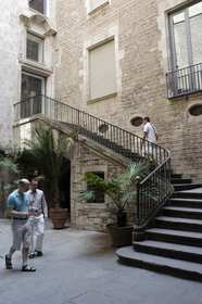
- The Picasso museum is "the" museum to visit in Barcelona. For the artist and for the building. Located in Montcada street, in the Gothic area, five medieval palaces linked together to make a museum. Concerning Pablo Ruiz Picasso the museum is indispensable for understanding his formative years. The genius of the young artist is revealed through the more than 3,500 works that make up the permanent collection. It also reveals his relationship with Barcelona: an intimate, solid relationship that was shaped in his adolescence and youth, and continued until his death. To see as well some oils and drawings from Picasso's Barcelona period and even some works from later stages in his career. The Museum also has a set of 42 pieces of ceramics (vases, dishes and plates) made in the 1950s and bequeathed by Jaqueline Picasso in 1982.
- Santa Maria del Mar is a Gothic church from the 14th century, located at the seaside, was built as a private initiative on the wealth accrued from overseas ventures by the inhabitants of La Ribera. The stained glass windows of this basilica, dating from the 15th and 18th centuries, are very famous. From the outside, Santa Maria gives an impression of massive severity that belies the interior. It is hemmed in by the narrow streets of the Ribera, making it difficult to obtain an overall impression, except from the Fossar de les Moreres and the Plaça de Santa Maria, both of them former burial grounds. The latter is dominated by the west end of the church with its rose window. Images of Saint Peter and Saint Paul occupy niches on either side of the west door, and the tympanum shows the Saviour flanked by Our Lady and Saint John. The north-west tower was completed in 1496, but its companion was not finished until 1902.
- The Cathedral of the Holy Cross and Saint Eulalia, also known as Barcelona Cathedral, is the Gothic cathedral and seat of the Archbishop of Barcelona. The cathedral was constructed throughout the 13th to 15th centuries, with the principal work done in the 14th century. The cloister, which encloses the Well of the Geese (Font de les Oques) was completed about 1450. The neo-Gothic façade was constructed over the nondescript exterior that was common to Catalan churches in the 19th century. The roof is notable for its gargoyles, featuring a wide range of animals, both domestic and mythical. The cathedral was constructed over the crypt of a former Visigothic chapel, dedicated to Saint James, which was the proprietary church of the Viscounts of Barcelona, one of whom, Mir Geribert, sold the site to Bishop Guislebert in 1058. Its site faced the Roman forum of Barcelona.
- Casa Milà. After the Sagrada Familia, Casa Milà or "la Pedrera" as it is often called, is probably Gaudi's second most popular building in Barcelona. Casa Milà covers an area of more than 100 square meters and includes two large circular patios, so that almost every part of the house gets its share of sunlight. It is constructed entirely in natural stones, and lacking all the colors and ornamentation design. Maybe one of the most interesting places of the whole complex is the rooftop: here you can find a large ensemble of surrealistic chimneys all looking different and like sculptures standing there alone or in small groups, dominating the rooftop.
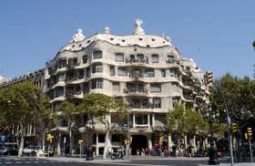
Casa Milà or "la Pedrera" - References: http://www.barcelona.com/

Bari

Bari is the capital city of the province of Bari and of the Puglia region, on the Adriatic Sea, in Italy. It is the second most important economic centre of mainland Southern Italy after Naples, and is well known as a port and university city, as well as the city of Saint Nicholas.
The city was probably founded by the Peucetii. Once it passed under Roman rule in the 3rd century BC, it developed strategic significance as the point of junction between the coast road and the Via Traiana and as a port for eastward trade; a branch road to Tarentum led from Barium. Its harbour, mentioned as early as 181 BC, was probably the principal one of the district in ancient times, as it is at present, and was the centre of a fishery. The first historical Bishop of Bari was Gervasius who was noted at the Council of Sardica in 347. The bishops were dependent on the Patriarch of Constantinople until the 10th century.

After the devastations of the Gothic Wars, under Lombard rule a set of written regulations was established, the Consuetudines Barenses, which influenced similar written constitutions in other southern cities.
Until the arrival of the Normans, Bari continued to be governed by the Byzantines, with only occasional interruption. Throughout this period, and indeed throughout the Middle Ages, Bari served as one of the major slave depots of the Mediterranean, providing a central location for the trade in Slavic slaves. The slaves were mostly captured by Venice from Dalmatia, the Holy Roman Empire from what is now Prussia and Poland, and the Byzantines from elsewhere in the Balkans, and were generally destined for other parts of the Byzantine Empire and (most frequently) the Muslim states surrounding the Mediterranean: the Abbasid Caliphate, the Umayyad Caliphate of Córdoba, the Emirate of Sicily, and the Fatimid Caliphate (which relied on Slavs purchased at the Bari market for its legions of Sakalaba Mamluks).
For 20 years, Bari was the center of the Emirate of Bari; the city was captured by its first emirs Kalfun in 847, who had been part of the mercenary garrison installed there by Radelchis I of Benevento. The city was conquered and the Emirate extinguished in 871, due to the efforts of Emperor Louis II and a Byzantine fleet. Chris Wickham states Louis spent five years campaigning to reduce then occupy Bari, "and then only to a Byzantine/Slav naval blockade"; "Louis took the credit" for the success, adding "at least in Frankish eyes", then concludes by noting that by remaining in southern Italy long after this success, he "achieved the near-impossible: an alliance against him of the Beneventans, Salernitans, Neapolitans and Spoletans; later sources include Sawadān as well."

In 885, Bari became the residence of the local Byzantine catapan, or governor. The failed revolt (1009–1011) of the Lombard nobles Melus of Bari and his brother-in-law Dattus, against the Byzantine governorate, though it was firmly repressed at the Battle of Cannae (1018), offered their Norman adventurer allies a first foothold in the region. In 1025, under the Archbishop Byzantius, Bari became attached to the see of Rome and was granted "provincial" status.
In 1071, Bari was captured by Robert Guiscard, following a three-year siege. Maio of Bari (died 1160), a Lombard merchant's son, was the third of the great admirals of Norman Sicily. The Basilica di San Nicola was founded in 1087 to receive the relics of this saint, which were surreptitiously brought from Myra in Lycia, in Byzantine territory. The saint began his development from Saint Nicholas of Myra into Saint Nicholas of Bari and began to attract pilgrims, whose encouragement and care became central to the economy of Bari. In 1095 Peter the Hermit preached the first crusade there. In October 1098, Urban II, who had consecrated the Basilica in 1089, convened the Council of Bari, one of a series of synods convoked with the intention of reconciling the Greeks and Latins on the question of the filioque clause in the Creed, which Anselm ably defended, seated at the pope's side. The Greeks were not brought over to the Latin way of thinking, and the Great Schism was inevitable.

A civil war broke out in Bari in 1117 with the murder of the archbishop, Riso. Control of Bari was seized by Grimoald Alferanites, a native Lombard, and he was elected lord in opposition to the Normans. By 1123, he had increased ties with Byzantium and Venice and taken the title gratia Dei et beati Nikolai barensis princeps. Grimoald increased the cult of St Nicholas in his city. He later did homage to Roger II of Sicily, but rebelled and was defeated in 1132.
Bari was occupied by Manuel I Komnenos between 1155–1158. In 1246, Bari was sacked and razed to the ground; Frederick II, Holy Roman Emperor and King of Sicily, repaired the fortress of Baris but it was subsequently destroyed several times. Bari recovered each time.
Bari was occupied by Manuel I Komnenos between 1155–1158. In 1246, Bari was sacked and razed to the ground; Frederick II, Holy Roman Emperor and King of Sicily, repaired the fortress of Baris but it was subsequently destroyed several times. Bari recovered each time.
Isabella di Aragona, princess of Naples and widow of the Duke of Milan Gian Galeazzo Sforza, enlarged the castle, which she made her residence, 1499–1524. After the death of Bona Sforza, Queen of Poland, Bari came to be included in the Kingdom of Naples and its history contracted to a local one, as malaria became endemic in the region. Bari was awakened from its provincial somnolence by Napoleon's brother-in-law Joachim Murat. As Napoleonic King of Naples, Murat ordered the building in 1808 of a new section of the city, laid out on a rational grid plan, which bears his name today as the Murattiano. Under this stimulus, Bari developed into the most important port city of the region. The legacy of Mussolini can be seen in the imposing architecture along the seafront.

Through a tragic coincidence intended by neither of the opposing sides in World War II, Bari gained the unwelcome distinction of being the only European city to experience chemical warfare in the course of that war.
On the night of December 2, 1943, German Junkers Ju 88 bombers attacked the port of Bari, which was a key supply centre for Allied forces fighting their way up the Italian Peninsula. Several Allied ships were sunk in the overcrowded harbour, including the U.S. Liberty ship John Harvey, which was carrying mustard gas; mustard gas was also reported to have been stacked on the quayside awaiting transport. The chemical agent was intended for use if German forces initiated chemical warfare. The presence of the gas was highly classified, and authorities ashore had no knowledge of it. This increased the number of fatalities, since physicians—who had no idea that they were dealing with the effects of mustard gas—prescribed treatment proper for those suffering from exposure and immersion, which proved fatal in many cases. Because rescuers were unaware they were dealing with gas casualties, many additional casualties were caused among the rescuers through contact with the contaminated skin and clothing of those more directly exposed to the gas.
.jpg)
On the orders of allied leaders Franklin D. Roosevelt, Winston Churchill and Dwight D. Eisenhower, records were destroyed and the whole affair was kept secret for many years after the war. The U.S. records of the attack were declassified in 1959, but the episode remained obscure until 1967. Indeed, even today, many "Baresi" are still unaware of what happened and why. Additionally, there is considerable dispute as to the number of fatalities. In one account: "[S]ixty-nine deaths were attributed in whole or in part to the mustard gas, most of them American merchant seamen;" Others put the count as high as, "more than one thousand Allied servicemen and more than one thousand Italian civilians." Part of the confusion and controversy derives from the fact that the German attack, which became nicknamed "The Little Pearl Harbor" after the Japanese air attack on the American naval base in Hawaii, was highly destructive and lethal in itself, apart from the effects of the gas. Attribution of the causes of death to the gas, as distinct from the direct effects of the German attack, has proved far from easy.
The affair is the subject of two books: Disaster at Bari, by Glenn B. Infield, and Nightmare in Bari: The World War II Liberty Ship Poison Gas Disaster and Coverup, by Gerald Reminick.
The affair is the subject of two books: Disaster at Bari, by Glenn B. Infield, and Nightmare in Bari: The World War II Liberty Ship Poison Gas Disaster and Coverup, by Gerald Reminick.

Bari's cuisine, one of Italy's most traditional and noteworthy, is based on three typical agricultural products found within the surrounding Puglia region, namely wheat, olive oil and wine. Bari cuisine is also enriched by the wide variety of fruit and vegetables produced locally.
Local flour is used in homemade bread and pasta production including, most notably, the famous orecchiette ear-shaped pasta, recchietelle or strascinate, chiancarelle (orecchiette of different sizes) and cavatelli.
Homemade dough is also used for baked calzoni stuffed with onions, anchovies, capers and olives; fried panzerotti with mozzarella, simple focaccia alla barese with tomatoes, little savoury taralli, friselle and sgagliozze, fried slices of polenta all make up the Bari culinary reportoire.
Olive oil and garlic are widely in use. Vegetable minestrone, chick peas, broad beans, chickory, celery and fennel are also often served as first courses or side dishes.
Meat dishes and the local Barese ragù often include lamb, pork and often horse meat, considered something of a local delicacy.
Pasta al forno, a baked pasta dish, is very popular in Bari and was historically a Sunday dish, or a dish used at the start of Lent when all the rich ingredients such as eggs and pork had to be used for religious reasons. The recipe commonly consists of penne or similar tubular pasta shapes, a tomato sauce, small beef and pork meatballs and halved hard boiled eggs; but different families have variations. The pasta is then topped with mozzarella or similar cheese and then baked in the oven to make the dish have its trademark crispy texture.
Bari, being the capital of an important fishing area, offers a range of fresh fish and seafood, often eaten raw. Octopus, sea urchins and mussels feature heavily. Indeed, perhaps Bari's most famous dish is the oven-baked Riso, patate e cozze (rice, with potatoes and mussels).
Bari and its province, not to mention the Puglia region, have a range of notable wines including Primitivo, Castel del Monte and Moscato di Trani.
Bari and its province, not to mention the Puglia region, have a range of notable wines including Primitivo, Castel del Monte and Moscato di Trani.

Bari’s Top 5:
- Bari Cathedral is the cathedral of Bari, senior to, though less famous than, the Basilica of St. Nicholas. The cathedral is the seat of the Archbishop of Bari-Bitonto, as it was previously of the archbishops, earlier bishops, of Bari. It is dedicated to Saint Sabinus, a bishop of Canosa, whose relics were brought here in the 9th century. The present building was constructed between the late 12th and late 13th centuries, mostly in the last thirty years of the 12th century, and was built on the site of the ruins of the Imperial Byzantine cathedral destroyed in 1156 by William I of Sicily known as the Wicked (il Malo); to the right of the transept it is still possible to observe traces of the original pavement which extends under the nave.
- The Castello Svevo (Swabian Castle) Probably built in 1132 by Norman King Roger II, it was destroyed in 1156 by king William I of Sicily and rebuilt and reinforced in 1233 by the Holy Roman emperor Fredrick II. During the Angevin domination, it went through several transformation, and after being acquired by Duke Ferdinand of Aragon, was donated to the Sforza family and passed to Bona Sforza, Queen of Poland. After Bona's death, it was returned under the King of Naples and transformed into a prison and barracks. The castle is surrounded by a moat on all sides, except the northern section, which was bordering the sea and can be accessed from the bridge and the gate on the southern side. It is mainly composed of the Aragon walls and the main Swabian tower, and is currently used for exhibitions.
- The Teatro Petruzzelli is the largest theatre of the city of Bari and the fourth Italian theatre by size. The history of the Teatro Petruzzelli of Bari begins when Onofrio and Antonio Petruzzelli, traders and ship builders of Trieste presented the design of the theatre of their brother-in-law, the engineer Angelo Bari Cicciomessere (then Messeni) at the city of Bari. The proposal of the Petruzzellis was accepted and in 1896 they signed the contract between the family and the city administration. The contract is dated 29 January 1896. Two years later, in October 1898, work began and ended in 1903. Inside the theatre was painted by Raffaele Armenise. Petruzzelli took from the Corato the primacy of the largest theatre of Puglia. The theatre was inaugurated on Saturday 14 February 1903 with the masterpiece of Meyerbeer, Les Huguenots.
- The Pinacoteca Provinciale di Bari or The Provincial Pinacotheca in Bari is an important Italian Artistic Paintings Museum. It was instituted on July 12, 1928 and initially accommodated at the Palace of Government. In 1936 it moved to the Palace of Province, along the sea boulevard in Bari, where nowadays is still kept its huge artistic inheritance. The Pinacoteca was named in honour of the famous Italian painter Corrado Giaquinto.
- The Basilica di San Nicola is a church in Bari, that holds wide religious significance throughout Europe and the Christian world. The basilica is an important pilgrimage destination both for Roman Catholics and Orthodox Christians from Eastern Europe.
The basilica was built between 1087 and 1197, during the Italo-Norman domination of Apulia, the area previously occupied by the Byzantine Catapan of which Bari was the seat. Its foundation is related to the stealing of some of the relics of St. Nicholas from the saint’s original shrine in Myra, in what is now Turkey. The new church was built to shelter Nicholas' remains and Pope Urban II was present at the consecration of the crypt in 1089.


Basel

Basel or Basle is Switzerland's third most populous city with about 166,000 inhabitants. Located where the Swiss, French and German borders meet, Basel also has suburbs in France and Germany.
During the days of the Roman Empire, the settlement of Augusta Raurica was founded 10 or 20 kilometres upstream of present Basel, and a castle was built on the hill overlooking the river where the Basel Münster now stands. But even older Celtic settlements (including a vitrified fort) have been discovered recently in the area predating the Roman castle.
The town of Basel was called Basilea or Basilia in Latin (from Ancient Greek Basileia, Βασιλεια meaning kingship) and this name is documented from 374 AD.

The Magyars destroyed Basel in 917, and later burnt down the monasteries of St. Gallen and Rheinau. Their incursions only ended when they were routed by the German king Otto I in 955.
In 1019 the construction of the cathedral of Basel (known locally as the Münster) began under German Emperor Heinrich II. In 1225–1226 the Bridge over the Rhine was constructed by Bishop Heinrich von Thun and lesser Basel (Kleinbasel) founded as a bridgehead to protect the bridge. The bridge was largely funded by Basel's Jewish community which had settled there a century earlier. For many centuries to come Basel possessed the only permanent bridge over the river "between Lake Constance and the sea".
The Bishop also allowed the furriers to found a guild in 1226. Eventually about 15 guilds were established in the 13th century. They increased the town's, and hence the bishop's, reputation, influence, and income from the taxes and duties on goods in Basel's expanding market.
In 1347 the plague came to Europe but did not reach Basel until June 1349. The guilds, asserting that the Jews were responsible—several had been tortured and confessed—demanded they be executed, which the Council did in January 1349, except for a few who escaped to Alsace. The council then forbade Jews in Basel for 200 years, except that their money was helpful in rebuilding after the Basel earthquake of 1356 which destroyed much of the city along with a number of castles in the vicinity. The city offered courts to nobles as an alternative to rebuilding their castles, in exchange for the nobles' military protection of the city.

In 1412 (or earlier) the well-known guesthouse Zum Goldenen Sternen was established. Basel became the focal point of western Christendom during the 15th century Council of Basel (1431–1449), including the 1439 election of antipope Felix V. In 1459 Pope Pius II endowed the University of Basel where such notables as Erasmus of Rotterdam and Paracelsus later taught. At the same time the new craft of printing was introduced to Basel by apprentices of Johann Gutenberg.
The Schwabe publishing house was founded in 1488 by Johannes Petri and is the oldest publishing house still in business. Johann Froben also operated his printing house in Basel and was notable for publishing works by Erasmus. In 1495, Basel was incorporated in the Upper Rhenish Imperial Circle; the Bishop of Basel was added to the Bench of the Ecclesiastical Princes. In 1500 the construction of the Basel Münster was finished. In 1521 so was the bishop. The Council, under the supremacy of the guilds, explained that henceforth they would only give allegiance to the Swiss Confederation, to whom the bishop appealed but in vain.


In 1792 the Republic of Rauracia, a revolutionary French client republic, was created. It lasted until 1793. After three years of political agitation and a short civil war in 1833 the disadvantaged countryside seceded from the Canton of Basel, forming the half canton of Basel-Landschaft.
Basel's "shopping mile" goes from Clarastrasse (Claraplatz) to Marktplatz and up Freiestrasse and Gerbergasse to Heuwaage and Bankverein. Much of the shopping here is in specialty stores and luxury boutiques, with a few department stores. Like other large Swiss cities, Basel has many jewelers, horologers (watches), and chocolatiers. Try to veer off the beaten track and check out Schneidergasse (off of Marktplatz), the hilly Spalenberg and adjacent little alleyways such as Heuberg, Nadelberg, which are not only lovely to walk through but where you are likely to find more original shops, selling artisan jewelry, antiques, specialty items, vintage clothing, books, art, etc. Retailers are generally cheery and very competent, polite and helpful.

Prices of name brands are generally uniform across the city - and across the country. Discounting has only recently made inroads in Basel. Expect to pay the same price anywhere for a Swiss Army knife or a watch.
Most stores close promptly at 6:30PM Mo-Fr, except for Thursday when many stores are open until 8 or 9PM. Stores close by 5PM on Saturday and nothing is open on Sunday. Exceptions are the stores in and around the train station, the supermarket Coop Pronto at Barfüsserplatz and a number of small family businesses in residential areas. VAT is included in prices, and there is generally no haggling. Some luxury stores offer tax-free shopping for tourists.

The Schwabe publishing house was founded in 1488 by Johannes Petri and is the oldest publishing house still in business. Johann Froben also operated his printing house in Basel and was notable for publishing works by Erasmus. In 1495, Basel was incorporated in the Upper Rhenish Imperial Circle; the Bishop of Basel was added to the Bench of the Ecclesiastical Princes. In 1500 the construction of the Basel Münster was finished. In 1521 so was the bishop. The Council, under the supremacy of the guilds, explained that henceforth they would only give allegiance to the Swiss Confederation, to whom the bishop appealed but in vain.
The city had remained neutral through the Swabian War of 1499 despite being plundered by soldiers on both sides. The Treaty of Basel ended the war and granted the Swiss confederates exemptions from the emperor Maximillian's taxes and jurisdictions, separating Switzerland de facto from the Holy Roman Empire.

On 9 June 1501 Basel joined the Swiss Confederation as its eleventh canton. It was the only canton that had been asked to join, not the other way round. Basel, had a strategic location, good relations with Strasbourg and Mulhouse, and control of the corn imports from Alsace, whereas the Swiss lands were becoming overpopulated and had few resources. For its part, Basel secured the military help of the other cantons when threatened, and some protection for its rural subjects outside its walls. A provision of the Charter accepting Basel required that in conflicts among the other cantons it was to stay neutral and offer its services for mediation.
In 1503 the new bishop Christoph von Utenheim refused to give Basel a new constitution whereupon, to show its power, the city began the construction of a new city hall.
In 1529 the city became Protestant under Oecolampadius and the bishop's seat was moved to Porrentury. The bishop's crook was however retained as the city's coat of arms.
The first edition of Christianae religionis institutio (Institutes of the Christian Religion – John Calvin's great exposition of Calvinist doctrine) was published at Basel in March 1536.
In 1544, Johann von Brugge a rich Dutch Protestant refugee was given citizenship and lived respectfully until his death in 1556 then buried with honors. His body was exhumed and burnt at the stake in 1559 after it was discovered that he was the Anabaptist David Joris.

In 1543 De humani corporis fabrica, the first book on human anatomy, was published and printed in Basel by Andreas Vesalius (1514–1564).
There are indications Joachim Meyer, author of the influential 16th century martial arts text Kunst des Fechten ("The Art of Fencing") came from Basel. In 1662 the Amerbaschsches Kabinett was established in Basel as the first public museum of art. Its collection became the core of the later Basel Museum of Art.
There are indications Joachim Meyer, author of the influential 16th century martial arts text Kunst des Fechten ("The Art of Fencing") came from Basel. In 1662 the Amerbaschsches Kabinett was established in Basel as the first public museum of art. Its collection became the core of the later Basel Museum of Art.
In 1792 the Republic of Rauracia, a revolutionary French client republic, was created. It lasted until 1793. After three years of political agitation and a short civil war in 1833 the disadvantaged countryside seceded from the Canton of Basel, forming the half canton of Basel-Landschaft.
Basel's "shopping mile" goes from Clarastrasse (Claraplatz) to Marktplatz and up Freiestrasse and Gerbergasse to Heuwaage and Bankverein. Much of the shopping here is in specialty stores and luxury boutiques, with a few department stores. Like other large Swiss cities, Basel has many jewelers, horologers (watches), and chocolatiers. Try to veer off the beaten track and check out Schneidergasse (off of Marktplatz), the hilly Spalenberg and adjacent little alleyways such as Heuberg, Nadelberg, which are not only lovely to walk through but where you are likely to find more original shops, selling artisan jewelry, antiques, specialty items, vintage clothing, books, art, etc. Retailers are generally cheery and very competent, polite and helpful.

There are many places in Basel, including bigger kiosks, where you can buy (relatively) cheap - and mostly kitschy - souvenirs, but if you're looking for something special, go to Heimatwerk (see below). Souvenirs are also available at the SBB Station.
Prices of name brands are generally uniform across the city - and across the country. Discounting has only recently made inroads in Basel. Expect to pay the same price anywhere for a Swiss Army knife or a watch.
Most stores close promptly at 6:30PM Mo-Fr, except for Thursday when many stores are open until 8 or 9PM. Stores close by 5PM on Saturday and nothing is open on Sunday. Exceptions are the stores in and around the train station, the supermarket Coop Pronto at Barfüsserplatz and a number of small family businesses in residential areas. VAT is included in prices, and there is generally no haggling. Some luxury stores offer tax-free shopping for tourists.

Basel’s Top 5:
- The Basel Minster is one of the main landmarks and tourist attractions of the Swiss city of Basel. It adds definition to the cityscape with its red sandstone architecture and coloured roof tiles, its two slim towers and the cross-shaped intersection of the main roof. The Münster is listed as a heritage site of national significance. Originally a Catholic cathedral and today a reformed Protestant church, it was built between 1019 and 1500 in Romanesque and Gothic styles. The late Romanesque building was destroyed by the 1356 Basel earthquake and rebuilt by Johannes Gmünd, who was at the same time employed for building the Freiburg Münster. This building was extended from 1421 by Ulrich von Ensingen, architect of the cathedral towers at Ulm and Strasbourg. The southern tower was completed in 1500 by Hans von Nußdorf.
- The Basel Town Hall locally known as Roothuus is a five hundred years old building dominating the Marktplatz in Basel. The Town Hall houses the meetings of the Cantonal Parliament as well as the Cantonal Government of the canton of Basel-Stadt. The Great Council Chamber at one time featured a series of frescoes painted in 1522 by Hans Holbein the Younger however these have mostly been lost. Fragments of the work as well as some of the initial drawings are kept in the Kunstmuseum.
- The Basel Historical Museum, opened in 1894, is one of the largest and most important museums of its kind in Switzerland, and a heritage site of national significance. The museum is divided into four sections (buildings), three of which are within the city of Basel. These are Barfüsserkirche, Haus zum Kirschgarten and the Musikmuseum. The fourth section, the Coach and Carriage Museum lies slightly outside Basel, in the neighbouring town of Münchenstein.
- The Gates to the Walled City. A (third) ring of fortifications around the whole old city was constructed after the great earthquake of 1356, to provide security for the then roughly 20,000 inhabitants of Basel. A number of these gates can still be seen at the perimeter of what used to be the medieval city
- Zoo Basel is, with over 1.7 million visitors per year, the most visited tourist attraction in Basel and the second most visited tourist attraction in Switzerland. Established in 1874, Zoo Basel is the oldest zoo in Switzerland and, by number of animals, the largest. Through its history, Zoo Basel has had several breeding successes, such as the first worldwide Indian rhinoceros birth and Greater flamingo hatch in a zoo. These and other achievements led Forbes Travel to rank Zoo Basel as one of the fifteen best zoos in the world in 2008. Despite its international fame, Basel's population remains attached to Zoo Basel, which is entirely surrounded by the city of Basel. Evidence of this is the millions of donations money each year, as well as Zoo Basel's unofficial name: locals lovingly call "their" zoo "Zolli" by which is it known throughout Basel and most of Switzerland.


Bath

Bath is a city in the ceremonial county of Somerset in South West England. It is situated 97 miles (156 km) west of London and 13 miles (21 km) south-east of Bristol. It was granted city status by Royal Charter by Queen Elizabeth I in 1590, and was made a county borough in 1889 which gave it administrative independence from its county, Somerset. The city became part of Avon when that county was created in 1974. Since 1996, when Avon was abolished, Bath has been the principal centre of the unitary authority of Bath and North East Somerset (B&NES).
The hills around Bath such as Bathampton Down saw human activity from the Mesolithic period. Several Bronze Age round barrows were opened by John Skinner in the 18th century. Bathampton Camp may have been an Iron Age hill fort or stock enclosure. A Long barrow site believed to be from the Beaker people was flattened to make way for RAF Charmy Down.

Archaeological evidence shows that the site of the Roman Baths' main spring was treated as a shrine by the Iron Age Britons, and was dedicated to the goddess Sulis, whom the Romans identified with Minerva; however, the name Sulis continued to be used after the Roman invasion, leading to the town's Roman name of Aquae Sulis (literally, "the waters of Sulis"). Messages to her scratched onto metal, known as curse tablets, have been recovered from the Sacred Spring by archaeologists. These curse tablets were written in Latin, and usually laid curses on people by whom the writers felt they had been wronged. For example, if a citizen had his clothes stolen at the baths, he would write a curse, naming the suspects, on a tablet to be read by the Goddess Sulis Minerva.
The temple was constructed in 60–70 AD and the bathing complex was gradually built up over the next 300 years. During the Roman occupation of Britain, and possibly on the instructions of Emperor Claudius, engineers drove oak piles into the mud to provide a stable foundation and surrounded the spring with an irregular stone chamber lined with lead. In the 2nd century, the spring was enclosed within a wooden barrel-vaulted building, which housed the calidarium (hot bath), tepidarium (warm bath), and frigidarium (cold bath). The city was given defensive walls, probably in the 3rd century. After the failure of Roman authority in the first decade of the 5th century, the baths fell into disrepair and were eventually lost due to silting up.
The temple was constructed in 60–70 AD and the bathing complex was gradually built up over the next 300 years. During the Roman occupation of Britain, and possibly on the instructions of Emperor Claudius, engineers drove oak piles into the mud to provide a stable foundation and surrounded the spring with an irregular stone chamber lined with lead. In the 2nd century, the spring was enclosed within a wooden barrel-vaulted building, which housed the calidarium (hot bath), tepidarium (warm bath), and frigidarium (cold bath). The city was given defensive walls, probably in the 3rd century. After the failure of Roman authority in the first decade of the 5th century, the baths fell into disrepair and were eventually lost due to silting up.
Bath may have been the site of the Battle of Mons Badonicus (c. 500 AD), where King Arthur is said to have defeated the Anglo-Saxons, although this is disputed. The city fell to the West Saxons in 577 after the Battle of Deorham the Anglo-Saxon poem known as The Ruin may describe the appearance of the Roman site about this time. A monastery was set up in Bath at an early date – reputedly by Saint David, though more probably in 675 by Osric, King of the Hwicce, perhaps using the walled area as its precinct. Nennius, a ninth-century historian, mentions a "Hot Lake" in the land of the Hwicce, which was along the Severn, and adds "It is surrounded by a wall, made of brick and stone, and men may go there to bathe at any time, and every man can have the kind of bath he likes. If he wants, it will be a cold bath; and if he wants a hot bath, it will be hot". Bede also describes hot baths in the geographical introduction to the Ecclesiastical History in terms very similar to those of Nennius. King Offa of Mercia gained control of this monastery in 781 and rebuilt the church, which was dedicated to St. Peter.

By the 9th century the old Roman street pattern had been lost and Bath had become a royal possession, with King Alfred laying out the town afresh, leaving its south-eastern quadrant as the abbey precinct. In the Burghal Hidage Bath is described as having walls of 1,375 yards (1,257 m) and was allocated 1000 men for defence. During the reign of Edward the Elder coins were minted in the town, based on a design from the Winchester mint but with 'BAD' on the obverse relating to the Anglo-Saxons name for the town Baðum, Baðan or Baðon, meaning "at the baths," and this was the source of the present name. Edgar of England was crowned king of England in Bath Abbey in 973.
King William Rufus granted the city to a royal physician, John of Tours, who became Bishop of Wells and Abbot of Bath, following the sacking of the town during the Rebellion of 1088. It was papal policy for bishops to move to more urban seats, and he translated his own from Wells to Bath. He planned and began a much larger church as his cathedral, to which was attached a priory, with the bishop's palace beside it. New baths were built around the three springs. However, later bishops returned the episcopal seat to Wells, while retaining the name of Bath in their title as the Bishop of Bath and Wells.

By the 15th century, Bath's abbey church was badly dilapidated and in need of repairs. Oliver King, Bishop of Bath and Wells, decided in 1500 to rebuild it on a smaller scale. The new church was completed just a few years before Bath Priory was dissolved in 1539 by Henry VIII. The abbey church was allowed to become derelict before being restored as the city's parish church in the Elizabethan era, when the city experienced a revival as a spa. The baths were improved and the city began to attract the aristocracy. Bath was granted city status by Royal charter by Queen Elizabeth I in 1590.
During the English Civil War, the city was garrisoned for King Charles the 1st and seven thousand pounds spent on fortifications. However upon the appearance of parliamantary forces the gates were thrown open and the city surrendered, and it then become a significant post in Somerset for the New Model Army under William Waller. It was retaken by royalists following the Battle of Lansdowne which was fought on 5 July 1643 on the northern outskirts of the city. Thomas Guidott, who had been a student of chemistry and medicine at Wadham College, Oxford, moved to Bath and set up practice in 1668. He became interested in the curative properties of the waters and he wrote A discourse of Bathe, and the hot waters there. Also, Some Enquiries into the Nature of the water in 1676. This brought the health-giving properties of the hot mineral waters to the attention of the country and soon the aristocracy started to arrive to partake in them.
During the English Civil War, the city was garrisoned for King Charles the 1st and seven thousand pounds spent on fortifications. However upon the appearance of parliamantary forces the gates were thrown open and the city surrendered, and it then become a significant post in Somerset for the New Model Army under William Waller. It was retaken by royalists following the Battle of Lansdowne which was fought on 5 July 1643 on the northern outskirts of the city. Thomas Guidott, who had been a student of chemistry and medicine at Wadham College, Oxford, moved to Bath and set up practice in 1668. He became interested in the curative properties of the waters and he wrote A discourse of Bathe, and the hot waters there. Also, Some Enquiries into the Nature of the water in 1676. This brought the health-giving properties of the hot mineral waters to the attention of the country and soon the aristocracy started to arrive to partake in them.

Several areas of the city underwent development during the Stuart period, and this increased during Georgian times in response to the increasing number of visitors to the spa and resort town who required accommodation. The architects John Wood the elder and his son John Wood the younger laid out the new quarters in streets and squares, the identical façades of which gave an impression of palatial scale and classical decorum. Much of the creamy gold Bath Stone used for construction throughout the city was obtained from the limestone Combe Down and Bathampton Down Mines, which were owned by Ralph Allen (1694–1764).
The population of the city had reached 40,020 by the time of the 1801 census, making it one of the largest cities in Britain.
Emperor Haile Selassie I of Ethiopia spent the four years of his exile, from 1936 to 1940, at Fairfield House in Bath. During World War II, between the evening of 25 April and the early morning of 27 April 1942, Bath suffered three air raids in reprisal for RAF raids on the German cities of Lübeck and Rostock, part of the Luftwaffe campaign popularly known as the Baedeker Blitz. Over 400 people were killed, and more than 19,000 buildings were damaged or destroyed. Houses in the Royal Crescent, Circus and Paragon were burnt out along with the Assembly Rooms, while part of the south side of Queen Square was destroyed.
In 1987 the city was selected by UNESCO as a World Heritage Site, recognising its international cultural significance. In March 2012 a hoard of 30,000 silver Roman coins, one of the largest hoards discovered in Britain, was discovered in Bath during an archaeological dig. The coins, believed to date from the third century, were unearthed about 450 feet from the Roman Baths.

Bath is linked to a variety of foods that are distinctive in their association with the city. The Sally Lunn buns (a type of teacake) have long been baked in Bath. They were first mentioned by that name in verses printed in a local newspaper, the Bath Chronicle, in 1772. At that time they were eaten hot at public breakfasts in the city's Spring Gardens. They can be eaten with sweet or savoury toppings. These are sometimes confused with Bath buns which are smaller, round, very sweet, very rich buns that were associated with the city following The Great Exhibition. Bath buns were originally topped with crushed comfits created by dipping caraway seeds repeatedly in boiling sugar; but today seeds are added to a 'London Bath Bun' (a reference to the bun's promotion and sale at the Great Exhibition).The seeds may be replaced by crushed sugar granules or 'nibs'.
Bath has also lent its name to one other distinctive recipe – Bath Olivers – the dry baked biscuit invented by Dr William Oliver, physician to the Mineral Water Hospital in 1740.Oliver was an early anti-obesity campaigner and the author of a "Practical Essay on the Use and Abuse of warm Bathing in Gluty Cases". In more recent years, Oliver's efforts have been traduced by the introduction of a version of the biscuit with a plain chocolate coating. The Bath Chap, which is the salted and smoked cheek and jawbones of the pig, takes its name from the city. It is still available from a stall in the daily covered market. Also there is a brewery named Bath Ales, located a few miles away in Warmley, Abbey Ales are brewed in the city.

Bath’s Top 5:
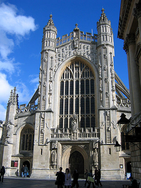
- The Abbey Church of Saint Peter and Saint Paul commonly known as Bath Abbey, is an Anglican parish church and a former Benedictine monastery. Founded in the 7th century, Bath Abbey was reorganised in the 10th century and rebuilt in the 12th and 16th centuries; major restoration work was carried out by Sir George Gilbert Scott in the 1860s. It is one of the largest examples of Perpendicular Gothic architecture in the West Country. The church is cruciform in plan, and is able to seat 1200. An active place of worship, with hundreds of congregation members and hundreds of thousands of visitors each year, it is used for religious services, secular civic ceremonies, concerts and lectures. The choir performs in the abbey and elsewhere. There is a heritage museum in the vaults. The abbey is a Grade I listed building, particularly noted for its fan vaulting. It contains war memorials for the local population and monuments to several notable people, in the form of wall and floor plaques and commemorative stained glass. The church has two organs and a peal of ten bells. The west front includes sculptures of angels climbing to heaven on two stone ladders.
- The Royal Crescent is a street of 30 terraced houses laid out in a sweeping crescent. Designed by the architect John Wood the Younger and built between 1767 and 1774, it is among the greatest examples of Georgian architecture to be found in the United Kingdom and is a Grade I listed building. Although some changes have been made to the various interiors over the years, the Georgian stone façade remains much as it was when it was first built. Many notable people have either lived or stayed in the Royal Crescent since it was first built over 250 years ago, and some are commemorated on special plaques attached to the relevant buildings.
- Pulteney Bridge is a bridge that crosses the River Avon, in Bath. It was completed in 1773 and is designated by English Heritage as a grade I listed building. The bridge was designed by Robert Adam, whose working drawings are preserved in the Sir John Soane's Museum, and is one of only four bridges in the world with shops across the full span on both sides. Shops on the bridge include a flower shop, antique map shop, and juice bar.It is named after Frances Pulteney, heiress in 1767 of the Bathwick estate across the river from Bath. Bathwick was a simple village in a rural setting, but Frances's husband William could see its potential. He made plans to create a new town, which would become a suburb to the historic city of Bath. First he needed a better river crossing than the existing ferry, hence the bridge.
- The Victoria Art Gallery is free public art museum. The building was designed in 1897 by John McKean Brydon, and has been designated as a Grade II listed building. The exterior of the building includes a statue of Queen Victoria, by A. C. Lucchesi, and friezes of classical figures by G. A. Lawson. The Gallery was named to celebrate Queen Victoria's sixty years on the throne. It is run by Bath and North East Somerset council and houses their collection of paintings, sculpture and decorative arts. It includes over 1,500 decorative arts treasures including a display of British oil paintings from 17th century to the present day including works by Thomas Gainsborough, Thomas Jones Barker and Walter Sickert.
- The Roman Baths complex The house is a well-preserved Roman site for public bathing. The Roman Baths themselves are below the modern street level. There are four main features: the Sacred Spring, the Roman Temple, the Roman Bath House and the Museum holding finds from Roman Bath. The buildings above street level date from the 19th century. The Baths are a major tourist attraction and, together with the Grand Pump Room, receive more than one million visitors a year. It was featured on the 2005 TV program Seven Natural Wonders as one of the wonders of the West Country. Visitors can see the Baths and Museum but cannot enter the water. An audio guide is available in several languages.


Belfast

Belfast is the capital of and largest city in Northern Ireland. By population, it is the 14th biggest city in the United Kingdom and 2nd largest on the island of Ireland. It is the seat of the devolved government and legislative Northern Ireland Assembly. Belfast was granted city status in 1888.
The site of Belfast has been occupied since the Bronze Age. The Giant's Ring, a 5,000-year-old henge, is located near the city, and the remains of Iron Age hill forts can still be seen in the surrounding hills. Belfast remained a small settlement of little importance during the Middle Ages. John de Courcy built a castle on what is now Castle Street in the city centre in the 12th century, but this was on a lesser scale and not as strategically important as Carrickfergus Castle to the north, which was built by de Courcy in 1177. The O'Neill clan had a presence in the area. In the 14th century, Cloinne Aodha Buidhe, descendants of Aodh Buidhe O'Neill built Grey Castle at Castlereagh, now in the east of the city.
 |
| City Hall |
Historically, Belfast has been a centre for the Irish linen industry (earning the nickname "Linenopolis"), tobacco production, rope-making and shipbuilding: the city's main shipbuilders, Harland and Wolff, which built the well-known RMS Titanic, propelled Belfast on to the global stage in the early 20th century as the biggest and most productive shipyard in the world.
Today, Belfast remains a centre for industry, as well as the arts, higher education and business, a legal centre, and is the economic engine of Northern Ireland. The city suffered greatly during the period of conflict called The Troubles, but latterly has undergone a sustained period of calm, free from the intense political violence of former years, and substantial economic and commercial growth. Belfast city centre has undergone considerable expansion and regeneration in recent years, notably around Victoria Square. Belfast is also a major seaport, with commercial and industrial docks dominating the Belfast Lough shoreline, including the famous Harland and Wolff shipyard.
 |
| Evidence of the political troubles can still be seen |
Local museums and places of interest including The Titanic’s Dock and Pumphouse and the Ulster Folk Transport Museum offer an insight into the history, industrial heritage and times gone by; while award winning attractions including Belfast Zoo and W5 Interactive Science Centre provide great family days out.
All the great shopping centres of Belfast are within easy walking distance of each other. From the prestigious Victoria Square Shopping Centre development, numerous high street stores, family businesses, luxurious designer boutiques and speciality shops, Belfast has an astonishing array of tempting treasures. Whether its high street or budget shopping, designer or couture, the city offers a wealth of choice for every taste and pocket.

In the tight area around City Hall there is an enclave of wonderful shopping which compares with any found in other cosmopolitan cities. Here you will find specialist retailers and long established family businesses offering dedicated personal service along side many British high street favourites. Designer boutiques, selling the latest international collections, sit beside unique local design houses selling much sought after pieces of clothing, jewellery and shoes. The area to the front of City Hall, stretching from Donegall Place to Royal Avenue, has a score of high street stores including Castlecourt Shopping Centre, housing the popular department store Debenhams. Close to Cornmarket Square you will find Victoria Square, with over 70 stores. Just a year old it's already a favourite shopping venue in the city with an exciting mix of well know names such as The House of Fraser and Build-a-Bear together with exclusive boutiques, restaurants, cinemas and ‘shops for boys’ all housed under a spectacular glass dome that penetrates the night time skyline.

Opening in late March 2012, Titanic Belfast® will be a "must see" visit in any tour of Belfast and Northern Ireland. It is located in the heart of Belfast, on the slipways where RMS Titanic was built. Inside this iconic building, visitors will re-live the entire Titanic story from her birth in Belfast to the fateful maiden voyage and her eventual discovery on the seabed. Immerse yourself in the amazing story of Belfast in the 1900s, take a spin in the Shipyard Ride, experience life on board and learn about Titanic’s maiden voyage, her tragic sinking, the many stories of human endeavour, and the technology and science that finally found her, and helped to solve some of the many mysteries surrounding that fateful night in 1912. For full details follow the link http://www.titanicbelfast.com/Home.aspx
******************************************************

Opening in late March 2012, Titanic Belfast® will be a "must see" visit in any tour of Belfast and Northern Ireland. It is located in the heart of Belfast, on the slipways where RMS Titanic was built. Inside this iconic building, visitors will re-live the entire Titanic story from her birth in Belfast to the fateful maiden voyage and her eventual discovery on the seabed. Immerse yourself in the amazing story of Belfast in the 1900s, take a spin in the Shipyard Ride, experience life on board and learn about Titanic’s maiden voyage, her tragic sinking, the many stories of human endeavour, and the technology and science that finally found her, and helped to solve some of the many mysteries surrounding that fateful night in 1912. For full details follow the link http://www.titanicbelfast.com/Home.aspx
Belfast’s Top 5:
- Belfast Castle. set on the slopes of Cavehill Country Park, in a prominent position 400 feet (120 m) above sea level. Its location provides unobstructed views of the city of Belfast and Belfast Lough. The original Belfast Castle, built in the late 12th century by the Normans, was located in the town itself, flanked by the modern day High Street, Castle Place and Donegall Place in what is now Belfast city centre. This was the home of Sir Arthur Chichester, baron of Belfast, but was burned down in 1708, leaving only street names to mark the site. Rather than rebuild on the original site, the Chichesters decided to build a new residence in the city's suburbs, today's Belfast Castle emerging as a result. The building that stands today was built from 1811–70 by the 3rd Marquess of Donegall. After Donegall's death and the family's financial demise, the 8th Earl of Shaftesbury completed the house. It was his son, the 9th Earl of Shaftesbury, who presented the castle to the City of Belfast in 1934. In 1978, Belfast City Council began a major refurbishment over a period of ten years at a cost of over two million pounds. The building officially re-opened to the public on 11 November 1988.The castle boasts an antiques shop, a restaurant and visitors centre and it is a popular venue for conferences, private dining and wedding receptions.
- The Albert Memorial Clock is a tall clock tower situated at Queen's Square. It was completed in 1869 and is one of the best known landmarks of Belfast.
History. In 1865 a competition for the design of a memorial to Queen Victoria's late Prince Consort, Prince Albert, was won by W. J. Barre, who had earlier designed Belfast's Ulster Hall. The sandstone memorial was constructed between 1865 and 1869 and stands 113 feet tall in a mix of French and Italian Gothic styles. A two tonne bell is housed in the tower. As a result of being built on wooden piles on marshy, reclaimed land around the River Farset, the top of the tower leans four feet off the perpendicular. Due to this movement, some ornamental work on the belfry was removed in 1924 along with a stone canopy over the statue of the Prince. Being situated close to the docks, the tower was once infamous for being frequented by prostitutes plying their trade with visiting sailors. However, in recent years regeneration has turned the surrounding Queen's Square and Custom's House Square into attractive, modern public spaces with trees, fountains and sculptures. - St Anne's Cathedral. also known as Belfast Cathedral, is a cathedral of the Church of Ireland in Donegall Street. It is unusual in serving two separate dioceses (Connor and Down and Dromore), yet being the seat of neither, (it is geographically in the Diocese of Connor,) it is therefore not a cathedral in the truest sense of the word, a cathedral being a church housing the seat of a bishop, it is however titled as such. It is the focal point of the Cathedral Quarter. The first architect was Sir Thomas Drew, the foundation stone being laid on September 6, 1899 by the Countess of Shaftesbury. The old parish church of St Anne had continued in use, up until 31 December 1903, while the new cathedral was constructed around it; the old church was then demolished. The Good Samaritan window, to be seen in the Cathedral Sanctuary, is the only feature of the old church to be retained in the Cathedral. Initially, only the nave of the Cathedral was built, and this was consecrated on 2 June 1904.
- Belfast City Hall. is the civic building of the Belfast City Council. Located in Donegall Square, it faces north and effectively divides the commercial and business areas of the city centre. The site now occupied by Belfast City Hall was once the home of the White Linen Hall, an important international Linen Exchange. The Street that runs from the back door of Belfast City Hall through the middle of Linen Quarter is Linen Hall Street.
Plans for the City Hall began in 1888 when Belfast was awarded city status by Queen Victoria. During this period Belfast briefly overtook Dublin as the most populous city on the island of Ireland. Construction began in 1898 under the supervision of architect Sir Alfred Brumwell Thomas and was completed in 1906 at a cost of £369,000. Belfast Corporation (now the council) used their profits from the gas industry to pay for the construction. - Stormont. The Parliament Buildings, known as Stormont because of its location in the Stormont area of Belfast is the seat of the Northern Ireland Assembly and the Northern Ireland Executive. It previously housed the old Parliament of Northern Ireland. The need for a separate parliament building for Northern Ireland emerged with the creation of the Northern Ireland home rule region in the Government of Ireland Act 1920. In 1922, preparatory work on the chosen site, east of Belfast, began. The original plans for a large domed building with two subsidiary side buildings, housing all three branches of government - legislative, executive and judicial - gave rise to the plural in the official title still used today. Alongside the parliament and "Ministerial Building" the site would have been host to the Northern Ireland High Court. The plans were scrapped following the Stock Market Crash of 1929 and its knock-on effect on the economy of the United Kingdom. Instead, a smaller domeless building designed by Sir Arnold Thornley in the Greek classical style and fronted in Portland stone, was erected on the site. It was built by Stewart & Partners and opened by Edward, Prince of Wales (later King Edward VIII) on 16 November 1932. William Stewart who ran the building firm which built Stormont, Stewart and Partners, was the brother of a son-in-law of Frederick James Crozier founder of the Hermitage Golf Club in Dublin.

 |
| Albert Memorial |
 |
| Stormont |
Belgrade

Belgrade is the capital and largest city of Serbia. The city is located at the confluence of the Sava and Danube rivers, where the Pannonian Plain meets the Balkans. Its name in English translates to White city. The city proper has a population of over 1.1 million, while its metropolitan area has over 1.6 million people, making it one of the largest cities in Southeast Europe.
One of the largest prehistoric cultures of Europe, the Vinča culture, evolved around the area Belgrade in the 6th millennium BC. In antiquity, Thraco-Dacians inhabited the region, and after 279 BC Celts conquered the city, naming it Singidūn. It was conquered by the Romans during the reign of Augustus, and awarded city rights in the mid 2nd century. It was settled by the Slavs in the 520s, and changed hands several times before it became the capital of King Stephen Dragutin (1282–1316). In 1521 Belgrade was conquered by the Ottoman Empire and became the seat of a the Sanjak of Smederevo. It frequently passed from Ottoman to Habsburg rule, which saw the destruction of most of the city during the Austro-Ottoman wars. Belgrade was again named the capital of Serbia in 1841. The north of Belgrade remained a Habsburg outpost until 1918, when it was merged into the capital city. As a strategic location, the city was battled over in 115 wars and razed to the ground 44 times. Belgrade was the capital of Yugoslavia (in various forms of governments) from its creation in 1918, to its final dissolution in 2006.
 |
| Cathedral of St Sava |
In the inner area of the City of Belgrade there are over 5,500 streets, 16 plazas and 32 squares. The oldest streets that have retained their original routes are: Vase Čarapića, Kralja Petra, Cara Dušana, Jevrejska, Narodnog fronta, Gavrila Principa, and Karađorđeva Streets. The development of the street network started in 1867, after the Turks had departed, when the regulatory plan of Belgrade was adopted, which had been drawn up by engineer Emilijan Josimović. In the territories of the 10 City municipalities, the oldest is the Student Square, and the most famous one is the Republic Square.

Kneza Mihaila Street is a pedestrian zone and shopping center - protected by law as one of the oldest and most valuable monumental complexes of the city, with a large number of representative buildings and urban houses built at the end of 1870s. It is thought that in as early as the Roman times there was the center of the Singidunum settlement. In this area, at the time of Turks, there were winding streets with gardens, drinking-fountains and mosques. In the mid19th century, in the upper part of the street was the garden of Knez Aleksandar Karađorđević. After the making of the regulation plan of Belgrade in 1867, byEmilijan Josimović, the street has soon been built and gained its physionomy and content. The houses have been built there and the most influential and wealthiest families of the commercial and political society of Belgrade have come to live there. In 1870, the city authorities officially gave a name to this street - Ulica Kneza Mihaila.
Belgrade has a reputation for offering a vibrant nightlife, and many clubs that are open until dawn can be found throughout the city. The most recognizable nightlife features of Belgrade are the barges (splavovi) spread along the banks of the Sava and Danube Rivers.
Many weekend visitors—particularly from Bosnia-Herzegovina, Croatia and Slovenia—prefer Belgrade nightlife to that of their own capitals, due to a perceived friendly atmosphere, great clubs and bars, cheap drinks, the lack of language difficulties, and the lack of restrictive night life regulation. The Times reported that Europe's best nightlife can be found in buzzing Belgrade. In the Lonely Planet "1000 Ultimate Experiences" guide of 2009, Belgrade was placed in the number 1 spot of the top 10 party cities in the world.
Belgrade’s Top 5:
- Belgrade Fortress. High above the Sava and Danube confluence, on the rocky ridge which overlooks The city, Zemun and wide plains of Pannonia, there is the Belgrade Fortress with Kalemegdan, the former historical and urban center of Belgrade. This spatial complex consists of: The Fortress, divided into Upper Town and Lower Town, and the Kalemegdan park, the most popular promenade for Belgrade citizens. Because of its exceptional strategic significance, at the end of the first century A.D. the Romans built a fortress here - Roman castrum, as a permanent military camp of the IV Flavius' legion. After its destruction by the Goths and Huns, it was reconstructed in the first decades of the sixth century. Less than a hundred years later, it was destroyed by the Avars and Slavs. A mediaeval town has developed over the centuries in the Fortress area, clinging on to safety within its thick walls. The Belgrade Fortress has been destroyed and renewed many times. Above the Roman walls there are the Serbian walls, and above these the Turkish and Austrian fortifications. In the twelfth century, the Byzantine Czar Manuel Comnenus erected a new castle upon the Roman ruins. In the first decades of the fourteenth century, this small stronghold on the hill was expanded to the river banks.
- The Cathedral of Saint Sava or Saint Sava Temple in the Vračar region of Belgrade, is an Orthodox church, the largest in the Balkans, and one of the 10 largest church buildings in the world. The church is dedicated to Saint Sava, founder of the Serbian Orthodox Church and an important figure in medieval Serbia. It is built on the Vračar plateau, on the location where his remains were burned in 1595 by the Ottoman Empire's Sinan Pasha. From its location, it dominates Belgrade's cityscape, and is perhaps the most monumental building in the city. The building of the church structure is being financed exclusively by donations. The parish home is nearby, as will be the planned patriarchal building. It is not a cathedral in the technical ecclesiastical sense, as it is not the seat of a bishop (the seat of the Metropolitan bishop of Belgrade is St. Michael's Cathedral). In Serbian it is called a hram (temple), which is in Eastern Orthodoxy another name for a church. In English, it is usually called a cathedral because of its size and importance.
- The National Museum. The largest and oldest museum in Serbia. It is located in Republic Square. The museum was established on May 10, 1844. Since it was founded, its collections have to over 400,000 objects including many foreign masterpieces. The National Museum building was declared a Monument of Culture of Great Importance in 1979. The Museum has 34 archeological, numismatic, artistic and historical collections today. The main collection consists of sculptures from Vinca (6–5th millennium B.C.) such as Lady of Vinča and Lepenski Vir (7th millennium B.C.). There are also numerous sculptures, weapons, helmets and other items from ancient Rome and 1005 items from ancient Greece and items from Ancient Celtic people. The most valuable pieces from that period are Dupljaja Chariot (16-13th century B.C), golden masks from Trebenište (6th century B.C.), household sets from Jabučje (1st century A.D.), the Belgrade Cameo (4th century) .Silver belt with swastika, 5th century BC. There is also a collection from ancient Egypt. The most famous piece is a rare gold sarcophagus and mummy of the Egyptian priest Nesmin.
- The Old Palace. The palace was built between 1882 and 1884, according to the design of Aleksandar Bugarski, in the style of academism of the 19th century, with intention to surpass all existing residences of the Serbian rulers. A number of important events from the time of the political power of the Obrenović dynasty are linked to the Old Palace: the Palace was built when Serbia was proclaimed a Kingdom; in that same building, King Milan abdicated in favor of his son, Aleksandar, on February 22, 1889. Between 1903 and 1914, the Old Palace was the residence of the Karadjordjević dynasty. In 1919 and 1920, meetings of the Provisional National Assembly took place there. Royal festivities and receptions of foreign guests took place there until 1941.
- Skadarlija. is a vintage street, an urban neighborhood and former municipality of Belgrade. It is located in the Belgrade municipality of Stari Grad (Old town) and generally considered the main bohemian quarter of Belgrade, styled as the Belgrade Montmartre. Skadarlija is located less than 300 metres (330 yd) north-west of Terazije, central Belgrade. It begins right below the Republic Square and stretches along the short, winding Skadarska Street. One of the most famous streets in Belgrade, it is less than 400 metres (440 yd) long. It connects the Despot Stefan Boulevard with the Dušanova Street, near the Bajloni open green market and the Mira Trailović Square, where it extends into the neighborhood of Dorćol. Skadarlija became a separate municipality of Belgrade in 1952, after the previous post-World War II division of Belgrade into raions from 1945 to 1952 ended. That municipality included a large portion of urban Belgrade, mainly the Danube oriented neighborhoods like Dorćol, Jalija, Stari Grad, etc. On January 1, 1957 it merged into the new municipality of Stari Grad.

The bohemian area. Skadarlija


Berlin

Berlin is the capital city of Germany and is one of the 16 states of Germany. With a population of 3.49 million people, Berlin is Germany's largest city and is the second most populous city proper and the seventh most populous urban area in the European Union. Located in northeastern Germany, it is the center of the Berlin-Brandenburg Metropolitan Region, which has 4.4 million residents from over 190 nations. Located in the European Plains, Berlin is influenced by a temperate seasonal climate. Around one third of the city's area is composed of forests, parks, gardens, rivers and lakes.
First documented in the 13th century, Berlin was the capital of the Kingdom of Prussia (1701–1918), the German Empire (1871–1918), the Weimar Republic (1919–1933) and the Third Reich (1933–1945). Berlin in the 1920s was the third largest municipality in the world. After World War II, the city became divided into East Berlin—the capital of East Germany—and West Berlin, a West German exclave surrounded by the Berlin Wall(1961–1989). Following German reunification in 1990, the city regained its status as the capital of Germany, hosting 147 foreign embassies. Berlin's history has left the city with a highly eclectic array of architecture and buildings. The city's appearance today is predominantly shaped by the key role it played in Germany's history in the 20th century. Each of the national governments based in Berlin initiated ambitious re-construction programmes, with each adding its own distinctive style to the city's architecture. Berlin was devastated by bombing raids during World War II, and many of the buildings that had remained after the war were demolished in the 1950s and 1960s in both West and East Berlin. Much of this demolition was initiated by municipal architecture programs to build new residential or business quarters and main roads.
.jpg) |
| Berlin Cathedral |
Many of the well known buildings, examples of East Berlin’s attempt to compete with the Western side’s own in-your-face high-rises were erected during this time. The Hotel Stadt Berlin – a 123m high Hotel, the Haus des Lehrers (Teachers’ House); a venue for pedagogues which remained more of a representative façade than a real educational forum; The House of Travel with a slightly amusing ring to it given the notorious travel restrictions during the GDR and the publishing house building - today’s Berliner Verlag – offices of the Berlin daily, Berliner Zeitung.
In the 1970s, under Erich Honecker, Alexanderplatz became an experiment in socialist urban aesthetics. The honeycomb aluminium façade of the former “Centrum Warenhaus”, (Kaufhof Group today) was the largest department store in the GDR and is today a transformed department store designed by Josef Paul Kleihues.
Amongst the sights to look out for here are the 365 metre TV tower, Berlin´s highest construction topped by a globe (turned into a pink football during the 2006 World Cup Event) with a rotating viewing platform. The Brunnen der Völkerfreundschaft (Fountain of Friendship amongst Peoples) and the landmark World Time Clock erected in 1969 served as a popular meeting place. Berolina House by Peter Behrens is now a C&A branch and the Alexa shopping mall includes a multiplex cinema.
 |
| Alexanderplatz TV Tower |
Berlin's nightlife is one of the most diverse and vibrant of its kind in Europe. Throughout the 1990s, people in their twenties from many countries, particularly those in Eastern and Central Europe, made Berlin's club scene the premier nightlife destination of Europe. After the fall of the Berlin Wall in 1989, many historic buildings in Mitte, the former city center of East Berlin, were illegally occupied and re-built by young squatters and became a fertile ground for underground and counterculture gatherings. Berlin is notable for the length of its parties as clubs are not required to close at a fixed time on the weekends, and many parties last well into the morning, or all weekend. Berghain features the Panorama Bar, so named because the bar opens its shades at daybreak, allowing party-goers a panorama view of Berlin after dancing through the night.
Berlin’s Top 5:
- The Brandenburg Gate. One of Berlin’s most important monuments – a landmark and symbol all in one with over two hundred years of history. A former symbol of the divided city, it drew visitors who used to climb an observation platform in order to get a glimpse of the world behind the Iron Curtain, on the other side of the barren “death-strip” which separated east from west Berlin, geographically and politically. It was here that on June 12, 1987, Ronald Regan issued his stern command to his cold war adversary admonishing him with the words: “Mr. Gorbachov – tear down this wall!”. The speech delivered to West Berliners was also audible on the east side of the Gate and echoed President von Weizsacker’s words which translate as: “The German question is open as long as the Brandenburg Gate is closed.” When Germany was reunified following the fall of the Berlin Wall in November 1989 the Brandenburg Gate quickly reinvented itself into the New Berlin’s symbol of unity. It was officially opened to traffic on December 22, 1989 and 100,000 people came to celebrate the occasion. Unfortunately this also resulted in severe damage to the monument which needed to be restored and was only officially reopened on October 3, 2002.
- The Berliner Dom (Berlin Cathedral). Completed in 1905, is Berlin’s largest and most important Protestant church as well as the sepulchre of the Prussian Hohenzollern dynasty. This outstanding high-renaissance baroque monument has linked the Hohenzollerns to German Protestantism for centuries and undergone renewed phases of architectural renovation since the Middle Ages. First built in 1465 as a parish church on the Spree River it was only finally completed in 1905 under the last German Kaiser -Wilhelm II. Damaged during the Second World War it remained closed during the GDR years and reopened after restoration in 1993. The “old” Cathedral at the Lustgarten was initially constructed between 1747 and 1750 under Friedrich the Great (1740-1786) as a baroque church in accordance with Knobersdorff’s plans by Johann Bourmann. From 1817 to 1822 Karl Friedrich Schinkel redesigned it but the Cathedral retained its stylistic similarity to the high-renaissance baroque architecture of St. Peter’s Cathedral in Rome. Finally, official plans reconciling the different stages and stylistic developments were presented by Julius Rashdorff in 1885 to King Friedrich Wilhelm IV. When Wilhelm II ascended the throne in 1888 he authorised the demolition of the “old” Cathedral and the construction, began in 1893, of the much larger, imposing present Berliner Dom.
- Checkpoint Charlie. Along with Glienicker Brücke (Glienicker Bridge) was the best known border-crossing of Cold War days. The sign, which became a symbol of the division of Cold War Berlin and read like a dire warning to those about to venture beyond the Wall – YOU ARE NOW LEAVING THE AMERICAN SECTOR – in English, Russian, French and German - stood here. It is today an iconic marker of territorial boundary and political division. Until the fall of the Berlin Wall on November 9, 1989, it signified the border between West and East, Capitalism and Communism, freedom and confinement.
The spot remains a must see sight in Berlin with huge historical and emotional resonance, even accounting for the fact that there is remarkably little left to recall the atmosphere of pre-1989 days. An enormous amount of debating went into deciding what should be left here and preserved for Berliners and visitors to see in the future. - Alexanderplatz. ‘Alex’ to Berliners, a cattle market in the Middle Ages, a military parade square and an exercise ground for nearby barracks until the mid 19th century - Alexanderplatz is the square named to honour Alexander I, Tsar of Russia, on his visit to Berlin in 1805. It was here that Alfred Döblin took the pulse of the cosmopolitan metropolis portrayed in his 1929 novel ‘Berlin Alexanderplatz’ filmed by Fassbinder for a TV series as a portrait of the bustling city in the 1920s before the imminent Nazi takeover. Fast forward to more recent times, one million people congregated here, on 4 November 1989 to demonstrate against the GDR regime shortly before the fall of the Berlin Wall. This was the largest anti-government demonstration in its history. Layer upon layer of Berlin’s urban history is located in Alexanderplatz, interweaving centuries of social, political, and architectural history and repeatedly the subject of public debate and urban design competitions. The transformation of Alexanderplatz into a modern transit junction and shopping area came about during the second half of the 19th century with developments such as the construction of the S-Bahn, Berlin’s surface rail network in 1882 and the underground railway from 1913. Devasted during the war the square gradually developed into the pedestrian zone during the 1960s becoming a popular if rather amorphous urban area.
- The Reichstag Building. Constructed to house the Reichstag, parliament of the German Empire. It was opened in 1894 and housed the Reichstag until 1933, when it was severely damaged in a fire. After the Second World War the Reichstag building fell into disuse as the parliament of the German Democratic Republic met in the Palace of the Republic in East Berlin and the parliament of the Federal Republic of Germany met in the Bundeshaus in Bonn. The building was made safe against the elements and partially refurbished in the 1960s, but no attempt at full restoration was made until after the reunification of Germany on October 3, 1990, when it underwent reconstruction led by internationally renowned architect Norman Foster. After its completion in 1999, it became the meeting place of the modern German parliament, the Bundestag. In today's usage, the German term Reichstag or Reichstagsgebäude (Reichstag building) refers to the building, while the term Bundestag refers to the institution.

The Reichstag Building


References: http://www.berlin.de
Bergen

Bergen is a city and municipality in Hordaland on the west coast of Norway. As of 13 February 2013, the municipality had a population of 268,100 and Greater Bergen had a population of 394,300, making Bergen the second-largest city in Norway. The municipality covers an area of 465 square kilometers (180 sq mi) and is located on the peninsula of Bergenshalvøyen. The city center and northern neighborhoods are located on Byfjorden and the city is surrounded by mountains, traditionally held to be seven mountains. Many of the extra-municipal suburbs are located on islands.
The city of Bergen was traditionally thought to have been founded by king Olav Kyrre, son of Harald Hardråde in 1070 AD, four years after the Viking Age ended. Modern research has, however, discovered that a trading settlement was established already during the 1020s or 1030s. Bergen gradually assumed the function of capital of Norway in the early 13th century, as the first city where a rudimentary central administration was established. The city's cathedral was the site of the first royal coronation in Norway in the 1150s, and continued to host royal coronations throughout the 13th century. The functions of capital city were lost to Oslo during the reign of King Haakon V (1299–1319). In the middle of the 14th century, North German merchants who had already been present in substantial numbers since the 13th century, founded one of the four kontors of the Hanseatic League at Bryggen in Bergen.

The principal export traded from Bergen was dried cod from the northern Norwegian coast, which started around 1100. By the late 14th century, Bergen had established itself as the centre of the trade in Norway. The Hanseatic merchants lived in their own separate quarter of town, where Middle Low German was used, enjoying exclusive rights to trade with the northern fishermen that each summer sailed to Bergen. Today, Bergen's old quayside, Bryggen is on UNESCO's list of World Heritage Site.
The city's history is marked by numerous great fires. In 1198, the Bagler-faction set fire to the city in connection with a battle against the Birkebeiner faction during the civil war. In 1248, Holmen and Sverresborg burned, and 11 churches were destroyed. In 1413 another fire struck the city, and 14 churches were destroyed. In 1428 the city was plundered by German pirates, and in 1455, Hanseatic merchants were responsible for burning down Munkeliv Abbey. In 1476, Bryggen burned down in a fire started by a drunk trader. In 1582, another fire hit the city centre and Strandsiden. In 1675, 105 buildings burned down in Øvregaten. In 1686 a new great fire hit Strandsiden, destroying 231 city blocks and 218 boathouses. The greatest fire to date happened in 1702 when 90 percent of the city was burned to ashes. In 1751, there was a great fire at Vågsbunnen. In 1756, a new fire at Strandsiden burned down 1,500 buildings, and further great fires hit Strandsiden in 1771 and 1901. In 1916, 300 buildings burned down in the city centre, and in 1955 parts of Bryggen burned down.
In 1349, the Black Death was inadvertently brought to Norway by the crew of an English ship arriving in Bergen. In the 15th century, the city was several times attacked by the Victual Brothers, and in 1429 they succeeded in burning the royal castle and much of the city. In 1665, the city's harbour was the site of the Battle of Vågen, where an English naval flotilla attacked a Dutch merchant and treasure fleet supported by the city's garrison.

Throughout the 15th and 16th centuries, Bergen remained one of the largest cities in Scandinavia, and was Norway's biggest city until the 1830s, when the capital city of Oslo became the largest. From around 1600, the Hanseatic dominance of the city's trade gradually declined in favour of Norwegian merchants (often of Hanseatic ancestry), and in the 1750s, the Hanseatic Kontor finally closed. Bergen retained its monopoly of trade with Northern Norway until 1789.
During World War II, Bergen was occupied on the first day of the German invasion on 9 April 1940, after a brief fight between German ships and the Norwegian coastal artillery. On 20 April 1944, during the German occupation, the Dutch cargo ship Voorbode anchored off the Bergenhus Fortress, loaded with over 120 tons of explosives, blew up, killing at least 150 people and damaging historic buildings. The city was subject to some Allied bombing raids, aiming at German naval installations in the harbour. Some of these caused Norwegian civilian casualties numbering about 100.
Bergen was separated from Hordaland as a county of its own in 1831. It was established as a municipality on 1 January 1838. The rural municipality of Bergen landdistrikt was merged with Bergen on 1 January 1877. The rural municipality of Årstad was merged with Bergen on 1 July 1915. The rural municipalities of Arna, Fana, Laksevåg, and Åsane were merged with Bergen on 1 January 1972. The city lost its status as a separate county on the same date. Bergen is now a municipality in Norway, in the county of Hordaland.

There is a great variety of restaurants and cafes in Bergen, but you should expect to spend some time looking for the best places. In the most central parts of the city, many of the restaurants are all the same. Move a block away from the most central parts of downtown to find lower prices and better food. Kitchens usually close at 11PM at the latest.
Waiters and other restaurant staff have good wages. You are not required to leave any money to cover the service, but many people choose to tip the waiter if he or she has been helpful and nice, and if the food was good. If you choose to leave a tip, rounding up or adding about five to ten percent will be appreciated. A rule of thumb would be that the more expensive the food is, the more are you expected to leave a tip.
Keep in mind that tap water is safe to drink and (usually) free of charge. To save money, ask for tap water to drink.
Finding local food might take some effort, but there are some options. There aren't that many local dishes available at restaurants. "Norwegian" food is the food of the husmann (cottager) – nutritious and cheap, not what you usually find in a restaurant. The Bergen fish soup might be the most important, as well as raspeballer and cooked cod. If you want to get that Norwegian taste and have a gourmet meal at the same time, look for dishes that use "local" ingredients (such as reindeer, stockfish and cod) with a twist, such as Bryggen Tracteursted's filet of reindeer farced with goat cheese.

Many cafe's and restaurants serve "raspeballer" on Thursdays. Raspeballer are local potato dumplings, in Bergen usually served with bacon, sausages, salted meat from sheep, melted butter and mashed rutabaga.
In November, December and January, traditional Christmas food is served in many restaurants. Look for "pinnekjøtt" (cured, dried and sometimes smoked meat of lamb or mutton), "lutefisk" (lit. "lye fish", dried cod prepared with lye) and "ribbe" (oven-baked pork ribs). For a very special experience, try smalahove (sheep's head). It is a traditional dish from Voss not far from Bergen.
Night clubs are usually open from 11pm, but life never starts before 1am. Bars opens at different hours, some can be open all day. No places are allowed to serve alcohol after 2:30am, and the consumption of alcoholic beverages must cease at 3am at the latest. Some places are required to close earlier. The establishments are only allowed to let people bring their drinks outside if they have been granted a special permit. A requirement to get this permit is that they have a confined space outdoors for their guests. All drinks must be indoors by 1am.

People go out all week, but Fridays and Saturdays are the best nights, Saturdays being the clear winner (most places will be a bit too crowded on Saturdays). Some clubs have a 2 for 1 policy on Wednesdays, and Sunday is usually the night for people in the industry.
Most places require that you are 20 years of age and that you can provide a valid ID, even if you are much older. Valid IDs are Norwegian bank cards, European standard driver's licenses and ID cards and passports.
Remember that smoking in all indoor areas where people work is strictly prohibited by law in Norway. Most restaurants, bars, night clubs etc. will require you to leave if you try to smoke indoors.
Drinking in public is illegal. Emptying a can in front of a police officer on a Saturday night will earn you a kr. 2500 fine. If you stroll through a park a bit outside the city center on a sunny day you will still see a lot of people having a beer or a glass of wine with the picnic. The police usually won't mind as long as everything passes in an orderly fashion.

Bergen’s Top 5:
- Bergen Cathedral is the seat of the Diocese of Bjørgvin in the Church of Norway, the first recorded reference to it is dated 1181. It retains its ancient dedication to St Olaf. During the reign of king Haakon IV of Norway, a Franciscan friary was established near the church, then known as Olavskirken, or the church of Saint Olaf, which was incorporated in it. The church burned down in 1248 and again in 1270, but was reconstructed after both fires. In 1463, it burned down again, but this time it was not reconstructed until the 1550s, despite being declared the cathedral in 1537. After the fires of 1623 and 1640, Bergen Cathedral received its current general appearance. The steeple on the nave was torn down, and the current tower was built. During the renovation in the 1880s by architect Christian Christie, the Rococo interior was replaced to give the interiors back their former medieval appearance. A cannonball from the 1665 Battle of Vågen between the English and Dutch fleets remains embedded in the cathedral's exterior wall.
- St. John's Church is located on Sydneshaugen in the neighbourhood of Sydnes in Bergen. St John's was built between 1891 and 1894 in the Gothic Revival style. With 1250 seats, it is the largest church in Bergen. In 1888, an architectural contest was conducted for the design of a new church. It was built from drawings by architect, Herman Major Backer (1856–1932). The frescoes in the Church's ceiling date from 1924 and were completed by Hugo Lous Mohr (1889-1970). The building process was first lead by architect Adolf Fischer and from 1891 by Hans Heinrich Jess. The church was consecrated in 1894. The altarpiece depicts Christ in prayer and was designed in 1894 by Marcus Grønvold. The church tower is the highest in the city at 61 metres.
- Bryggens musem After the fire in 1955, when a lot of Bryggen burnt down, remains of the first settlement on Bryggen were discovered. The museum is built over these up to 900 years old wooden building foundations, giving a unique insight in Bryggen's architectural history. It contains the world's largest collection of medieval runic inscriptions, mostly inscribed on wooden items, but only a small number of these are on display. It also hosts themed exhibitions.
- Gamlehaugen The villa at Gamlehaugen, built to resemble a castle, was the home of Christian Michelsen, former prime minister who helped free Norway from the Swedish rule through the peaceful dissolution of the "union" in 1905. Nowadays, the villa is the royal family's residence in Bergen. There is a large and very popular park around the villa.
- Bergenhus fortress Once the seat of the king, Bergenhus fortress is one of the oldest and best preserved forts of Norway. The oldest surviving buildings are from the mid 13th century, but the area was a royal residence from the late 11th century. The fortress is situated close to the international ferry terminal. The royal hall, Håkonshallen, (Haakon's Hall), named for King Haakon Haakonsson, was built some time between 1247 and 1261. It is used today for royal galas, as a banqueting hall for the city council, and other public events.


Bern

The city of Bern or Berne is the Bundesstadt (federal city, de facto capital) of Switzerland, and, the fourth most populous city in Switzerland. The official language of Bern is German, but the main spoken language is the Alemannic dialect called Bernese German. In 1983 the historic old town in the centre of Bern became a UNESCO World Heritage Site and Bern is ranked among the world’s top ten cities for the best quality of life (2010).
No archaeological evidence that indicates a settlement on the site of today′s city centre prior to the 12th century has been found so far. In antiquity, a Celtic oppidum stood on the “Engehalbinsel” north of Bern, fortified since the 2nd century BC (late La Tène period), thought to be one of the twelve oppida of the Helvetii mentioned by Caesar. During the Roman era, there was a Gallo-roman vicus on the same site. The Bern zinc tablet has the name Brenodor "dwelling of Breno". In the Early Middle Ages, there was a settlement in Bümpliz, now a city district of Bern, some 4 km (2 mi) from the medieval city.

The medieval city is a foundation of the Zähringer ruling family, which rose to power in Upper Burgundy in the 12th century. According to 14th century historiography (Cronica de Berno, 1309), Bern was founded in 1191 by Berthold V, Duke of Zähringen. In 1218, after Berthold died without an heir, Bern was made a free imperial city by the Goldene Handfeste of Holy Roman Emperor Frederick II.
In 1353 Bern joined the Swiss Confederacy, becoming one of the "eight cantons" of the formative period of 1353 to 1481. Bern invaded and conquered Aargau in 1415 and Vaud in 1536, as well as other smaller territories, thereby becoming the largest city-state north of the Alps, by the 18th century comprising most of what is today the canton of Bern and the canton of Vaud.
The city grew out towards the west of the boundaries of the peninsula formed by the River Aare. Initially, the Zytglogge tower marked the western boundary of the city from 1191 until 1256, when the Käfigturm took over this role until 1345, which, in turn, was then succeeded by the Christoffelturm (located close to today's train station) until 1622. During the time of the Thirty Years' War two new fortifications, the so-called big and small Schanze (entrenchment), were built to protect the whole area of the peninsula.
 |
| Federal Palace |
After a major blaze in 1405, the original wooden buildings were gradually replaced by half-timbered houses and later the sandstone buildings that came to be characteristic for the Old Town. Despite the waves of pestilence that hit Europe in the 14th century, the city continued to grow mainly due to immigration from the surrounding countryside.
Bern was occupied by French troops in 1798 during the French Revolutionary Wars, when it was stripped of parts of its territories. It regained the Bernese Oberland in 1802, and following the Congress of Vienna of 1814 newly acquired the Bernese Jura, once again becoming the largest canton of the confederacy as it stood during the Restoration, and further until the secession of the canton of Jura in 1979. In 1848 Bern was made the Federal City (seat of the Federal Assembly) of the new Swiss federal state.

A number of congresses of the socialist First and Second Internationals were held in Bern, particularly during World War I when Switzerland was neutral.
As with most other cities in Switzerland, store opening and closing hours in Berne are strictly regulated. All stores, including grocers, close by 7PM or 7.30pm from Monday to Friday, except on Thursdays when they remain open until 9.30PM. Aldi supermarkets are an exception, closing at 8PM during the week. On Saturdays everything must close by 5PM. On Sundays, all stores are closed, except for those in the main railway station, which are open 7 days a week until about 10PM, and which include Migros and Coop supermarkets. Rathausgasse and the streets parallel to it have any number of cute shops with an amazing range of handicraft and luxury goods. This is not the normal range of swiss souvenir stuff, but really interesting things.
Eating in Berne (or almost anywhere in Switzerland for that matter) can be an expensive proposition for foreign tourists. Be sure to "shop around" before deciding on a restaurant as many of them cater to foreign tourists (especially those serving traditional Swiss food) and have inflated their prices accordingly. Most Bernese natives prefer Italian, Asian, or other non-local cuisine so finding a traditional Swiss restaurant with acceptable prices can often be a daunting experience. Be patient and you will persevere without breaking the bank.

Bern’s Top 5:
- The Bern Minster (German: Berner Münster) is a Swiss Reformed cathedral, (or minster) in the old city of Bern. Built in the Gothic style, its construction started in 1421. Its tower, with a height of 100.6 m (330 ft), was only completed in 1893. It is the tallest cathedral in Switzerland and is a Cultural Property of National Significance. The Minster of Bern is located on the southern side of the Aare peninsula. The cathedral is oriented east and west like the rest of the Old City of Bern. To the north, Münstergasse runs along the side of the building. The west façade of the Münster dominates Münsterplatz. On the south side of the cathedral is the Münsterplattform. Over the main portal is one of the most complete Late Gothic sculpture collections in Europe. This collection represents the Christian belief in a Last Judgment where the wicked will be separated from the righteous. This sculpture shows the wicked naked on the right, while the righteous stand clothed in white on the left. In the centre is Justice, with Saints and the wise and foolish virgins around her. In the centre stands Michael the Archangel with a raised sword.
- The Federal Palace is the name of the building in Bern in which the Swiss Federal Assembly (federal parliament) and the Federal Council are housed. It consists of a central parliament building and two wings (eastern and western) housing government departments and library. The building was designed by the architect Hans Auer and its inauguration took place on 1 April 1902. The total cost, at the time, was 7,198,000 Swiss Francs.
- The Einsteinhaus (Einstein House) is a museum and a former residence of Albert Einstein. It is located on Kramgasse No. 49. A flat on the second floor of the house was occupied by Albert Einstein, his wife Mileva Marić and their son Hans Albert Einstein from 1903 to 1905. The Annus Mirabilis papers, which contributed substantially to the foundation of modern physics, were written by Einstein in 1905, while he worked at the Federal Institute of Intellectual Property. The living conditions of Einstein and his family are shown accurately in the apartment on the second floor with furniture from that time. Einstein’s biography and his life’s work are presented on the third floor.A larger permanent exhibition is located at the Historical Museum of Bern.
- The Church of the Holy Ghost is a Swiss Reformed Church. The Swiss heritage site of national significance building is located at Spitalgasse 44 in the Old City of Bern. It is one of largest Swiss Reformed churches in Switzerland. The first church was a chapel built for the Holy Ghost hospital and abbey. The chapel, hospital and abbey were first mentioned in 1228 and at the time sat about 150 meters (490 ft) outside the western gate in the first city wall. This building was replaced by the second church between 1482 and 1496. During the 15th century, the Holy Ghost Abbey began to slowly decline. In 1528 the church was secularized by the reformers and the last two monks at the Abbey were driven out of Bern. During the following years it was used as a granary. In 1604 it was again used for religious services, as the hospital church for the Oberer Spital. At that time the church had a maximum capacity of about 750. The second church was demolished in 1726 to make way for a new church building.
- The Zytglogge tower is a landmark medieval tower. Built in the early 13th century, it has served the city as guard tower, prison, clock tower, centre of urban life and civic memorial. Despite the many redecorations and renovations it has undergone in its 800 years of existence, the Zytglogge is one of Bern's most recognisable symbols and, with its 15th-century astronomical clock, a major tourist attraction. It is a heritage site of national significance, and part of the Old City of Bern, a UNESCO World Cultural Heritage site.


References: http://www.bern.com/en/index.cfm
Bilbao

Remains of an ancient settlement were found on the top of mount Malmasín, dated around the 3rd or 2nd century BC. Burial sites were also found on mounts Avril and Artxanda, dated 6,000 years old. Some authors identify the old settlement of Bilbao as Amanun Portus, cited by Pliny the Elder, or with Flaviobriga, by Ptolemy. There are also ancient walls, discovered below the Church of San Antón, dated around the 11th century.

In the fourteenth century, the then lord of Biscay, Diego López V of Haro, founded Bilbao through a municipal charter dated in Valladolid on June 15, 1300 and confirmed by king Ferdinand IV of Castile in Burgos, on January 4, 1301.
Diego López established the new town on the right bank of the Nervión river, on grounds of the elizate of Begoña and granted it the fuero of Logroño, a compilation of rights and privileges that would prove fundamental to its later development.
In 1602 Bilbao was made capital city of Biscay, title previously held by Bermeo. The following centuries saw a constant increase of the city's wealth, especially after the discovery of extensive iron resources in the surrounding mounts. At the end of the 17th century, Bilbao overcame the economical crises that affected Spain thanks to the iron ore and the commerce with England and the Netherlands. During the 18th century the city continued to grow and almost exhausted its small space.
The Basque Country was one of the main scenarios of the Carlist Wars, and the conquer of Bilbao, a liberal and economic bastion was of extreme importance for the Carlists. The city was besieged three times between 1835 and 1874, but all proved unsuccessful. One of the main battles of this time was the Battle of Luchana, when general Baldomero Espartero defetead the Carlists, freeing the city. Despite this, the city could prosper during the nineteenth and twentieth centuries, when it rose as the economical centre of the Basque Country.
 |
| City Hall |
The Spanish Civil War started in Bilbao with small uprisings suppressed by the republican forces. On 31 August 1936, the city suffered the first bombing. On the next month, further bombings of German origin occurred. In May 1937, the Nationalist army besieged the city. The battle lasted until 19 June of that year, when Lieutenant Colonel Putz ordered to destroy all bridges over the estuary and the troops of the 5th Brigade took the city from mounts Malmasin, Pagasarri, and Arnotegi.
With the war over, Bilbao returned to its industrial development, accompanied by a steady population grow. In the 1940s, the city was rebuilt, starting with the bridges. In 1948, the first commercial flight took off from the local airport. Over the next decade, there was a rebirth of the iron industry, which led to the rise of slums in the hillsides. In this chaotic environment, on 31 July 1959, the terrorist organization ETA was born in Bilbao, as a split of PNV(The Basque Nationalist Party).
The first notion of Bilbao as a touristic city came with the inauguration of the railway between Bilbao and the coastal neighbourhood of Las Arenas, in the municipality of Getxo in 1872. This way, the city became a modest beach destination. However, the real touristic impulse would come with the inauguration of the Guggenheim Museum Bilbao in 1997, as shown in the increasing tourist arrivals since then. Most tourists come from within Spain, mainly from Madrid and Catalonia. International travellers come mostly from nearby France, but also from United Kingdom, Germany, and Italy.

If you take a stroll around Bilbao nowadays you will be constantly amazed by the ground-breaking structures designed by some of the most prestigious architects in the world.
As you visit the new spaces created on the banks of the city estuary, you will come upon buildings made of incredible materials: the metal Euskalduna Palace, the Guggenheim Bilbao Museum, whose titanium curves have turned it into the emblem of this increasingly modern destination, and Santiago Calatrava’s Zubizuri Bridge, which as you cross it will remind you of a glass-bottomed sailing boat.
On the streets of the city you will also find the unusual glass-covered entrances to the underground, designed by Norman Foster, and the innovative glass design of the Basque Health Department. The best way of discovering the avant-garde aesthetics of this “city of the future” is to set aside a couple of days and explore the whole of the modern expansion area.Shopping for antiques, typical ceramics, exquisite cakes and pastries or the latest fashions is one of the options offered by the shopping centres and shops of Bilbao. Going shopping in Bilbao is a unique occasion for enjoying the architectural heritage of the city and whilst out you can enjoy the many taverns or cafés lining the streets.
The Old Quarter, Indautxi and Ensanche are the main shopping areas in Bilbao. Here you will find a wide range of products in traditional establishments, shops selling the latest fashions and the modern shopping centres.
 |
| Santiago Cathedral |
Gastronomy is an art in Bilbao. The city is home to prestigious restaurants which offer dishes ranging from traditional cuisine to the most avant-garde culinary creations. Eating well is easy, almost an obligation. You'll find varied menus featuring delicious dishes made with top-quality ingredients. Bilbao is famous for being the capital of cod, because of the wide variety of mouth-watering recipes made with this fish.
We recommend indulging in the local custom known as "chiqueteo" (having pintxos with a drink) in a few of the city's numerous bars before sitting down to have a meal. The counters of these establishments are piled high with the famous pintxos, miniature culinary works of art which will make your mouth water as soon as you lay eyes on them. At the first bite, you’re bound to become a fervent admirer of the Basque custom of “going out for pintxos” –basically, talking a walking tour of several nearby venues to sample the greatest possible number of pintxos. We recommend the areas in the old part of town, Abando and Idautxtu, which are the most popular and always guarantee a great atmosphere.
The tradition of going out for pintxos can be enjoyed all year round, but if you’re lucky enough to be in town in May or June, you can experience the annual pintxo contest, when the best-known bars in Bilbao compete to decide the best pintxo of the year.

Bilbao’s Top 5:
 |
| The Basilica of Begoña |
- Santiago Cathedral is a Catholic Cathedral in the city of Bilbao that was officially declared cathedral in 1950. Its origins probably date to well before the foundation of the city in 1300, when Bilbao was little more than a small enclave of fishermen.
The temple is consecrated in honor of the apostle Saint James the Great (Santiago in Spanish), by virtue of being a point of transit for the pilgrims that followed the Northern branch of the Way of Saint James. Architecturally, the present building is a mixture of styles: from the 15th century Gothic of the cloister and the main vault, where of special interest are the cloister and the beautiful portal that gives access Correo street (Puerta del Angel), to the ostentatious Gothic Revival façade and spire. A curious custom is the addition of stone carvings of local merchants along the buttresses of the main vault. - The Basilica of Begoña (or Basílica de Nuestra Señora de Begoña in Spanish) is a basilica, dedicated to the patron saint of Biscay, the Virgin Begoña. The basilica started life in the 16th century, designed by Sancho Martínez de Arego. It has three naves, to which the addition of vaults was completed in the 17th century in construction work that took a century, having started in 1511. During the time of this work, the Gothic style developed somewhat, with the main entrance being built in the middle of the 16th century in the shape of a magnificent arch as a reminder of the works of Spanish architect Gil de Hontañón. The rest of the building retains the unitarian Gothic style.
- The Zubizuri (Basque for "white bridge"), also called the Campo Volantin Bridge or Puente del Campo Volantin, is a tied arch footbridge across the Nervion River. Designed by architect Santiago Calatrava, the bridge links the Campo Volantin right bank and Uribitarte left bank of the river. Opened in 1997, the bridge's unusual design consists of a curved walkway which is supported by steel suspension cables from an overhead arch. The structure of the bridge is painted white and the bridge deck consists of translucent glass bricks. Access ramps and stairways are located on both banks. The Zubizuri offers pedestrians a convenient route from hotels to the nearby Bilbao Guggenheim Museum. Since its opening, it has been subjected to praise as a symbol of the new Bilbao and as a draw for tourism. The bridge has also been accused of impracticality: it is locally infamous for the glass bricks set into its floor, which can become slippery in the wet climate of the city.
- The City Hall in Bilbao is set on the bank of the river. It was inaugurated in 1892 on the site of the old San Agustín Convent. The building was designed by the architect Joaquín Rucoba, and artists of the period contributed to this elegant, highly ornamental construction. The interior décor features a range of items including furniture, lamps, paintings, windows, sculptures and busts, vases... The Arab Hall is especially outstanding, and was designed by the artist José Soler, who painted the room to imitate marble, wood and ivory.
- The Guggenheim Museum is a museum of modern and contemporary art, designed by Canadian-American architect Frank Gehry, built by Ferrovial. It is built alongside the Nervion River, which runs through the city of Bilbao to the Atlantic Coast. The Guggenheim is one of several museums belonging to the Solomon R. Guggenheim Foundation. The museum features permanent and visiting exhibits of works by Spanish and international artists. One of the most admired works of contemporary architecture, the building has been hailed as a "signal moment in the architectural culture", because it represents "one of those rare moments when critics, academics, and the general public were all completely united about something." The museum was the building most frequently named as one of the most important works completed since 1980 in the 2010 World Architecture Survey among architecture experts.


Bologna

Bologna is the largest city (and the capital) of Emilia-Romagna Region in Northern Italy.
The area around Bologna has been inhabited since the 9th century BC, as evidenced by the archeological digs in the 19th century in nearby Villanova. This period, and up to the 6th century, is in fact generally referred to as villanovian, and had various nuclei of people spread out around this area. In the 7-6th centuries BC, Etruria began to have an influence on this area, and the population went from Umbrian to Etruscan. The town was renamed Felsina.
.jpg)
In the 4th century BC, the city and the surrounding area were conquered by the Boii, a Celtic tribe from Transalpine Gaul. The tribe settled down and mixed so well with the Etruscans, after a brief period of aggression, that they created a civilization that modern historians call Gaul-Etruscan (one of the best examples is the archeological complex of Monte Bibele, in the Apennines near Bologna). The Gauls dominated the area until 196 BC, when they were sacked by the Romans. After the Battle of Telamon, in which the forces of the Boii and their allies were badly beaten, the tribe reluctantly accepted the influence of the Roman Republic, but with the outbreak of the Punic Wars the Celts once more went on a war path. They first helped Hannibal's army cross the Alps then they supplied him with a consistent force of infantry that proved itself decisive in several battles.
With the downfall of the Carthaginians came the end of the Boii as a free people, the Romans destroyed many settlements and villages (Monte Bibele is one of them) and then founded the colonia of Bononia in c.189 BC. The settlers included three thousand Latin families led by the consul Lucius Valerius Flaccus. The Celtic population was ultimately absorbed into the Roman society but the language has survived in some measure in the Bolognese dialect, which linguists say belongs to the Gallo-Italic group of languages and dialects. The building of the Via Aemilia in 187 BC made Bologna an important centre, connected to Arezzo by way of the Via Flaminia minor and to Aquileia through the Via Aemilia Altinate.
.jpg)
In 88 BC, the city became a municipium: it had a rectilinear street plan with six cardi and eight decumani (intersecting streets) which are still discernible today. During the Roman era, its population varied between c. 12,000 to c. 30,000. At its peak, it was the second city of Italy, and one of the most important of all the Empire, with various temples and baths, a theatre, and an arena. Pomponius Mela included Bononia among the five opulentissimae ("richest") cities of Italy. Although fire damaged the city during the reign of Claudius, the Roman Emperor Nero rebuilt it in the 1st century AD.
After the fall of the Empire, this area fell under the power of Odoacre, Theodore the Great (493-526), Byzantium and finally the Longobards, who used it mostly as a military centre. In 774, the city fell to Charlemagne, who gave it to Pope Adrian I.
After the fall of the Empire, this area fell under the power of Odoacre, Theodore the Great (493-526), Byzantium and finally the Longobards, who used it mostly as a military centre. In 774, the city fell to Charlemagne, who gave it to Pope Adrian I.
After a long decline, Bologna was reborn in the 5th century under bishop Petronius. According to legend, St. Petronius built the church of S. Stefano. After the fall of Rome, Bologna was a frontier stronghold of the Exarchate of Ravenna in the Po plain, and was defended by a line of walls which did not enclose most of the ancient ruined Roman city. In 728, the city was captured by the Lombard king Liutprand, becoming part of the Lombard Kingdom. The Germanic conquerors formed a district called "addizione longobarda" near the complex of S. Stefano. Charlemagne stayed in this district in 786.
In the 11th century, Bologna began to aspire to being a free commune, which it was able to do when Matilda of Tuscany died, in 1115, and the following year the city obtained many judicial and economic concessions from Henry V. Bologna joined the Lombard League against Frederick Barbarossa in 1164 which ended with the Peace of Costanza in 1183; after which, the city began to expand rapidly (this is the period in which its famous towers were built) and it became one of the main commercial trade centres thanks to a system of canals that allowed large ships to come and go.
In the 11th century, Bologna began to aspire to being a free commune, which it was able to do when Matilda of Tuscany died, in 1115, and the following year the city obtained many judicial and economic concessions from Henry V. Bologna joined the Lombard League against Frederick Barbarossa in 1164 which ended with the Peace of Costanza in 1183; after which, the city began to expand rapidly (this is the period in which its famous towers were built) and it became one of the main commercial trade centres thanks to a system of canals that allowed large ships to come and go.

In 1337, the rule of the noble Pepoli family, nicknamed by some scholars as the "underground nobles" as they governed as "the first among equals" rather than as true nobles of the city. This noble family's rule was in many ways an extension of past rules, and resisted until March 28, 1401 when the Bentivoglio family took over. The Bentivoglio family ruled Bologna, first with Sante (1445–1462) and then under Giovanni II (1462–1506). This period was a flourishing one for the city, with the presence of notable architects and painters who made Bologna a true city of art. During the Renaissance, Bologna was the only Italian city that allowed women to excel in any profession. Women had much more freedom than in other Italian cities; some even had the opportunity to earn a degree at the university.
Giovanni's reign ended in 1506 when the Papal troops of Julius II besieged Bologna and sacked the artistic treasures of his palace. From that point on, until the 18th century, Bologna was part of the Papal States, ruled by a cardinal legato and by a Senate which every two months elected a gonfaloniere (judge), assisted by eight elder consuls. In 1530, in front of Saint Petronio Church, Charles V was crowned Holy Roman Emperor by Pope Clement VII.
The period of Papal rule saw the construction of many churches and other religious establishments, and the reincarnation of older ones. At this time, Bologna had ninety-six convents, more than any other Italian city. Artists working during this period in Bologna established the Bolognese School which includes Annibale Carracci, Domenichino, Guercino and others of European fame.

In 1796, Napoleon took Bologna with his French troops, and with the rise of Napoleon, Bologna became the capital of the short lived Cispadane Republic. After the fall of Napoleon, and the Congress of Vienna in 1815, Bologna once again fell under the sovereignty of the Papal States, rising up in 1831 and again in 1849, when it temporarily expelled the Austrian garrisons which controlled the city. After a visit by Pope Pius IX in 1857, on 12 June 1859 the city voted in favour of annexation by the Kingdom of Sardinia, soon to become the Kingdom of Italy.
Bologna was bombed heavily during World War II. The strategic importance of the city as industrial and railway hub connecting northern and central Italy made it a strategic target for the Allied forces. On July 16, 1943 a massive aerial bombardment destroyed much of the historic city centre and killed scores of people. The main railway station and adjoining areas were severely hit, and 44% of the buildings in the centre were listed as having been destroyed or severely damaged. The city was heavily bombed again on September 25. The raids, which this time were not confined to the city centre, left 936 people dead and thousands injured.

During the war, the city was also a key centre of the Italian resistance movement. On November 7, 1944, a pitched battle around Porta Lame, waged by partisans of the 7th Brigade of the Gruppi d'Azione Patriottica against Fascist and Nazi occupation forces, did not succeed in triggering a general uprising, despite being one of the largest resistance-led urban conflicts in the European theater. Resistance forces entered Bologna on the morning of April 21, 1945. By this time, the Germans had already largely left the city in the face of the Allied advance, spearheaded by Polish forces advancing from the east during the Battle of Bologna which had been since April 9. First to arrive in the centre was the 87th Infantry Regiment of the Friuli Combat Group under general Arturo Scattini, who entered the centre from Porta Maggiore to the south. Since the soldiers were dressed in British outfits, they were initially thought to be part of the allied forces; when the local inhabitants heard the soldiers were speaking Italian, they poured out on to the streets to celebrate. Polish reconnaissance units of the Polish 2nd Corps entered Bologna from another direction on the same morning as the Friuli Combat Group. The fighting to oust the Germans from the town had been mostly undertaken by Polish troops.
After World War II, Bologna became a thriving industrial centre as well as a political stronghold of the Italian Communist Party, leading the Italian political "Red Quadrilateral".

Bologna is renowned for its culinary tradition. It has given its name to the well-known Bolognese sauce, a meat based pasta sauce called in Italy ragù alla bolognese but in the city itself just ragù as in Tagliatelle al ragù. Situated in the fertile Po River Valley, the rich local cuisine depends heavily on meats and cheeses. As in all of Emilia-Romagna, the production of cured pork meats such as prosciutto, mortadella and salami is an important part of the local food industry. Well-regarded nearby vineyards include Pignoletto dei Colli Bolognesi, Lambrusco di Modena and Sangiovese di Romagna. Tagliatelle with ragù, lasagne, tortellini served in broth, and mortadella, the original Bologna sausage, are among the local specialties. Traditional Bolognese desserts are often linked to holidays, such as fave dei morti, multi-colored almond paste cookies made for All Saints' Day, jam-filled raviole cookies that are served on Saint Joseph's Day, and carnival sweets known as sfrappole. Torta di riso, a custard-like cake made of almonds, rice and amaretto, is made throughout the year.
Bologna’s Top 5:
- Bologna Cathedral dedicated to Saint Peter, is the seat and the metropolitan cathedral of the Archbishop of Bologna. There was already a cathedral on the site (on the present Via Indipendenza) in 1028, accompanied by a pre-Romanesque campanile with a circular base (in the architectural tradition of Ravenna). This church was destroyed by a devastating fire in 1141. It was reconstructed, and consecrated by Pope Lucius III in 1184. In 1396 a high portico (protiro) was added to the west front, which was rebuilt in 1467. In 1582 Pope Gregory XIII elevated the Bishop of Bologna to Archbishop, and accordingly the cathedral was elevated to the rank of "metropolitan church" (a bishop's seat with jurisdiction over other bishops and dioceses in its territory). By order of Cardinal Gabriele Paleotti a radical remodelling of the interior of the building began in 1575, of which the crypt and the Greater Chapel (Capella Maggiore) survive. The alterations were so extensive however as to cause the vaults to collapse in 1599, and the decision was then made to rebuild the main part of the cathedral from scratch. Work on the new building started in 1605. A new façade was added between 1743 and 1747, to designs by the architect Alfonso Torreggiani, on the instructions of Pope Benedict XIV.
- The Towers of Bologna are a group of medieval structures in Bologna. The two most prominent ones, also called the Two Towers, are the landmark of the city. The Two Towers, both of them leaning, are the symbol of the city. They are located at the intersection of the roads that lead to the five gates of the old ring wall (mura dei torresotti). The taller one is called the Asinelli while the smaller but more leaning tower is called the Garisenda. Their names derive from the families which are traditionally credited for their construction between 1109 and 1119. However, the scarcity of documents from this early period makes this in reality rather uncertain. The name of the Asinelli family, for example, is documented for the first time actually only in 1185, almost 70 years after the presumed construction of the tower which is attributed to them.
- The Palazzo del Podestà is a civic building in Bologna. The edifice was built around 1200 as the seat of the local podestà, the various functionaries of the commune. It stands on the Piazza Maggiore, near the Palazzo Communale and facing the Basilica of St. Petronio. Proving insufficient for the massive participation of the people in the city's government, it was in 1245 flanked by the Palazzo Re Enzo, over which stands the Torre dell'Arengo, whose bell was used to call the people during emergencies.The Palazzo del Podestà is a long building, with a large hall on the upper floor. The lower floor is a double open arcade, the so-called Voltone del Podestà, through which pass two lanes of shops.
- International Museum and Library of Music. The Civico Museo Bibliografico Musicale, founded in 1959 to hold the Comune di Bologna’s collection of musical objects, was renamed International Museum and Library of Music in 2004 with the opening of the museum’s site, the Palazzo Sanguinetti, in the historic center of Bologna. The building was reopened to the public after a long and careful restoration that brought the rich, interior frescoes back to their original splendor. These frescoes were completed between the end of the 18th century and the beginning of the 19th century, and provide one of the greatest examples of the Napoleonic and Neoclassical period in Bologna.
- The Sanctuary of the Madonna of San Luca is a basilica church sited atop Colle or Monte della Guardia, in a forested hill some 300 metres above the plain, just south-west of the historical centre of the city. While a road now leads up to the sanctuary, it is also possible to reach it along a (3.5 km) monumental roofed arcade (Portico di San Luca) consisting of 666 arches, which was built in 1674-1793. It was meant to protect the icon as it was paraded up the hill. A yearly procession from the Cathedral of San Pietro in the centre of Bologna to the Sanctuary goes along this path. Originally the arches held icons or chapels erected by the patron family. The Sanctuary was meant to house a miraculous icon of the virgin. A church or chapel existed on the hill for about a thousand years. The present church was constructed in 1723 using the designs of Carlo Francesco Dotti.


Bonn


Bonn is the seat of some of Germany's largest corporate players, chiefly in the areas of telecommunications and logistics, Most notably Deutsche Post/DHL , T-Mobile and Deutsche Telecom. Simultaneously, Bonn is establishing itself as an important national and international centre of meetings, conventions and conferences, many of which are directly related to the work of the United Nations. A new conference centre capable of hosting thousands of participants is currently under construction in the immediate vicinity of the UN Campus.
Bonn's most famous son, Ludwig van Beethoven is a great draw for tourists from around the world. The house in which he was born in 1770 is now a museum which houses many original artifacts including the great man's grand piano . The Beethoven Monument is a large bronze statue which stands on the Münsterplatz. It was unveiled on 12 August 1845, in honour of the 75th anniversary of the composer's birth. Many of the city's musical events are dedicated to its most gifted son and music fans from all over the world every year come to Bonn's Beethoven festivals.

Beethoven's birth place is located in Bonngasse near the market place. Next to the market place is the Old Town Hall, built in 1737 in Rococo style, under the rule of Clemens August of Bavaria. It is used for receptions of guests of the town, and as an office for the mayor.
The Poppelsdorfer Allee is an alley flanked by chestnut trees which had the first horsecar of the town. It connects the Kurfürstliches Schloss with the Poppelsdorfer Schloss, a palace that was built as a resort for the prince-electors in the first half of the 18th century, and whose grounds are now a botanical garden.
A tour on one of the cruise vessels on the river Rhine is a 'must do’ of a Bonn visit. Three companies run scheduled boat trips from Friday before Easter to late October. There are three landing stages within the city’s boundaries for you to go aboard ship.
 |
| The Elector's Palace |
Bonn’s Top 5:
- The Bonn Minster. is one of Germany's oldest churches, having been built between the 11th and 13th centuries. At one point the church served as the cathedral for the Archbishopric of Cologne. However, the Minster is now a Papal basilica.
Originally the Minster was the collegiate church of Saints Cassius and Florentius, who were Roman legionaries of the legendary all-Christian Theban Legion. According to legend, Saints Cassius and Florentius, who were under the command of Saint Gereon, were beheaded for their religious beliefs at the present location of the Bonn Minster - Beethoven House. Is a memorial site, museum and cultural institution serving various purposes. Founded in 1889, it studies the life and work of composer Ludwig van Beethoven. The centrepiece of the Beethoven-Haus is Beethoven's birthplace at Bonngasse 20. This building houses the museum. The neighbouring buildings (Bonngasse 18 and 24 to 26) accommodate a research centre (Beethoven archive) comprising a collection, as well as a library and publishing house and a chamber music hall. Here, music lovers and experts from all over the world can meet and share their ideas. The Beethoven-Haus is financed by the Beethoven-Haus association and by means of public funds.
- Kurfürstliches Schloss. Otherwise known as the Elector's Palace, was the residence of the Archbishops of Cologne. Built in the 18th century by the prince-electors of Köln, this grand palace now houses Bonn's university. If the weather is good, stroll through Hofgarten park in front of it. In Bonn's days as capital, this patch of grass drew tens of thousands to anti-nuclear demonstrations. Today it's mostly used for ball games and family outings.
- Alter Friedhof (Old Cemetery). This ornate, leafy cemetery is the resting place of many of the country's most celebrated sons and daughters. Erected In 1715 by Elector Josef Clemens for the inhabitants and soldiers. In 1787 it became the main cemetery of the city and changed from a cemetery for everyone to the place of rest for many prominent persons. August Wilhelm von Schlegel, Robert and Clara Schumann, Adele Schopenhauer, Schiller’s wife Charlotte and his son Ernst, as well as Beethoven’s mother from Ehrenbreitstein are buried here. Famous professors from Bonn are also buried at the old cemetery: August Wilhelm von Schlegel, Ernst Moritz Arndt, Friedrich Argelander, Barthold Georg Niebuhr and Karl Simrock. The Boisserée brothers, who, among others, laid the foundation stone of the “Alte Pinakothek” in Munich and took care of the completion of the Dome of Cologne, are buried here as well.
- Godesburg Castle is a castle in Bad Godesberg, a formerly independent part of the city. Built in the early 13th century on the Godesberg, a hill of volcanic origin, it was largely destroyed following a siege in 1583 at the start of the Cologne War. In 1891, the German emperor Wilhelm II donated the castle's ruin to the city of Bad Godesberg.
In 1959, the ruin was rebuilt according to plans by Gottfried Böhm, to house a hotel and restaurant. Today, the restaurant is still in operation, but the hotel tract has been divided into apartments.

Godesburg Castle


Bordeaux

Bordeaux is a port city on the Garonne River in the Gironde department in southwestern France. Between 30,000 and 20,000 years ago the area of Bordeaux was inhabited by the Neanderthal, whose remains have been found at a famous cave known as Pair-non-Pair, near Bourg sur Gironde, just north of Bordeaux. In historical times, around 300 BC it was the settlement of a Celtic tribe, the Bituriges Vivisci, who named the town Burdigala, probably of Aquitainian origin. The name Bourde is still the name of a river south of the city.
 |
| Pont De Pierre |
The Bordeaux metropolitan area has a population of 1,105,000 and constitutes the sixth-largest urban area in France. It is the capital of the Aquitaine region, as well as the prefecture of the Gironde department. Its inhabitants are called Bordelais.
Bordeaux is the world's major wine industry capital. It is home to the world's main wine fair, Vinexpo, while the wine economy in the metro area moves 14.5 billion euros each year. Bordeaux wine has been produced in the region since the 8th century. Both red and white wines are made in Bordeaux. Red Bordeaux is called claret in the United Kingdom. Red wines are generally made from a blend of grapes, and may be made from Cabernet Sauvignon, Merlot, Cabernet Franc, Petit verdot, Malbec, and, less commonly in recent years, Carménère. White Bordeaux is made from Sauvignon blanc, Sémillon, and Muscadelle. Sauternes is a subregion of Graves known for its intensely sweet, white, dessert wines such as Château d'Yquem.
Bordeaux is the world's major wine industry capital. It is home to the world's main wine fair, Vinexpo, while the wine economy in the metro area moves 14.5 billion euros each year. Bordeaux wine has been produced in the region since the 8th century. Both red and white wines are made in Bordeaux. Red Bordeaux is called claret in the United Kingdom. Red wines are generally made from a blend of grapes, and may be made from Cabernet Sauvignon, Merlot, Cabernet Franc, Petit verdot, Malbec, and, less commonly in recent years, Carménère. White Bordeaux is made from Sauvignon blanc, Sémillon, and Muscadelle. Sauternes is a subregion of Graves known for its intensely sweet, white, dessert wines such as Château d'Yquem.
 |
| Rue Sainte-Catherine |
Bordeaux’s Top 5:
- Bordeaux Cathedral. A Roman Catholic cathedral, seat of the Archbishop of Bordeaux-Bazas. The cathedral was consecrated by Pope Urban II in 1096. Of the original Romanesque edifice, only a wall in the nave remains. The Royal Gate is from the early 13th century, while the rest of the construction is mostly from the 14th-15th centuries. The building is a national monument of France. In this church in 1137 the 15 year old Eleanor of Aquitaine married the future Louis VII, a few months before she became Queen. A separate bell tower, the Tour Pey-Berland, is next to the cathedral.
- The Musée des Beaux-Arts de Bordeaux. is the fine arts museum of the city, established in 1801 it is one of the largest art galleries of France outside Paris. The museum is housed in a dependency of the Palais Rohan in central Bordeaux. Its collections regroup paintings, sculptures and drawings. The painting collection is the largest one and its strong points are French and Dutch painting.
- The Église Sainte-Croix ("Church of the Holy Cross") A Roman Catholic abbey church, annexed to a Benedictine abbey founded in the 7th century, was built in the late 11th-early 12th centuries. The façade is in Romanesque style. The church has a nave and four aisles, a transept with apses on each arm, and a polygonal apse. The nave is 39 m long, while the apse is 15.30 m high. The notable organ is from the 18th century. The church was restored by Paul Abadie in the 19th century. The former Benedictine abbey is now home to the École des beaux-arts de Bordeaux
- The Pont de pierre. or "Stone Bridge" in English,is a bridge which connects the left bank of the Garonne River (cours Victor Hugo) to the left bank quartier de la Bastide (Avenue Thiers). The first bridge over the Garonne River at Bordeaux, it was planned and designed during the First French Empire, under the orders of Napoleon I, but its construction took place during the Bourbon Restoration, from 1819 to 1822. During these three years, the builders were faced with many challenges because of the strong current at that point in the river. They used a diving bell borrowed from the British to stabilize the bridge's pillars. It has seventeen arches (number of letters in the name Napoléon Bonaparte). On the sides, each pile of bricks is capped by a white medallion in honor of the emperor. It also carries the coat of arms of the city (three intertwined crescents). It was the only bridge until the construction of pont Saint-Jean in 1965.
- Grand Théâtre de Bordeaux. is a Theatre, first inaugurated on 17 April 1780. It was in this theatre that the ballet La Fille Mal Gardée premiered in 1789, and where a young Marius Petipa staged some of his first ballets. The Theatre was designed by the architect Victor Louis (1731-1800), who was selected for the task by winning the famous Grand Prix de Rome. Louis was also famous for designing the galleries surrounding the gardens of the Palais Royal, and the Théâtre Français in Paris. The Grand Théâtre de Bordeaux was conceived as a temple of the Arts and Light, with a neo-classical facade endowed with a portico of 12 Corinthian style colossal columns which support an entablature on which stand 12 statues that represent the nine Muses and three goddesses (Juno, Venus and Minerva).

Grand Theatre


Bratislava

The capital of Slovakia and, with a population of about 462,603, also the country's largest city. Bratislava is in southwestern Slovakia on both banks of the Danube River. Bordering Austria and Hungary, it is the only national capital that borders two independent countries. Museums, preserved churches, reconstructed mansions and palaces attract global visitors that generate profit for the tourism sector.
Also known by its German name Pressburg, Bratislava is a product of many cultures and peoples. Intertwined with its past are influences from the Austrians, Czechs, Germans, Hungarians, Jews and Slovaks. Hungary took seat in Bratislava during 1536 and crowned many Hungarian kings and queens at St. Martin's Cathedral. Numerous historical icons from Hungary, Germany and Slovakia resided in Bratislava. The first known permanent settlement of the area began with the Linear Pottery Culture, around 5000 BC in the Neolithic era. About 200 BC, the Celtic Boii tribe founded the first significant settlement, a fortified town known as an oppidum, and also established a mint which produced silver coins known as biatecs. The area fell under Roman influence from the 1st to the 4th century AD and formed part of the Limes Romanus, a border defence system. The Romans introduced grape growing to the area and began a tradition of winemaking, which survives to the present.

The city of Bratislava is a popular destination for weekend travellers from other nearby countries, serving a variety of fun, indoor & outdoor activities and stag party packages. Investors see very high potential in the city. Heaps of construction developments and modern architectural plans glamorize the city's skyline. Mountains, hills, rivers and lowlands comprise the setting of Bratislava. Slovaks enjoy the fullness of nature together with the state-of-the-art malls, theatres, terminals and entertainment facilities.
.jpg)
The Main Square is one of Bratislava's top tourist spots. Here, attractive colourful buildings reminiscent of the baroque and renaissance era fill the perimeters. The Old Town Hall and The Roland Fountain are part of the usual route for guests. Many foreign embassies take domain in the buildings on the Main Square, steadily dwelling among the cheerful ambiance of the area. Some retail shops and cafes are also in location.

Schoner Naci
Schoner Naci stands by the sidewalk, bidding his hat among passersby. The famous sculpture by Juraj Melus is said to be of a real man named Ignac Lamar, who was known around town as a true gentleman.
Location: Sedlarska street

Taunter
Taunter is a unique sculpture and brewed many explanations for his manner. Some say it mocks the neighbour for spying on clueless passersby, and another says it is of a man rushing to the windows to watch the coronation fest.
Location: Panska street

Napoleon´s Soldier
A statue of Napoleon's soldier leans forward upon a bench where many tourists take the opportunity to get photographed with the popular sculpture.
Location: Main Square
A statue of Napoleon's soldier leans forward upon a bench where many tourists take the opportunity to get photographed with the popular sculpture.
Location: Main Square

Paparazzi
The paparazzi sculpture stands by the corner of the Paparazzi Cocktail Bar, armed with his full lens camera, sculpted into spy mode.
Location: Laurinska Street

Rubberneck (Cumil)
Rubberneck is one of the most photographed attractions in Bratislava. The sculpture peeks from the sewerage hole and had lost his head a couple of times due to careless drivers. A street sign was put up to warn drivers that Cumil is near.
Location: corner Rybarska brana and Panska & Sedlarska streets
Bratislava’s Top 5:
- Bratislava Castle. One of the most prominent structures in the city is Bratislava Castle, situated on a plateau 85 metres (279 ft) above the Danube. The castle hill site has been inhabited since the transitional period between the Stone and Bronze ages and has been the acropolis of a Celtic town, part of the Roman Limes Romanus, a huge Slavic fortified settlement, and a political, military and religious centre for Great Moravia. A stone castle was not constructed until the 10th century, when the area was part of the Kingdom of Hungary. The castle was converted into a Gothic anti-Hussite fortress under Sigismund of Luxemburg in 1430, became a Renaissance castle in 1562, and was rebuilt in 1649 in the baroque style. Under Queen Maria Theresa, the castle became a prestigious royal seat. In 1811, the castle was inadvertently destroyed by fire and lay in ruins until the 1950s, when it was rebuilt mostly in its former Theresian style.
- Apollo Bridge. Bratislava's new pride is this sophisticated bridge crossing the Danube River. Inaugurated on 2005, it was the sole European structure to become a nominee of the 2006 Outstanding Civil Engineering Achievement Award (OPAL Award) conducted by the American Civil Engineering Society. This attractive bridge is designed to carry the traffic of vehicles, pedestrians and cyclists. Costing close to 103 million Euro, the bridge's opening ceremony was attended by 25,000 people.
- Devin Castle. One of Bratislava's historical landmarks is the Devin Castle. This famous attraction has played a monumental role in the Slovakian past. It was occupied by the Celts in the 1st century BC; the Roman Empire made use of it as a military station; and the Moravian Empire used it as a boundary fortress of the Hungarian state. Napoleon troops had blown up the area around 1809.
The castle is now property of the Municipal Museum. It is open to the public until winter sets in. - The Grassalkovich Palace. Is the residence of the president of Slovakia. It is situated on Hodžovo námestie, near the Summer Archbishop's Palace. The building is a Rococo/late Baroque summer palace with a French garden. It was built in 1760 for Count Antal Grassalkovich, a Hungarian noble serving as the head of the Hungarian Chamber (a sort of ministry of economy and finance for the Kingdom of Hungary), by architect Anton Mayerhofer. It features many beautiful rooms and an impressive staircase. The chapel is decorated with frescoes by Joseph von Pichler. The building became a center of Baroque musical life in Pozsony/Pressburg. Joseph Haydn premiered some of his works here. Count Grassalkovich also had his orchestra and his "colleague", Prince Esterházy, used to "lend" him his favorite conductor, Haydn. The last owners of the palace before the end of Austria-Hungary were archduke Frederick of Teschen with his wife Isabella of Croy-Dülmen. From 1919 the palace was occupied by the Territorial Military Command. After its reconstruction in the early 1990s, on 30 September 1996 the palace became the residence of Slovakia's president. Its once-large gardens are now a public park, complete with a statue of Bratislava-born composer Jan Nepomuk Hummel.
- Slavín Memorial. is a memorial monument and military cemetery. It is the burial ground of thousands of Soviet Army soldiers who fell during World War II while liberating the city in April 1945 from the occupying German Wehrmacht units and the remaining Slovak troops who supported the clero-fascist Tiso government. It is situated on a hill amidst a rich villa quarter of the capital and embassy residences close to the centre of Bratislava.
It was constructed between 1957 and 1960 on the site of a field cemetery, and opened on April 3, 1960 on the occasion of the 15th anniversary of the city's liberation. The monument was constructed similar in kind to the Palace of Culture and Science in Stalinist architectural style. In 1961 it was declared a National Cultural Monument.

Slavin Memorial


References: http://www.bratislava.com/v/city_info/
http://www.worldphotopage.com/en/bratislava.html
http://www.visitslovakia.com/bratislava-1
http://www.worldphotopage.com/en/bratislava.html
http://www.visitslovakia.com/bratislava-1
Brno

Brno by population and area is the second largest city in the Czech Republic, the largest Moravian city, and the historical capital city of the Margraviate of Moravia. Brno is the administrative center of the South Moravian Region where it forms a separate district Brno-City District.
The Brno basin has been inhabited since prehistoric era, however, the direct ancestor of Brno was a fortified settlement of the Great Moravia Empire known as Staré Zámky which was inhabited since the Neolithic Age to the early 11th century. In the early 11th century Brno was established as a castle of non-ruling Prince from the House of Přemyslid, and Brno became one of the centres of Moravia along with Olomouc and Znojmo.

In 1243 Brno received the large and small city privileges from the King, and thus it was recognized as a royal city. In 1324 Queen Elisabeth Richeza of Poland (cz: Eliška Rejčka) founded the current Basilica of the Assumption of Our Lady where is now her final resting place. In the 14th century, Brno became one of the centres for the Moravian regional assemblies, whose meetings alternated between Brno and Olomouc. These assemblies made political, legal, and financial decisions. Brno and Olomouc were also the seats of the Land Court and the Land Tables, thus they were the two most important cities in Moravia. From the mid 14th century to the early 15th century the Spilberk Castle had served as the permanent seat of the Margraves of Moravia (Moravian rulers), one of them was elected the King of the Romans.
In the 1641 Brno became the sole capital of Moravia. During the 17th century Spilberk Castle was rebuild into a huge baroque citadel. In 1777 the Brno Bishopric was established. In 1839 the first train arrived in Brno from Vienna, this event was the beginning of rail transport in today's Czech Republic. In the years 1859-1864 the city fortification was almost completely removed. In 1869 a horsecar service started to operate in Brno, it was the first tram service in today's Czech Republic.
 |
| Veveří Castle |
In the mid 11th century, Moravia was divided into three separate territories; each one of them had its own ruler, coming from the Přemyslids dynasty, but independent of the other two, and subordinated only to the Bohemian ruler in Prague. Seats of these rulers and thus "capitals" of these territories were castles and towns of Brno, Olomouc, and Znojmo. In the late 12th century, Moravia began to reunify, forming the Margraviate of Moravia. Since then, until the mid of the 17th century, it was not clear which town should be the capital of Moravia. Political power was therefore "evenly" divided between Brno and Olomouc, but Znojmo also played an important role. The Moravian Diet (cz: Moravský Zemský sněm), the Moravian Land Tables (cz: Moravské Zemské desky), and the Moravian Land Court (cz: Moravský Zemský soud) were all seated in both cities at once. However, Brno was the official seat of the Moravian Margraves (rulers of Moravia), and later its geographical position closer to Vienna also became important. Otherwise, until 1642 Olomouc was larger than Brno as the population number is concerned, and it was the seat of the only Roman Catholic diocese in Moravia. Since 1573, Olomouc was also the seat of the only Moravian university existing at that time (nowadays Palacký University of Olomouc).
 |
| Mahen Theatre |
In 1641, in the midst of the Thirty Years' War, the Holy Roman Emperor and Margrave of Moravia Ferdinand III commanded permanent relocation of the diet, court, and the land tables from Olomouc to Brno, as Olomouc's Collegium Nordicum made it one of the primary targets of Swedish armies. In 1642 Olomouc surrendered to the Swedish army which then stayed there for 8 years. Meanwhile Brno, as the only Moravian city which managed to defend itself from the Swedes, served as the sole capital of the state (Margraviate of Moravia). After the end of the Thirty Years' War (1648), Brno retained its status as the sole capital. This was later confirmed by the Holy Roman Emperor Joseph II in 1782, and again in 1849 by the Moravian constitution. In 1948 the communist government of Czechoslovakia abolished Moravian autonomy, stripped Brno of its title, and transferred all political power in the country into one center which is Prague. At the present day, the Moravian Land Tables are stored in the Moravian Regional Archive, and ranks among the national cultural sights of the Czech Republic.
In 1919 two neighbouring towns, the town ofKrálovo Pole, and the town of Husovice, and 21 other municipalities were annexed to Brno, creating Greater Brno (cz: Velké Brno). Greater Brno had 7 times larger area and population of about 222 thousand - before that Brno had about 130 thousand citizens. In 1921 Brno became the capital city of the Land of Moravia (cz: země Moravská), before that Brno was the capital city of the Margraviate of Moravia. Seven years later, Brno became the capital of the Land of Moravia-Silesia. In 1939 Brno was occupied by the army of Nazi Germany, and in 1945 it was conquered by the Red Army.

When the First World War ended in 1918, the population of Brno included about 55,000 German speakers, including almost all inhabitants of Jewish origin. However, most of Brno's Jewish population of about 12,000 were murdered by the Nazis during the German occupation of the country in the years 1939-1945. All Czech universities including that of Brno were closed by the Nazis in 1939, and the university dormitory in Brno was subsequently used as the headquarters of Gestapo. About 35,000 Czechs and also some American and British POW´s were imprisoned and tortured there, with about 800 civilians killed. One source says that executions were public for local Germans for a 3 Reichsmark fee. After the end of the Second World War in 1945, the surviving ethnic German residents were forcibly expelled, as was the case throughout Czechoslovakia. In the so-called “Brünn death march,” beginning on 31 May 1945, about 27,000 German inhabitants of Brno were marched 40 miles overland to the Austrian border. According to postwar testimony collected by German sources, about 5,200 of them lost their lives during the march. However, later estimates by Czech sources put the death toll at about 1,700. The Czech sources say that most deaths were due to an epidemics of Shigellosis.
At the beginning of the Communism Era in Czechoslovakia, in 1948, Brno ceased to serve as the capital city of Moravia. Since then Moravia has been divided into several administrative regions subordinate to Prague, and Brno is the seat of the Regional Authority of the South Moravian Region, originally called the Brno Region. In 1968 Brno was recognized as a statutory city.
At the beginning of the Communism Era in Czechoslovakia, in 1948, Brno ceased to serve as the capital city of Moravia. Since then Moravia has been divided into several administrative regions subordinate to Prague, and Brno is the seat of the Regional Authority of the South Moravian Region, originally called the Brno Region. In 1968 Brno was recognized as a statutory city.

Czech food is mostly based around pork and potatoes. A Czech favorite is smažený sýr, fried cheese, which is available at many restaurants and fast food stands. A good option is to visit one of the many pubs or restaurants that usually offer traditional Czech food all day long. You could easily find a restaurant where you get a meal and a drink for around €5, even in the city center. Many of these places also offer cheaper special (limited, pre-prepared) menus at mid-day. Cafés offer a nice selection of rolls and pastries if you're looking for breakfast food. Visit the cukrárna near the House of the Four Idiots on nam. Svobody and try a rakvička ("little coffin", small pastry covered with cream). This is the only place in the Czech Republic to find the chocolate ones.
The traditional Brno beer is Starobrno, a traditional non-alcoholic drink is kofola (a very different but captivating kind of cola). Both must be tasted in draught form! Dark beer (černé pivo) is sweet and not very common here. There is a small private brewery named Pegas a block west from the steeple of St James Church (sv. Jakub). The pub is equipped with modern brewing technology, beer is made right in front of the guests' eyes.
The go-to bar is the cramped and smoky Charlie's Hat (know to most locals simply as Charlie's), east on Koblizna street from the north end of Freedom Square (50 Kč entry, includes drink voucher). A cluster of more down-tempo bars frequented by students can be found along Dominikánská (Kavárna Trojka - students caffee and bar)and Starobrněnská just west of the Zelný trh (cabbage market square). Around the main square you can find a lot of clubs, pubs, restaurants, coffee houses and lounge bars.
The go-to bar is the cramped and smoky Charlie's Hat (know to most locals simply as Charlie's), east on Koblizna street from the north end of Freedom Square (50 Kč entry, includes drink voucher). A cluster of more down-tempo bars frequented by students can be found along Dominikánská (Kavárna Trojka - students caffee and bar)and Starobrněnská just west of the Zelný trh (cabbage market square). Around the main square you can find a lot of clubs, pubs, restaurants, coffee houses and lounge bars.

Brno’s Top 5:
- The Cathedral of Saints Peter and Paul is located on the Petrov hill in Brno-Center. It is a national cultural monument and one of the most important architectural monuments of South Moravia. The interior is mostly Baroque, while the impressive 84m high towers were built between 1904 and 1905 by architect August Kirstein in the Gothic Revival style. Traditionally, the bells of the Cathedral toll midday at 11 o'clock in the morning instead of at 12 o'clock. According to the legend, during the Thirty Years' War, the invading Swedes laid siege to the city of Brno but had promised that the attack would be halted if they had not succeed in taking the city by midday on August the 15th. When the battle was underway some shrewd citizens decided to ring the bells an hour early, fooling the Swedes who broke off the siege and left empty-handed. Brno was the only city to repel the Swedes during this war.
- Moravské zemské muzeum (Moravian Museum in English) is the second largest and oldest museum in the Czech Republic. The museum was founded in July 1817 by Emperor Francis I. Its collections include over 6 millions of objects from many fields of science and culture.
- Veveří Castle is a castle located some 15 km northwest of Brno, on the River Svratka. According to legend, the castle Veveří ("squirrel" in Czech) was founded by Přemyslid Duke Conrad of Brno in the middle of the 11th Century, then only as a hunting lodge. Nevertheless, the first credible recorded mention about the castle is from the years 1213 and 1222, when King Přemysl Otakar I used the fortified castle as a prison for rebellious peers. Initially, it was apparently a wooden residence situated near the church of the Assumption of the Virgin Mary west of the present compound. In the 1220s a stone castle on the extremity of the rocky promontory behind a deep moat cut out of the rock started to grow. The so-called keep is the only structure which has remained well-preserved from this oldest building stage.
- Mahen Theatre is a Czech theatre situated in the city of Brno. Mahen Theatre, built as German Deutsches Stadttheater in 1882, was one of the first public buildings in the world lit entirely by electric light. It was built in a combination of Neo-renaissance, Neo-baroque and Neoclassical architectural styles. The city theatre Reduta in Brno burned down in 1870, and the city council decided to build a new theatre building within a short time period. Thanks to the efforts of then mayor Gustav Winterholler, the decision was taken to build a bigger and better theatre at the place of Obstplatz (today's Malinovský square). The commission was assigned to the renowned Vienna architectural studio Fellner and Helmer. The studio was specialized in projects of theatre buildings. Around 1880, their modern type of theatre building was considered as a model.
- Špilberk Castle is an old castle on the hilltop. It began to be built as early as the first half of the 13th century by the Přemyslid kings and complete by King Ottokar II of Bohemia. From a major royal castle established around the mid-13th century, and the seat of the Moravian margraves in the mid-14th century, it was gradually turned into a huge baroque fortress considered the heaviest prison in the Austro-Hungarian empire, and then into barracks. This prison had always been part of the Špilberk fortress.


Bruges

Bruges is the capital and largest city of the province of West Flanders in the Flemish Region of Belgium. It is located in the northwest of the country. The historic city centre is a prominent World Heritage Site of UNESCO.
Along with a few other canal-based northern cities, such as Amsterdam, it is sometimes referred to as "The Venice of the North". Bruges has a significant economic importance thanks to its port. At one time, it was the "chief commercial city" of the world.
Very few traces of human activity in Bruges date from the Pre-Roman Gaul era. The first fortifications were built after Julius Caesar's conquest of the Menapii in the first century BC, to protect the coastal area against pirates. The Franks took over the whole region from the Gallo-Romans around the 4th century and administered it as the Pagus Flandrensis. The Viking incursions of the ninth century prompted Baldwin I, Count of Flanders to reinforce the Roman fortifications; trade soon resumed with England and Scandinavia.

Bruges received its city charter on July 27, 1128 and new walls and canals were built. Since about 1050, gradual silting had caused the city to lose its direct access to the sea. A storm in 1134, however, re-established this access, through the creation of a natural channel at the Zwin. The new sea arm stretched all the way to Damme, a city that became the commercial outpost for Bruges.
Bruges had a strategic location at the crossroads of the northern Hanseatic League trade and the southern trade routes. Bruges was already included in the circuit of the Flemish and French cloth fairs at the beginning of the 13th century, but when the old system of fairs broke down the entrepreneurs of Bruges innovated. They developed, or borrowed from Italy, new forms of merchant capitalism, whereby several merchants would share the risks and profits and pool their knowledge of markets. They employed new forms of economic exchange, including bills of exchange (i.e. promissory notes) and letters of credit. The city eagerly welcomed foreign traders, most notably the Portuguese pepper and spice traders.

With the reawakening of town life in the twelfth century, a wool market, a woollens weaving industry, and the market for cloth all profited from the shelter of city walls, where surpluses could be safely accumulated under the patronage of the counts of Flanders. The city's entrepreneurs reached out to make economic colonies of England and Scotland's wool-producing districts. English contacts brought Normandy grain and Gascon wines. Hanseatic ships filled the harbor, which had to be expanded beyond Damme to Sluys to accommodate the new cog-ships. In 1277, the first merchant fleet from Genoa appeared in the port of Bruges, first of the merchant colony that made Bruges the main link to the trade of the Mediterranean. This development opened not only the trade in spices from the Levant, but also advanced commercial and financial techniques and a flood of capital that soon took over the banking of Bruges.
Such wealth gave rise to social upheavals, which were for the most part harshly contained by the militia. In 1302, however, after the Bruges Matins (the nocturnal massacre of the French garrison in Bruges by the members of the local Flemish militia on 18 May 1302), the population joined forces with the Count of Flanders against the French, culminating in the victory at the Battle of the Golden Spurs, fought near Kortrijk on July 11. The statue of Jan Breydel and Pieter de Coninck, the leaders of the uprising, can still be seen on the Big Market square. The city maintained a militia as a permanent paramilitary body. It gained flexibility and high prestige by close ties to a guild of organized militia, comprising professionals and specialized units. Militia men bought and maintained their own weapons and armour, accoding to their family status and wealth.
Such wealth gave rise to social upheavals, which were for the most part harshly contained by the militia. In 1302, however, after the Bruges Matins (the nocturnal massacre of the French garrison in Bruges by the members of the local Flemish militia on 18 May 1302), the population joined forces with the Count of Flanders against the French, culminating in the victory at the Battle of the Golden Spurs, fought near Kortrijk on July 11. The statue of Jan Breydel and Pieter de Coninck, the leaders of the uprising, can still be seen on the Big Market square. The city maintained a militia as a permanent paramilitary body. It gained flexibility and high prestige by close ties to a guild of organized militia, comprising professionals and specialized units. Militia men bought and maintained their own weapons and armour, accoding to their family status and wealth.
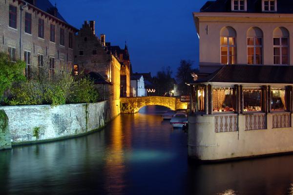
At the end of the 14th century, Bruges became one of the Four Members, along with Franc of Bruges, Ghent and Ypres. Together they formed a parliament, however they frequently quarrelled amongst themselves.
In the 15th century, Philip the Good, duke of Burgundy, set up court in Bruges, as well as Brussels and Lille, attracting a number of artists, bankers, and other prominent personalities from all over Europe. The weavers and spinners of Bruges were thought to be the best in the world, and the population of Bruges grew to 200,000 inhabitants at this time. This is also the time when Edward IV and Richard III of England spent time in exile here.
In the 15th century, Philip the Good, duke of Burgundy, set up court in Bruges, as well as Brussels and Lille, attracting a number of artists, bankers, and other prominent personalities from all over Europe. The weavers and spinners of Bruges were thought to be the best in the world, and the population of Bruges grew to 200,000 inhabitants at this time. This is also the time when Edward IV and Richard III of England spent time in exile here.
In the last half of the 19th century, Bruges became one of the world's first tourist destinations attracting wealthy British and French tourists. By 1909 it had in operation an association called 'Bruges Forward: Society to Improve Tourism.' After 1965 the original medieval city experienced a renaissance. Restorations of residential and commercial structures, historic monuments, and churches generated a surge in tourism and economic activity in the ancient downtown area. International tourism has boomed, and new efforts have resulted in Bruges being designated 'European Capital of Culture' in 2002. It attracts some 2 million tourists annually.
The port of Zeebrugge was built in 1907. The Germans used it for their U-boats in World War I. It was greatly expanded in the 1970s and early 1980s and has become one of Europe's most important and modern ports.
The port of Zeebrugge was built in 1907. The Germans used it for their U-boats in World War I. It was greatly expanded in the 1970s and early 1980s and has become one of Europe's most important and modern ports.
Restaurants are not always cheap or wonderfu in Bruges, although mussels and frites or fricadellen, frites with mayonnaise are outstanding here. Stay away from the central market place ("Grote Markt") and the Burg Square (e.g. the Tom Pouce Restaurant) when eating. Tourists are easy victims here. One tactic used by tourist traps is to present items (e.g. bread) as if they were free with your meal, then charge you exorbitantly for them. Even water may be charged at an exorbitant €6 for a small bottle.
You will, however, find great food if you wander off the beaten track. Find a street with more locals than tourists and ask somebody. The locals will be glad to help.
You will, however, find great food if you wander off the beaten track. Find a street with more locals than tourists and ask somebody. The locals will be glad to help.

Bruges’ Top 5:
- The Church of Our Lady dates mainly from the 13th, 14th and 15th centuries. Its tower, at 122.3 meters in height, remains the tallest structure in the city and the second tallest brickwork tower in the world (the tallest being the St. Martin's Church in Landshut, Germany). In the choir space behind the high altar are the tombs of Charles the Bold, last Valois Duke of Burgundy, and his daughter, the duchess Mary. The gilded bronze effigies of both father and daughter repose at full length on polished slabs of black stone. Both are crowned, and Charles is represented in full armor and wearing the decoration of the Order of the Golden Fleece. The altarpiece of the large chapel in the southern aisle enshrines the most celebrated art treasure of the church—a white marble sculpture of the Madonna and Child created by Michelangelo around 1504. Probably meant originally for Siena Cathedral, it was purchased in Italy by two Brugean merchants, the brothers Jan and Alexander Mouscron, and in 1514 donated to its present home. The sculpture was twice recovered after being looted by foreign occupiers—French revolutionaries circa 1794 and Nazi Germany in 1944.
- The Belfry of Bruges, or Belfort, is a medieval bell tower in the historical centre of Bruges. One of the city's most prominent symbols, the belfry formerly housed a treasury and the municipal archives, and served as an observation post for spotting fires and other danger. A narrow, steep staircase of 366 steps, accessible by the public for an entry fee, leads to the top of the 83-metre-high building, which leans about a metre to the east. To the sides and back of the tower stands the former market hall, a rectangular building only 44 m broad but 84 m deep, with an inner courtyard. The belfry, accordingly, is also known as the Halletoren (tower of the halls).
- The Groeningemuseum is a municipal museum of Bruges. It houses a comprehensive survey of six centuries of Flemish and Belgian painting, from Jan van Eyck to Marcel Broodthaers. The museum's many highlights include its collection of "Flemish Primitive" art, works by a wide range of Renaissance and Baroque masters, as well as a selection of paintings from the 18th and 19th century neo-classical and realist periods, milestones of Belgian symbolism and modernism, masterpieces of Flemish expressionism and many items from the city's collection of post-war modern art.
- The Sint-Salvator Cathedral, the main church of the city, is one of the few buildings in Bruges that have survived the onslaught of the ages without damage. Nevertheless, it has undergone some changes and renovations. This church was not originally built to be a cathedral; it was granted the status in the 19th century. Since the 10th century the Sint-Salvator was a common parish church. At that time the St Donatian's Cathedral, which was located at the very heart of Bruges, opposite of the town hall, was the central religious building of the city. At the end of the 18th century the French occupiers of Bruges threw out the bishop of Bruges and destroyed the Sint-Donatius Church, which was his residence. In 1834, shortly after Belgium's independence in 1830, a new bishop was installed in Bruges and the Sint-Salvator church obtained the status of cathedral. However, the buildings external image did not resemble a cathedral back then: it was much smaller and less imposing than the nearby Onze-Lieve-Vrouwekerk and had to be adapted to its new role. Building a higher and more impressive tower was one of the viable options.
- The Basilica of the Holy Blood is a Roman Catholic minor basilica. Originally built in the 12th century as the chapel of the residence of the Count of Flanders, the church houses a venerated relic of the Holy Blood allegedly collected by Joseph of Arimathea and brought from the Holy Land by Thierry of Alsace, Count of Flanders. Built between 1134 and 1157, it was promoted to minor basilica in 1923. The 12th-century basilica is located in the Burg square and consists of a lower and upper chapel. The lower chapel dedicated to St. Basil the Great is a dark Romanesque structure that remains virtually unchanged. The venerated relic is in the upper chapel, which was rebuilt in the Gothic style during the 16th century and renovated multiple times during the 19th century in Gothic Revival style.


Brussels

Brussels is the capital of Belgium and the de facto capital of the European Union (EU). It is also the largest urban area in Belgium, comprising 19 municipalities, including the municipality of the City of Brussels, which is the de jure capital of Belgium, in addition to the seat of the French Community of Belgium and of the Flemish Community. Brussels has grown from a 10th-century fortress town founded by a descendant of Charlemagne into a metropolis of more than one million inhabitants. The metropolitan area has a population of over 1.8 million, making it the largest in Belgium. Since the end of the Second World War, Brussels has been a main centre for international politics. Hosting principal EU institutions as well as the headquarters of the North Atlantic Treaty Organization (NATO), the city has become the home of numerous international organisations, politicians, diplomats and civil servants.
Although historically Dutch-speaking, Brussels became increasingly French-speaking over the 19th and 20th centuries. Today a majority of inhabitants are French-speakers, including a significant population of immigrants with French as second language, and both languages have official status. Linguistic tensions remain, and the language laws of the municipalities surrounding Brussels are an issue of considerable controversy in Belgium.
 |
| The Manneken Pis |
Throughout the ages, Brussels has seen a number of fortifications come and go, the first walls, built in the early 13th century, and the second walls, built in the late 14th century and later upgraded. Today, only a few sections of either remain. Construction on the first walls of Brussels is estimated to have been at the beginning of the 13th century, under the reign of Henry I, the first Duke of Brabant. The beginning and end dates are not clear, but construction would have lasted several decades. On the other hand, from historical maps and other documents that have been preserved, the precise former course of the walls is known. The walls were initially made of earth, with a wooden fence on top. These gave way to walls made of stone that were 10 metres (33 ft) tall and 1 to 2.5 metres (3 to 8 ft) thick. A large ditch was dug in front of the walls, and in places this could be flooded with water to form a moat if needed. Along the length of the walls, there were roughly 40 defensive towers, in addition to seven primary gates and five smaller entrances.
 |
| Remains of city walls |
Brussels is known for its local waffle, its chocolate, its French fries and its numerous types of beers. The Brussels sprout was first cultivated in Brussels, hence its name. The gastronomic offer includes approximately 1,800 restaurants, and a number of high quality bars. Belgian cuisine is known among connoisseurs as one of the best in Europe. In addition to the traditional restaurants, there is a large number of cafés, bistros, and the usual range of international fast food chains. The cafés are similar to bars, and offer beer and light dishes; coffee houses are called the Salons de Thé. Also widespread are brasseries, which usually offer a large number of beers and typical national dishes. Belgian cuisine is characterised by the combination of French cuisine with the more hearty Flemish fare. Notable specialities include Brussels waffles (gaufres) and mussels (usually as "moules frites", served with fries). The city is a stronghold of chocolate and pralines manufacturers with renowned companies like Neuhaus, Leonidas and Godiva. Numerous friteries are spread throughout the city, and in tourist areas, fresh, hot, waffles are also sold on the street.
The city has had a renowned artist scene for many years. The famous Belgian surrealist René Magritte, for instance, studied in Brussels. The city was also home of Impressionist painters like Anna Boch from the Artist Group Les XX. The city is also a capital of the comic strip; home to some treasured Belgian characters such as Lucky Luke and Tintin, Throughout the city, walls are painted with large motifs of comic book characters. The totality of all these mural paintings is known as the Brussels' Comic Book Route. Also, the interiors of some Metro stations are designed by artists. The Belgian Comics Museum combines two artistic leitmotifs of Brussels, being a museum devoted to Belgian comic strips, housed in the former Waucquez department store, designed by Victor Horta in the Art Nouveau style.
Brussels contains over 80 museums, including the Museum of Modern Art, and the Royal Museums of Fine Arts of Belgium. The museum has an extensive collection of various painters, such as the Flemish painters like Bruegel, Anthony van Dyck, and Jacob Jordaens. The recently opened Magritte Museum houses the world's largest collection of the works of the surrealist René Magritte.
 |
| The St. Michael and St. Gudula Cathedral |
Brussels’s Top 5:
- The Grand Place is the central square of Brussels. It is surrounded by guildhalls, the city's Town Hall, and the Breadhouse. The square is the most important tourist destination and most memorable landmark in Brussels. It measures 68 by 110 metres (223 by 360 ft), and it is a UNESCO World Heritage Site. Improvements to the Grand Place from the 14th century onwards would mark the rise in importance of local merchants and tradesmen relative to the nobility. The city of Brussels, as with the neighbouring cities of Mechelen and Leuven constructed a large indoor cloth market to the south of the square. At this point, the square was still haphazardly laid out, and the buildings along the edges had a motley tangle of gardens and irregular additions. The city expropriated and demolished a number of buildings that clogged the Grand Place, and formally defined the edges of the square. Every two years in August, an enormous "flower carpet" is set up in the Grand Place for a few days. A million colourful begonias are set up in patterns, and the display covers a full 24 by 77 metres (79 by 253 ft), for area total of 1,800 square metres (19,000 sq ft). The first flower carpet was made in 1971, and due to its popularity, the tradition continued, with the flower carpet attracting a large number of tourists.
- The Royal Castle of Laeken is the official residence of the King of the Belgians.
The castle was built at Laeken between 1782-1784 after the plans of the French architect Charles de Wailly under supervision of Louis Montoyer as a summer residence for the Governors of the Habsburg Netherlands. On 21 July 1803, Nicolas-Jean Rouppe, as commissioner of the department of the Dijle, received Napoleon at the Castle of Laeken. Napoleon stayed here with his Empress in August 1804 on his way from awarding the first Légion d'honneur to his invasion troops at Boulogne to his progress along the Rhine, and later (on invading Belgium during the Hundred Days War in 1815) dated this proclamation prematurely from the palace. - Manneken Pis. (literally Little Man Pee in Marols, a Dutch dialect spoken in Brussels, also known in French as le Petit Julien), is a famous Brussels landmark. It is a small bronze fountain sculpture depicting a naked little boy urinating into the fountain's basin. It was designed by Jerome Duquesnoy and put in place in 1618 or 1619. It bears a similar cultural significance as Copenhagen's Little Mermaid. The famous statue is located at the junction of Rue de l'Étuve/Stoofstraat and Rue du Chêne/Eikstraat. To find it, one takes the left lane next to the Brussels Town Hall from the famous Grand Place and walks a few hundred metres to arrive at the spot. The statue will be on the left corner. The 61 cm tall bronze statue on the corner of Rue de l'Etuve and Rue des Grands Carmes was made in 1619 by Brussels sculptor Hieronimus Duquesnoy. The figure has been repeatedly stolen; the current statue is a copy from 1965. The original is kept at the Maison du Roi/Broodhuis on the Grand Place. There are several legends behind this statue, but the most famous is the one about Duke Godfrey III of Leuven. In 1142, the troops of this two-year-old lord were battling against the troops of the Berthouts, the lords of Grimbergen, in Ransbeke (now Neder-over-Heembeek). The troops put the infant lord in a basket and hung the basket in a tree to encourage them. From there, the boy urinated on the troops of the Berthouts, who eventually lost the battle.
- The St. Michael and St. Gudula Cathedral is a Roman Catholic church on the Treurenberg hill. In 1047, Lambert II, Count of Leuven founded a chapter in this church and organized the transportation of the relics of Saint Gudula, housed before then in Saint Gaugericus Church on Saint-Géry Island. The patron saints of the church, archangel St. Michael and the martyr St. Gudula, are also the patron saints of the city of Brussels. In the thirteenth century, the cathedral was renovated in the Gothic style. The choir was constructed between 1226 and 1276. The façade was completed in the mid-fifteenth century. It is an archiepiscopal cathedral of the Archbishop of Mechlin-Brussels, the Primate of Belgium, currently Archbishop André-Mutien Léonard. It is located in the national capital and therefore often used for Catholic ceremonies of national interest, such as royal marriages and state funerals.
- The Atomium is a monument, originally built for Expo '58, the 1958 Brussels World's Fair. Designed by André Waterkeyn and Les Architectes Polak, it stands 102 metres (335 ft) tall. It has nine steel spheres connected so that the whole forms the shape of a unit cellof an iron crystal magnified 165 billion times. Tubes connect the spheres along the 12 edges of the cube and all eight vertices to the centre. They enclose escalators connecting the spheres containing exhibit halls and other public spaces. The top sphere provides a panoramic view of Brussels. Each sphere is 18 metres in diameter. Three spheres are currently (2008) closed to visitors, others can be reached easily by escalators. The vertical vertex contains a lift which was very fast and advanced at the time of building (the speed is 5 m/s). The Atomium is one of the most visited attractions in Brussels today.

The Atomium


References: http://visitbrussels.be
Bucharest

Bucharest is the capital city and the commercial centre of Romania. It is located in the southeast of the country, on the banks of the Dâmbovita River. The city was first mentioned in 1459 and became the capital of Romania in 1862. Since then, it has gone through a variety of changes and has become the centre of the Romanian mass media, cultural and arts scene. Its eclectic architecture, which is a mix of historical, Ceausescu-era and modern, also reflects the city's varied history. In the period between the two World Wars, the city's elegant architecture and the sophistication of its elite gave Bucharest the nickname of the "Paris of the East" or "Little Paris". Although much of the historic center was damaged or destroyed by war, earthquakes and Nicolae Ceausescu's program of systematization, much survived, and in our days the city is experiencing an economic and cultural boom.
 |
| The Romanian Athenaeum |
Bucharest has a diverse and growing cultural scene, with cultural life exhibited in a number of various fields, including the visual arts, performing arts and nightlife. Unlike other parts of Romania, such as the Black Sea coast or Transylvania, Bucharest's cultural scene is much more eclectic, without a defined style, and instead incorporates various elements of Romanian and international culture. Bucharest has an eclectic mixture of elements from traditionally Romanian buildings to buildings that are influenced by French architects.
 |
| Arcul de Triumf |
Traditional Romanian culture continues to have a major influence in arts such as theatre, film and music. Bucharest has two internationally-renowned ethnographic museums, the Museum of the Romanian Peasant and the open-air Village Museum. The Village Museum, in Herăstrău Park, contains 272 authentic buildings and peasant farms from all over Romania. The Museum of the Romanian Peasant was declared the European Museum of the Year in 1996, and displays a rich collection of textiles (especially costumes), icons, ceramics, and other artifacts of Romanian peasant life.
The Museum of Romanian History is another important museum in Bucharest, containing a collection of artefacts detailing Romanian history and culture from the prehistoric times, Dacian era, medieval times and the modern era.
The Museum of Romanian History is another important museum in Bucharest, containing a collection of artefacts detailing Romanian history and culture from the prehistoric times, Dacian era, medieval times and the modern era.
 |
| Lipscani |
Of the city's medieval architecture, most of what survived into modern times was destroyed by Communist systematization, numerous fires and military incursions. Still, some medieval and renaissance edifices remain, the most notable are in the Lipscani area. This precinct contains notable buildings such as Manuc's Inn and the ruins of the Curtea Veche (the Old Court), during the late Middle Ages this area was the heart of commerce in Bucharest. From the 1970s onwards, the area went through urban decline, and many historical buildings fell into disrepair. In 2005, the Lipscani area was entirely pedestrianised and is currently slowly undergoing restoration.
The city centre has also retained architecture from the late 19th and early 20th centuries, particularly the interwar period, which is often seen as the "golden age" of Bucharest architecture. During this time, the city grew significantly in size and wealth therefore seeking to emulate other large European capitals such as Paris. Much of the architecture of the time belongs to a remarkably strong Modern (rationalist) Architecture current, led by Horia Creanga and Marcel Iancu, which managed to literally change the face of the city.
The city centre has also retained architecture from the late 19th and early 20th centuries, particularly the interwar period, which is often seen as the "golden age" of Bucharest architecture. During this time, the city grew significantly in size and wealth therefore seeking to emulate other large European capitals such as Paris. Much of the architecture of the time belongs to a remarkably strong Modern (rationalist) Architecture current, led by Horia Creanga and Marcel Iancu, which managed to literally change the face of the city.
Bucharest’s Top 5:
- The Palace of the Parliament. A multi-purpose building containing both chambers of the Romanian Parliament. According to theWorld Records Academy, the Palace is the world's largest civilian building, most expensive administrative building, and heaviest building. The Palace was designed and nearly completed by the Ceaușescu regime as the seat of political and administrative power. Nicolae Ceaușescu named it the House of the Republic, but most Romanians call it the People's House. Built on the site of a hill which was largely razed for this megaproject, the building anchors the west end of Bulevardul Unirii and Centrul Civic. Constructing the Palace and Centrul Civic required demolishing much of Bucharest's historic district, including 19 Orthodox Christian churches, six Jewish synagogues, three Protestant churches (plus eight relocated churches), and 30,000 residences. Construction began in 1983; the cornerstone was laid on 25 June 1984. While the building was intended to house all four major state institutions (in a similar manner to the UK Houses of Parliament), Ceausescu intended the palace to be his personal residence and the government was to operate within it.
- Arcul de Triumf is a triumphal arch located in the northern part of Bucharest, on the Kiseleff Road. The first, wooden, triumphal arch was built hurriedly, after Romania gained its independence in 1878, so that the victorious troops could march under it. Another temporary arch was built on the same site, in 1922, after World War I, which was demolished in 1935 to make way for the current triumphal arch, which was inaugurated in September 1936. The current arch has a height of 27 metres and was built after the plans of the architect Petre Antonescu. It has as its foundation a 25 x 11.50 metres rectangle. The sculptures with which the facades are decorated were created by famous Romanian sculptors such as Ion Jalea and Dimitrie Paciurea. Nowadays, military parades are held beneath the arch each 1 December, with the occasion of Romania's national day.
- The Memorial of Rebirth. Is a memorial that commemorates the struggles and victims of the Romanian Revolution of 1989, which overthrew Communism. The memorial complex was inaugurated in August 2005 in Revolution Square, where Romania's Communist-era dictator, Nicolae Ceauşescu, was publicly overthrown in December 1989. The memorial, designed by Alexandru Ghilduş, features as its centrepiece a 25-metre-high marble pillar reaching up to the sky, upon which a metal "crown" is placed. The pillar is surrounded by a 600 m² plaza covered by marble and granite. Its initial name was "Eternal Glory to the Heroes and the Romanian Revolution of December 1989" . The memorial's name alludes to Romania's rebirth as a nation after the collapse of Communism.
- The Romanian Athenaeum. Is a significant landmark of the Romanian capital city. Opened in 1888, the ornate, domed, circular building is the city's main concert hall and home of the"George Enescu" Philharmonic and of the George Enescu annual international music festival. In 1865, cultural and scientific personalities such as Constantin Esarcu, V. A. Urechia, and Nicolae Creţulescu founded the Romanian Atheneum Cultural Society. To serve its purposes, the Romanian Athenaeum, a building dedicated to art and science, would be erected in Bucharest. The building was designed by the French architect Albert Galleron, built on a property that had belonged to the Văcărescu family and inaugurated in 1888, although work continued until 1897. A portion of the construction funds was raised by public subscription in a 28-year long effort, of which the slogan is still remembered today: "Donate one Leu for the Ateneu!"
The National Museum of Art of Romania. is located in the former royal palace in Revolution Square, completed in 1937. It features notable collections of medieval and modern Romanian art, as well as the international collection assembled by the Romanian royal family. The museum was damaged during the 1989 Romanian Revolution. In 2000, part of the museum reopened to the public, housing the modern Romanian collection and the international collection; the comprehensive Medieval art collection, which now features works salvaged from monasteries destroyed during the Ceauşescu era, reopened in spring 2002. There are also two halls that house temporary exhibits. The international collection includes works by Old Masters such as Domenico Veneziano, El Greco, Tintoretto, Jan van Eyck, Jan Brueghel the Elder, Peter Paul Rubens, and Rembrandt, plus a smattering of works by impressionists such as Claude Monet and Alfred Sisley. Among the most famous Old Master works in the collection are Jacopo Amigoni's portrait of the singer Farinelli, a Crucifixion by Antonello da Messina, and Alonso Cano's Christ at the Column.
The National Museum of Art of Romania


Budapest

Budapest is the capital and largest city of Hungary, it is the country's principal political, cultural, commercial, industrial, and transportation centre. Budapest became a single city occupying both banks of the river Danube with a unification on 17 November 1873 of west-bank Buda and Óbuda with east-bank Pest.
The history of Budapest began with Aquincum, originally a Celtic settlement that became the Roman capital of Lower Pannonia. Hungarians arrived in the territory in the 9th century. Their first settlement was pillaged by the Mongols in 1241-42. The re-established town became one of the centres of Renaissance humanist culture in the 15th century. Following the Battle of Mohács and nearly 150 years of Ottoman rule, development of the region entered a new age of prosperity in the 18th and 19th centuries, and Budapest became a global city after the 1873 unification. It also became the second capital of Austria-Hungary, a great power that dissolved in 1918. Budapest was the focal point of the Hungarian Revolution of 1848, the Hungarian Soviet Republic of 1919.

Cited as one of the most beautiful cities in Europe, its extensive World Heritage Site includes the banks of the Danube, the Buda Castle Quarter, Andrássy Avenue, Heroes' Square and the Millennium Underground Railway, the second oldest in the world. The city attracts about 2.7 million tourists a year.
Similarly to other Central European capitals, Budapest offers wonderful cultural experiences to visitors and locals alike. With an abundance of concert halls, churches, museums, cinemas and a bustling nightlife, the city is a popular destination all year round.
One of the reasons the Romans first colonized the area immediately to the west of the River Danube and established their regional capital at Aquincum (now part of Óbuda, in northern Budapest) is so that they could utilize and enjoy the thermal springs. There are still ruins visible today of the enormous baths that were built during that period. The new baths that were constructed during the Turkish period (1541–1686) served both bathing and medicinal purposes, and some of these are still in use to this day. Budapest gained its reputation as a city of spas in the 1920s, following the first realization of the economic potential of the thermal waters in drawing in visitors. Indeed, in 1934 Budapest was officially ranked as a "City of Spas". Today, the baths are mostly frequented by the older generation, as, with the exception of the “Magic Bath” and "Cinetrip" water discos, young people tend to prefer the lidos which are open in the summer. Construction of the Király Baths started in 1565, and most of the present-day building dates from the Turkish period, including most notably the fine cupola-topped pool.
Similarly to other Central European capitals, Budapest offers wonderful cultural experiences to visitors and locals alike. With an abundance of concert halls, churches, museums, cinemas and a bustling nightlife, the city is a popular destination all year round.
 |
| St Stephens |
 |
| Buda Castle |
Buapest’s Top 5:
- The Parliament Building. Built between 1885 and 1904 the Parliament building soon became the symbol of the Hungarian capital. Not just because of its sheer size – nearly 18000 square metres – but because of its detailed decoration, inside splendour and eclectic diversity. It is the most expensive building ever built in Hungary. It has 691 rooms, 10 courtyards, 27 gates and 29 staircases. It also houses a public library with 500.000 volumes. The walls from outside are decorated by the statues of the most important historical figures of Hungary. Until the 19th century the Hungarian diet held its sessions on various places in the country, depending on which part was not under occupation or foreign rule. After the Austro-Hungarian Compromise in 1867, Hungary received more independence and it's own constitution. The establishment of a parliament building was also initiated.
- St Stephen's Basilica. The church is named for Saint Stephen I of Hungary, the first King of Hungary (c. 975–1038), whose incorruptible right hand is housed in the reliquary. This is the most important church building in Hungary, one of the most significant tourist attractions and the third highest building in Hungary. The architectural style is Neo-Classical; it has a Greek cross ground plan. The façade is anchored by two large bell towers. In the southern tower is Hungary's biggest bell, weighing over 9 tonnes
- Matthias Church. is a church located in the heart of Buda's Castle District. According to church tradition, it was originally built in Romanesque style in 1015. The current building was constructed in the florid late Gothic style in the second half of the 14th century and was extensively restored in the late 19th century. It was the second largest church of medieval Buda and the seventh largest church of medieval Hungarian Kingdom.
- Buda Castle. is the historical castle and palace complex of the Hungarian kings in Budapest, first completed in 1265. In the past, it was also called Royal Palace and Royal Castle. Buda Castle was built on the southern tip of Castle Hill, bounded on the north by what is known as the Castle District (Várnegyed), famous for its Medieval, Baroque and 19th century houses, churches and public buildings. It is linked to Clark Ádám Square and the Széchenyi Chain Bridge by the Castle Hill Funicular.
- Hősök tere or Heroes' Square. is one of the major squares rich with historic and political connotations. Its iconic statue complex, the Millennium Memorial, was completed in 1900, the same year the square was named "Heroes' Square". It lies at the end of Andrássy Avenue (with which it comprises part of an extensive World Heritage site), next to City Park. During the Hungarian Soviet Republic in 1919 the Millennium Monument was completely covered by red textile and at the basement of the obelisk a new statue was erected: Marx with a worker and a peasant. The statues of Hungarian historic national heroes were toppled. The Hungarian national symbols were banned in the name of internationalism. Hősök tere is surrounded by two important buildings, Museum of Fine Arts on the left and Palace of Art (or more accurately Hall of Art) on the right. On the other side it faces Andrássy Avenue which has two buildings looking at the square — one is residential and the other one is the embassy of Serbia (former Yugoslavian embassy where Imre Nagy secured sanctuary in 1956).

Heroes Square


References: http://www.budapestinfo.org/sights.html
No comments:
Post a Comment