Translate

Saturday 29 September 2012

Stavanger

Stavanger


Stavanger is a city and municipality in Norway. Although the fourth largest city, Stavanger is the third largest urban zone in Norway and the administrative centre of Rogaland county. Located on the Stavanger peninsula in Southwest Norway, Stavanger counts its official founding year as 1125, the year the Stavanger cathedral was completed. Stavanger's core is to a large degree 17th and 18th century wooden houses that are considered part of the city's cultural heritage and these are hence protected. This has caused the town centre and inner city to retain a small-town character, and even after the city's rapid growth in the 1970s onwards, the urbanization of the city center has been limited and a large share of the population still lives in detached houses.

The city's rapid population growth in the late 1900s was primarily a result of Norway's booming offshore oil industry. Today the oil industry is a key industry in the Stavanger region and the city is widely referred to as the Oil Capital of Norway. The largest company in the Nordic region, Norwegian energy company Statoil is headquartered in Stavanger. 

The first traces of settlement in the Stavanger region come from the days when the ice retreated after the last ice age ca. 10,000 years ago. A number of historians have argued convincingly that North-Jæren was an economic and military centre as far back as the 9th-10th century with the consolidation of the nation at the Battle of Hafrsfjord around 872. Stavanger grew into a centre of church administration and an important south-west coast market town around 1100–1300.

Stavanger fulfilled an urban role prior to its status as city (1125), from around the time the Stavanger bishopric was established in the 1120s. Bishop Reinald, who may have come from Winchester, England, is said to have started construction of Stavanger Cathedral (Stavanger domkirke) around 1100. It was finished around 1125, and the city of Stavanger counts 1125 as its year of foundation.

With the Protestant Reformation in 1536, Stavanger's role as a religious centre declined, and the establishment of Kristiansand in the early 17th century led to the relocation of the bishopric. However, rich herring fisheries in the 19th century gave the city new life. Stavanger was established as a municipality 1 January 1838. The then rural municipalities of Hetland and Madla merged with Stavanger 1 January 1965.

The city's history is a continuous alternation between economic booms and recessions. For long periods of time its most important industries have been shipping, shipbuilding, the fish canning industry and associated subcontractors.

In 1969, a new boom started as oil was first discovered in the North Sea. After much discussion, Stavanger was chosen to be the on-shore center for the oil industry on the Norwegian sector of the North Sea, and a period of hectic growth followed.

The modern day city centre is small and intimate, with narrow streets and open spaces protected from car traffic. The open-air vegetable market is one of the very few in Norway where you can buy produce directly from local farmers every working day through the year. Unfortunately the Market has been in decline of recent years, it is now filled with very few stall holders.

Stavanger and its region, along with Liverpool, United Kingdom, was selected as a European Capital of Culture for 2008. The Stavanger2008 vision is expressed through the concept "Open Port". This can be understood both in its English sense - "an open harbour", - and in its Norwegian meaning of "an open gate". Open Port – Openness towards the world. The region and its people is supposed to be even more open and inclusive towards art, ideas and opportunities.

Every May, Stavanger is host to MaiJazz, the Stavanger International Jazz Festival. The International Chamber Music Festival takes place every August. Stavanger was the host port of the Cutty Sark Tall Ships' Race in 1997 and 2004.

The Stavanger Region is famous for its culinary diversity. The area is particularly known for shellfish, dairy and meat products, vegetables, especially tomatoes, cucumbers, parsley and potatoes, and fruit. Why not make a stop at Voll Ysteri, a small dairy that produces the Jæren cheese raclette?

The Stavanger Region is home to the Gastronomic Institute of Norway, and also Måltidets Hus, the national centre for food-related professions.


                                                       Stavanger’s Top 5:
       
  1. Stavanger Cathedral (Stavanger domkirke) is Norway's oldest cathedral. It is situated in the middle of Stavanger, and is the seat of the Diocese of Stavanger. Bishop Reinald, who may have come from Winchester, is said to have started construction of the Cathedral around 1100. It was finished around 1150, and the city of Stavanger counts 1125 as its year of foundation. The Cathedral was consecrated to Swithin as its patron saint. Saint Swithun was an early Bishop of Winchester and subsequently patron saint of Winchester Cathedral. Stavanger was ravaged by fire in 1272, and the Cathedral suffered heavy damage. It was rebuilt under bishop Arne, and the Romanesque Cathedral was enlarged in the Gothic style. In 1682, king Christian V decided to move Stavanger's episcopal seat to Kristiansand. However, on Stavanger's 800th anniversary in 1925, king Haakon VII instated Jacob Christian Petersen as Stavanger's first bishop in nearly 250 years. During a renovation in the 1860s, the Cathedral's exterior and interior was considerably altered. The stone walls were plastered, and the Cathedral lost much of its medieval looks. A major restoration led by Gerhard Fischer in 1939-1964 partly reversed those changes. The latest major restoration of the Cathedral was conducted in 1999. Andrew Lawrenceson Smith is famous for his works here.
  2. Stavanger Museum is a museum of natural and cultural history established in 1877, located in the Norwegian city Stavanger. The museum's collections consist of several departments: the department of zoology, the department for cultural history (which also includes custodianship of the royal residence Ledaal). Departments include the Stavanger Museum of Natural History, Stavanger Maritime Museum, Norwegian Children's Museum, Norwegian Printing Museum, Stavanger School Museum, Stavanger Art Museum, and Norwegian Canning Museum.
  3. Preikestolen or Prekestolen, also known by the English translations of Preacher's Pulpit or Pulpit Rock, and by the old local name Hyvlatonnå (“the carpenter-plane’s blade”), is a massive cliff 604 metres (1982 feet) above Lysefjorden, opposite the Kjerag plateau, in Forsand, Ryfylke, Norway. The top of the cliff is approximately 25 by 25 metres (82 by 82 feet), almost flat, and is a famous tourist attraction in Norway.
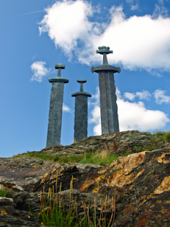
    The tourism at the site has been increasing, around 2012, the plateau was each year visited by between 150,000 and 200,000 people who took the 3.8 km (2.4 mi.) hike to Preikestolen, making it one of the most visited natural tourist attractions in Norway.
  4. The Three Swords (Sverd i Fjell) stand on the edge of Hafrsfjord, 6km from the centre of Stavanger. The monument is a popular backdrop for civil wedding ceremonies. The monument was unveiled by King Olav in 1983 and commemorates the Battle of Hafrsfjord in 872, after which King Harald Fair Hair united the three districts of Norway into one kingdom.The crowns on the swords represent the different districts which took part in the battle.
  5. Gamle Stavanger ('Old Stavanger') is an area of the city of Stavanger, and is believed to be Europe's largest collection of wooden buildings. The area includes the Norwegian Canning museum which displays a typical factory from the 1920s. In the years after World War II, a new city plan was created for Stavanger. It included razing most of the old wooden buildings in the city centre, and replacing it with new modern structures in concrete. One single voice spoke up against this plan, and today it is recognized that Gamle Stavanger owes its existence to Einar Hedén, then City Architect of Stavanger. In 1956 the city council voted to conserve part of the old city centre. The area selected for conservation was the one considered the least desirable, consisting of small rundown wooden buildings located on the western side of Vågen. This area has what is considered North Europe's best kept wood houses, from both the 19th and 20th century. Some of the houses are owned by the municipality, but most are privately owned. Over the years the area has changed from seedy to trendy, and today is considered a choice location for the urban-minded with a sense of history. On two occasions Gamle Stavanger has grown, so that it now covers more than 250 buildings.


Friday 28 September 2012

St Petersburg

St Petersburg


Saint Petersburg is a city and a federal subject (a federal city) of Russia located on the Neva River at the head of the Gulf of Finland on the Baltic Sea. In 1914 the name of the city was changed to Petrograd, in 1924 to Leningrad and in 1991 back to Saint Petersburg.

Nyenskans, a Swedish fortress, was founded at the mouth of the Neva River in 1611, in a land then called Ingermanland. A small town called "Nyen" grew up around it.

Peter the Great was interested in seafaring and maritime affairs, and he aimed to have Russia gain an ability to take to the seas, so it could trade with other maritime nations. In order to do so, he needed a better seaport than Arkhangelsk, which was on the White Sea to the north.

On May 12 1703, during the Great Northern War, Peter the Great captured Nyenskans, and soon set about replacing that fortress. On May 27 1703, closer to the estuary (5 km/3 miles inland from the gulf), on Zayachy (Hare) Island, he laid down the Peter and Paul Fortress, which became the first brick and stone building of the new city.

The city was built by conscripted peasants from all over Russia; a number of Swedish prisoners of war were also involved in some years under the supervision of Alexander Menshikov. Tens of thousands of serfs died building the city. Later the city became the centre of Saint Petersburg Governorate. Peter moved the capital from Moscow to Saint Petersburg in 1712, 9 years before the Treaty of Nystad of 1721 ended the war, although he was already referring to Saint Petersburg as the capital (or seat of government) as early as 1704.

During the first few years of its existence the city grew spontaneously around Trinity Square on the right bank of the Neva, near the Peter and Paul Fortress. However, Saint Petersburg soon started to develop according to a plan. By 1716 Domenico Trezzini had elaborated a project whereby the city centre would be located on Vasilyevsky Island and shaped by a rectangular grid of canals. The project was not completed, but is still evident in the layout of the streets. In 1716 Jean-Baptiste Alexandre Le Blond was appointed chief architect of Saint Petersburg by Peter the Great.

In 1725, Peter died at the age of fifty-two. His push for modernization of Russia had met opposition from the Russian nobility — resulting in several attempts on his life and a treason case involving his own son. Thus, in 1728, Peter II of Russia moved his seat back to Moscow. But four years later, in 1732, under Empress Anna of Russia, Saint Petersburg again became the capital of the Russian Empire. It remained the seat of the Romanov Dynasty and the Imperial Court of the Russian Tzars, as well as the seat of the Russian government, for another 186 years until the communist revolution of 1917.

In 1736–1737 the city suffered from catastrophic fires. To rebuild the damaged boroughs, a new plan was commissioned in 1737 by a committee under Burkhard Christoph von Münnich. The city was divided into five boroughs, and the city center was moved to the Admiralty borough, situated on the east bank between the Neva and Fontanka.

It developed along three radial streets, which meet at the Admiralty building and are now known as Nevsky Prospekt (which is now perceived as the main street of the city), Gorokhovaya Street and Voznesensky Prospekt. A Baroque style dominated the city architecture during the first sixty years, culminating in the Elizabethan Baroque, represented most notably by Bartolomeo Rastrelli with such buildings as the Winter Palace. In the 1760s Baroque architecture was succeeded by neoclassical architecture.

The Commission of Stone Buildings of Moscow and Saint Petersburg established in 1762 ruled that no structure in the city be higher than the Winter Palace and prohibited spacing between buildings. During the reign of Catherine the Great in the 1760s–1780s, the banks of the Neva were lined with granite embankments.

However, it was not until 1850 that the first permanent bridge across the Neva, Blagoveshchensky Bridge, was allowed to open. Before that, only pontoon bridges were allowed. Obvodny Canal (dug in 1769–1833) became the southern limit of the city.

With the emancipation of the peasants undertaken by Alexander II in 1861 and an industrial revolution, the influx of former peasants into the capital increased greatly. Poor boroughs spontaneously emerged on the outskirts of the city. Saint Petersburg surpassed Moscow in population and industrial growth and grew into one of the largest industrial cities in Europe, with a major naval base (in Kronstadt), river and sea port.

The names of saints Peter and Paul, bestowed upon original city's citadel and its cathedral (from 1725 – a burial vault of Russian emperors) coincidentally were mirrored by the names of the first two assassinated Russian Emperors, Peter III (1762, supposedly a conspiracy led by his wife, Catherine the Great) and Paul I (1801, Nicholas Zubov and other conspirators who brought to power Alexander I, the son of their victim). The third emperor's assassination took place in Petersburg in 1881 when Alexander II fell victim of narodniki (see the Church of the Savior on Blood). 


The Revolution of 1905 began in Saint Petersburg and spread rapidly into the provinces.

During World War I, the city was renamed Petrograd, meaning "Peter's City", to remove the German word "burg."

In March 1917, during the February Revolution Nicholas II abdicated both for himself and on behalf of his son, thus putting an end to the Russian monarchy and over three hundred years of Romanov dynastic rule.

On 7 November 1917, the Bolsheviks, led by Vladimir Lenin, stormed the Winter Palace in an event known thereafter as the Great October Socialist Revolution, which led to the end of the post-Tsaristprovisional government, the transfer of all political power to the Soviets, and the rise of the Communist Party. After that the city acquired a new descriptive name, "the city of three revolutions" which recalls the fact that all these three major developments in the political history of Russia of the early 20th century occurred here.

In September and October 1917, the German troops invaded the West Estonian archipelago thus threatening Petrograd with bombardment and invasion. Thus on March 12, 1918, the Soviets transferred the government to Moscow. During the ensuing Civil War in 1919 general Yudenich advancing from Estonia repeated the attempt to capture the city, but Leon Trotsky mobilised the army and forced him to retreat.

On January 26, 1924, five days after Lenin's death, Petrograd was renamed Leningrad. Later some streets and other toponyms were renamed accordingly. The city has over 230 places associated with the life and activities of Lenin. Some of them were turned into museums, as well as cruiser Aurora – a symbol of the October Revolution and the oldest ship in the Russian Navy.

In the 1920s–1930s the poor outskirts were reconstructed into regularly planned boroughs. Constructivist architecture flourished around that time. Housing was nationalized; many 'bourgeois' apartments were so large, that many people who had previously lived in slums now shared these 'communal' apartments (kommunalkas). By the 1930s, 68% of the population lived in such housing. In 1935 a new general plan was outlined, whereby the city should expand to the south. Constructivism was rejected in favor of a more pompous Stalinist architecture. Moving the city center further from the border with Finland, Stalin adopted a plan to build a new city hall with a huge adjacent square at the southern end of Moskovsky Prospekt which could thereby become a new main street of Leningrad. However, after the war, the Soviet-Finnish border was moved to the north, and Nevsky Prospekt with the Palace Square maintained the functions and the role of a city centre.

During World War II, Leningrad was besieged by German forces. The siege lasted 872 days from September 1941 to January 1944. The Siege of Leningrad was one of the longest, most destructive, and most lethal sieges of a major city in modern history. It isolated the city from most supplies except those provided through the Road of Life across Lake Ladoga, and more than a million civilians died, mainly from starvation. Many others were eventually evacuated or escaped by themselves, so the city became largely depopulated. 

On May 1, 1945 Joseph Stalin, in his Supreme Commander Order No. 20, named Leningrad, alongside Stalingrad, Sevastopol, and Odessa, hero cities of the war. However, a statute bestowing the honorary title of 'Hero City' was only officially adopted on May 8, 1965 (the 20th anniversary of the victory in the Great Patriotic War), during the Brezhnev era. The Presidium of the Supreme Soviet of the USSR awarded Leningrad as a Hero City the Order of Lenin and the Gold Star medal 'for the heroic resistance of the city and tenacity of the survivors of the Siege'. The Hero-City Obelisk bearing the Gold Star sign was installed later, in April 1985. 


                                                        St Petersburg’s Top 5:
       
  1. The Peter and Paul Cathedral is a Russian Orthodox cathedral located inside the Peter and Paul Fortress. It is the first and oldest landmark in St. Petersburg, built between 1712 and 1733 on Zayachy Island along the Neva River. Both the cathedral and the fortress were originally built under Peter the Great and designed by Domenico Trezzini. The cathedral's bell tower is the world's tallest Orthodox bell tower. Since the belfry is not standalone, but an integral part of the main building, the cathedral is sometimes considered the highest Orthodox Church in the world.
  2. The Church of the Savior on Spilled Blood  is one of the main sights of St. Petersburg. It is also variously called the Church on Spilt Blood and the Cathedral of the Resurrection of Christ, its official name. This Church was built on the site where Tsar Alexander II was assassinated and was dedicated in his memory. Construction began in 1883 under Alexander III, as a memorial to his father, Alexander II. Work progressed slowly and was finally completed during the reign of Nicholas II in 1907. Funding was provided by the Imperial family with the support of many private donors.
  3. The Saint Petersburg Mosque  when opened in 1913, was the largest mosque in Russia, its minarets attaining 49 meters in height and the impressive dome rising 39 meters high. The mosque is situated in downtown St Petersburg, so its azure dome is perfectly visible from the Trinity Bridge across the Neva. It can accommodate up to five thousand worshippers. The founding stone was laid in 1910 to commemorate the 25th anniversary of the reign of Abdul Ahat Khan in Bukhara. By that time, the Muslim community of the Russian capital exceeded 8,000 people. The projected structure was capable of accommodating most of them. The architect Nikolai Vasilyev patterned the mosque after Gur-e Amir, the tomb of Tamerlane in Samarkand. Its construction was completed by 1921.
  4. Saint Isaac's Cathedral or Isaakievskiy Sobor is the largest Russian Orthodox cathedral (sobor) in the city. It is dedicated to Saint Isaac of Dalmatia, a patron saint of Peter the Great, who had been born on the feast day of that saint. The church on St Isaac's Square was ordered by Tsar Alexander I, to replace an earlier Rinaldiesque structure, and was the fourth consecutive church standing at this place. A specially appointed commission examined several designs, including that of the French-born architect Auguste de Montferrand (1786–1858), who had studied in the atelier of Napoleon's designer, Charles Percier. Montferrand's design was criticised by some members of the commission for the dry and allegedly boring rhythm of its four identical pedimented octastyle porticos. It was also suggested that despite gigantic dimensions, the edifice would look squat and not very impressive. The emperor, who favoured the ponderous Empire style of architecture, had to step in and solve the dispute in Montferrand's favour. The cathedral took 40 years to construct, under Montferrand's direction, from 1818 to 1858.
  5. The Winter Palace  was, from 1732 to 1917, the official residence of the Russian monarchs. Situated between the Palace Embankment and the Palace Square, adjacent to the site of Peter the Great's original Winter Palace, the present and fourth Winter Palace was built and altered almost continuously between the late 1730s and 1837, when it was severely damaged by fire and immediately rebuilt. The alleged storming of the palace in 1917 as depicted in Soviet paintings and Eisenstein's 1927 film "October" became an iconic symbol of the Russian Revolution.


Thursday 20 September 2012

Stockholm

Stockholm


Stockholm is the capital and the largest city of Sweden and constitutes the most populated urban area in Scandinavia. Stockholm is the most populous city in Sweden, with a population of 871,952 in the municipality (2010), 1.4 million in the urban area (2010), and over 2.1 million in the 6,519 km2 (2,517.00 sq mi) metropolitan area (2010). As of 2010, the Stockholm metropolitan area is home to approximately 22% of Sweden's population.

Stockholm's strategic location on 14 islands on the coast in the south-east of Sweden at the mouth of Lake Mälaren, by the Stockholm archipelago, has always been historically important. Stockholm is known for its beauty, its buildings and architecture, its abundant clean and open water, and its many parks. It is sometimes referred to as Venice of the North.

Stockholm's location appears in Norse sagas as Agnafit, and in Heimskringla in connection with the legendary king Agne. The earliest written mention of the name Stockholm dates from 1252, by which time the mines in Bergslagen made it an important site in the iron trade. The first part of the name (stock) means log in Swedish, although it may also be connected to an old German word (Stock) meaning fortification. The second part of the name (holm) means islet, and is thought to refer to the islet Helgeandsholmen in central Stockholm. The city is said to have been founded by Birger Jarl to protect Sweden from a sea invasion by foreign navies and to stop the pillage of towns such as Sigtuna on Lake Mälaren.

Stockholm's core of the present Old Town (Gamla Stan) was built on the central island next to Helgeandsholmen from the mid-13th century onward. The city originally rose to prominence as a result of the Baltic trade of the Hanseatic League. Stockholm developed strong economic and cultural linkages with Lübeck, Hamburg, Gdańsk, Visby, Reval, and Riga during this time. Between 1296 and 1478 Stockholm's City Council was made up of 24 members, half of whom were selected from the town's German-speaking burghers.

The strategic and economic importance of the city made Stockholm an important factor in relations between the Danish Kings of the Kalmar Union and the national independence movement in the 15th century. The Danish King Christian II was able to enter the city in 1520. On 8 November 1520 a massacre of opposition figures called the Stockholm Bloodbath took place and set off further uprisings that eventually led to the breakup of the Kalmar Union. With the accession of Gustav Vasa in 1523 and the establishment of a royal power, the population of Stockholm began to grow, reaching 10,000 by 1600.

The 17th century saw Sweden grow into a major European power, reflected in the development of the city of Stockholm. From 1610 to 1680 the population multiplied sixfold. In 1634 Stockholm became the official capital of the Swedish empire. Trading rules were also created that gave Stockholm an essential monopoly over trade between foreign merchants and other Swedish and Scandinavian territories.

In 1710 a plague killed about 20,000 (36 percent) of the population. After the end of the Great Northern War the city stagnated. Population growth halted and economic growth slowed. The city was in shock after having lost its place as the capital of a Great Power. However Stockholm maintained its role as the political centre of Sweden and continued to develop culturally under Gustav III.

By the second half of the 19th century, Stockholm had regained its leading economic role. New industries emerged and Stockholm was transformed into an important trade and service centre as well as a key gateway point within Sweden. The population also grew dramatically during this time, mainly through immigration. At the end of the 19th century, less than 40% of the residents were Stockholm-born. Settlement began to expand outside the city limits. The 19th century saw the establishment of a number of scientific institutes, including the Karolinska Institute. The General Art and Industrial Exposition was held in 1897.

Stockholm became a modern, technologically advanced, and ethnically diverse city in the latter half of the 20th century. Many historical buildings were torn down during the modernist era, including substantial parts of the historical district of Klara, and replaced with modern architecture. However, in many other parts of Stockholm (such as in Gamla Stan, Södermalm, Östermalm, Kungsholmen and Vasastan), many "old" buildings, blocks and streets built before the modernism and functionalism movements took off in Sweden (around 1930-1935) survived this era of demolition. Throughout the century, many industries shifted away from work-intensive activities into more high-tech and service industry areas.

Stockholm features a large variety of restaurants. However, dining in Stockholm can be expensive, if you aim for something else than the fast food bars, the run-of-the-mill English-style pubs or the ethnic restaurants that dominate the budget bracket. Be prepared to pay around 175-250 SEK or more for most main courses at quality restaurants. If you are on a tight budget, self-catering is probably the best option.

Bonde Palace
Most hotels and hostels have a good breakfast buffet, in many cases included with the room.

Most restaurants have "dagens rätt" - a lunch offer, normally including non-alcoholic beverages, bread, butter, salad and coffee M-F, usually 11AM-2PM. Expect to pay between 60-80 SEK. Many Asian, Indian, Mexican and fast food restaurants offer rather cheap "all you can eat" lunch buffets. Office workers usually go for lunch at noon, so try to show up just before, or past 1 PM.

The vast majority of restaurants' kitchens close at 10 PM, even on weekends so it is a good idea to be seated and ready to order early in the evening. Alcohol in restaurants is expensive. A single glass of house wine can cost more than 100 SEK, or 450 SEK for a bottle. Sweden has enforced non-smoking in all bars, pubs and restaurants. Smoking is usually permitted outdoors, or in designated smoking rooms/outdoor seating.

Note that many Stockholm restaurants are closed for vacation for a few weeks in July and/or early August. In December, many restaurants offer an (often rather expensive) "julbord" ("Christmas buffet"), a variation of the classic Swedish smörgåsbord with traditional seasonal dishes such as ham, pickled herring, "lutfisk" (stockfish from cod or ling, prepared with lye) and much more.


The cost for drinking out in Stockholm can vary a lot. Expect to pay around 30 SEK in the cheapest pub (55-75 SEK in a trendier club or pub) for a beer or cider, and at least 95-150 SEK for a long-drink or cocktail in a club. Bars usually have no cover charge, but may have an arbitrarily set (and arbitrarily enforced) minimum age limit (usually 21 or 23, sometimes as low as 18, other times as high as 27), while clubs usually charge 50-200 SEK at the door (or more at special performances). Long, and very slow moving lines tend to form outside most popular clubs - expect having to wait as much as 1 hour or more if going to a trendy place after midnight, even if raining or snowing. Don't forget to bring an ID, as bouncers will (almost) always ask for identification at the door in both pubs and clubs.

As in many other Swedish cities, clubs are quite often arranged illegally and underground outside of the city center. This is because of the notoriously strict liquor and nightlife jurisdiction. Alcohol taxes are high, clubs and bars are legally required to also have a kitchen in order to serve alcohol, clubs and bars must close at certain times and always employ a number of certified security guards in accordance with the closing time and guest capacity. These aspects contribute to the development of a big underground culture in Stockholm. During the summer months, many open air parties are arranged. During fall and winter, there are underground parties in abandoned factories and other industrial buildings, like in many other cities. Some parties are only held once, while others are recurring. These are, naturally, not listed and are often informed of on a word of mouth or online community basis. Generally, such clubs play techno, house and other electronic music, and so, ask locals for advice in legal clubs that play the same genre. The Swedish word for clubs arranged illegally is svartklubb (literally black club).


Sweden is internationally known for its design, and Stockholm has many stores where you can find Swedish-designed clothes, textiles and interior decoration items. Hand-made and hand-painted glassware is also a famous Swedish speciality.

Popular Swedish clothing brands that you can find in several major stores include Acne Jeans, WESC, Cheap Monday, J Lindeberg, Whyred, Tiger and Filippa K. Recent years have seen an explosion of young designers starting their own small labels. Many of these can be found in the small shops in the SoFo area (see below). Examples are Nakkna, Jenny Hellström, Fifth Avenue Shoe Repair and The Stray Boys.

The main shopping street in Stockholm is the wholly pedestrianised Drottninggatan in Norrmalm, dominated by major brands down at theSergels Torg end before giving way to smaller and more specialised shops further north. Drottninggatan is easily reached on the tunnelbanaat T-centralen taking the Sergels Torg exit.

Also connected to Drottninggatan is the square of Hötorget (T-Hötorget). Here is a daily fresh food market outside as well as Hötorgshallen, an indoor market for raw as well as cooked food.

Also accessible from Hötorget station is Stockholm's newest inner city mall, Mood Stockholm on Norrlandsgatan. This mall contains a lot of interesting boutiques not represented elsewhere in the city.

Riddarholmen Church


                                                        Stockholm’s Top 5:
       
  1. Sankt Nikolai kyrka (Church of St. Nicholas), most commonly known as Storkyrkan (The Great Church) and Stockholms domkyrka (Stockholm Cathedral), is the oldest church in Gamla Stan, the old town in central Stockholm. It is an important example of Swedish Brick Gothic. Situated next to the Royal Palace, it forms the western end of Slottsbacken, the major approach to the Royal Palace. Storkyrkan was first mentioned in a written source dated 1279 and according to tradition was originally built by Birger Jarl, the founder of the city itself. For nearly four hundred years it was the only parish church in the city, the other churches of comparible antiquity originally built to serve the spiritual needs religious communities (e. g., Riddarholm Church). It became a Lutheran Protestant church in 1527. The parish church since the Middle Ages of the Nikolai parish, covering the whole island on which the Old Town stands, it has also been the cathedral of Stockholm since the Diocese of Stockholm was created out of the Archdiocese of Uppsala and the Diocese of Strängnäs in 1942.
  2. The Riddarholmen Church is the burial church of the Swedish monarchs. It is located on the island of Riddarholmen. The congregation was dissolved in 1807 and today the church is used only for burial and commemorative purposes. Swedish monarchs from Gustavus Adolphus (d. 1632 AD) to Gustaf V (d. 1950) are entombed here (with exceptions such as Queen Christina who is buried within St. Peter's Basilica in Rome), as well as the earlier monarchs Magnus III (d. 1290) and Charles VIII (d. 1470). It is one of the oldest buildings in Stockholm, parts of it dating to the late 13th century, when it was built as a greyfriars monastery. After the Protestant Reformation, the monastery was closed and the building transformed into a Protestant church. A spire designed by Willem Boy was added during the reign of John III, but it was destroyed by a strike of lightning on July 28, 1835 after which it was replaced with the present cast iron spire.
  3. The Bonde Palace is a palace in Gamla stan, the old town in central Stockholm. Located between the House of Knights (Riddarhuset) and the Chancellery House (Kanslihuset), it is, arguably, the most prominent monument of the era of the Swedish Empire (1611–1718), originally design by Nicodemus Tessin the Elder and Jean De la Vallée in 1662-1667 as the private residence of the Lord High Treasurer Gustaf Bonde (1620–1667) it still bears his name, while it accommodated the Stockholm Court House from the 18th century and since 1949 houses the Swedish Supreme Court. On the south side of the building is the street Myntgatan and the square Riddarhustorget, while the alleys Riddarhusgränd and Rådhusgränd are passing on its western and eastern sides.
  4. Nationalmuseum (or National Museum of Fine Arts) is the national gallery of Sweden, located on the peninsula Blasieholmen in central Stockholm. The museum exhibits an impressive art collection due to its benefactors, King Gustav III and Carl Gustaf Tessin. The museum was founded in 1792 as Kungliga Museet("Royal Museum"), but the present building was opened in 1866, when it was renamed the Nationalmuseum. The museum is home to about half a million drawings from the Middle Ages to 1900, prominent Rembrandt and Dutch 17th-century collection, and a collection of porcelain items, paintings, sculptures, and modern art as well. The museum also has an art library, open to the public and academics alike. The current building, built between 1844 and 1866, was inspired by North Italian Renaissance architecture. It is the design of the German architect Friedrich August Stüler, who also designed the Neues Museum in Berlin. The relatively closed exterior, save for the central entrance, gives no hint of the spacious interior dominated by the huge flight of stairs leading up to the topmost galleries. The museum was enlarged in 1961 to accommodate the museum workshops. The present restaurant was instated in 1996.
  5. Stockholm City Hall  is the building of the Municipal Council for the City. It stands on the eastern tip of Kungsholmen island, next to Riddarfjärden's northern shore and facing the islands of Riddarholmen and Södermalm. It houses offices and conference rooms as well as ceremonial halls, and the luxury restaurant Stadshuskällaren. It is the venue of the Nobel Prize banquet and one of Stockholm's major tourist attractions. The construction took twelve years, from 1911 to 1923. Nearly eight million red bricks were used. The dark red bricks, called "munktegel" (monks's brick) because of their traditional use in the construction of monasteries and churches, were provided by Lina brick factory near Södertälje. Construction was carried out by craftsmen using traditional techniques. The building was inaugurated on 23 June 1923, exactly 400 years after Gustav Vasa's arrival in Stockholm. Verner von Heidenstam and Hjalmar Branting held the inaugurational speeches.


Wednesday 19 September 2012

Szczecin

Szczecin


Szczecin is the capital city of the West Pomeranian Voivodeship in Poland. In the vicinity of the Baltic Sea, it is the country's seventh-largest city and the largest seaport in Poland. As of June 2011 the population was 407,811.

Szczecin is located on the Oder River, south of the Szczecin Lagoon and the Bay of Pomerania. The city is situated along the southwestern shore of Dąbie Lake, on both sides of the Oder and on several large islands between the western and eastern branches of the river.


The city's first recorded name is "Stetin", in the early 12th century. The German version "Stettin", and the Polish version, "Szczecin" as well as the names of the town's neighbourhoods and oldest districts are of Pomeranian language origins (West Slavic language group); however, the exact words upon which they are based on is subject of ongoing research. 

The history of Szczecin, began in the 8th century, when West Slavs settled Pomerania and erected a new stronghold on the site of the modern castle. Since the 9th century, the stronghold was fortified and expanded toward the Oder bank. Mieszko I of Poland took control of part of Pomerania between the 960s and 1005 and annexed the city of Szczecin to Poland in 967 Subsequent Polish rulers, the Holy Roman Empire and the Liutician federation aimed at control of the territory.

After the decline of neighboring regional centre Wolin in the 12th century, the city became one of the more important and powerful seaports of the Baltic Sea south coasts.

In a campaign in the winter of 1121–1122, Bolesław III Wrymouth, the Duke of Poland, gained control of the region as well the city of Szczecin and its stronghold. The inhabitants were converted to Christianity by two missions of bishop Otto of Bamberg in 1124 and 1128. At this time, the first Christian church of St. Peter and Paul was erected. Polish minted coins were commonly used in trade in this period. The population of the city at that time is estimated to be at around 5,000-9,000 people.

Polish rule ended with Boleslaw's death in 1138. During the Wendish Crusade in 1147, a contingent led by the German margrave Albert the Bear, an enemy of Slavic presence in the region, papal legat, bishop Anselm of Havelberg and Konrad of Meißen besieged the town. There, a Polish contingent supplied by Mieszko III the Old joined the crusaders. However the citizens had placed crosses around the fortifications, indicating they already had been Christianized. Ratibor I, Duke of Pomerania, negotiated the disbandement of the crusading forces.


Stettin was part of the federation of Wendish towns, a predecessor of the Hanseatic League, in 1283. The city prospered due to the participation in the Baltic Sea trade, primarily with herrings, grain and timber; also craftmenship prospered and more than forty guilds were established in the city. The far-reaching autonomy from the House of Pomerania was in part reduced when the dukes reclaimed Stettin as their main residence in the late 15th century. The anti-Slavic policies of German merchants and craftsmen intensified in this period, resulting in bans on people of Slavic descent joining craft guilds, doubling customs tax for Slavic merchants, or bans against public usage of their native language. More prosperous Slavic citizens were forcefully stripped of their possessions which were awarded to Germans. In 1514, the guild of the tailors added a Wendenparagraph to its statutes, banning Slavs.

While not as heavily affected by medieval witchhunts as other regions of the empire, there are reports of the burning of three women and one man convicted of witchcraft in 1538.

In 1570, during the reign of Pomeranian duke Johann Friedrich, a congress was held at Stettin ending the Northern Seven Years' War. During the war, Stettin had tended to side with Denmark, while Stralsund tended toward Sweden - as a whole, the Duchy of Pomerania however tried to maintain neutrality. Nevertheless, a Landtag that had met in Stettin in 1563 introduced a sixfold rise of real estate taxes to finance the raising of a mercenary army for the duchy's defense. Johann Friedrich also succeeded in elevating Stettin to one of only three places allowed to coin money in the Upper Saxon Circle of the Holy Roman Empire, the other two places were Leipzig and Berlin. Bogislaw XIV, who resided in Stettin since 1620, became the sole, and Griffin duke when Philipp Julius died in 1625. Before the Thirty Years' War reached Pomerania, the city as all of the duchy declined economically due to the sinking importance of the Hanseatic League and a conflict between Stettin and Frankfurt (Oder).


Bismarck Tower
Following the Treaty of Stettin of 1630, the town (along with most of Pomerania) was allied to and occupied by the Swedish Empire, which managed to keep the western parts of Pomerania after the death of Bogislaw XIV in 1637 and the Peace of Westphalia in 1648 – despite the protests of Elector Frederick William of Brandenburg, who had a legal claim to inherit all of Pomerania. The exact partition of Pomerania between Sweden and Brandenburg was settled in Stettin in 1653. 

Stettin was turned into a major Swedish fortress, which was repeatedly besieged in subsequent wars. It was on the path of Polish forces led by Stefan Czarniecki moving from Denmark; Czarniecki's sea based route which led his forces to the city is today mentioned in Polish anthem and numerous locations in the city honour his name. Wars inhibited the city's economical prosperity, which had undergone a deep crisis during the devastations of the Thirty Years' War and was further impeded by the new Swedish-Brandenburg-Prussian frontier, cutting Stettin off its traditional Farther Pomeranian hinterland. Due to the Black Death during the Great Northern War, the city's population dropped from 6,000 people in 1709 to 4,000 inhabitants in 1711. In 1720, after the Great Northern War, Sweden was forced to cede the city to King Frederick William I of Prussia. Stettin was made the capital city of the Brandenburg-Prussian Pomeranian province, since 1815 reorganized as Province of Pomerania. In 1816, the city had 26,000 inhabitants.

The Prussian administration deprived Stettin of her administrative autonomy rights, abolished guild privileges as well as its status as a staple town, and subsidized manufacturers. Also, colonists were settled in the city, primarily Hugenots

Stettin developed into a major Prussian port and became part of the German Empire in 1871. While most of the province retained an agrarian character, Stettin was industrialized and its population rose from 27,000 in 1813 to 210,000 in 1900 and 255,500 in 1925. Major industries prospering in Stettin since 1840 were shipbuilding, chemical and food industries and machinery construction. Starting in 1843, Stettin became connected to the major German and Pomeranian cities by railways, and the water connection to the Bay of Pomerania was enhanced by the construction of the Kaiserfahrt (now Piast) canal. On 20 October 1890, some of the city's Poles created the Towarzystwo Robotników Polsko Katolickich (Society of Polish-Catholic Workers) in the city, one of the first Polish organisations. In 1914, before World War I, the Polish community in the city numbered over 3,000 people. These were primarily industrial workers and their families who came from the Poznań (Posen) area and a few local wealthy industrialists and merchants. Among them was Kazimierz Pruszak, director of the Gollnow industrial works and a Polish patriot, who predicted the eventual return of Szczecin to Poland. 

During the 1939 invasion of Poland, which started World War II in Europe, Stettin was the base for the German 2nd Motorized Infantry Division, which cut across the Polish Corridor and was later used in 1940 as an embarkation point for Operation Weserübung, Germany's assault on Denmark and Norway.

On 15 October 1939, neighbouring municipalities were amalgamated into Stettin, creating Groß-Stettin with about 380,000 inhabitants in 1940. The city had become the third-largest German city by area, after Berlin and Hamburg.

As the war started, the number of non-Germans in the city increased as slave workers were brought in. The first transports came in 1939 from Bydgoszcz, Toruń and Łódż. They were mainly used in a synthetic silk factory near Szczecin. The next wave of slave workers was brought in 1940, in addition to PoWs who were used for work in the agricultural industry. According to German police reports from 1940, 15,000 Polish slave workers lived within the city.

During the war, 135 forced labour camps for slave workers were established in the city. Most of the 25,000 slave workers were Poles, but Czechs, Italians, Frenchmen and Belgians, as well as Dutch citizens, were also enslaved in the camps.

In February 1940, the Jews of Stettin were deported to the Lublin reservation. International press reports emerged, describing how the Nazis forced Jews, regardless of age, condition and gender, to sign away all property and loaded them on to trains headed to the camp, escorted by members of the SA and SS. Due to publicity given to the event, German institutions ordered such future actions to be made in a way unlikely to attract public notice.

Allied air raids in 1944 and heavy fighting between the German and Soviet armies destroyed 65% of Stettin's buildings and almost all of the city centre, the seaport and local industries. Polish Home Army intelligence assisted in pinpointing targets for Allied bombing in the area of Stettin. The city itself was covered by Home Army's structure "Bałtyk" and Polish resistance infiltrated Stettin's naval yards.  Other activities of the resistance consisted of smuggling people to Sweden.

Monument to the workers 
killed during the 1970 anti-communist 
protests, known as  the 
"Angel of Freedom"
After World War II the city was transferred to Poland. Szczecin, as it was now called, was also demographically transformed from a German into a Polish city. At the same time as the flight and expulsion of the German population, Poles moved in. Settlers from Central Poland made up about 70% of Szczecin's new population. Additionally Poles and Ukrainians from Polish areas annexed by the Soviet Union. settled there. In 1945 and 1946 the city was the starting point of the northern route used by the Jewish underground organization Brichah to channel Jewish DPs from Eastern Europe to the American occupation zone.

Szczecin was rebuilt and the city's industry was expanded. At the same time, Szczecin became a major Polish industrial centre and an important seaport (particularly for Silesian coal) for Poland, Czechoslovakia, and East Germany. Cultural expansion was accompanied by a campaign resulting in the "removal of all German traces."  In 1946 Winston Churchill prominently mentioned Szczecin in his Iron Curtain speech: "From Stettin in the Baltic to Trieste in the Adriatic an iron curtain has descended across the Continent".

The 1962 Szczecin military parade led to a road traffic accident in which a tank of the Polish People's Army crushed bystanders, killing seven children and injuring many more. The resultant panic in the crowd led to further injuries in the rush to escape. The incident was covered up for many years by the Polish communist authorities.

The city witnessed anti-communist revolts in 1970. In 1980, one of the four agreements, known as the August Agreements, which led to the first legalization of Solidarity, was signed in Szczecin. Pope John Paul II visited the city on 11 June 1987. The introduction of martial law in December 1981 met with a strike by the dockworkers of Szczecin shipyard, joined by other factories and workplaces in a general strike. All these were suppressed by the authorities. Another wave of strikes in Szczecin broke out in 1988 and 1989, which eventually led to the Round Table Agreement and first semi free elections in Poland.

Since 1999 Szczecin has been the capital of the West Pomeranian Voivodeship.


                                                       Szczecin’s Top 5:
       
  1. The Cathedral Basilica of St. James the Apostle,  was built by the citizens of the city and modeled after the Church of St. Mary in Lübeck. It is the largest church in Pomerania and for many years after the reformation was part of the Pomeranian Evangelical Church. The church was established in 1187 and the Romanesque-style building was completed in the 14th century. One of its two towers collapsed during a storm in 1456 and destroyed part of the church. Reconstruction lasted until 1503 and the entire church was remodeled based on a single-tower hall church design.  Air raids on the night of 16 August 1944 during World War II resulted in collapse of the spire added in 1901 and extensive damage to other parts of the building. The north wall, all altars and artworks inside were destroyed by the bombs and ensuing fire. Following the war, government officials were reluctant to allow reconstruction of the church however, a heritage conservator pointed out that demolition of the remaining structure would be more costly than rebuilding it. In 1971, work began on the church and continued for three years. The north wall was reconstructed in a modern style which did not harmonize with the rest of the building and the tower was stabilized, but the spire was not rebuilt. Instead, the tower was capped with a short hip roof or pyramid roof resulting in a height of 60 meters (196 feet).  In 2006, another renovation commenced which saw new heating systems and flooring installed. Organs, to replace those removed before the World War II bombing and never recovered, were constructed and the tower was strengthened so it could support a redesigned spire. In 2010, a new, neo-baroque Flèche has been constructed. 
  2. Old City Town Hall  the present day shingle-roofed Town Hall in the Old City district was built for the municipal government in the 15th century. At the time, it was considered the new Town Hall, erected at the site of the one built in the previous century. In 1968, the building was brought back to its original look. With care and skill were restored, among others, Gothic ornaments of the interior walls. A sumptuously adorned elevation was to raise the prestige of the city officials. Since 1869, the building houses a popular restaurant and tavern.
  3. National Museum, Szczecin  established on 1 August 1945. The main part of an exhibition is placed in Landed Gentry House (Pałac Sejmu Stanów Pomorskich, Landeshaus), Staromłyńska 27 Street. The four other parts are:
    The Main Building of Muzeum Narodowe w Szczecinie, Wały Chrobrego 3 Street
    The Szczecin's History Museum, Old City Town Hall in Szczecin, Księcia Mściwoja II Street
    The Old Art Galery of Muzeum Narodowe w Szczecinie, Staromłyńska 27 Street
    The Museum of Contemporary Art, Staromłyńska 1 Street
    The Narrow Gauge Railway Exhibition in Gryfice
  4. Szczecin Bismarck tower  construction began relatively late, in 1913, and it was only finished in 1921. The total construction cost of the 25-metre-tall tower was approximately 200,000 German Papiermarks. The tower is located on top of a small hill and is surrounded by a small wood, although the surrounding area is now generally industrial. It is approximately 6 km from the city centre, close to a tram terminus. Although one can visit the tower, the main entry way is fully sealed off, as are all windows, making entry impossible. It is also in need of restoration.
  5. The Ducal Castle  was the seat of the dukes of Pomerania-Stettin of the House of Pomerania (Griffins), who ruled the Duchy of Pomerania from 1121 to 1637. Barnim the Great of Pomerania-Stettin erected the castle within Szczecin's walls against the will of the burghers in 1346. An older Pomeranian burgh had been leveled in 1249. In 1490 the castle was partially reconstructed for Bogusław X's wedding with Anna Jagiellonka (daughter of king Casimir IV Jagiellon). Between 1573−1582 the castle was rebuilt again, this time in the mannerist style for duke John Frederick by Italian stonemasons according to design by Wilhelm Zachariasz Italus. Two new wings were added to close the courtyard before the medieval southern and eastern wings. The main gate was adorned with ducal crest, the eastern wing was enhanced and the northern wing was intended for chapel.


Tuesday 18 September 2012

Strasbourg

Strasbourg


Strasbourg is the capital and principal city of the Alsace region in eastern France and is the official seat of the European Parliament. Located close to the border with Germany, it is the capital of the Bas-Rhin département. The city and the region of Alsace are historically German-speaking, explaining the city's Germanic name.

Strasbourg is the seat of several European institutions, such as the Council of Europe (with its European Court of Human Rights, its European Directorate for the Quality of Medicines and its European Audiovisual Observatory) and the Eurocorps, as well as the European Parliament and the European Ombudsman of the European Union. The city is the seat of the Central Commission for Navigation on the Rhine.


Strasbourg's historic city centre, the Grande Île (Grand Island), was classified a World Heritage site by UNESCO in 1988, the first time such an honour was placed on an entire city centre. Strasbourg is fused into the Franco-German culture and although violently disputed throughout history, has been a bridge of unity between France and Germany for centuries, especially through the University of Strasbourg, currently the largest in France, and the coexistence of Catholic and Protestant culture.

The first traces of human occupation in the environs of Strasbourg go back 600,000 years. Neolithic, bronze age and iron age artifacts have been uncovered by archeological excavations. It was permanently settled by proto-Celts around 1300 BC. Towards the end of the third century BC, it developed into a Celtish township with a market called "Argentorate". Drainage works converted the stilthouses to houses built on dry land. 


The Romans under Nero Claudius Drusus established a military outpost belonging to the Germania Superior Roman province at Strasbourg's current location, and named it Argentoratum. (Hence the town is commonly called Argentina in medieval Latin.) The name "Argentoratum" was first mentioned in 12 BC and the city celebrated its 2,000th birthday in 1988. "Argentorate" as the toponym of the Gaulish settlement preceding it before being Latinized, but it is not known by how long. The Roman camp was destroyed by fire and rebuilt six times between the first and the fifth centuries AD: in 70, 97, 235, 355, in the last quarter of the fourth century, and in the early years of the fifth century. It was under Trajan and after the fire of 97 that Argentoratum received its most extended and fortified shape. From the year 90 on, the Legio VIII Augusta was permanently stationed in the Roman camp of Argentoratum. It then included a cavalry section and covered an area of approximately 20 hectares. Other Roman legions temporarily stationed in Argentoratum were the Legio XIV Gemina and the Legio XXI Rapax, the latter during the reign of Nero.

The centre of Argentoratum proper was situated on the Grande Île (Cardo: current Rue du Dôme, Decumanus: current Rue des Hallebardes). The outline of the Roman "castrum" is visible in the street pattern in the Grande Ile. Many Roman artifacts have also been found along the current Route des Romains, the road that lead to Argentoratum, in the suburb of Kœnigshoffen. This was where the largest burial places were situated, as well as the densest concentration of civilian dwelling places and commerces next to the camp. Among the most outstanding finds in Kœnigshoffen were (found in 1911–12) the fragments of a grand Mithraeum that had been shattered by early Christians in the fourth century. From the fourth century, Strasbourg was the seat of the Bishopric of Strasbourg (made an Archbishopric in 1988). Archaeological excavations below the current Église Saint-Étienne in 1948 and 1956 unearthed the apse of a church dating back to the late fourth or early fifth century, considered to be the oldest church in Alsace. It is supposed that this was the first seat of the Roman Catholic Diocese of Strasbourg.

The Alemanni fought a Battle of Argentoratum against Rome in 357. They were defeated by Julian, later Emperor of Rome, and their King Chonodomarius was taken prisoner. On 2 January 366, the Alemanni crossed the frozen Rhine in large numbers to invade the Roman Empire. Early in the fifth century, the Alemanni appear to have crossed the Rhine, conquered, and then settled what is today Alsace and a large part of Switzerland.

The Kammerzell House
The town was occupied successively in the fifth century by Alemanni, Huns and Franks. In the ninth century it was commonly known as Strazburg in the local language, as documented in 842 by the Oaths of Strasbourg. The town was also called Stratisburgum or Strateburgus in Latin, from which later came Strossburi in Alsatian and Straßburg in Standard German, and then Strasbourg in French. The Oaths of Strasbourg is considered as marking the birth of the two countries of France and Germany with the division of the Carolingian Empire.

A major commercial centre, the town came under control of the Holy Roman Empire in 923, through the homage paid by the Duke of Lorraine to German King Henry I. The early history of Strasbourg consists of a long conflict between its bishop and its citizens. The citizens emerged victorious after the Battle of Oberhausbergen in 1262, when King Philip of Swabia granted the city the status of an Imperial Free City.

A revolution in 1332 resulted in a broad-based city government with participation of the guilds, and Strasbourg declared itself a free republic.

Strasbourg Cathedral, on which construction began in the twelfth century, was completed in 1439 (though only the north tower was built) and became the World's Tallest Building, surpassing the Great Pyramid of Giza. A few years later, Johannes Gutenberg created the first European moveable type printing press in Strasbourg.

Strasbourg was a centre of humanist scholarship and early book-printing in the Holy Roman Empire, and its intellectual and political influence contributed much to the establishment of Protestantism as an accepted denomination in the southwest of Germany. (John Calvin had spent several years as a political refugee in the city). 

After the reform of the Imperial constitution in the early sixteenth century and the establishment of Imperial Circles, Strasbourg was part of the Upper Rhenish Circle, a corporation of Imperial estates in the southwest of Holy Roman Empire, mainly responsible for maintaining troops, supervising coining, and ensuring public security.

After the invention of the printing press by Johannes Gutenberg around 1440, the first printing offices outside the inventor's hometown Mainz were established around 1460 in the Alsatian capital by pioneers Johannes Mentelin and Heinrich Eggestein. Subsequently, the first modern newspaper was published in Strasbourg in 1605, when Johann Carolus received the permission by the City of Strasbourg to print and distribute a weekly journal written in German by reporters from several central European cities.

With the growth of industry and commerce, the city's population tripled in the 19th century to 150,000. During the Franco-Prussian War and the Siege of Strasbourg, the city was heavily bombarded by the Prussian army. In 1871 after the war's end, the city was annexed to the newly established German Empire as part of the Reichsland Elsaß-Lothringen (via the Treaty of Frankfurt) without a plebiscite. As part of Imperial Germany, Strasbourg was rebuilt and developed on a grand and representative scale (the Neue Stadt, or "new city"). Historian Rodolphe Reuss and Art historian Wilhelm von Bode were in charge of rebuilding the municipal archives, libraries and museums.  

A belt of massive fortifications was established around the city, most of which still stand today, renamed after French generals and generally classified as Monuments historiques. Those forts subsequently served the French army (Fort Podbielski/Ducrot for instance was integrated into the Maginot Line), and were used as POW-camps in 1918 and 1945. Two garrison churches were also erected for the members of the Imperial German army, the Lutheran Église Saint-Paul and the Roman Catholic Église Saint-Maurice. 

After World War I and the abdication of the German Emperor, Alsace-Lorraine declared itself an independent Republic, but was occupied by French troops within a few days. On 11 November 1918 (Armistice Day), communist insurgents proclaimed a "soviet government" in Strasbourg, following the example of Kurt Eisner in Munich as well as other German towns. The insurgency was brutally repressed on 22 November by troops commanded by French general Henri Gouraud; a major street of the city now bears the name of that date (Rue du 22 Novembre). In 1919, the Treaty of Versailles reattributed the city to France. In accordance with U.S. President Woodrow Wilson's "Fourteen Points", the return of the city to France was carried out without a referendum. The date of the assignment was retroactively established on Armistice Day. It is doubtful whether a referendum among the citizens of Strasbourg would have been in France's favor, because the political parties that strove for an autonomy of Alsace, or a connection to France, had achieved only small numbers of votes in the last Reichstag elections before the War.

Palais Rohan
Between the German invasion of Poland on 1 September 1939 and the Anglo-French declaration of War against the German Reich on 3 September 1939, the entire city (a total of 120 000 people) was evacuated, like other border towns as well. Until the arrival of the Wehrmacht troops mid-June 1940, the city was, for ten months, completely empty, with the exception of the garrisoned soldiers.

After the ceasefire following the Fall of France in June 1940, Alsace was annexed to Germany and a rigorous policy of Germanization was imposed upon it by the Gauleiter Robert Heinrich Wagner. When, in July 1940, the first evacuees were allowed to return, only residents of Alsatian origin were admitted. The last Jews were expelled on 15 July 1940 and the main synagogue, a huge Romanesque revival building that had been a major architectural landmark with its 54-metre-high dome since its completion in 1897, was set ablaze, then razed. From 1943 the city was bombarded by Allied aircraft. While the First World War had not notably damaged the city, Anglo-American bombing caused extensive destruction in raids of which at least one was allegedly carried out by mistake. In August 1944, several buildings in the Old Town were damaged by bombs, particularly the Palais Rohan, the Old Customs House (Ancienne Douane) and the Cathedral. On 23 November 1944, the city was officially liberated by the 2nd French Armored Division under General Leclerc.

In the 1950s and 1960s the city was enlarged by new residential areas meant to solve both the problem of housing shortage due to war damage and that of the strong growth of population due to the baby boom and immigration from North Africa: Cité Rotterdam in the North-East, Quartier de l'Esplanade in the South-East, Hautepierre in the North-West. Between 1995 and 2010, a new district has been built in the same vein, the Quartier des Poteries, south of Hautepierre.

Barrage Vauban


                                                        Strasbourg’s Top 5:
       
  1. Strasbourg Cathedral or the Cathedral of Our Lady of Strasbourg is a Roman Catholic cathedral in Strasbourg, France. Although considerable parts of it are still in Romanesque architecture, it is widely considered to be among the finest examples of high, or late, Gothic architecture. Erwin von Steinbach is credited for major contributions from 1277 to his death in 1318. At 142 metres (466 feet), it was the world's tallest building from 1647 to 1874, when it was surpassed by St. Nikolai's Church, Hamburg. Today it is the sixth-tallest church in the world. Described by Victor Hugo as a "gigantic and delicate marvel", and by Goethe as a "sublimely towering, wide-spreading tree of God", the cathedral is visible far across the plains of Alsace and can be seen from as far off as the Vosges Mountains or the Black Forest on the other side of the Rhine. Sandstone from the Vosges used in construction gives the cathedral its characteristic pink hue.
  2. The Kammerzell House  is one of the most famous buildings of Strasbourg and one of the most ornate and well preserved medieval civil housing buildings in late Gothic architecture in the areas formerly belonging to the Holy Roman Empire. Built in 1427 but twice transformed in 1467 and 1589, the building as it is now historically belongs to the German Renaissance but is stylistically still attached to the Rhineland black and white timber-framed style of civil (as opposed to administrative, clerical or noble) architecture. It is situated on the Place de la Cathédrale, north-west of the Strasbourg Cathedral, with whose rosy colour it contrasts in a picturesque way when seen from the opposite direction. The building's inside has been decorated on all floors by lavish frescoes by Alsatian painter Léo Schnug (1878-1933). It now houses a restaurant.
  3. The Palais Rohan (Rohan Palace) is one of the most important buildings in the city. It represents not only the high point of local baroque architecture, according to widespread opinion among art historians, but has also housed three of the most important museums in the city since the end of the 19th century: the Archaeological Museum (Musée archéologique, basement), the Museum of Decorative Arts(Musée des Arts décoratifs, ground floor) and the Museum of Fine Arts (Musée des Beaux-arts, first and second floor). The city gallery, Galerie Robert Heitz, is also in a side wing of the palace. The palace was commissioned by Cardinal Armand Gaston Maximilien de Rohan, Bishop of Strasbourg, from the architect Joseph Massol and erected between 1731 and 1742 according to plans by Robert de Cotte. It was built on the site of the former residence of the Bishop, the so-called Palatium, which had been built from 1262 onwards. In 1744, Louis XV stayed in the palace, and Marie Antoinette stayed there in 1770. In 1805, 1806 and 1809, Napoléon Bonaparte stayed there and had some of the rooms changed to suit his tastes and those of his wife, Joséphine. In 1810, Napoleon's second wife Marie Louise, Duchess of Parma spent her first night on French soil in the palace. Another royal guest was king Charles X of France in 1828.
  4. The Barrage Vauban (Vauban weir) is a weir erected in the 17th century on the river Ill west of the "Petite France" district in Strasbourg. It was constructed from 1686 to 1700 by the French Engineer Jacques Tarade according to plans by Vauban. Several stories high, it houses sculptures in its main level and a panoramical terrace on its roof.
  5. The Palace of Europe  has served as the seat of the Council of Europe since 1977 when it replaced the 'House of Europe'. Between 1977 and 1999 it was also the Strasbourg seat of the European Parliament. The first assemblies of the Council of Europe used to take place in the stately, 1880s main building of Strasbourg University, the former Kaiser-Wilhelms-Universität. Between 1950 and 1977, they took place in a provisory concrete building of purely functional architecture, the House of Europe (Maison de l'Europe), that stood where there now is the lawn leading up to the Palace of Europe. The architect of this building was Bertrand Monnet. The first stone of the Palace of Europe was laid on 15 May 1972 by the Swiss politician Pierre Graber. The building, designed by architect Henry Bernard, was inaugurated on 28 January 1977. It was built on the site of a tennis court that had been inaugurated in the 1930s and also used to serve as an ice rink in winter.