The Hague

The Hague (Den Haag), is the capital city of the province of South Holland in the Netherlands. With a population of 500,000 inhabitants (as of 1 September 2011), it is the third largest city of the Netherlands, after Amsterdam and Rotterdam. Located in the west of the Netherlands, The Hague is in the centre of the Haaglanden conurbation and lies at the southwest corner of the larger Randstad conurbation.
The Hague is the seat of the Dutch government and parliament, the Supreme Court, and the Council of State, but the city is not the capital of the Netherlands which constitutionally is Amsterdam. Queen Beatrix of the Netherlands lives at Huis ten Bosch and works at Noordeinde Palace in The Hague. All foreign embassies in the Netherlands and 150 international organisations are located in the city, including the International Court of Justiceand the International Criminal Court, which makes The Hague one of the major cities hosting the United Nations.

The Hague originated around 1230, when Floris IV, Count of Holland purchased land alongside a pond (now the Hofvijver) in order to build a hunting residence. In 1248 William II, Count of Holland and Rex Romanorum, decided to extend the residence to a palace. He died in 1256 before this palace was completed, but parts of it were finished by his son Floris V, of which the Ridderzaal (Knights' Hall), is the most prominent. It is still used for political events, such as the annual speech from the throne by the monarch. From the 13th century on the counts of Holland used The Hague as their administrative centre and residence when in Holland.
The Hague is first mentioned as 'Die Hage' in a document dating from 1242. In the fifteenth century the more formal 'des Graven hage' came into use, literally "the count's wood", with connotations like "the count's hedge, private enclosure or hunting grounds". 's Gravenhage was officially used for the city from the 17th century on. Today this name is only used in some official documents. The city itself uses "Den Haag" in all its communications.
When the Dukes of Burgundy gained control over the counties of Holland and Zeeland at the beginning of the 15th century, they appointed a stadtholder to rule in their stead with the States of Holland as an advisory council. Their seat was located in The Hague. At the beginning of the Eighty Years' War, the absence of city walls proved disastrous, as it allowed Spanish troops easily to occupy the town. In 1575 the States of Holland even considered demolishing the city, but this proposal was abandoned, after mediation by William of Orange. From 1588 The Hague also became the location of the government of the Dutch Republic. In order for the administration to maintain control over city matters, The Hague never received official city status (although it did have many of the privileges normally granted only to cities). However, since the days of King Louis Napoleon (1806) The Hague has been allowed to call itself a city.
When the Dukes of Burgundy gained control over the counties of Holland and Zeeland at the beginning of the 15th century, they appointed a stadtholder to rule in their stead with the States of Holland as an advisory council. Their seat was located in The Hague. At the beginning of the Eighty Years' War, the absence of city walls proved disastrous, as it allowed Spanish troops easily to occupy the town. In 1575 the States of Holland even considered demolishing the city, but this proposal was abandoned, after mediation by William of Orange. From 1588 The Hague also became the location of the government of the Dutch Republic. In order for the administration to maintain control over city matters, The Hague never received official city status (although it did have many of the privileges normally granted only to cities). However, since the days of King Louis Napoleon (1806) The Hague has been allowed to call itself a city.

After the Napoleonic Wars, modern-day Belgium and the Netherlands were combined in the United Kingdom of the Netherlands to form a buffer against France. As a compromise, Brussels and The Hague alternated as capital every two years, with the government remaining in The Hague. After the separation of Belgium in 1830, Amsterdam remained the capital of the Netherlands, while the government was situated in The Hague.
The former Dutch colony of Netherlands East Indies ("Nederlands-Indië", now Indonesia) has left its mark on The Hague. Since the 19th century high level civil servants from the Dutch East Indies often spent long term leave and vacation in The Hague. Many streets are named after places in the Netherlands East Indies (as well as other former Dutch colonies such as Suriname) and there is a sizable "Indo" (i.e. mixed Dutch-Indonesian) community. Since the loss of these Dutch possessions in December 1949, "Indo people" also known as "Indische people" often refer to The Hague as "the Widow of the Indies".
The older parts of the town have many characteristically wide and long streets. Houses are generally low-rise (often not more than three floors). A large part of the southwestern city was planned by the progressive Dutch architect H.P. Berlage about 1910. This 'Plan Berlage' decided the spacious and homely streets for several decades. In World War II a large part of western The Hague was destroyed by the Germans. Afterwards, modernist architect W.M. Dudok planned its renewal, putting apartment blocks for the middle class in open, park-like settings.
The layout of the city is more spacious than other Dutch cities, and because of the incorporation of large and old nobility estates, the creation of various parks and the use of green zones around natural streams, it is a much more green city than any other in the Netherlands. That is, excepting some mediaeval close-knitted streets in the centre. There are only a few canals in The Hague, as most of these were drained in the late 19th century.

The modern city of The Hague is a shoppers paradise, the shopping malls are located in the city center around the ‘Grote Marktstraat’. More shops are found along the ‘Spuistraat’, ‘Venestraat’ and ‘Hoogstraat’. While strolling through these streets, don’t miss the pleasant vibe of shopping area the ‘Haagsche Bluf’ and the Passage, the beautiful and oldest shopping arcade in Holland.
The ‘Denneweg’ and ‘Frederikstraat’ offer a great mixture of haute couture, pleasant boutiques and trendy fashion shops. It’s also a splendid place to relax after hours of shopping as it’s home to some of The Hague’s finest restaurants and lunchrooms.
‘Noordeinde’ deserves a special mention. What it lacks in fashion, it makes up for in art. This street has the highest ‘art density’ in Holland and is packed with art galleries and antiques.
Quarters of The Hague
Before you leave The Hague, you should definitely take some time to wander around the quarter ‘Hofkwartier’. The small alleyways are crammed with shops, boutiques, barbers, restaurants, bars, antique stores, interior design shops and many other surprises.The Hague does not have the customary metropolitan reputation for a bustling night life, with some festivity exceptions in the course of the year. This is partly explained by the city's lack of a university and hence student life. Night life centers around the three main squares in the city center: the Plein (literally "Square"), the Grote Markt (literally "Great Market") and theBuitenhof (literally the "Outer Court", which lies just outside the Binnenhof). The Plein is taken by several large sidewalk cafés where often politicians may be spotted. The Grote Markt is completely strewn with chairs and tables, summer or winter. The Buitenhof contains the popular Pathé Buitenhof cinema and a handful of bars and restaurants in the immediate vicinity. A similar pattern of night life centers on the cinema in Scheveningen, although, especially in summer, night life concentrates around the sea-front boulevard with its bars, restaurants and gambling halls.
 |
| Noordeinde Palace |
The Hague’s Top 5:
- The Ridderzaal (Knights' Hall) is the main building at the Binnenhof , which is used for the state opening of Parliament on the third Tuesday in September, Prinsjesdag, when the Dutch monarch drives to Parliament in the Golden Carriage and delivers the speech from the throne. It is also used for official royal receptions, and interparliamentary conferences. In the 13th century Floris IV, Count of Holland bought a piece of land next to a small lake to build a house on. The Ridderzaal, the manorial hall of Floris V, grandson of Floris IV, was built on this estate in the 13th century. Over the centuries, the government buildings developed around this lake and incorporated the Ridderzaal. From the early 17th century, the Ridderzaal became an important trading place for booksellers, as Westminster Hall was in London. In later centuries it served a variety of purposes - as a market hall, a promenade, a drill hall, a public record office, a hospital ward, even the offices of the state lottery. It was restored between 1898 and 1904 to serve its present purposes.
- Noordeinde Palace is one of the three official palaces of the Dutch royal family. It has been used as the "working palace" for Queen Beatrix since 1984. The palace originally started as a medieval farmhouse, which was converted into a spacious residence by the steward of the States of Holland, Willem van de Goudt in 1533. The original farmhouse's cellars can still be seen in the palace basement. From 1566 to 1591, the palace had a different owner. After that it was leased, and in 1595, purchased by the States of Holland for Louise de Coligny, the widow of William of Orange, and her son Prince Frederik Hendrik. In recognition of William’s service to the nation, the States presented the building to his family in 1609.
- The Royal Picture Gallery Mauritshuis. Previously the residence of count John Maurice of Nassau, it now has a large art collection, including paintings by Dutch painters such as Johannes Vermeer, Rembrandt van Rijn, Jan Steen, Paulus Potter and Frans Hals and works of the German painter Hans Holbein the Younger. In 1631, army officer John Maurice, Prince of Nassau-Siegen (1604–1679), who was a cousin of stadtholder Frederick Henry, Prince of Orange, bought a plot bordering the Binnenhof and the adjacent pond named Hofvijver, at that time, The Hague was the political center of the Dutch Republic and the States-General assembled in the Binnenhof.
The Mauritshuis was named after Prince John Maurice and was built between 1636 and 1641, the period when he was the governor of Dutch Brazil. - Madurodam is a miniature city located in Scheveningen. It is a model of a Dutch town on a 1:25 scale, composed of typical Dutch buildings and landmarks, as are found at various locations in the country. This major Dutch tourist attraction was built in 1952 and has been visited by tens of millions of visitors ever since. The miniature city was named after George Maduro, a Jewish law student from Curaçao who fought the Nazi occupation forces as a member of the Dutch resistance and died at Dachau concentration camp in 1945. In 1946 Maduro was posthumously awarded the medal of Knight 4th-class of the Military Order of William, the highest and oldest military decoration in the Kingdom of the Netherlands, for the valor he had demonstrated in the Battle of the Netherlands against German troops. His parents donated the funds necessary for the Madurodam project. On July 2, 1952, the then teenaged princess Beatrix was appointed mayor of Madurodam, after which she was given a tour of her town. When Beatrix became queen of the Netherlands, she relinquished this function. Today, the mayor of Madurodam is elected by a youth municipal council consisting of 25 pupils from schools in the region.
- The Peace Palace is often called the seat of international law because it houses the International Court of Justice (which is the principal judicial body of the United Nations), the Permanent Court of Arbitration, the Hague Academy of International Law, and the extensive Peace Palace Library. In addition to hosting these institutions, the Palace is also a regular venue for special events in international policy and law. The idea of the Palace started from a discussion in 1900 between the Russian diplomat Friedrich Martens and the US diplomat Andrew White, over providing a home for the Permanent Court of Arbitration (PCA), which was established through the first Hague Peace Conference in 1899. White contacted his friend the philanthropist Andrew Carnegie about this idea. Carnegie had his reservations, and at first was only interested in donating money for the establishment of a Library of International Law. White however was able to convince Carnegie, and in 1903 Carnegie agreed to donate the US$1.5 million ($40,000,000, adjusted for inflation) needed for a Peace Temple that would house the PCA as well as to endow it with a library of international law.

Peace Palace


Hamburg

Hamburg is the second-largest city in Germany, the thirteenth largest German state, and the sixth-largest city in the European Union. Situated on the river Elbe, the port of Hamburg is the second largest port in Europe (after the Port of Rotterdam) and 11th-largest worldwide. With the harbour, interconnecting waterways, and hundreds of canals, Hamburg has more bridges than Amsterdam and Venice combined, all adding up a to a great city with lots of maritime charm. Hamburg's official name, Free and Hanseatic City of Hamburg reflects Hamburg's history as a member of the medieval Hanseatic League, as a free imperial city of the Holy Roman Empire, and that Hamburg is a city-state and one of the sixteen States of Germany.

The first historic name for the city was, according to Claudius Ptolemy's reports, Treva. But the city takes its modern name, Hamburg, from the first permanent building on the site, a castle whose construction was ordered by the Emperor Charlemagne in AD 808. The castle was built on rocky terrain in a marsh between the River Alster and the River Elbe as a defence against Slavic incursion. The castle was named Hammaburg, burg meaning castle or fort. The origin of theHamma term remains uncertain, as does the exact location of the castle.
Hamburg was destroyed and occupied several times. In 845, a fleet of 600 Viking ships sailed up the River Elbe and destroyed Hamburg which, at that time, was a town of around 500 inhabitants. In 1030, the city was burned down by King Mieszko II Lambert of Poland. Valdemar II of Denmark raided and occupied Hamburg in 1201 and in 1214. The Black Death killed at least 60% of Hamburg's population in 1350. Hamburg had several great fires, the most notable ones in 1284 and 1842. In 1842, about a quarter of the inner city was destroyed in the "Great Fire". This conflagration started on the night of the 4 May 1842 and was extinguished on 8 May. It destroyed three churches, the town hall, and many other buildings, killing 51 people and leaving an estimated 20,000 homeless. Reconstruction took more than 40 years.

During World War II Hamburg suffered a series of Allied air raids, which devastated much of the inhabited city as well as harbour areas. On 23 July 1943 a firestorm developed as a result of Allied firebombing and, spreading from the Hauptbahnhof (central station) and quickly moving south-east, completely destroyed entire boroughs, such as Hammerbrook, Billbrook or Hamm-south. These densely populated working-class boroughs underwent a dramatic demographic change as a result as thousands of people perished in the flames. While some of the destroyed boroughs have been rebuilt as residential areas after the war, others such as Hammerbrook are nowadays purely commercial areas with almost no residential population. The raids, codenamed Operation Gomorrah by the RAF, killed at least 42,600 civilians; the precise number is not known. About 1 million civilians were evacuated in the aftermath of the raids.
Original Hamburg dishes are Birnen, Bohnen und Speck , green beans cooked with pears and bacon), There is Bratkartoffeln (pan-fried potato slices), Finkenwerder Scholle (pan-fried plaice), Pannfisch (pan-fried fish), Rote Grütze (a type of summer pudding made mostly from berries and usually served with cream and Labskaus (a mixture of corned beef, mashed potatoes and beetroot.
Hamburg is famous for seafood: The fresh catches from the North Sea arrive daily at the harbour. For fine dining, head to Restaurant Rive, which offers excellent seafood and commanding views of the harbor. For a cheaper snack on the go, walk down the main pier called "Landungsbruecken", where you can get fresh and inexpensive fish sandwiches called Fischbroetchen.

The American hamburger seems to have developed from Hamburg's Frikadelle: a pan-fried patty (usually larger and thicker than its American counterpart) made from a mixture of ground beef, soaked stale bread, egg, chopped onion, salt and pepper, usually served with potatoes and vegetables like any other piece of meat, not usually on a bun. The Oxford Dictionary defined a Hamburger steak in 1802: a sometimes smoked and salted piece of meat, that, according to some sources, came from Hamburg to America.
Right in the heart of the city, there is a large lake: the Alster. A boat tour on the Alster ends in the city centre, where one can shop or simply relax in a street café. Hamburg's modern busses and underground trains (S-Bahn) will take you anywhere fast and for a small fare.
The Port of Hamburg is one of Hamburg's largest attractions, both as a living, industrial and logistic center but also as a backdrop for modern culture and the ports history. Among these are various museum ships, musical theaters, bars, restaurants and hotels - and even a floating boat church. Tour guides on boat tours in the harbor are called he lüchts (Low German for he is lying) after an often used call of dock workers when they overheard the stories told to tourists. The 800-year-old harbour was the starting point for many life-changing journeys: Between 1850 and 1939, more than 5 million people from all over Europe emigrated from Hamburg to the New World.
 No visit to Hamburg is complete without hitting the Reeperbahn, Hamburg's legendary nightlife mile, which is also home to one of Europe's biggest red light districts. Here you'll find many great bars, restaurants, theatres, and clubs, along with sex shops, sex museums, erotic theaters, and strip clubs. This eclectic mix makes the Reeperbahn an interesting and fascinating place to visit for travelers and locals alike; the district is the second most popular Hamburg attraction after the harbor and attracts all kinds of visitors, from night owls and students, to theatergoers and tourists.
In the early 1960s, the Beatles wooed their German audiences in Hamburg and started their career in various music clubs along the street “Große Freiheit” (literally “Great Freedom”). Some of these clubs still exist, and if you are a fan of the Fab Four, get up and get down in the Indra Club and the Kaiserkeller, and visit the newly built Beatles Square at the street corner of Reeperbahn/ Große Freiheit.
 |
| Miniatur Wunderland |
Hamburg’s Top 5:
- The Hamburg Rathaus is the seat of the government of Hamburg, located in the Altstadt quarter in the city centre, near the lake Binnenalster and the central station. Constructed from 1886 to 1897, the city hall still houses its original governmental functions with the office of the First Mayor of Hamburg and the meeting rooms for Hamburg's parliament and senate. After the old city hall was destroyed in the great fire of 1842, it took almost 44 years to build a new one. The present building was designed by a group of seven architects, led by Martin Haller. Construction started in 1886 and the new city hall was inaugurated in 1897. Its cost was 11 million German gold marks, about €80 million. On October 26, 1897 at the official opening ceremony the First Mayor Dr. Johannes Versmann received the key of the city hall.
- St. Mary's Cathedral is a Roman Catholic cathedral in Sankt Georg and the cathedral of the Roman Catholic Archdiocese of Hamburg (as of 1995). The cathedral stands in Danziger Straße and was built between 1890 and 1893 to the designs of Arnold Güldenpfennig. The church was erected in Romanesque revival style at the instigation of Bishop Bernhard Höting of Osnabrück, then simultaneously officiating as Vicar Apostolic of the Vicariate Apostolic of the Nordic Missions of Germany, then competent for Hamburg's Catholics. It was the first new Roman Catholic church built in Hamburg since the Reformation.
- The Hamburger Kunsthalle The art museum focuses on painting in Hamburg in the 14th century, paintings by Dutch and Flemish artists of the 16th and 17th centuries, French and German paintings of the 19th century, modern, and contemporary art. It consists of three connected buildings located in the city center, near the Central Station and the Binnenalster lake. The first museum was built from 1863 to 1869 by architects Georg Theodor Schirrmacher and Hermann von der Hude. Architect Fritz Schumacher designed the second building, erected in 1919. Planned and constructed from 1976 until 1997, the Galerie der Gegenwart was built by O. M. Ungers. The museum houses an important collection of painting from the 19th century with works from Max Liebermann, Lovis Corinth, Philipp Otto Runge, Caspar David Friedrich, Adolf Menzel. The Gallerie der Gegenwart is devoted to modern arts from the early 20th century, e.g. Pablo Picasso, Paul Klee, and Max Beckmann, and art after 1945.
- Miniatur Wunderland is a model railway attraction in Hamburg, and the largest of its kind in the world, built by the twins Gerrit and Frederik Braun. As of January 2011, the railway consists of 12,000 metres (39,370 ft) of track in HO scale, divided into seven sections: Harz, the fictitious city of Knuffingen, the Alps and Austria, Hamburg, America, Scandinavia, and Switzerland. Of the 6,400 square metres (68,889 sq ft) of floorspace, the model takes 1,150 m2 (12,378 sq ft). By 2020, the exhibit is expected to have reached its final construction phase, including at least a total of ten new sections in a model area of over 2,300 m2 (24,757 sq ft). The next section covering an airport opened in May 2011. The exhibit includes 890 trains made up of over 11,000 carriages, 300,000 lights, 215,000 trees, and 200,000 human figurines.
- St Nicholas' Church. The Gothic Revival Church of St. Nicholas was formerly one of the five Lutheran Hauptkirchen (main churches) in the city of Hamburg. It is now in ruins, serving as a memorial and an important architectural landmark. When Hamburg residents mention the Nikolaikirche, it is generally to this church that they are referring, and not the new Hauptkircheof St. Nicholas, which is located in the Harvestehude district. The church was the tallest building in the world from 1874 to 1876 and is still the second-tallest building in Hamburg. The current condition of the Church of St. Nicholas is the result of air raids during World War II, continuing demolition in 1951 and restoration work in the 1990s. The Rettet die Nikolaikirche e.V. (Rescue the Church of St. Nicholas) foundation is responsible for the restoration of the church. The foundation is supported in its work by the city of Hamburg, the congregation of the Church of St. Nicholas and various corporate sponsors and private contributors. The organization is charged with maintaining the building's existing structure, restoration, arranging events and displays in the church, and operating an information center housed in the church's crypt.


Hanover

Hanover or Hannover is the capital of the federal state of Lower Saxony (Niedersachsen), Germany and was once by personal union the family seat of the Hanoverian Kings of Great Britain, under their title as the dukes of Brunswick-Lüneburg (later described as the Elector of Hanover). At the end of the Napoleonic Wars, the Electorate was enlarged to become the capital of the Kingdom of Hanover.

Hanover was founded in medieval times on the south bank of the river Leine. Its original name Honovere is believed to mean "high (river) bank", though this is debated. Hanover was a small village of ferrymen and fishermen that became a comparatively large town in the 13th century due to its position at a natural crossroads. As overland travel was relatively difficult, its position on the upper navigable reaches of the river helped it to grow by increasing trade. It was connected to the Hanseatic League city of Bremen by the Leine, and was situated near the southern edge of the wide North German Plain and north-west of the Harz mountains, so that east-west traffic such as mule trains passed through it. Hanover was thus a gateway to the Rhine, Ruhr and Saar river valleys, their industrial areas which grew up to the southwest and the plains regions to the east and north, for overland traffic skirting the Harz between the Low Countries and Saxony or Thuringia.
In the 14th century the main churches of Hanover were built, as well as a city wall with three city gates. The beginning of industrialization in Germany led to trade in iron and silver from the northern Harz mountains, which increased the city's importance.
In the 14th century the main churches of Hanover were built, as well as a city wall with three city gates. The beginning of industrialization in Germany led to trade in iron and silver from the northern Harz mountains, which increased the city's importance.
 |
| Opera House |
After Napoleon imposed the Convention of Artlenburg (Convention of the Elbe) on July 5, 1803, about 30,000 French soldiers occupied Hanover. The Convention also meant the disbanding of the army of Hanover. George III did not recognize the Convention of the Elbe. As a result of this, a great number of soldiers from Hanover eventually emigrated to Great Britain, leading to the formation of the King's German Legion, which was the only German army to fight throughout the entire Napoleonic wars against the French. They later played an important role in the Battle of Waterloo in 1815. The Congress of Vienna in 1815 elevated the electorate to the Kingdom of Hanover. The capital town Hanover expanded to the western bank of the Leine and has grown considerably since then.
 |
| Aegidienkirche |
Today the City of Hanover is a Vice-President City of Mayors for Peace, an international Mayoral organization mobilizing cities and citizens worldwide to abolish and eliminate nuclear weapons by the year 2020.
 |
| Marktkirche |
Hanover’s pedestrian zone is one of the longest in Germany and includes one of the country's most popular shopping streets. There is indeed hardly any other city with so many shopping opportunities so close together. Every type of retail outlet is represented in Hanover city centre. All around the central square called Kröpcke, locals and tourists enjoy the successful blending of elegant, exclusive shops with the glittering world of the big department stores. Niki de Saint Phalle Promenade, Kröpcke Passage and Galerie Luise offer a diverse mix of shops to meet all of life’s requirements. Opposite the Opera House, haute couture and high-class jewellery attract shoppers to Georgstrasse, the exclusive boulevard where the people of Hannover love to stroll. These superior addresses are continued in Luisenstrasse and Theaterstrasse. And everywhere there are restaurants and bistros luring shoppers to take a break. No-one can fail to notice the trend towards a new coffee culture: the seductive smells of latte macchiato or espresso waft from 1,400 cafés, 100 of them within the central area.
 |
| New Town Hall (Rathaus) |
Hanover’s Top 5:
- The Old Town Hall. Was built over a period of more than 100 years. The earliest part (from 1410) overlooks the Schmiedestrasse (Blacksmith Street), the later wing next to the market was erected on the foundations of the 13th century trade hall. The adjacent wing in the Koebelinger Str. is called the "Chemists' Wing ("Apothekenflügel"), because it was the location of the Town Hall's pharmacy. This wing was later rebuilt in Italian Romanesque style, after a citizen's "action group" led by a well known neo-Gothic architect, Conrad Wilhelm Hase, managed to save the entire building from demolition in 1844. Hase was subsequently commissioned to renovate the remaining wings in their original style of 1500, with its exceptional gothic gables and the ornamental frieze.
- Maschee Lake. This artificial lake, created between 1934 and 1936 in the flood meadows surrounding the River Leine, does not attract only lovers of water sports; walkers, cyclists, joggers and inline skaters also throng the 6 km or so of pathways around its banks. The Maschsee Lake is perfect as a venue for regattas and other boat races, such as the annual Dragon Boat races, and many other types of water sports. In addition to sailing, rowing, taking a trip in a pedalo or windsurfing, you can also swim in the lake: the Maschsee outdoor swimming baths are on the south bank. And those who do not feel inclined to undertake water sports themselves can still cruise around the lake in the summer months on boats operated by Hanover’s public transport company, üstra. One of the highlights of the summer festival season in Hannover is the Maschsee Lake Festival. All around the lake, over a million visitors each year are treated to performing arts for all ages, culinary delights, music and fireworks.
- The Marktkirche. "The Church at the Marketplace" was built In the 14th century . Together with the Old Town Hall to the right they are considered to be the southernmost specimens of the "North German neo-Gothic" style. Just as the tower reached half of its planned height, the construction had to be stopped due to shortages in the town's coffers. "The builders be faint and taken of the sickness", reports contemporary chronicle. For financial reasons, a shortened spire was mounted without further ado (which became very popular and was imitated widely). Unchanged in style, the Marktkirche was rebuilt in 1952. The portal with scenes from the saddest chapter of German history was designed by Gerhard Marcks.
- The Opera House was built in 1845-52 based on a plan drawn by Laves. Originally it served as the royal theatre, as the king considered the theatre in the Leineschloß too small. The new opera house is a classical style building with two large wings and a balcony with statues of famous poets and composers. The balcony used to be open so that visitors could drive straight to the entrance in their carriages. Hanover's opera house was badly damaged in the Second World War and rebuilt in 1948. In 1985 the acoustics were improved and between 1996 and 1998 the stage equipment was restored.
- The Herrenhausen Gardens Are made up of the Great Garden (Großer Garten), the Berggarten, the Georgengarten and the Welfengarten. The gardens are a heritage of the Kings of Hanover. The Great Garden has always been one of the most distinguished baroque formal gardens of Europe while the Berggarten has been transformed over the years from a simple vegetable garden into a large botanical garden with its own attractions. Both the Georgengarten and the Welfengarten have been made in the style of English gardens, and both are considered popular recreation areas for the residents of Hanover. The history of the gardens spans several centuries, and they remain a popular attraction to this day.


Helsinki

Helsinki, the capital of the Republic of Finland, is a modern city with over half a million residents and is situated on the Baltic Sea. The city where Eastern and Western cultures meet, Helsinki is unique among Northern European cities. The lifestyle in the second-most northern capital city in the world is full of contrasts and activities in the form of hundreds of events and friendly people. Helsinki’s identity has been formed by cultural influences from both the East and West.
The booming tourism industry has recently paved the way for a new growth in Helsinki. These days the city has become a modern destination for discerning tourists looking for something a little bit different and a little bit special.
Over 450 years of history, several architectural layers and the impact of different periods can be clearly seen in Helsinki. Finnish design has also made the country’s capital city world famous. The beauty of the surrounding nature blends seamlessly together with high-tech achievements, while old traditions mix with the latest contemporary trends. The city centre has many beautiful parks, and the nearby forests offer an ideal setting for peaceful and quiet walks.
 |
| Suomenlinna Fortress |
Sweden’s King Gustavus Vasa founded Helsinki on the mouth of Vantaanjoki River in 1550 to compete with Tallinn for Baltic Sea trade. The town grew slowly however, and the centre of Helsinki was moved to its current location in the 1600s. In 1748 Sweden began construction of the Suomenlinna Maritime Fortress off the coast of Helsinki to counter the growing threat from Russia. The massive project brought additional wealth, inhabitants and merchants to the town.
After Russia conquered Finland in 1809, the status of Helsinki was raised to capital of the autonomous Grand Duchy of Finland. A monumental Empire-style city plan was drawn up to reflect the power of Russia and the Tsar. Finland became independent in 1917, and Helsinki assumed the demanding new role of capital of the young republic. City planning was characterised by Classicism and Functionalism. Recovering from the hardships of war, Helsinki hosted the Summer Olympics in 1952. The games created an international reputation for Helsinki as an efficient and friendly host city.
Be sure to spend some time in the glorious Senate Square (Senaatintori), an archaeological masterpiece and a unique symbol of commercial, political, religious and scientific powers. Situated in the centre of Helsinki, the square is an ideal example of the Neo-Classic design. The Emperor Alexander II statue right at the centre of the Senate Square is a symbol of Finland's imperial relationship with Russia. As one of the top tourist spots in Helsinki, it hosts a number of tourist events.
 |
| Esplanadi Park |
Esplanadi Park is one of the favourite places for local inhabitants as well tourists. The park attracts many visitors because of its inspirational designs, marvellous monuments, old limes and lush surroundings. Located in the middle of Esplanadi Park, the Kapelli Café Brasserie is the perfect place to rest and relax.
Hakaniemi is a large and lively market place, including many oriental food stores that sell a variety of Asian products. It is a significant part of the Helsinki city centre as well associated with the working class and worker’s associations. A perfect place for buying local crafts and to have cheap food. The Baltic Herring Festival in the month of October and the vintage American cars exhibition in May are held here.
Helsinki was one of nine European Cities of Culture in 2000. Helsinki received additional international cultural visibility when it successfully hosted the Eurovision Song Contest in 2007.
Helsinki’s Top 5:
 |
| Helsinki Cathedral |
- Suomenlinna Fortress. Suomenlinna is a group of seven islands combining to make one of the largest sea fortresses in the world . A highly popular tourist area and a beautiful picnic spot, Suomenlinna has recently been awarded UNESCO World Heritage status. The fortress is reached by ferry boat in about 15 minutes. Attractions on Suomenlinna include cafes, restaurants, and a bustling market.
- Helsinki Cathedral. The Cathedral was designed by Carl Ludwig Engel in splendid Neoclassical style. The work began according to his designs in 1830, and was completed after Engel's death in 1852. In addition to serving its own congregation, it is the scene of major state and university events, while exhibitions and concerts are held in the crypt. Helsinki Cathedral is arguably Finland's most famous and photographed building. Open: Daily 9-18. On Sundays service at 10. Entrance for tourists is prohibited during events.
- Senate Square. The Senate Square is dominated by four buildings all designed by Engel between 1822 and 1852: Helsinki Cathedral, the Government Palace, the main building of the University of Helsinki and the National Library of Finland. The oldest stone building in Helsinki is the Sederholm House located on the southeast corner of the square.The main building of the City Museum can be found on the Sofiankatu museum street.
- The Rock Church. Temppeliaukio Kirkko, known as The Rock Church is a beautiful example of modern architecture. Designed by architect brothers Timo and Tuomo Suomalainen its construction completed in 1969. It is built entirely underground and has a ceiling made of copper wire. It is one of the top tourist destinations in Helsinki. Taivallahdenkirkko is famous for hosting classical concerts and other events.
Olympic Stadium. The Olympic Stadion, built in 1938 was designed in functionalistic style by the architects Yrjö Lindegren and Toivo Jäntti. The Olympic Games were held in 1952 in Helsinki. Now the Olympic Stadium hosts both national and international sporting events and concerts. Open: Stadium Tower open Mon-Fri 9-20, Sat-Sun 9-18. (Note please! The tower is closed during competitions and events)
The Rock Church

References: http://www.visithelsinki.fi/In_English/Visitor/Helsinki/Welcome_to_Helsinki!.iw3
http://www.helsinki.com/

Heraklion

Heraklion, or Heraclion also Iraklion is the largest city and the administrative capital of the island of Crete, Greece. It is the 4th largest city in Greece.
Heraklion is close to the ruins of the palace of Knossos, which in Minoan times was the largest centre of population on Crete. Though there is no archaeological evidence of it, Knossos may well have had a port at the site of Heraklion as long ago as 2000 BC.
The present city of Heraklion was founded in 824 AD by the Saracens who had been expelled from Al-Andalus by Emir Al-Hakam I and had taken over the island from the Eastern Roman Empire. They built a moat around the city for protection, and named the city rabḍ al-ḫandaq ("Castle of the Moat").

In 1898 the autonomous Cretan State was created, under Ottoman suzerainty, with Prince George of Greece as its High Commissioner and under international supervision. At this time the city was renamed "Heraklion", after the Roman port of Heracleum ("Heracles' city"), whose exact location is unknown. In 1913 with the rest of Crete Heraklion was incorporated into the Kingdom of Greece.

Heraklion today is living between the fast moving currents of regeneration and a deep desire to maintain links with a past. Both these strands define its character. In the last hundred years alone, we have seen huge changes, which can be quite easily followed, in buildings and streets that reflect the changing fortunes of Crete. The ‘old town' areas of the city, established from mediaeval times, now offer visitors some fantastic walks in the heart of the city.

Iași

Iași is one of the largest cities and a municipality in Romania. Located in the historical Moldavia region, Iași has traditionally been one of the leading centres of Romanian social, cultural, academic and artistic life. The city was the capital of the Principality of Moldavia from 1564 to 1859, then of the United Principalities from 1859 to 1862, and the capital of Romania from 1916 to 1918.
Known as The Cultural Capital of Romania, Iași is a symbol in Romanian history. The historian Nicolae Iorga said "There should be no Romanian who does not know of it". Still referred to as The Moldavian Capital, Iași is the seat of Iași County and the main economic centre of the Romanian region of Moldavia.
 Archaeological investigations attest the presence of human communities on the present territory of the city and around it as far back as the prehistoric age. Later settlements included those of the Cucuteni-Trypillian culture, a late Neolithic archaeological culture.
The name of the city is first officially mentioned in a document about commercial privilege granted by the Moldavian Prince (Voivode) Alexandru cel Bun to the Polish merchants of Lvov in 1408. However, as buildings older than 1408 existed and still exist (for example the Armenian Church originally believed to be built in 1395), it is believed that the city existed long before its first mentioning.
Around 1564, Prince Alexandru Lăpușneanu moved the Moldavian capital from Suceava to Iași. Between 1561 and 1563, a school and a Lutheran church were founded by the Greek adventurer Prince, Ioan Iacob Heraclid. The city was burned down by the Tatars in 1513, by the Ottomans in 1538, by the Imperial Russian troops in 1686. In 1734, it was hit by the plague.
Deeply rooted in history, Iasi has been the main centre of Moldavian culture since 1408. The city prides itself with publishing the first Romanian newspaper and establishing the first Romanian university. Today, Iasi is home to five universities.
Over the past 500 years, history, culture and religious life have molded the city's unique character. Iasi boasts an impressive number of Orthodox churches, almost 100, most of them located in the so-called Golden Plateau (Platoul de Aur). The oldest, the Princely Saint Nicholas Church, dates from the reign of Stephen the Great (Stefan cel Mare, 1457-1504). The finest, however, are the 17th century St. Paraschiva Metropolitan Cathedral and Trei Ierarhi Church, the last a curious example of Byzantine art, erected in 1635-1639 by Vasile Lupu. Its outer walls and twin towers are intricately carved in what many think of as stone lace.
Modern Iasi is among Romania’s most vibrant cities, teeming with beautiful people, increasingly respectable restaurants, bars and hot night spots. If you go towards the University you will find a lot of students wondering around or having a beer. There are a lot of bars, coffee shops and pubs where you cand chill, have a drink, or watch a game. Try to catch Iasi Days during the second week in October; originally a week-long religious event devoted to Saint Parascheva that has mushroomed into a street party, fuelled by a river of must, a sweet and tasty almost-wine brew that’s only available for a few weeks each year after the grape harvest.
Most popular discos and clubs are full until morning during during University periods. You can find a lot of bars in front of the "Copou Park", as there are a lot of student housing there and is only natural there are a lot of leisure places. These bars usually are mainstream with popular music you can hear on the radio. Sometimes they have karaoke nights during the week.
There are bars almost every where, however, if you just need to get a quick drink, you can always go into one of the many pizza restaurants as the prices are the same.


Innsbruck is the capital city of the federal state of Tyrol in western Austria. It is located in the Inn Valley at the junction with the Wipptal (Sill River), which provides access to the Brenner Pass, some 30 km (18.6 mi) south of Innsbruck. Located in the broad valley between high mountains, the Nordkette (Hafelekar, 2,334 metres or 7,657 feet in the north, Patscherkofel (2,246 m or 7,369 ft) and Serles (2,718 m or 8,917 ft) in the south. The word bruck comes from the German word Brücke meaning "bridge" which leads to "the bridge over the Inn".
The first mention of Innsbruck dates back to the name Oeni Pontum or Oeni Pons which is Latin for bridge (pons) over the Inn (Oenus), which was an important crossing point over the river Inn. The city's seal and coat of arms show a bird's-eye view of the Inn bridge, a design used since 1267. The route over the Brenner Pass was then a major transport and communications link between the north and the south, and the easiest route across the Alps. The revenues generated by serving as a transit station enabled the city to flourish.
Innsbruck became the capital of all Tyrol in 1429 and in the fifteenth century the city became a centre of European politics and culture as emperor Maximilian I also resided in Innsbruck in the 1490s. The city benefited from the emperor's presence as can be seen for example in the so called Hofkirche. Here a funeral monument for Maximilian was planned and erected partly by his successors. The ensemble with a cenotaph and the bronze statues of real and mythical ancestors of the Habsburgian emperor are one of the main artistic monuments of Innsbruck.
 Enjoy an unforgettable shopping experience in the centre of Innsbruck in the Rathausgalerien or Kaufhaus Tyrol shopping centres. Or browse for souvenirs and exquisite gifts in the plethora of little shops in the Old Town. Discover the beauty of traditional Tyrolean handicrafts or treat yourself to a culinary keepsake.
Sometimes souvenirs just have to taste good, and in this respect, you'll quickly find what you want in Innsbruck. If you're looking for something to give to someone with a sweet tooth, then you should head for Konditorei Munding, the most traditional confectioner’s in town, for some ‘Golden Roof shingles’. Just as delicious are ‘golden tiles’ from Zimt & Zucker, while Rajsigl stocks ‘Tiroler Edle’ bars as well as Konditorei Pichler’s high-quality chocolate products. You don’t have to go all the way to Vienna to treat your friends and acquaintances to an original Sachertorte, either:Café Sacher offers this Austrian speciality in three sizes, packed in attractive wooden boxes carrying the Sacher logo.
 Maybe a ‘Tyrolean single malt’ – a full, smooth whisky – or schnaps from red Williams pears, distilled in the Eastern part of the Tyrol, is the perfect souvenir for a special someone? Although you may prefer ‘Goldenes Dachl’ champagne – a truly precious drop that contains not only champagne bubbles, but gold leaf, too!

Heraklion

Heraklion, or Heraclion also Iraklion is the largest city and the administrative capital of the island of Crete, Greece. It is the 4th largest city in Greece.
Heraklion is close to the ruins of the palace of Knossos, which in Minoan times was the largest centre of population on Crete. Though there is no archaeological evidence of it, Knossos may well have had a port at the site of Heraklion as long ago as 2000 BC.
The present city of Heraklion was founded in 824 AD by the Saracens who had been expelled from Al-Andalus by Emir Al-Hakam I and had taken over the island from the Eastern Roman Empire. They built a moat around the city for protection, and named the city rabḍ al-ḫandaq ("Castle of the Moat").

In 1204, the city was bought by the Republic of Veniceas part of a complicated political deal which involved among other things, the Crusaders of the Fourth Crusade restoring the deposed Eastern Roman Emperor Isaac II Angelus to his throne. The Venetians improved on the ditch of the city by building enormous fortifications, most of which are still in place, including a giant wall, in places up to 40 m thick, with 7 bastions, and a fortress in the harbour.
After the Venetians came the Ottoman Empire. During the Cretan War (1645–1669), the Ottomans besieged the city for 21 years, from 1648 to 1669, perhaps the longest siege in history. In its final phase, which lasted for 22 months, 70,000 Turks, 38,000 Cretans and slaves and 29,088 of the city's Christian defenders perished.
In 1898 the autonomous Cretan State was created, under Ottoman suzerainty, with Prince George of Greece as its High Commissioner and under international supervision. At this time the city was renamed "Heraklion", after the Roman port of Heracleum ("Heracles' city"), whose exact location is unknown. In 1913 with the rest of Crete Heraklion was incorporated into the Kingdom of Greece.
Because of its geographic position, Heraklion affords an ideal starting-off point for the visitor to explore the sights of the island. One can easily access via Heraklion the major holiday resorts of the island: places like Matalla, beautiful beaches of Agia Pelagia, the greenery of Arhanes also noisy Mallia and finally Hersonissos famous for its buzzing night life. The Europe cruise ships dock in Chania, but there are several ferries available to take passengers into Heraklion.

Coming to Heraklion for the first time, the visitor nowadays may be somewhat surprised by the changes that are taking place in Crete's capital city; Heraklion is celebrating its rich history and moving onwards to a future full of potential.
Where, at one time, the number of cars in the city centre would have made walking difficult, you will now find large city-centre spaces cleared of traffic. You can enjoy walking in one of the most historically and socially fascinating cities facing the Mediterranean, on streets free from traffic noise and rush. The city has opened up in so many ways, making the city a place of discovery. These changes bring a harmony too; between the traditionally warm, considerate people of Heraklion, and the fine buildings that surround us, the open public spaces and views over the ocean. Many landmarks tell their story about the city and the island that gave birth to gods, to rebellion, and to a place that inspires everyone who feels the spirit of Crete.
Where, at one time, the number of cars in the city centre would have made walking difficult, you will now find large city-centre spaces cleared of traffic. You can enjoy walking in one of the most historically and socially fascinating cities facing the Mediterranean, on streets free from traffic noise and rush. The city has opened up in so many ways, making the city a place of discovery. These changes bring a harmony too; between the traditionally warm, considerate people of Heraklion, and the fine buildings that surround us, the open public spaces and views over the ocean. Many landmarks tell their story about the city and the island that gave birth to gods, to rebellion, and to a place that inspires everyone who feels the spirit of Crete.
 |
| Agios Minas Cathedral |
Heraklion today is living between the fast moving currents of regeneration and a deep desire to maintain links with a past. Both these strands define its character. In the last hundred years alone, we have seen huge changes, which can be quite easily followed, in buildings and streets that reflect the changing fortunes of Crete. The ‘old town' areas of the city, established from mediaeval times, now offer visitors some fantastic walks in the heart of the city.
Heraklion’s Top 5:
- Koules. the Venetian fortress at the harbour gate. The fortess was originally built by the Venetians and called Rocca al Mare, but is now known by its Turkish name, Koules. It has a mixed history; for centuries it was used as protection against invaders, as were the great city walls and ditches. These are among the longest city walls in Europe. With its huge dark hallways and cells, the fortress was also a prison to many Cretan rebels and those who broke the rules imposed by successive occupiers of Crete. Koules is built on two tiers and offers a commanding view of Heraklion from the battlements.
- The Agios Minas Cathedral is a Greek Orthodox Cathedral, It was build over a time period of 1862-1895. The construction was interruped during the Greek Revolution. It is one of the largest cathedrals in Greece, with a capacity of 8,000 people. Dedicated to the Patron Saint of Heraklion and completed in a cruciform shape with twin towers. The church suffered damage in the battles for the city and needed thirty years to be rebuilt. In 1896 it was inaugurated with lavish celebrations.
- The Loggia. The Loggia is a wonderful example of Venetian building, unmistakeable with its semi-circular arches, it was built in the 16th century and was located in the Piazza dei Signori (Square of the Administrative Authorities). Today, the Loggia, decorated with sculptured coat of arms, trophies and metopes, houses part of the town-hall of Heraklion. The Loggia was awarded the Europa Nostra first prize in 1987 for the best renovated and preserved European monument of the year.
- The City Walls. Heraklion is surrounded by a formidable medieval wall, which was used to protect it from enemies. Owing to this, the city enjoyed the reputation as a well-fortified state in the Mediterranean basin. It stood up to a siege from the Turks for 21 years, but was finally seized in 1669 after its betrayal by a Greek-Venetian engineer who informed the invaders of the walls' weaknesses at east and west bastions. It is possible now to walk along the top of these walls and enjoy a view over the city. You may reach the Grave of the Cretan writer Nikos Kazantzakis (1883-1957), where it is written: "I hope for nothing, I fear nothing; I am free"
- Heraklion Archaeological Museum. The world famous Heraklion Archaeological Museum was built between 1937 and 1940 on a site that had been occupied during the Venetian Period by an imposing Catholic monastery of St. Francis, which was destroyed by the earthquake of 1856. The Museum houses archaeological finds from all over Crete. Pride of place goes to the treasures of the earliest European civilization, the Minoan, which can here be admired in all its historical continuity.

Loggia


Iași

Iași is one of the largest cities and a municipality in Romania. Located in the historical Moldavia region, Iași has traditionally been one of the leading centres of Romanian social, cultural, academic and artistic life. The city was the capital of the Principality of Moldavia from 1564 to 1859, then of the United Principalities from 1859 to 1862, and the capital of Romania from 1916 to 1918.
Known as The Cultural Capital of Romania, Iași is a symbol in Romanian history. The historian Nicolae Iorga said "There should be no Romanian who does not know of it". Still referred to as The Moldavian Capital, Iași is the seat of Iași County and the main economic centre of the Romanian region of Moldavia.

The name of the city is first officially mentioned in a document about commercial privilege granted by the Moldavian Prince (Voivode) Alexandru cel Bun to the Polish merchants of Lvov in 1408. However, as buildings older than 1408 existed and still exist (for example the Armenian Church originally believed to be built in 1395), it is believed that the city existed long before its first mentioning.
 |
| Iași National Theatre |
Deeply rooted in history, Iasi has been the main centre of Moldavian culture since 1408. The city prides itself with publishing the first Romanian newspaper and establishing the first Romanian university. Today, Iasi is home to five universities.
Over the past 500 years, history, culture and religious life have molded the city's unique character. Iasi boasts an impressive number of Orthodox churches, almost 100, most of them located in the so-called Golden Plateau (Platoul de Aur). The oldest, the Princely Saint Nicholas Church, dates from the reign of Stephen the Great (Stefan cel Mare, 1457-1504). The finest, however, are the 17th century St. Paraschiva Metropolitan Cathedral and Trei Ierarhi Church, the last a curious example of Byzantine art, erected in 1635-1639 by Vasile Lupu. Its outer walls and twin towers are intricately carved in what many think of as stone lace.
The Golden Plateau represents the nucleus of the city, around which the entire settlement developed over the centuries. With the Palace of Culture at one end and the Union Square (Piata Unirii) at the other, the Golden Plateau features churches and princely palaces on both sides of Stefan cel Mare si Sfant Boulevard, which runs right through its centre. Many other important sites can be found on nearby streets.
 |
| The Great Synagogue |
Most popular discos and clubs are full until morning during during University periods. You can find a lot of bars in front of the "Copou Park", as there are a lot of student housing there and is only natural there are a lot of leisure places. These bars usually are mainstream with popular music you can hear on the radio. Sometimes they have karaoke nights during the week.
There are bars almost every where, however, if you just need to get a quick drink, you can always go into one of the many pizza restaurants as the prices are the same.
 |
| Golia Monastery |
Iasi’s Top 5:
- The Metropolitan Cathedral. located at 16 Ştefan cel Mare şi Sfânt Boulevard, is the seat of the Romanian Orthodox Archbishop of Iaşi and Metropolitan of Moldavia and Bukovina, and the largest Orthodox church in Romania. It is dedicated to Saint Paraschiva, to the Presentation of Jesus and to Saint George. Two churches previously stood on the site: the White Church (15th century) and the Presentation Church (17th century). On 8 August 1826, prince Ioan Sturdza signed a decree ordering construction of the cathedral; Metropolitan Veniamin Costachi laid the cornerstone on 3 July 1833 and guided construction in its early years. Work began in 1833, using a neo-classical design by Viennese architects Johann and Gustav Freiwald, and continued at a rapid pace until 1841, in the latter years under the Russian architect Sungurov. Construction stopped in 1842 when Veniamin had to retire. In 1839, serious cracks had appeared on the large central arch, which collapsed on 23 May 1857, taking the interior columns with it. Various solutions were attempted (in 1840 Sungurov replaced the brick ceiling with wood, for example), but the building remained unfinished for almost four decades. The cathedral was finally consecrated on 23 April 1887, in the presence of King Carol I and Queen Elisabeth, who had donated large sums for the project.
- The Golia Monastery Located in the middle of the old Moldavian capital and raised on the foundation of the church erected, in the 16th century, by the boyar Ioan Golia, the monastery was rebuilt on a greater scale by Prince Vasile Lupu, between 1650 and 1653, and completed by his son Ştefăniţă. The monastery is surrounded by tall walls, with corner turrets and a 30 m (98.43 ft) height tower with 120 steps, one of city’s symbols, and houses the Ion Creangă Museum (the writer was curate of the church) and Doxologia Cultural Missionary Centre of the Metropolis of Moldavia and Bukovina. The monastery is listed in the National Register of Historic Monuments.
- The Iaşi National Theatre is the oldest national theatre and one of the most prestigious theatrical institutions in Romania. In 1956, it was given the name of the renowned Romanian playwright and poet Vasile Alecsandri. The National Theatre was founded on 15 May 1840, as the Great Theatre of Moldavia, when the Romanian language troupe, led by Costache Caragiali, was united with the French troupe, under a single direction of Vasile Alecsandri and the management of Costache Caragiali. With a Neoclassic exterior and a richly decorated interior in Rococo and Baroque styles, the building is considered one of the most elegant in Romania.
- The Great Synagogue of Iaşi was built in 1671 and is the oldest surviving synagogue in Romania. The building has round-arched windows, and two wings. One wing is two-stories high and capped by a barrel-vaulted ceiling. The other is a tall, single-story hall with and a 32'diameter dome capped with a lantern. The dome was added to the building in the early 20th-century. Of the more than 110 synagogues in Iaşi before World War II, only the Great Synagogue remains. It is a free standing building in a small garden off Cucu Street (once called Sinagogilor Street for the many synagogues located on it) just north of the city center in the old Jewish neighbourhood of Targu Cucului. The synagogue underwent major renovations in 1761, 1822 and 1864. It was partly restored in the 1970's and a major restoration was begun in 2010. The Women's gallery houses a small museum of the Jewish community of Iaşi. The synagogue is one of only two which continues to serve the dwindling Jewish community of Iaşi.
- The Palace of Culture The building served as Administrative Palace and then Palace of Justice until 1955, when its destination was changed again, being assigned to the four museums nowadays united under the name of Moldova National Museum Complex. Also, the building houses the Cultural Heritage Conservation-Restoration Centre, the main branch of the Gheorghe Asachi Iaşi County Library and hosts various exhibitions and other events. The Palace of Culture is listed in the National Register of Historic Monuments. The construction, started in 1906, was partly built on the old ruins of the mediaeval Royal Court of Moldavia (1434), and partly on top of the foundations of the former neoclassical style palace, dated to the time of Prince Alexandru Moruzi (1806), rebuilt by Prince Mihail Sturdza and dismantled in 1904. It was from this latter building that the Palace inherited the legend of the 365 rooms, as many as the days within one year.

Palace of Culture


Innsbruck

 |
| The Hofkirche |
Innsbruck became the capital of all Tyrol in 1429 and in the fifteenth century the city became a centre of European politics and culture as emperor Maximilian I also resided in Innsbruck in the 1490s. The city benefited from the emperor's presence as can be seen for example in the so called Hofkirche. Here a funeral monument for Maximilian was planned and erected partly by his successors. The ensemble with a cenotaph and the bronze statues of real and mythical ancestors of the Habsburgian emperor are one of the main artistic monuments of Innsbruck.
Due to its location between high mountains, Innsbruck serves as an ideal place for skiing in winter, and mountaineering in summer. There are several ski resorts around Innsbruck, with the Nordkette served by a cable car and additional chair lifts further up. The Winter Olympic Games were held in Innsbruck twice, first in 1964, then again in 1976, when Colorado voters rejected a bond referendum in 1972 to finance the Denver games, originally awarded in 1970. The 1976 Winter Olympics were the last games held in the German-speaking Alps (Austria, Germany, or Switzerland).

Sometimes souvenirs just have to taste good, and in this respect, you'll quickly find what you want in Innsbruck. If you're looking for something to give to someone with a sweet tooth, then you should head for Konditorei Munding, the most traditional confectioner’s in town, for some ‘Golden Roof shingles’. Just as delicious are ‘golden tiles’ from Zimt & Zucker, while Rajsigl stocks ‘Tiroler Edle’ bars as well as Konditorei Pichler’s high-quality chocolate products. You don’t have to go all the way to Vienna to treat your friends and acquaintances to an original Sachertorte, either:Café Sacher offers this Austrian speciality in three sizes, packed in attractive wooden boxes carrying the Sacher logo.
 Maybe a ‘Tyrolean single malt’ – a full, smooth whisky – or schnaps from red Williams pears, distilled in the Eastern part of the Tyrol, is the perfect souvenir for a special someone? Although you may prefer ‘Goldenes Dachl’ champagne – a truly precious drop that contains not only champagne bubbles, but gold leaf, too!
All kinds of other things that come in bottles are available at vom Fass, in Anichstrasse. Here wines, liqueurs, fine distillates, sherry and aromatic oil and vinegar varieties stored in large glass demijohns and earthenware jars that can be sampled, taken home in decorative glass bottles - and make a perfect gift.
Tyrolean farm produce such as cheese, honey, fruit juices, bread, fruit and vegetables are sold at the weekly farmers' markets – as well as every Saturday morning in the ‘Markthalle’.
Innsbruck’s Top 5:
- The Golden Roof. The Golden Roof was built by Archduke Friedrich IV in the early 15th century as the residence of the Tirolean sovereigns. The Golden Roof actually is the three-story balcony on the central plaza at the heart of the Old Town. It was constructed for Emperor Maximilian I to serve as a royal box where he could sit in state and enjoy tournaments in the square below. Completed at the dawn of the 16th century, the Golden Roof was built in honor of Maximilian's second marriage, to Bianca Maria Sforza of Milan. Not wishing to alienate the allies gained by his first marriage, to Maria of Burgundy, he had an image of himself between the two women painted on his balcony. Jacob Hutter, founder of the Hutterites was burned at the stake at this site on 25 February 1536 for his Anabaptist beliefs and activities.
- Imperial Palace. At the end of the 15th century, Emperor Maximilian I. held court at Innsbruck in the Imperial Palace. Empress Maria Theresia renovated the existing palace in the monumental baroque style. After extensive renovations, the state rooms and sacred area of the Imperial Palace are open to the public. The Giants’ Hall, the most prestigious ballroom in the Alps (with all portraits of Maria Theresa’s imperial family), the Guard Hall and the Lorraine room gleam in new splendour. The same applies to the court chapel and sacristy, the chambers and the refurbished Imperial Apartments
- The Hofkirche is a Gothic church built 1553–1563 by Ferdinand I as a memorial to his grandfather Maximilian I, Holy Roman Emperor (1459–1519), whose cenotaph within boasts a remarkable collection of German Renaissance sculpture. It also contains the tomb of Andreas Hofer, Tirol's national hero. Although Maximilian's will had directed that he be buried in the castle chapel in Wiener Neustadt, it proved impractical to construct there the large memorial whose plans he had supervised in detail, and Ferdinand I as executor planned construction of a new church and monastery in Innsbruck for a suitable memorial. In the end, however, Maximilian's simple tomb remained in Wiener Neustadt and the Hofkirche serves as a cenotaph.
- St Jacobs Cathedral. The heavily baroque style cathedral was built between 1717 and 1724 in the place of older churches on the same site. The famous picture of Virgin Mary, named "Mariahilf" (Mary help us) is situated at the altar and was painted by Lukas Cranach the older. The frescos and stucco work date from the brothers Asam.
Every day at 12.12 noon the Innsbruck peace bells ring from the north tower of the cathedral. The tomb of Archduke Maximilian II was already erected in 1629 and was originally placed in the church predecessing this cathedral. During renovation works between 1990 and 1993 a modern subchurch was built to give pilgrims and other visitors the possibility for a quiet prayer. - Ambras Castle (Schloss Ambras) Situated in the hills above Innsbruck, the Castle of Ambras is one of the most important sights of the city. Its cultural and historical importance is closely connected with Archduke Ferdinand II and was a residence of his from 1563 to 1595. In the lower part of the castle there are two rooms containing arms and armor, on the first floor a valuable art collection and in the upper part of the castle, the bathroom of Ferdinand's wife Philippine Welser. The Spanish hall between the lower and upper part of the castles is a notable example of German Renaissance architecture and is adorned with frescoes on the walls. A fort existed on the site of the modern-day castle as early as the 10th century and was the seat of the House of Andechs. This fort was destroyed in 1133 and no traces of it remain, although some of the material from the original fort was used in the modern building. The modern Ambras was built by Archduke Ferdinand II, the second son of Emperor Ferdinand I. The castle was used as the official residence of Philippine as well as a place for Ferdinand to house his collections of weapons, armour, portraits, and curiosities.

Castle Ambras


Istanbul


Taksim Square is the hub of the city with all transport links centered here. Caddesi (Independence Avenue), is a large, pedestrianised area to enjoy a meal, shopping or just to enjoy people watching. There are buskers and street traders including corn merchants and peanut vendors.
During the day the old tram runs back and forth along the centre of the Avenue. Major hotel groups have a presence here as do some well known western fast food chains. At the end of the square sits the tallest building in the city, the Galata tower at 63 metres high. By climbing to he top of the tower you can enjoy the restaurant and Café offering superb views of the harbour, the ‘Golden Horn’ and Topkapi palace.
One of the best know delicacies in Istanbul is ‘Turkish Delight’ typical Turkish sweets made from sugar and corn flour, with a variety of flavours and colours. Most are made with various types of nuts such as almonds, cashew nuts.


Istanbul is old, very old. The capital of three empires is built on seven hills on the Bosphorus Strait and encompasses the natural harbour known as the Golden Horn, spanning both Asia and Europe. Within the city you can see the remains of ancient civilisations and their culture jostling shoulder to shoulder with modern day Turkey. The old versus the new, the traditional versus the modern is a conflict the visitor cannot fail to recognise and feel a part of.
 |
| Hagia Sophia |
Byzantium, was founded by Greek colonists from Megara in 667 BC and, according to legend, named after their king Byzas, a Thracian name.
Constantinople was the name by which the city became soon more widely known, in honour of Constantine the Great. It is first attested in official use under Emperor Theodosius II (408–450). It remained the principal official name of the city throughout the Byzantine period, and the most common name used for it in the West until the early 20th century. It was also used by the Ottoman Empire until the advent of the Republic of Turkey in 1923.
The modern Turkish name İstanbul was in common use colloquially even before the conquest of 1453, With the Turkish Postal Service Law of March 28, 1930, the Turkish authorities officially requested foreigners to cease referring to the city with their traditional non-Turkish names and to adopt Istanbul as the sole name also in their own languages. Letters or packages sent to "Constantinople" instead of "Istanbul" were no longer delivered by Turkey's PTT, which contributed to the eventual worldwide adoption of the new name.
 |
| Galata Tower |
During the day the old tram runs back and forth along the centre of the Avenue. Major hotel groups have a presence here as do some well known western fast food chains. At the end of the square sits the tallest building in the city, the Galata tower at 63 metres high. By climbing to he top of the tower you can enjoy the restaurant and Café offering superb views of the harbour, the ‘Golden Horn’ and Topkapi palace.
One of the best know delicacies in Istanbul is ‘Turkish Delight’ typical Turkish sweets made from sugar and corn flour, with a variety of flavours and colours. Most are made with various types of nuts such as almonds, cashew nuts.

Along with the traditional Turkish restaurants, many European and Far Eastern restaurants and numerous other cuisines are also thriving in the city. Most of the city's historic winehouses and pubs are located in the areas around İstiklal Avenue in Beyoğlu. Other historic pubs are found in the areas around Tünel Pasajı and the nearby Asmalımescit Sokağı. Istanbul is also famous for its historic seafood restaurants; as an example, the Kumkapı neighbourhood has a pedestrian-only area that is dedicated to fish restaurants. Some 30 fish restaurants are found there, many of them among the best of the city. Also, many of the most popular and upscale seafood restaurants (with picturesque views) are found along the shores of the Bosphorus, towards the south of the city.
Istanbul’s Top 5:
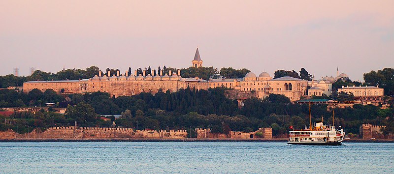
- Topkapi Palace. was the primary residence of the Ottoman Sultans for approximately 400 years (1465-1856) of their 624-year reign. As well as a royal residence, the palace was a setting for state occasions and royal entertainments. It is now a major tourist attraction and contains important holy relics of the Muslim world including the Prophet Muhammed's cloak and sword. The Topkapı Palace is among the monuments contained within the "Historic Areas of Istanbul", which became a UNESCO World Heritage Site in 1985. Following the end of the Ottoman Empire in 1921, the Topkapı Palace was transformed by a government decree dated April 3, 1924 into a museum of the imperial era. The palace complex has hundreds of rooms and chambers, but only the most important are accessible to the public today. The complex is guarded by officials of the ministry as well as armed guards of the Turkish military. The palace includes many fine examples of Ottoman architecture. It contains large collections of porcelain, robes, weapons, shields, armor, Ottoman miniatures,Islamic calligraphic manuscripts and murals, as well as a display of Ottoman treasures and jewelry.
- Hagia Sophia . A former Orthodox patriarchal basilica, later a mosque, and now a museum. Famous in particular for its massive dome, it is considered the epitome of Byzantine architecture and is said to have "changed the history of architecture. It was the largest cathedral in the world for nearly a thousand years, From the date of its dedication in 360 until 1453, it served as the Greek Cathedral of Constantinople, except between 1204 and 1261, when it was converted to a Roman Catholic cathedral under the Latin Patriarch of Constantinople of the Western Crusader established Latin Empire. The building was a mosque from 29 May 1453 until 1931, when it was secularized. It was opened as a museum on 1 February 1935
- The Sultan Ahmed Mosque. A historical mosque popularly known as the Blue Mosque for the blue tiles adorning the walls of its interior. It was built from 1609 to 1616, during the rule of Ahmed I. Like many other mosques, it also comprises a tomb of the founder, a madrasah and a hospice. While still used as a mosque, the Sultan Ahmed Mosque has also become a popular tourist attraction.
- The Grand Bizarre.The Grand Bazaar is one of the largest and oldest covered markets in the world, with more than 58 covered streets and over 4,000 shops as well as two mosques, two hamams, four fountains, and multiple restaurants and cafes. The sprawling complex consists of 12 major buildings and has 22 doors. which attract between 250,000 and half a million visitors daily.
- Bosphorus Bridge. The Bosphorus Bridge, also called the First Bosphorus Bridge is one of the two bridges spanning the Bosphorus strait and thus connecting Europe and Asia.The bridge is located between Ortaköy (on the European side) and Beylerbeyi (on the Asian side). It is a gravity anchored suspension bridge with steel pylons and inclined hangers. The Bosphorus Bridge had the 4th longest suspension bridge span in the world when it was completed in 1973, and the longest outside the United States. At present, it is the 17th longest suspension bridge span in the world.
 |
| Topkapi Palace |
 |
| The Sultan Ahmed Mosque |
Izmir

Izmir is a large metropolis in the western extremity of Anatolia in Turkey. Izmir metropolitan area extends along the outlying waters of the Gulf of İzmir and inland to the north across Gediz River's delta, to the east along an alluvial plain created by several small streams and to a slightly more rugged terrain in the south. The ancient city was known as Smyrna, and the city was generally referred to as Smyrna in English, until the Turkish Postal Services Law of 1930 made "Izmir" the internationally recognized name.
The city is one of the oldest settlements of the Mediterranean basin. The 2004 discovery of Yeşilova Höyük and the neighboring Yassıtepe, situated in the small delta of Meles River, now the plain of Bornova, reset the starting date of the city's past further back than was previously thought. The findings of the two seasons of excavations carried out in the Yeşilova Höyük indicate three levels, two of which are prehistoric. Level 2 bears traces of early to mid-Chalcolithic, and Level 3 of Neolithic settlements. These two levels would have been inhabited by the indigenous peoples of İzmir, very roughly, between 7th millennium BC to 4th millennium BC. With the seashore drawing away in time, the site was later used as a cemetery. Several graves containing artifacts dating, roughly, from 3000 BC, contemporary with the first city of Troy, were found.

İzmir's remarkable growth began in the late 16th century when cotton and other products of the region attracted French, English, Dutch and Venetian traders here. With the privileged trading conditions accorded to foreigners in 1620, İzmir set out on its way to become one of the foremost trade centers of the Empire. Foreign consulates moved in from Sakız (Chios) and were present in the city by the early 17th century (1619 for the French Consulate, 1621 for the British), serving as trade centers for their nations. Each consulate had its own quay and the ships under their flag would anchor there. The long campaign for the conquest of Crete (22 years between 1648–1669) also considerably enhanced İzmir's position within the Ottoman realm since the city served as a port of dispatch and supply for the troops.
The city faced a plague in 1676, an earthquake in 1688 and a great fire in 1743, but continued to grow. By the end of the 17th century, its population was estimated at around ninety thousand, the Turks forming the majority (about 60,000), while there were also 15,000 Greeks, 8,000 Armenians and 6 to 7,000 Jews, as well as a considerable segment composed of French, English, Dutch and Italian merchants. In the meantime, the Ottomans had allowed İzmir's inner bay dominated by the port castle to silt up progressively (the location of the present-day Kemeraltı bazaar zone) and the port castle ceased to be of use.

The Culture Park in the Alsancak district hosts the annual Izmir International fair, held every year in September. The rest of the year many other fairs and expos take place also. In addition to serving the commercial needs of the city the Culture Park provides a relaxing green area in the middle of the city for the residents to lay back, drink tea play backgammon and smoke a "hubbly bubbly pipe" (Nargile) or even exercise on the running track.
The city faced a plague in 1676, an earthquake in 1688 and a great fire in 1743, but continued to grow. By the end of the 17th century, its population was estimated at around ninety thousand, the Turks forming the majority (about 60,000), while there were also 15,000 Greeks, 8,000 Armenians and 6 to 7,000 Jews, as well as a considerable segment composed of French, English, Dutch and Italian merchants. In the meantime, the Ottomans had allowed İzmir's inner bay dominated by the port castle to silt up progressively (the location of the present-day Kemeraltı bazaar zone) and the port castle ceased to be of use.

Modern day Izmir is an interesting mixture of modern High rise buildings with wide tree lined boulevards. There are still many traditional houses and chateaus hidden away to discover though. Izmir enjoys a temperate climate with mild winters and warm summers, which is probably why the street life is so lively.
A walk on the Kordon reveals an endless line of bistros, bars, restaurants, coffee shops and tea houses all spilling onto the street. In many cases so close together it is often difficult to know exactly which place you are actually relaxing in.
Turkish cuisine which has inherited the Ottoman heritage could be described as a fusion and refinement of Turkic, Arabic, Greek, Armenian and Persian cuisines. Ottomans fused various culinary traditions of their realm with influences from Middle Eastern cuisines, along with traditional Turkic elements from Central Asia such as yogurt. The Ottoman Empire indeed created a vast array of technical specialities. It can be observed that various regions of the Ottoman Empire contain bits and pieces of the vast Ottoman dishes.
 |
| Kadifekale |
İzmir's cuisine has largely been affected by its multicultural history, hence the large variety of food originating from the Aegean, Mediterranean and Anatolian regions. Another factor is the large area of land surrounding the region which grows a rich selection of vegetables. Some of the common dishes found here are tarhana soup (made from dried yoghurt and tomatoes), İzmir köfte, keşkek (boiled wheat with meat), zerde (sweetened rice with saffron) and mücver (made from zucchini and eggs). Historically, as a result of the influx of Greek refugees from İzmir (as well as from other parts of Asia Minor and Istanbul) to mainland Greece after 1922, the cuisine of İzmir has had an enormous impact on Greek cuisine, exporting many sophisticated spices and foods.
The Culture Park in the Alsancak district hosts the annual Izmir International fair, held every year in September. The rest of the year many other fairs and expos take place also. In addition to serving the commercial needs of the city the Culture Park provides a relaxing green area in the middle of the city for the residents to lay back, drink tea play backgammon and smoke a "hubbly bubbly pipe" (Nargile) or even exercise on the running track.
 |
| Kemeralti |
Izmir’s Top 5:
- İzmir Clock Tower is located at the Konak Square in Konak district of İzmir. The clock tower was designed by the Levantine French architect Raymond Charles Père and built in 1901 to commemorate the 25th anniversary of Abdülhamid II's (reigned 1876–1909) accession to the throne. The clock itself was a gift of German Emperor Wilhelm II (reigned 1888–1918). It is decorated in an elaborate Ottoman architecture. The tower, at a height of 25 m (82 ft), features four fountains, which are placed around the base in a circular pattern, and the columns are inspired by North African themes. The clock tower was depicted on the reverse of the Turkish 500 lira banknotes of 1983-1989
- Kemeralti. A visit to Izmir can not be complete without spending a few hours wandering round the Market Area of Kemeralti. This is a bustling bazaar where literally anything can be purchased. It is a confusing warren of small allies, dead ends, connecting squares, shopping centers, offices, workshops, cinemas, Mosques and just about anything else you can think of, there is even a renovated Karavan Sarai hidden in there. You are pretty much guaranteed to lose your way, but don't panic you will find your way out eventually.
- Kadifekale (literally "the velvet castle" in Turkish) is the name of the hill located within the urban zone of İzmir, as well as being the name of the ancient castle on top of the same hill. Both the hill and the castle were named Pagos (Pagus under the Roman Empire) in pre-Turkish times. The summit where the castle is found is located at a distance of about 2 km from the shoreline and commands a general view of a large part of the city of İzmir, as well as of the Gulf of İzmir. Administratively, the hill area covers six quarters constituted by slums in their large part, one named Kadifekale like the hill, and others Alireis, Altay, İmariye, Kosova and Yenimahalle. In 2007, the metropolitan municipality of İzmir started renovation and restoration works in Kadifekale.
- Agora Open Air Museum (Old Smyrna) The ancient city is located at two sites within modern İzmir. The first site, probably founded indigenously, rose to prominence during the Archaic Period as one of the principal ancient Greek settlements in western Anatolia. The second, whose foundation is associated with Alexander the Great, reached metropolitan proportions during the period of the Roman Empire. Most of the present-day remains date from the Roman era, the majority from after a 2nd century AD earthquake. In practical terms, a distinction is often made between Old Smyrna, the initial settlement founded around the 11th century BC, first as an Aeolian settlement, and later taken over and developed during the Archaic Period by the Ionians, and Smyrna proper, the new city moved into from the older one as of the 4th century BC and whose foundation was inspired, and perhaps also initiated, by Alexander the Great.
- The İnciraltı Sea Museum is a naval museum in the İnciraltı neighborhood of Izmir's Balçova district. Located near the İnciraltı Ozdilek Shopping Center, it was opened on July 1, 2007. Main attractions of the museum are two decommissioned naval vessels of the Turkish Navy, the submarine TCG Pirireis (S 343) (the former USS Tang (SS-563)) and the frigate TCG Ege (F 256)(the former USS Ainsworth (FF-1090)). There are also other exhibits at the museum.

 |
| Agora |
References: http://www.izmir.com/
No comments:
Post a Comment