Aarhus

Aarhus or Århus is the second-largest city in Denmark. The principal port of Denmark, Aarhus is on the east side of the peninsula of Jutland in the geographical centre of Denmark. The city claims the unofficial title "Capital of Jutland".
The bishopric of Aarhus dates back to at least 951, and archaeological findings date back some 1,300 years to Viking times. The city itself is presumably older than 770 AD, making Aarhus the oldest big city in Scandinavia. The favorable central position of the city within Denmark afforded it trade from Germany, the Baltic countries, the greater peninsula of Jutland and the communities on the many smaller islands in its vicinity, which meant that trade always had a great significance to the town – a significance which is still true today.

The oldest archaeological findings in Aarhus are glass pearls, which date to the end of the 7th century. Half buried longhouses, used both as homes and workshops for the Vikings have also been found. In the houses and the adjoining archaeological layers, combs, jewelry and basic multi-purpose tools have been found that indicate the settlement is from approximately year 900. Digs in the spring of 2005 revealed a so-called city-ditch from the year 850 which might have marked the trade centre upon which the city is built.
The finding of six runestones in and around Aarhus indicates the city had some significance around year 1000 as only wealthy nobles traditionally used them. The center of Aarhus was once a pagan burial site until Aarhus' first church, Holy Trinity Church, a timber structure, was built upon it during the reign of Frode, King of Jutland, around 900.

In spite of these and other misfortunes, such as plague and city-wide fires, Aarhus was still quite a significant city in Denmark due to its favourable geographical position which was of significant importance for trading. Trade came mainly from the inland of Jutland but also from Norway, Lübeck, Amsterdam, England, France and Spain. In the middle of the 18th century the trade fleet consisted of approximately 100 ships.
There are hundreds of restaurants in Aarhus, reaching from cheap kebab joints, to high-class dining. Aarhus is generally known as one of the best places to eat in Denmark, probably due to the strong competition. However, the best places are not necessarily located on the most prominent addresses, so a bit of browsing is recommended. You could also try Åen - walk down "the river" in the city center, there are lots of restaurants and cafes with high standard.
In the 19th century, the city gained more independence from the dominance of Copenhagen and Hamburg. While it had been the third largest city in Jutland during the early 19th century, its population surpassed Randers in 1840 and in 1850, Aalborg, thus becoming the largest city in Jutland and the second largest in Denmark.
The city's material prosperity continued to increase as the harbour expanded and the railway network grew. Culturally, it marketed itself as the "Capital of Jutland" and expanded many of its cultural institutions like the national library, universities, the Aarhus Theatre and hospitals.
The city's material prosperity continued to increase as the harbour expanded and the railway network grew. Culturally, it marketed itself as the "Capital of Jutland" and expanded many of its cultural institutions like the national library, universities, the Aarhus Theatre and hospitals.

The locals regularly frequent the many cafés when going out for a meal. Besides being the best option for breakfast, brunch and lunch, most cafés serve excellent home made burgers, salads, sandwiches, soups and snacks at reasonable prices.
Aarhus's large student population fuels a lively nightlife. There is a robust nightlife for those who are looking for a night on the town. Aarhus can deliver everything from big mainstream clubs to small alternative hangouts playing niche music.
Prices for food and drink are higher than in other parts of Europe, especially near the river (Å in Danish). The favorite local beers are Tuborg, Carlsberg and Ceres (which is no longer brewed locally).

Prices for food and drink are higher than in other parts of Europe, especially near the river (Å in Danish). The favorite local beers are Tuborg, Carlsberg and Ceres (which is no longer brewed locally).

Aarhus’ Top 5:
- Aarhus Cathedral is the main religious edifice of Aarhus. The cathedral is dedicated to the patron saint of sailors, St. Clemens, and located at the address Domkirkepladsen 2, 8000 Århus C, Denmark, on the port-side of the central market of the town, Store Torv (lit. Danish: Large Square). The church is the longest in Denmark it is 93 m long and is also the tallest church in Denmark with 96 m, with seating for around 1200 people, and its building started at the end of the 12th century. The construction of Aarhus Cathedral began in the decade after year 1190, by Bishop Peder Vognsen of the powerful Hvide family from Zealand. Bishop Vognsen built the cathedral around St. Clement's church because local people venerated St. Niels, and Vognsen wanted to harness that devotion for his cathedral. Vognsen also established the cathedral school before the cathedral was completed. The church was finished in 1300 in typical Romanesque style with half-rounded arches supporting a flat timber ceiling. The second St. Clements was built of large red bricks, a new building material that became popular all over Scandinavia and northern Germany for ecclesiastical and public buildings. Four chapels were built into the north transept. The episcopal chair was moved from Our Lady Church to St. Clements. However, in 1330, the cathedral and much of the town burned down, and the church was abandoned until 1449. By then the Gothic style of architecture had reached Denmark, and the cathedral was enlarged in stages until it reached its present size in year 1500.
- The ARoS Aarhus Kunstmuseum is one of the largest art museums in northern Europe, 10 storeys tall with a total of 17,000 m². The museum opened on 8 April 2004 after a construction process that started with Danish architects schmidt hammer lassen winning the design competition in 1997. ARoS features a shop, café and restaurant. The architectural vision of the museum was completed in 2011 with the addition of the circular skywalk "Your rainbow panorama" by Ólafur Elíasson. The museum is divided into three different permanent collections: The Danish "Golden Age" 1770–1900, Danish Modernism 1900–1960 and Contemporary Art.
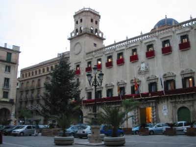
- Aarhus City Hall was inaugurated 2 June 1941, and it was drawn by architects Arne Jacobsen and Erik Møller. The decision to build a city hall was taken during a city hall meeting in 1937. As one of just a few Danish city halls it was marked for preservation in March 1994 because of its unique architecture. On the first proposal the plans did not include a tower but due to massive public pressure it was later added to the drawings.
The city hall has a total area of 19,380 m² including the basement. The tower is 60 m tall and the tower clock face has a diameter of 7 m. The building is made of concrete plated with 6,000 m² of marble from Porsgrunn in Norway. In January 2006 the city hall was included in the Danish Culture Kanon under architecture. - The Old Town in Aarhus, is an open-air town museum consisting of 75 historical buildings collected from 20 townships in all parts of the country. In 1914 the museum opened as the world's first open-air museum of its kind, concentrating on town culture rather than village culture, and to this day it remains one of just a few top rated Danish museums outside Copenhagen serving some 3.5 million visitors pr. year. The museum buildings are organized into a small town of chiefly half-timbered structures originally erected between 1550 and the late 19th century in various parts of the country and later moved to Aarhus during the 20th century. In all there are some 27 rooms, chambers or kitchens, 34 workshops, 10 groceries or shops, 5 historical gardens, a post office, a customs office, a school and a theatre.
- The Aarhus Theatre is the largest provincial theatre in Denmark. The present theatre house constructed in the late 19th century as a replacement for the old theatre, nicknamed "Svedekassen". Since Aarhus had grown to be Jutland's biggest city during the 19th century, the old theatre had become too small for the public. The new building was designed by the Danish architect Hack Kampmann (1856–1920), and the construction began on 12 August 1898. Only two years later the Theatre was completed, and it was inaugurated on 15 September 1900. The style of the building is Art Nouveau, with the national romantic emphasis on natural materials, and the interior was completed by artists Hansen-Reistrup and Hans Tegner. In 2007, the Aarhus Theatre received an audio make-over.


Alicante

Alicante is a city in Spain, the capital of the province of Alicante and of the comarca of Alacantí, in the south of the Valencian Community. It is also a historic Mediterranean port.
The area around Alicante has been inhabited for over 7000 years, with the first tribes of hunter gatherers moving down gradually from Central Europe between 5000 and 3000 BC. Some of the earliest settlements were made on the slopes of Mount Benacantil. By 1000 BC Greek and Phoenician traders had begun to visit the eastern coast of Spain, establishing small trading ports and introducing the native Iberian tribes to the alphabet, iron and the pottery wheel. By the 3rd century BC, the rival armies of Carthage and Rome began to invade and fight for control of the Iberian Peninsula. The Carthaginian general Hamilcar Barca established the fortified settlement of Akra Leuka, meaning "White Mountain" or "White Point"), where Alicante stands today.

Although the Carthaginians conquered much of the land around Alicante, the Romans would eventually rule Hispania Tarraconensis for over 700 years. By the 5th century AD, Rome was in decline and the Roman predecessor town of Alicante, known as Lucentum (Latin), was more or less under the control of the Visigothic warlord Theudimer. However neither the Romans nor the Goths put up much resistance to the Arab conquest of Medina Laqant in the 8th century. The Moors ruled southern and eastern Spain until the 13th century reconquista (reconquest). Alicante was finally taken in 1246 by the Castilian king Alfonso X, but it passed soon and definitely to the Kingdom of Valencia in 1298 with King James II of Aragon. It gained the status of Royal Village (Vila Reial) with representation in the medieval Valencian Parliament.
After several decades of being the battlefield where the Kingdom of Castile and the Crown of Aragón clashed, Alicante became a major Mediterranean trading station exporting rice, wine, olive oil, oranges and wool. But between 1609 and 1614 King Felipe III expelled thousands of Moriscos who had remained in Valencia after the Reconquista, due to their cooperation with Barbary pirates who continually attacked coastal cities and caused much harm to trade. This act cost the region dearly; with so many skilled artisans and agricultural labourers gone, the feudal nobility found itself sliding into bankruptcy. Things got worse in the early 18th century; after the War of Spanish Succession, Alicante went into a long, slow decline, surviving through the 18th and 19th centuries by making shoes and growing agricultural produce such as oranges and almonds, and thanks to its fisheries. The end of the 19th century witnessed a sharp recovery of the local economy with increasing international trade and the growth of the city harbour leading to increased exports of several products (particularly during World War I when Spain was a neutral country).
During the early 20th century, Alicante was a minor capital that enjoyed the benefit of Spain's neutrality during World War I, and that provided new opportunities for the local industry and agriculture. The Rif War in the 1920s saw numerous alicantinos drafted to fight in the long and bloody campaigns in the former Spanish protectorate (Northern Morocco) against the Rif rebels. The political unrest of the late 1920s led to the victory of Republican candidates in local council elections throughout the country, and the abdication of King Alfonso XIII. The proclamation of the Second Spanish Republic was much celebrated in the city on 14 April 1931. The Spanish Civil War broke out on 17 July 1936. Alicante was the last city loyal to the Republican government to be occupied by dictator Franco's troops on 1 April 1939, and its harbour saw the last Republican government officials fleeing the country. Vicious air bombings were targeted on Alicante during the three years of civil conflict, most notably the bombing by the Italian Aviazione Legionaria of the Mercado de Abastos in 25 May 1938 in which more than 300 civilians perished.

When dictator Franco died in 1975, his successor Juan Carlos I played his part as the living symbol of the transition of Spain to a democratic constitutional monarchy. The governments of regional communities were given constitutional status as 'nationalities', and their governments were given more autonomy, including that of the Valencian region.
The port of Alicante has been reinventing itself since the industrial decline the city suffered in the 1980s (with most mercantile traffic lost to Valencia's harbour). In recent years, the Port Authority has established it as one of the most important ports in Spain for cruises, with 72 calls to port made by cruise ships in 2007 bringing some 80,000 passengers and 30,000 crew to the city each year. The moves to develop the port for more tourism have been welcomed by the city and its residents, but the latest plans to develop an industrial estate in the port have caused great controversy.
As with the rest of Spain food is a very important part of the local identity. In Alicante, breakfast is usually light, usually some sort of bread (e.g. toast) or piece of bakery. Traditionally, a hearty meal in the early afternoon is followed by a siesta as the heat builds. Many restaurants are then closed between 4-9pm. A light meal is taken once the sun goes down, often in the local taperia if you are a visitor. A lot of restaurants don't open before 9pm for dinner, so bear this in mind when planning your dinner schedule.

As elsewhere in the region, seafood and rice dominates, with paella in the frontline. In almost every restaurant, you will find a "menu of the day" or a similar special for €10, a three- or four-course meal with or without a drink. This is an excellent way to economise if you want to splash out later. Go around Calle Castaños (near the Theatre), Calle San Francisco and Calle Mayor (near Saint Nicholas Cathedral) for hubs of restaurants across the whole price range.
Alicante has its own regulatory wine council. Tinto Alicante and Moscatel Alicante are the most known varieties.
Nightlife is concentrated in Old Town, called El Barrio or El Casco Antiguo, with dozens of bars and clubs along the narrow streets. Another focal point is the eastern rim of the marina, called Puerto, in and around the casino, where things start and end later.
The "Barrio" is the center of nightlife in Alicante, with bars like Dos Gringos, Mulligans, Carpe Diem, and Swing; there is never a dull night in this small Spanish city. Drinks are cheap, and shots are sometimes free. Pregame of "Botellon" on the castel or on the beach, then head over to the Barrio at around midnight. Then head over to swing or the puerto at 4am. A typical night should end at around 7 or 8am. (Note: "El botellon," literally, "the large bottle," is a custom among young people in Spain, in which they buy 2-litre bottles of soft drinks and mix into them hard liquor, and then stand or sit around drinking in parking lots and other public places. This is to avoid the high cost of drinks in some bars and clubs.)
There are market stalls along the Explanada d'Espanya selling beads, clothes, flags etc.
If you want to see how the locals shop, head into town down the Rambla de Méndez Núnez then turn West on the Avenue de Alfonso El Sabio, and you'll find the city's main market, the Mercado Central de Alicante(38°20'52.5"N 0°29'9.6"W). It is open until about 14:30 or so most days, the two levels sell all the fresh meat, seafood, cheeses, fruit and vegetables anyone could need. If you exit the market through the back, you'll find the flower sellers in a small outdoor square.
If you want to see how the locals shop, head into town down the Rambla de Méndez Núnez then turn West on the Avenue de Alfonso El Sabio, and you'll find the city's main market, the Mercado Central de Alicante(38°20'52.5"N 0°29'9.6"W). It is open until about 14:30 or so most days, the two levels sell all the fresh meat, seafood, cheeses, fruit and vegetables anyone could need. If you exit the market through the back, you'll find the flower sellers in a small outdoor square.

Alicante’s Top 5:
- The Co-cathedral of Saint Nicholas of Bari is a Roman Catholic co-cathedral. The church, part of the Diocese of Orihuela-Alicante is dedicated to Saint Nicholas and was elevated to the title of cathedral on 9 March 1959 by Pope John XXIII. This church was built between 1613 and 1662. It was designed between 1610 and 1615 by Agustín Bernardino, a student of Juan de Herrera, and was constructed over an ancient mosque. The cathedral has a Latin cross plan, though the transepts are quite short. flanking the nave are six interconnecting side chapels and an ambulatory around the apse. A blue dome rises 45 meters above the crossing. The chapel of Holy Communion, configured as a small Greek cross-planned temple, is considered to be one of the most beautiful examples of the Spanish Baroque. The external appearance of the cathedral is quite sober. The main facade located on the east side is of the Doric order, and the one built on the south side is of Ionic order.
- Tabarca, also known in Valencian as Nova Tabarca and Illa Plana, is an islet located in the Mediterranean Sea. Tabarca is the smallest permanently inhabited islet in Spain and it is currently known for its marine reserve. Despite being much more socially and economically related to the fishing port of Santa Pola, the tiny island of Tabarca is a part of the city of Alicante. Administratively, it is managed as a rural district of Alicante, jointly with el Palmeral, Aiguamarga and Urbanova. Tabarca was the last Spanish Mediterranean location where the critically endangered Mediterranean monk seal successfully bred before it became extinct in this part of its range in the 1960s. This proves the high quality of the waters around the island in terms of marine ecology. Therefore waters around Tabarca were declared a Marine reserve in 1986, the first of its kind in Spain.
- The Basilica of Santa Maria is the oldest active church in Alicante. It was built in Gothic style between the 14th and 16th centuries over the remains of a mosque.
The basilica is composed from a single nave with six side chapels located between the buttresses. In 2007, by request of the city of Alicante to the Holy See, the church was promoted to the rank of basilica. - The Archaeological Museum of Alicante is an archaeological museum in Alicante. The museum won the European Museum of the Year Award in 2004, a few years after significant expansion and reallocation to renovated buildings of the antique hospital of San Juan de Dios. The museum houses eight galleries that use multimedia to allow visitors to interact with the lives of past residents of the region.
- Santa Bárbara Castle is a fortification which stands on the Mount Benacantil (166 m).
Bronze Age, Iberian, and Roman artifacts have been found on the slopes of the mountain, but the origins of the castle date to the 9th century at the time of Muslim control of the Iberian Peninsula. The Arab medieval geographer Al-Idrisi calls this mountain Banu-lQatil, and the toponym may derive from the words pinna (Arabic for "peak") and laqanti, adjectival form of Laqant, the Arabic name for Alicante. On 4 December 1248, the castle was captured by Castilian forces led by Alfonso of Castile, later King Alfonso X. It was named after Saint Barbara, on whose feast day the castle was captured. It was conquered by the Aragonese in 1296 during the reign of James II of Aragon, who ordered its reconstruction. Peter IV of Aragon, Charles I of Spain and Philip II of Spain would oversee further reconstructions. From the 18th century the military role of the castle has declined and it was used sometimes as a prison. The castle remained abandoned until 1963, when it was opened to the public. Lifts have been installed inside the mountain.


Amiens

Amiens is a city and commune in northern France, 120 km (75 mi) north of Paris and 100 km (62 mi) south-west of Lille. It is the capital of the Somme department in Picardy.
The first known settlement is Samarobriva ("Somme bridge"), the central settlement of the Ambiani, one of the principal tribes of Gaul, who were issuing coinage, probably from Amiens, in the 1st century BC. The Ambiani derive their name from the Gaulish word ambe meaning river – a reference to the Somme that flows through Amiens. The town was given the name Ambianum by the Romans, meaning settlement of the Ambiani people. By tradition, it was at the gates of Amiens that Saint Martin of Tours, at the time still a Roman soldier, shared his cloak with a naked beggar. The prosperity of the city made it a target for barbarian tribes such as the Alans, the Burgundians or the Vandals, who attacked the city several times.
 During the 5th century, Chlodio rose to power among the Franks, and Merovech was elected in Amiens by his comrades in arms. Saint Honorius (Honoré) (d. 600 AD) became the seventh bishop of the city. Normans sacked the city 859 and again in 882. During the second sacking, the city's cathedral was burned. During the early part of the 10th century, Count Herbert de Vermandois united the regions of Amiens, Vexin, Laon, and Reims. In 1095, the people of Amiens began to form a rough municipal organization. In 1113 the city was recognized by the King of France; the city was joined to the Crown of France in 1185.
In 1264, Amiens was chosen as the seat of arbitrations when King Louis IX of France settled the conflict between King Henry III of England and his rebellious barons, led by Simon de Montfort. The arbitrations led to Louis deciding on the Mise of Amiens – a one-sided settlement in favor of Henry. This decision almost immediately led to the outbreak of the Barons' War.
In 1435 the city was among the possessions granted to Philip the Good of Burgundy by the Congress of Arras. It was re-acquired again by King Louis XI in 1477 after the death of Charles the Bold. In 1597, Spanish soldiers disguised as peasants entered the city and mounted a surprise attack. After the six month Siege of Amiens, the forces of Henry IV regained control of the city and put an end to its autonomous rule.
 During the 18th and 19th century, the textile tradition of Amiens became famous for its velours. The Cosserat family rose to prominence as one of the wealthiest of Amiens' textile manufacturing families. In 1789 the provinces of France were dismantled and the territory was organised into departments. Much of Picardy became the newly-created department of Somme, with Amiens as the departmental capital.

In 1264, Amiens was chosen as the seat of arbitrations when King Louis IX of France settled the conflict between King Henry III of England and his rebellious barons, led by Simon de Montfort. The arbitrations led to Louis deciding on the Mise of Amiens – a one-sided settlement in favor of Henry. This decision almost immediately led to the outbreak of the Barons' War.
In 1435 the city was among the possessions granted to Philip the Good of Burgundy by the Congress of Arras. It was re-acquired again by King Louis XI in 1477 after the death of Charles the Bold. In 1597, Spanish soldiers disguised as peasants entered the city and mounted a surprise attack. After the six month Siege of Amiens, the forces of Henry IV regained control of the city and put an end to its autonomous rule.

In November 1801, British and French delegates began discussing terms of peace at the Amiens Congress. On 25 March 1802, the United Kingdom of Great Britain and Ireland and the First French Republic signed the Treaty of Amiens, putting an end to the Second Coalition against France.
During the 19th century, Amiens began to feel the effects of the industrial revolution. The city walls were demolished, opening up space for large boulevards around the town centre. The Henriville neighborhood in the south of the city was developed around this time. In 1848, the first railway arrived in Amiens, linking the city to Boulogne-sur-Mer. After this time, the city began to grow beyond the river and into the surrounding hills. During the 1870 Franco-Prussian War, Somme was invaded by Prussian forces and Amiens was occupied.
Early science fiction author Jules Verne took up residence in Amiens in 1871, having met his wife there at a wedding in 1856. He was later elected city councilman in 1888. In 1889, Jules Verne presided over the opening of the Amiens circus, including a courthouse, a police station and a museum dedicated to the history of Picardy.
Beginning in 1905, Victor Commont, called "the founding father of modern Prehistoric science," performed important archaeological work in the Picardy area.
During the 19th century, Amiens began to feel the effects of the industrial revolution. The city walls were demolished, opening up space for large boulevards around the town centre. The Henriville neighborhood in the south of the city was developed around this time. In 1848, the first railway arrived in Amiens, linking the city to Boulogne-sur-Mer. After this time, the city began to grow beyond the river and into the surrounding hills. During the 1870 Franco-Prussian War, Somme was invaded by Prussian forces and Amiens was occupied.
 |
| Maison de Jules Verne |
Beginning in 1905, Victor Commont, called "the founding father of modern Prehistoric science," performed important archaeological work in the Picardy area.
At the start of the First World War, in August 1914, Amiens had been the Advance Base for the British Expeditionary Force. It was captured by the German Army on 31 August 1914, but recaptured by the French on 28 September. The proximity of Amiens to the Western Front and its importance as a rail hub, made it a vital British logistic centre, especially during the Battle of the Somme in 1916.
Amiens was one of the key objectives of the German Spring Offensive which was launched on 27 March 1918. The German 2nd Army pushed back the British 5th Army, who fought a series of defensive actions. Eventually, on 4 April, the Germans succeeded in capturing Villers-Bretonneux which overlooked Amiens, only for it to be retaken by an Australian counterattack that night. During the fighting, Amiens was bombarded by German artillery and aircraft; more than 2,000 buildings were destroyed. On 8 August 1918, a successful Allied counter stroke, the Battle of Amiens, was the opening phase of the Hundred Days Offensive, which led directly to the Armistice with Germany that ended the war.
Amiens was one of the key objectives of the German Spring Offensive which was launched on 27 March 1918. The German 2nd Army pushed back the British 5th Army, who fought a series of defensive actions. Eventually, on 4 April, the Germans succeeded in capturing Villers-Bretonneux which overlooked Amiens, only for it to be retaken by an Australian counterattack that night. During the fighting, Amiens was bombarded by German artillery and aircraft; more than 2,000 buildings were destroyed. On 8 August 1918, a successful Allied counter stroke, the Battle of Amiens, was the opening phase of the Hundred Days Offensive, which led directly to the Armistice with Germany that ended the war.
During the Battle of France in World War II, Amiens was captured by the German 1st Panzer Division on 20 May 1940, following two days of heavy air raids. It had been defended by a British Territorial Army battalion, the 7th Royal Sussex Regiment, who were almost all either killed or made prisoner. Of 581 men with the battalion, 70 survived to be captured and only three escaped back to the battalion HQ.
 On 18 February 1944, British aircraft bombed the prison in Amiens as part of Operation Jericho. The raid was intended to aid the escape of members of the French Resistance and political prisoners being held there. In all, 258 prisoners escaped.
Prior to the Normandy landings, Allied aircraft concentrated on disabling communications in occupied France, and the railway junction at Longueau to the south east of Amiens was attacked by 200 Royal Air Force bombers on the night of the 12 and 13 June. There was much damage in the town itself. Amiens was liberated on 31 August 1944 by the 11th Armoured Division, part of 30th Corps commanded by Lieutenant-General Horrocks.

Prior to the Normandy landings, Allied aircraft concentrated on disabling communications in occupied France, and the railway junction at Longueau to the south east of Amiens was attacked by 200 Royal Air Force bombers on the night of the 12 and 13 June. There was much damage in the town itself. Amiens was liberated on 31 August 1944 by the 11th Armoured Division, part of 30th Corps commanded by Lieutenant-General Horrocks.
In the post war years, the city was rebuilt according to Pierre Dufau's plans, with a focus on widening the streets to ease traffic congestion. These newer structures were primarily built of brick, concrete and white stone with slate roofs. The architect Auguste Perret designed the Gare d'Amiens train station and nearby Tour Perret.
On 2 June 1960, the new region of Picardy was formed from the departments of Aisne, Oise and Somme. In May 1968, students in Amiens joined in a large-scale strike that began in Paris. Factory and the railway workers in the city joined them a few days later. Amiens was paralyzed by fighting between conservatives and leftist groups. After President Charles de Gaulle's radio address on 31 May, his supporters demonstrated in the streets. The following October, the University of Amiens (Université d'Amiens) was founded on a campus in the southwestern suburbs of the city.
 The city suffered the loss of many jobs as manufacturing plants in the region closed during the late 1970s and 1980s. Despite the hardships, the city made an effort to renovate the degraded area of St-Leu during this time.
The 1990s saw a great period of rebirth in the city. The St-Leu renovations were completed, and parts of the University were moved to the city center. The Vallée des Vignes neighborhood was developed in the south of the city, and large parts of the city center were converted to pedestrian areas. The Gare du Nord was renovated with a controversial new glass roof. The Tour Perret was renovated as well and a new cinema complex was built. The area around the train station began a reorganization.
On 2 June 1960, the new region of Picardy was formed from the departments of Aisne, Oise and Somme. In May 1968, students in Amiens joined in a large-scale strike that began in Paris. Factory and the railway workers in the city joined them a few days later. Amiens was paralyzed by fighting between conservatives and leftist groups. After President Charles de Gaulle's radio address on 31 May, his supporters demonstrated in the streets. The following October, the University of Amiens (Université d'Amiens) was founded on a campus in the southwestern suburbs of the city.

The 1990s saw a great period of rebirth in the city. The St-Leu renovations were completed, and parts of the University were moved to the city center. The Vallée des Vignes neighborhood was developed in the south of the city, and large parts of the city center were converted to pedestrian areas. The Gare du Nord was renovated with a controversial new glass roof. The Tour Perret was renovated as well and a new cinema complex was built. The area around the train station began a reorganization.

Amiens’ Top 5:
- The Cathedral of Our Lady of Amiens, or simply Amiens Cathedral, is a Roman Catholic cathedral and seat of the Bishop of Amiens. It is situated on a slight ridge overlooking the River Somme. The cathedral is the tallest complete cathedral in France, its stone-vaulted nave reaching a height of 42.30 metres (138.8 ft) (surpassed only by the incomplete Beauvais Cathedral). It also has the greatest interior volume of any French cathedral, estimated at 200,000 cubic metres (260,000 cu yd). The cathedral was built between 1220 and c.1270 and has been listed as a UNESCO World Heritage Site since 1981. Although it has lost most of its original stained glass, Amiens Cathedral is renowned for the quality and quantity of early 13th century Gothic sculpture in the main west facade and the south transept portal, and a large quantity of polychrome sculpture from later periods inside the building.
- The Musée de Picardie is the main museum of Amiens and Picardy, at 48, rue de la République. Its collections stretch from prehistory to the 19th century and form one of the largest regional museums in France. Its building was purpose-built for a regional museum (one of France's first such buildings) between 1855 and 1867. The architects were Henri Parent and Arthur-Stanislas Diet. It was built thanks to militant action by the Société des Antiquaires de Picardie, keen to give the city somewhere to house the collections the society had gathered over decades.
- The Municipal Circus, also known as the "Cirque Jules Verne", is one of the few remaining permanent circuses (in French: "Cirque en dur") in the world, one of seven in France and is still in use today. Originally built from timber it is now a stone structure.
- Jules Verne's House. After major renovation works, the "House with the Tower" in Amiens, where Jules Verne lived from 1882 to 1900, once again offers visitors a space where the imaginary world and the daily life of the famous writer mix. This luxury 19th century mansion house witnessed the success of the writer, who wrote most of his "Extraordinary Voyages" there. Both imposing and modest, on four levels and through over 700 objects in the Amiens Metropole collection, the house reveals the personality, sources of inspiration and memories of Jules Verne. From the conservatory to the attic, relive the adventures of his heroes: Michel Strogoff, Phileas Fogg, Captain Nemo, etc.
- Citadelle de Doullens. The only currently standing Renaissance citadel, this is a masterpiece of military architecture from the end of the Middle Ages. It was especially created to be used by the growing artillery and served as a model for future Vauban citadels. It has conserved its remarkable sandstone ramparts, its circular galleries and its shooting chambers.


Amsterdam

© Pictures of Amsterdam courtesy of Amsterdam.info
Although the seat of Netherlands government is in The Hague, Amsterdam is the nominal capital. It is also the country's largest city, with a population of more than 750,000, and the most visited, with over 3,5 million foreign visitors a year.
Cultural, hedonistic, historic and relaxed; Amsterdam is many things in one. But it is almost impossible to deny that this is a fantastic city. With miles of UNESCO listed canals cutting through charming cafe lined walks and past medieval buildings, the city is a feast for the eyes as well as the senses. Sure there are loads of coffee shops and bars, but if you spend your time partying too hard you’re missing out on the many delights like Anne Frank’s house, Artis Royal Zoo and windmills!
 And as the city is so close to the UK, there are numerous flights and ferry services, so is a perfect place for a short city break away.
Visitors can gaze at the many works of post-impressionist painter Van Gogh at a museum dedicated to him, explore cultural history at the Rijksmuseum and get a tour of a diamond factory, all in the Museum Quarter. There are also abundant modern art galleries like Cobra Museum of Modern Art which documents the Cobra Movement - a 20th century break away from abstract ideas with a focus on spontaneity and colour. Or if you’d prefer something more obscure, there are museums specialising in everything from houseboats and cat paintings to spectacles!
From glass covered modern architecture to 14th century relics, Amsterdam is a city that respects its ancient foundations while pushing the boundaries into the new. Starting off from the grand and impressive 19th century Central Station, you’ll want to take a picture of the Bike Flat, a huge, sloping three story parking deck that can hold 2500 bicycles! From there head towards the lively Dam Square which is flanked by the incredible Royal Palace and De Nieuwe Kerk. Then continue until you get to Begijnhof – a collection of gothic almshouses once home to the Beguines, a religious group of women famous for their chastity.
In the eastern docklands is Scheepstimmermanstraat, a residential street where people have been allowed to employ their own architect to build a dream house. One of them has been built around a tree! The city is also home to the world’s narrowest house – at one metre wide – a modern Buddhist temple with relics imported from China and an Old Church erected in 1306... And let’s not forget the many historic windmills. Could there be anything more Dutch?
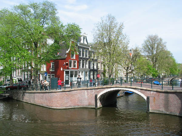
With more than 100km of canals and bridges, Amsterdam has been called the Venice of the North, but what most people don’t realise is that the city’s waterways outnumber the Italian’s by far! Canals are also the most defining thing about Amsterdam and have been immortalised in songs, poems and stories.

Do as the Dutch do and rent a bike to cycle beside them, sip coffee from the many cafes like Villa Zeezicht and Cafe van Zuylen or dine in the floating restaurant Amstelhaven. Or of course you can just sit by them and enjoy the passing city life...
There are also ten city beaches in the metropolis like the sandy Strand West where you can lounge in a hammock. For a unique experience, head to the high rise BovenNEMO atop the Science Centre, complete with olive trees, ice-cream and sand all complemented with panoramic views of the city!
With a penchant and international reputation for hedonism, it’s no surprise that Amsterdam has a thumping nightlife scene. There is a huge smattering of jazz clubs, brown cafes and chic restaurants. Along with Britain, Germany, Belgium and the Czech Republic, the Netherlands is one of the great traditional brewing nations of the world. Dutch beer is fruity and strong, and there is no better place to try it than in a brown cafe. These authentic pubs are named after their dark, wooden interiors and are a great way to experience historic Amsterdam. There are many catering to all types of clientele but most are very relaxed. In ‘t Aepjen is one of the oldest in the city and is a good place to try jenever, a Dutch spirit similar to gin.
Amsterdam is also known as one of the world’s premier jazz cities and is home to a concert hall dedicated to the music – the Bimhuis. Otherwise there are plenty of joints like Cafe Alto which is a brown cafe and gig venue merged into one!
The Dutch capital will not disappoint. In summer the weather is pleasant and tranquil, while in winter pubs and cafes are perfect for warming those cold hands with a steaming cup of coffee or warm beer. So get out here for some cultural treat

Visitors can gaze at the many works of post-impressionist painter Van Gogh at a museum dedicated to him, explore cultural history at the Rijksmuseum and get a tour of a diamond factory, all in the Museum Quarter. There are also abundant modern art galleries like Cobra Museum of Modern Art which documents the Cobra Movement - a 20th century break away from abstract ideas with a focus on spontaneity and colour. Or if you’d prefer something more obscure, there are museums specialising in everything from houseboats and cat paintings to spectacles!
From glass covered modern architecture to 14th century relics, Amsterdam is a city that respects its ancient foundations while pushing the boundaries into the new. Starting off from the grand and impressive 19th century Central Station, you’ll want to take a picture of the Bike Flat, a huge, sloping three story parking deck that can hold 2500 bicycles! From there head towards the lively Dam Square which is flanked by the incredible Royal Palace and De Nieuwe Kerk. Then continue until you get to Begijnhof – a collection of gothic almshouses once home to the Beguines, a religious group of women famous for their chastity.
In the eastern docklands is Scheepstimmermanstraat, a residential street where people have been allowed to employ their own architect to build a dream house. One of them has been built around a tree! The city is also home to the world’s narrowest house – at one metre wide – a modern Buddhist temple with relics imported from China and an Old Church erected in 1306... And let’s not forget the many historic windmills. Could there be anything more Dutch?
With more than 100km of canals and bridges, Amsterdam has been called the Venice of the North, but what most people don’t realise is that the city’s waterways outnumber the Italian’s by far! Canals are also the most defining thing about Amsterdam and have been immortalised in songs, poems and stories.
Do as the Dutch do and rent a bike to cycle beside them, sip coffee from the many cafes like Villa Zeezicht and Cafe van Zuylen or dine in the floating restaurant Amstelhaven. Or of course you can just sit by them and enjoy the passing city life...
There are also ten city beaches in the metropolis like the sandy Strand West where you can lounge in a hammock. For a unique experience, head to the high rise BovenNEMO atop the Science Centre, complete with olive trees, ice-cream and sand all complemented with panoramic views of the city!
With a penchant and international reputation for hedonism, it’s no surprise that Amsterdam has a thumping nightlife scene. There is a huge smattering of jazz clubs, brown cafes and chic restaurants. Along with Britain, Germany, Belgium and the Czech Republic, the Netherlands is one of the great traditional brewing nations of the world. Dutch beer is fruity and strong, and there is no better place to try it than in a brown cafe. These authentic pubs are named after their dark, wooden interiors and are a great way to experience historic Amsterdam. There are many catering to all types of clientele but most are very relaxed. In ‘t Aepjen is one of the oldest in the city and is a good place to try jenever, a Dutch spirit similar to gin.
Amsterdam is also known as one of the world’s premier jazz cities and is home to a concert hall dedicated to the music – the Bimhuis. Otherwise there are plenty of joints like Cafe Alto which is a brown cafe and gig venue merged into one!
The Dutch capital will not disappoint. In summer the weather is pleasant and tranquil, while in winter pubs and cafes are perfect for warming those cold hands with a steaming cup of coffee or warm beer. So get out here for some cultural treat
Amsterdam’s Top 5:
 |
- Anne Frank's House. Made famous by her sorrowful diary written during Nazi occupied Holland, Anne Frank hid for two years in the attic of a residential house on Prinesengracht 263. A visit to the house is a must, which has now been preserved as a museum with photos lining the walls and her original diary on display.
- Red Light District. Beer and party atmosphere, sex for sale, and limitless people-watching. The stores are full of hardcore videos, magazines and sex toys. The Red Light District is somewhat of a sexual amusement park and often not taken too seriously by the hordes of tourist who frequent it. The famous red window lights are striking against the quaint, old canal houses and even the fairy lights that line the bridges at night are coloured red. Although it is generally considered to be a very safe area, care should still be taken when walking through the quieter streets of the area. There is a strict “no photography” policy.
- Oude Kerk. This old church with little houses clinging to its sides, remains a calm heaven at the heart of the frenetic Red Light District. Its buildings, especially the Gothic-renaissance style octagonal bell tower, were used by sailors to get their bearings.
- Dam square. The Dam is the very centre and heart of Amsterdam, although there are arguably prettier sights in the city. As an historical site however, it is fascinating and worth taking the time to appreciate. The Dam has seen many historical dramas unfold over the years, and was for example, the reception area for Napoleon and his troops during the 1808 take-over of the city. The impressive history of the square is well documented in the Amsterdam Historical Museum. The Royal Palace (Koninklijk Paleis) which dominates the square, was originally used as the town hall and its classical facade and fine sculptures were intended to glorify the city of Amsterdam and its government. In contrast to its turbulent history, the square is now a peaceful place and is home to hundreds of pigeons and tourists resting their tired feet.
- Magere Brug. Of Amsterdam's 1280 or so bridges, the Magere Brug, or “ Skinny Bridge” is the most famous. It is a traditional double-leaf, Dutch draw-bridge connecting the banks of the river Amstel. Approximately every twenty minutes, the bridge opens to let boats through. The original bridge was built in 1670, but as the traffic on Amstel increased, a wider bridge was built to replace the narrow one.

Magere Brug

References:

© 2003-2011 Amsterdam guide - Tourist information, accommodation, hotels, apartments.
Amsterdam.info is not associated to any institutions subsidised by the government.
Ancona

Ancona is a city and a seaport in the Marches region, in central Italy. Ancona is the capital of the province of Ancona and of the region.
The city is located 280 km (170 mi) northeast of Rome, on the Adriatic Sea, between the slopes of the two extremities of the promontory of Monte Conero, Monte Astagno and Monte Guasco.
Ancona is one of the main ports on the Adriatic Sea, especially for passenger traffic, and is the main economic and demographic centre of the region.

Ancona was founded by Greek settlers from Syracuse about 387 BC, who gave it its name: Ancona is a very slightly modified transliteration of the Greek Αγκων, meaning "elbow"; the harbour to the east of the town was originally protected only by the promontory on the north, shaped like an elbow. Greek merchants established a Tyrian purple dye factory here. In Roman times it kept its own coinage with the punning device of the bent arm holding a palm branch, and the head of Aphrodite on the reverse, and continued the use of the Greek language.
When it became a Roman colony is doubtful. It was occupied as a naval station in the Illyrian War of 178 BC. Julius Caesar took possession of it immediately after crossing the Rubicon. Its harbour was of considerable importance in imperial times, as the nearest to Dalmatia, and was enlarged by Trajan, who constructed the north quay with his Syrian architect Apollodorus of Damascus. At the beginning of it stands the marble triumphal arch with a single archway, and without bas-reliefs, erected in his honour in 115 by the Senate and Roman people.

Ancona was successively attacked by the Goths, Lombards and Saracens between the Third and Fifth Centuries, but recovered its strength and importance. It was one of the cities of the Pentapolis of the Roman Exarchate of Ravenna in the Seventh and Eighth Centuries. After Charlesmagne's conquest of northern Italy, it became the capital of the Marca di Ancona, whence the name of the modern region. After 1000, Ancona became increasingly independent, eventually turning into an important maritime republic (together with Gaeta, Trani and Ragusa, it is one of those not appearing on the Italian naval flag), often clashing against the nearby power of Venice. An oligarchic republic, Ancona was ruled by six Elders, elected by the three terzieri into which the city was divided: S. Pietro, Porto and Capodimonte. It had a coin of its own, the agontano, and a series of laws known as Statuti del mare e del Terzenale and Statuti della Dogana. Ancona was usually allied with Ragusa and the Byzantine Empire. In 1137, 1167 and 1174 it was strong enough to push back the forces of the Holy Roman Empire. Anconitan ships took part in the Crusades, and their navigators included Cyriac of Ancona. In the struggle between the Popes and the Holy Roman Emperors that troubled Italy from the 12th century onwards, Ancona sided with the Guelphs.
Ancona, as well as Venice, became a very important destination for merchants from the Ottoman Empire during the 16th century. The Greeks formed the largest of the communities of foreign merchants. They were refugees from former Byzantine or Venetian territories that were occupied by the Ottomans in the late 15th and 16th c. The first Greek community was established in Ancona early in the 16th c. Natalucci, the 17th c. historian of the city, notes the existence of 200 Greek families in Ancona at the opening of the 16th c. Most of them came from northwestern Greece, i.e. the Ionian islands and Epirus. In 1514, Dimitri Caloiri of Ioannina obtained reduced custom duties for Greek merchants coming from the towns of Ioannina, Arta and Avlona in Epirus. In 1518 a Jewish merchant of Avlona succeeded in lowering the duties paid in Ancona for all “the Levantine merchants, subjects to the Turk”.

In 1531 the Confraternity of the Greeks (Confraternita dei Greci) was established which included Orthodox and Catholic Greeks. They secured the use of the Church of St. Anna dei Greci and were granted permission to hold services according to the Greek and the Latin rite. The church of St. Anna had existed since the 13th c., initially as “Santa Maria in Porta Cipriana”, on ruins of the ancient Greek walls of Ancona.
In 1534 a decision by Pope Paul III favoured the activity of merchants of all nationalities and religions from the Levant and allowed them to settle in Ancona with their families. A Venetian travelling through Ancona in 1535 recorded that the city was “full of merchants from every nation and mostly Greeks and Turks”. In the second half of the 16th c., the presence of Greek and other merchants from the Ottoman Empire declined after a series of restrictive measures taken by the Italian authorities and the pope.
Disputes between the Orthodox and Catholic Greeks of the community were frequent and persisted until 1797 when the city was occupied by France who closed all the religious confraternities and confiscated the archive of the Greek community. The church of St. Anna dei Greci was re-opened to services in 1822. In 1835, in the absence of a Greek community in Ancona, it passed to the Latin Church.

Differently from other cities of northern Italy, Ancona never became a seignory. The sole exception was the rule of the Malatesta, who took the city in 1348 taking advantage of the black death and of a fire that had destroyed many of its important buildings. The Malatesta were ousted in 1383. In 1532 it definitively lost its freedom and became part of the Papal States, under Pope Clement VII. Symbol of the papal authority was the massive Citadel. Together with Rome, and Avignon in southern France, Ancona was the sole city in the Papal States in which the Jews were allowed to stay after 1569, living in the ghetto built after 1555.
In 1733 Pope Clement XII extended the quay, and an inferior imitation of Trajan's arch was set up; he also erected a Lazaretto at the south end of the harbour, Luigi Vanvitelli being the architect-in-chief. The southern quay was built in 1880, and the harbour was protected by forts on the heights. From 1797 onwards, when the French took it, it frequently appears in history as an important fortress. Ancona entered in the Kingdom of Italy when Christophe Léon Louis Juchault de Lamoricière surrendered here on 29 September 1860, eleven days after his defeat at Castelfidardo.
During World War II, in July 1944, the city was taken by the Polish II Corps as part of an Allied operation to gain access to a seaport closer to the Gothic Line in order to shorten their lines of communication for the advance into northern Italy.

Ancona’s Top 5:
- The Cathedral of Ancona, dedicated to Judas Cyriacus, was consecrated at the beginning of the 11th century and completed in 1189. Some writers suppose that the original church was in the form of a basilica and belonged to the 7th century. An early restoration was completed in 1234. It is a fine Romanesque building in grey stone, built in the form of a Greek cross, and other elements of Byzantine art. It has a dodecagonal dome over the centre slightly altered by Margaritone d'Arezzo in 1270. The façade has a Gothic portal, ascribed to Giorgio da Como (1228), which was intended to have a lateral arch on each side. The interior, which has a crypt under each transept, in the main preserves its original character. It has ten columns which are attributed to the temple of Venus. The church was restored in the 1980s.
- The Arch of Trajan, 18 m high, erected in 114/115 as an entrance to the causeway atop the harbour wall in honour of the emperor who had made the harbour, is one of the finest Roman monuments in Le Marche. Most of its original bronze enrichments have disappeared. It stands on a high podium approached by a wide flight of steps. The archway, only 3 m wide, is flanked by pairs of fluted Corinthian columns on pedestals. An attic bears inscriptions. The format is that of the Arch of Titus in Rome, but made taller, so that the bronze figures surmounting it, of Trajan, his wife Plotina and sister Marciana, would figure as a landmark for ships approaching Rome's greatest Adriatic port.
- The Lazzaretto (Laemocomium or "Mole Vanvitelliana"), planned by architect Luigi Vanvitelli in 1732 is a pentagonal building covering more than 20,000 m², built to protect the military defensive authorities from the risk of contagious diseases eventually reaching the town with the ships. Later it was used also as a military hospital or as barracks; it is currently used for cultural exhibits.
- The National Archaeological Museum (Museo Archeologico Nazionale) is housed in the Palazzo Ferretti, built in the late Renaissance by Pellegrino Tibaldi; it preserves frescoes by Federico Zuccari. The Museum is divided into several sections:
Prehistoric section, with palaeolithic and neolithic artefacts, objects of the Copper Age and of the Bronze Age. protohistoric section, with the richest existing collection of the Picenian civilization; the section includes a remarkable collection of Greek ceramics
Greek-Hellenistic section, with coins, inscriptions, glassware and other objects from the necropolis of Ancona. Roman section, with a statue of Augustus, Pontifex Maximus, carved sarcophagi and two Roman beds with fine decorations in ivory. - The Loggia dei Mercanti is a historical palace in Ancona. The palace was begun in 1442 by architect Giovanni Pace, also known as Sodo, in an economically flourishing period for Ancona. It was built near the port, which was the trade point of the mercantile republic in medieval times, in order to provide a meeting point for the traders. The building was restored in 1558-1561 after a fire, under the direction of Pellegrino Tibaldi, who also frescoed the central hall. The current façade was designed by the Dalmatian architect Giorgio da Sebenico, who worked to it in 1451 to 1459. It is divided into four vertical sections, topped by a pinnacle. Each one has a statue, representing (from left), Hope, Fortitude, Justice and Charity. The two side sections have two stained glass, ogival windows. In the upper sectors are blind double mullioned windows and, in the centre, is an equestrian statue of the Roman emperor Trajan. The Loggia was damaged by the Allied bombings during World War II, and was restored in the late 20th century.

.JPG)
Angers

Angers is a city in western France, about 300 km (190 mi) southwest of Paris, and the chef-lieu of the Maine-et-Loire department. Angers was before the French Revolution the capital of the province of Anjou, and inhabitants of both the city and the province are called Angevins.
The first sign of human presence in Angers dates back to 400,000 BC. Vestiges from the Neolithic are more abundant and include numerous polished stone axes. Burials from 4,500/3,500 BC were also discovered in the actual castle grounds.

During the 5th century, the Andecavi, a Celtic people, settles north of the Loire. By the end of the Age of Iron, Angers is a relatively densely populated oppidum. The name Juliomagus, might it be more ancient, is not attested before the 3rd century AD. The Roman town consisted of many villas, baths and had an amphitheatre as well as a temple dedicated to Mithra.
Successive Germanic invasions in 275 and 276 forced the inhabitants to move on the highest point of their city and to build a wall around a small area of around 9 hectares.
Successive Germanic invasions in 275 and 276 forced the inhabitants to move on the highest point of their city and to build a wall around a small area of around 9 hectares.
Angers gets its first bishop in 372, during the election of Martin of Tours. The first abbey, Saint-Aubin, is built during the 7th century to house the sarcophagus of Saint Albinius. Saint-Serge abbey is founded by the Merovingian kings Clovis II and Theuderic III a century later. In 2008, ten sarcophagi form that period were discovered where Saint-Morille church once stood during the tramway construction.
From the 850s, Angers suffers from its situation on the border with Brittany and Normandy. In September 851, Charles the Bald and Erispoe, a Breton chief, meet in the town to sign the Treaty of Angers, which secures the Breton independence and fixes the borders of Brittany. However, the situation remains dangerous for Angers, and Charles the Bald creates in 853 a wide buffer zone around Brittany comprising parts of Anjou, Touraine, Maine and Sées, which is ruled by Robert the Strong, a great-grandfather of Hugh Capet.
From the 850s, Angers suffers from its situation on the border with Brittany and Normandy. In September 851, Charles the Bald and Erispoe, a Breton chief, meet in the town to sign the Treaty of Angers, which secures the Breton independence and fixes the borders of Brittany. However, the situation remains dangerous for Angers, and Charles the Bald creates in 853 a wide buffer zone around Brittany comprising parts of Anjou, Touraine, Maine and Sées, which is ruled by Robert the Strong, a great-grandfather of Hugh Capet.

In 870, the Viking chief Hastein seizes Angers where he settles, but quickly surrounds after a siege. He takes again control of the town in 873, before being ousted by the Carolingian Emperor.
Fulk I of Anjou, a Carolingian descendant, is, first, viscount of Angers (before 898 until 830) and of Tours (898-909), and count of Nantes (909-919). Around 929, he takes the title of count of Angers and founds the first Anjou dynasty.
During the 12th century, after internal divisions in Brittany, the county of Nantes is annexed by Anjou. Henry II Plantagenêt keeps it for more than 30 years. At the same time, he also rules the vast Angevin Empire, which stretched from the Pyrenees to Ireland. The castle of Angers is then the seat of the Court and the dynasty. The Empire disappeared in 1204-1205 when the King of France, Philip II, seized Normandy and Anjou.
During the 12th century, after internal divisions in Brittany, the county of Nantes is annexed by Anjou. Henry II Plantagenêt keeps it for more than 30 years. At the same time, he also rules the vast Angevin Empire, which stretched from the Pyrenees to Ireland. The castle of Angers is then the seat of the Court and the dynasty. The Empire disappeared in 1204-1205 when the King of France, Philip II, seized Normandy and Anjou.

Henceforth a part of the Kingdom of France, Angers becomes the "Clé du Royaume" (Key to the Kingdom) facing independent Brittany. In 1228, during Louis IX's minority, Blanche of Castile decides to fortify the city and to rebuild the castle. Later, during the 1350s and 1360s, the schools of Law, Medicine and Theology, renowned in the whole Europe, are organised in a university. In 1373, Louis I of Naples and Anjou orders the six tapestries illustrating the Apocalypse of St John known today as the Apocalypse Tapestry.
King René of Anjou contributed to the economic revival in a city that had been diminished by the Black Death (1347–1350) and the Hundred Years War (1337–1453). A man of great culture and generosity, René transformed Angers into a cultural and politic centre and held there a brilliant Court. He transformed the castle moat into a menagerie and built several gardens. He also founded in Angers a new Ordre du Croissant which was supposed to compete with the Order of the Golden Fleece, created several years before.
In 1474, Louis XI of France, who wants to seize Anjou, comes to Angers with his army, asking for the keys of the city. René, then 65 years old, does not want to lead a war against his nephew and surrender his domains without any fight. Thus, Anjou ceased to be an appanage and felt definitely into the Royal domain. After his death, René is buried in 1480 in Saint-Maurice cathedral.
In 1474, Louis XI of France, who wants to seize Anjou, comes to Angers with his army, asking for the keys of the city. René, then 65 years old, does not want to lead a war against his nephew and surrender his domains without any fight. Thus, Anjou ceased to be an appanage and felt definitely into the Royal domain. After his death, René is buried in 1480 in Saint-Maurice cathedral.

In 1598, the Edict of Nantes is prepared in Angers by Henri IV. From the 6th of March until the 2th of April, Angers is de facto the capital of France and the King tries by all means to satisfy the Catholics of the city, for example by laying the cornerstone of the new Couvent des Capucins.
At the premature death of Louis XIII, his son Louis XIV is only an infant and France is troubled by several famines and epidemics and by politic instability. In 1649, the people of Angers launch a revolt against rising taxes, a movement that started the Fronde in Anjou.
The Fronde was a nationwide military conflict opposing some aristocrats favoring a less autocratic regime to the Royal forces held by Anne of Austria, Queen mother and regent, and her prime minister, Cardinal Mazarin. The Royal repression in Angers is narrowly avoided by the bishop Henri Arnauld, who intercedes with the Queen mother. Bishop of Angers until 1692, Arnauld deeply marked the religious life of the city during the second half of the 17th century.
In 1652, Henri Chabot, Duke of Rohan and governor of Anjou, decides to back Louis of Condé, chief of the Fronde. Angers becomes again a rebellious city and Louis XIV sends his army to seize it. The Duke of Rohan immediately surrenders and thus avoids the sack of the city.
In 1652, Henri Chabot, Duke of Rohan and governor of Anjou, decides to back Louis of Condé, chief of the Fronde. Angers becomes again a rebellious city and Louis XIV sends his army to seize it. The Duke of Rohan immediately surrenders and thus avoids the sack of the city.

The first months of the French Revolution are relatively quiet in Angers. In 1789, the city looses its ancient administrative positions, replaced in 1790 by the department of Mayenne-et-Loire, soon renamed "Maine-et-Loire". Anjou, as a political entity, disappears, although the new departement includes most of its territory.
The War of Vendée, a Royalist rebellion and counterrevolution led in Vendée, a department located at the southwest of Maine-et-Loire, reached the Loire in March 1793. The Royalist army soon crosses the river and goes as far as Granville, in Normandy, in November. Pushed back, the Vendéens go back south and, to cross the Loire again, have to attack Angers.
The city is defended by 4,000 Republican soldiers, whereas the Royalists are at least 20,000, but weakened by successive fights and deceases. The Siege of Angers occurs the 3rd and 4 December 1793. The Royalists' bad tactic, as well as the strength of Angers city wall and castle, cause their loss. They consequently go back north for a while, around Le Mans, before eventually crossing the Loire in Ancenis the 16th of December.
In 1794, a fierce repression is conduced in the whole region against the Royalists. In Angers, 290 prisoners are shot and 1020 others die of illness in jail. The city also welcomed many refugees, mostly Republicans living in Royalist rural areas. Between the 19th and the 31st of May 1793, between 650 and 1000 Republican families seek asylium in Angers.
 In September 1939, when Poland is invaded by Germany, the Polish government-in-exile settles in Angers. It left the city the 12th of June 1940, after the invasion of France by the Wehrmacht. Angers falls to the Nazis during the same month. The Germans make it the seat of a regional Kommandantur. In 1941, a first Resistance movement, called Honneur et Patrie, is created in Angers. 60 Resistants are shot at Belle-Beille range in 1942 and a German bunker factory employs 6000 people in 1943. In July 1942, 853 Jews are arrested and sent to Auschwitz.
The night of the 28th May 1944, the first Allied bombing occurs over the Saint-Laud quarter. 243 people die and many others are wounded. Successive attacks the 29th and 30 May destroy the train station and its surroundings which are reconstructed in the 1950s.
After liberating Avranches and Rennes, General Patton and his 5th infantry division arrive in Anjou the 5th of August. To seize Angers, they decide to enter the city by its eastern side to surprise the Nazis. The 9th of August, they cross the Maine and start the fight. Helped by the local French Forces of the Interior, they progressively move forward the city centre. The fight is nevertheless difficult and Angers is liberated the day after, at around 5 p.m.
After the end of the war, the city experiences a quick development and demographic growth. In 1971, a decision is made to reestablish a public university, and the Université catholique d'Angers is split between the Université catholique de l'Ouest, private, and the Université d'Angers, public. Angers has had since then two different universities.

Angers' Top 5:
- Angers Cathedral was constructed on the orders of bishops Normand de Doué and Guillaume de Beaumont after the original building burnt down in 1032. The transept's stained glass window of Saint Julian is considered a masterpiece of French 13th century glasswork. The cathedral is the seat of the diocese of Angers and a national monument of France. The original Romanesque church was rebuilt with Gothic details in the mid 12th century. The single-aisle plan was vaulted with pointed arches resting on a re-clad interior elevation. The nave consists of three simple bays, with single bays on either side of a crossing forming transepts, followed by a single-bay choir, backed by an apse. During the Middle Ages both Angers Cathedral and Amiens Cathedral laid claim to the possession of the head of John the Baptist. Angers Cathedral was built in the 12th and 13th centuries by two ambitious successive bishops, Normand de Doué and Guillaume de Beaumont.
- Tour Saint-Aubin. Completed in 1170, it was the bell-tower of an abbey closed during the French Revolution and destroyed in 1810. Elaborately sculptured 11th and 12th century arcades also survive in the courtyard of the Prefecture.
- The Maison d'Adam (Adam's House), located behind the cathedral, is an excellent example of the half-timbered houses which were built during the Middle Ages. Many similar houses, although smaller, are also visible along the streets around the castle.
- The Musée des Beaux-Arts d'Angers, located in the Renaissance Logis Barrault, displays a collection of paintings and sculptures dating from the 14th century to today. It is particularly renowned for its 18th century paintings, including works by Jean-Baptiste Greuze, Van Loo, Antoine Watteau, Jean-Honoré Fragonard and Jean Siméon Chardin. The museum also contains a graphic design studio, a gallery devoted to the history of Angers and a temporary exhibition gallery.
- The Château d'Angers. Founded in the 9th century by the Counts of Anjou, was expanded to its current size in the 13th century. It is located on a rocky ridge overhanging the river Maine. Originally, this castle was built as a fortress at one of the sites inhabited by the Romans because of its strategic defensive location. In the 9th century, the Bishop of Angers gave the Counts of Anjou permission to build a castle in Angers. It became part of the Angevin empire of the Plantagenet Kings of England during the 12th century. In 1204, the region was conquered by Philip II and an enormous castle was built during the minority of his grandson, Louis IX ("Saint Louis") in the early part of the 13th century. The construction undertaken in 1234 cost 4,422 livres, roughly one per cent of the estimated royal revenue at the time. Louis gave the castle to his brother, Charles in 1246. Today, owned by the City of Angers, the massive, austere castle has been converted to a museum housing the oldest and largest collection of medieval tapestries in the world, with the 14th century "Apocalypse Tapestry" as one of its priceless treasures. As a tribute to its fortitude, the castle has never been taken by any invading force in history.


Ankara

Ankara is the capital of Turkey and the country's second largest city after Istanbul. Centrally located in Anatolia, Ankara is an important commercial and industrial city. It is the centre of the Turkish Government, and houses all foreign embassies. It is an important crossroads of trade, strategically located at the centre of Turkey's highway and railway networks, and serves as the marketing centre for the surrounding agricultural area. Ankara is a very old city with various Hittite, Phrygian, Hellenistic, Roman, Byzantine, and Ottoman archaeological sites. The hill which overlooks the city is crowned by the ruins of the old castle, which adds to the picturesqueness of the view, but only a few historic structures surrounding the old citadel have survived to the present day.
The oldest settlements in and around the city centre of Ankara belonged to the Hatti's civilization which existed during the Bronze Age. The city grew significantly in size and importance under the Phrygians starting around 1000 BC, and experienced a large expansion following the mass migration from Gordion, (the capital of Phrygia), after an earthquake which severely damaged that city around that time. In Phrygian tradition, King Midas was venerated as the founder of Ancyra, but Pausanias mentions that the city was actually far older, which accords with present archaeological knowledge.

Historically, the production of Mohair from the Angora goat; and Angora wool from the Angora rabbit; have been an important part of the city's economy. These fabrics have been exported from Ankara to Europe and other parts of the globe for centuries.
The Central Anatolia Region is one of the primary locations of grape and wine production in Turkey, and Ankara is particularly famous for its Kalecik Karası and Muscat grapes; and its Kavaklıdere wine, which is produced in the Kavaklıdere neighbourhood within the Çankaya district of the city.
 |
| Atakule Observation Tower |
Walking up the hill to the citadel gate, you find many interesting shops selling spices, dried fruits, nuts, and all kinds of produce; the selection is huge and very fresh. Modern shopping areas are mostly found in Kızılay, on Tunalı Hilmi Avenue, including the modern mall of Karum. Foreign visitors to Ankara usually like to visit the old shops in Çıkrıkçılar Yokuşu near Ulus, where myriad things ranging from traditional fabrics, hand-woven carpets and leather products can be found at bargain prices. Bakırcılar Çarşısı (Bazaar of Coppersmiths) is particularly popular, and many interesting items, not just of copper, can be found here like jewelry, carpets, costumes, antiques and embroidery.
 |
| Anıtkabir |
Ankara’s Top 5:
 |
| Temple of Augustus and Rome |
- Ankara Citadel. The foundations of the citadel or castle were laid by the Galatians on a prominent lava outcrop and the rest was completed by the Romans. The Byzantines and Seljuqs further made restorations and additions. The area around and inside the citadel, being the oldest part of Ankara, contains many fine examples of traditional architecture. There are also recreational areas to relax. Many restored traditional Turkish houses inside the citadel area have found new life as restaurants, serving local cuisine. The citadel was depicted in various Turkish banknotes during 1927–1952 and 1983–1989
- Temple of Augustus and Rome. The temple, also known as the Monumentum Ancyranum, was built between 25 BC - 20 BC following the conquest of Central Anatolia by the Roman Empire and the formation of the Roman province of Galatia, with Ancyra (modern Ankara) as its administrative capital. After the death of Augustus in 14 AD, a copy of the text of Res Gestae Divi Augusti was inscribed on the interior of the pronaos in Latin, whereas a Greek translation is also present on an exterior wall of the cella. The temple, on the ancient Acropolis of Ancyra, was enlarged by the Romans in the 2nd century. In the 5th century it was converted into a church by the Byzantines. It is located in the Ulus quarter of the city.
- Atakule. is a 125m (410 feet) high communications and observation tower located in the Çankaya district and is one of the primary landmarks of the city. As the district of Çankaya is itself on a hill, the tower can be spotted from almost anywhere in the city during clear days. The tower's design came from architect Ragıp Buluç and construction lasted from 1987 to 1989. The top section of the tower houses an open terrace and a revolving restaurant named Sevilla, which makes a full 360 degree rotation in one hour. On top of Sevilla is another restaurant, Dome, which is non-revolving and located directly under the cupola. Under the terrace is a café, named UFO. The bottom structures house a shopping mall and several indoor and outdoor restaurants.
- Anıtkabir. Located on an imposing hill, in the Anıttepe quarter of the city, is where the mausoleum of Mustafa Kemal Atatürk, founder of the Republic of Turkey, stands. Completed in 1953, it is an impressive fusion of ancient and modern architectural styles. An adjacent museum houses a wax statue of Atatürk, his writings, letters and personal items, as well as an exhibition of photographs recording important moments in his life and during the establishment of the Republic
- Kocatepe Mosque, the largest mosque in the city. Located in the Kocatepe quarter, it was constructed between 1967 and 1987 in classical Ottoman style with four minarets. Its size and prominent location have made it a landmark for the city.


References: http://ankara.com/city_guide.html
Antalya

Antalya is a city on the Mediterranean coast of southwestern Turkey. It was the world's third most visited city by number of international arrivals in 2011, displacing New York. It is Turkey's biggest international sea resort.
It is uncertain when the site of the current city was first inhabited. Attalos II, king of Pergamon, was believed to have founded the city around 150 BC, naming it Attaliaand selecting it as a naval base for his powerful fleet. However, excavations in 2008 in the Doğu Garajı district have uncovered remains dating to the 3rd century BC, suggesting that the city was founded earlier than previously supposed. Antalya became part of the Roman Republic in 133 BC when King Attalos III of Pergamon willed his kingdom to Rome at his death. The city grew and prospered during the Ancient Roman period.

Christianity started to spread in the region after 2nd century. Antalya was visited by Paul of Tarsus, as recorded in the Acts of the Apostles: "From Perga, Paul and Barnabas went down to Attalia and sailed from there to Antioch after preaching in Pisidia and Pamphylia".
Antalya was a major city in the Byzantine Empire. It was the capital of the Byzantine Theme of Carabisiani, which occupied the southern coasts of Anatolia and the Aegean Islands. At the time of the accession of John II Comnenus in 1118 it was an isolated outpost surrounded by Turkish beyliks, accessible only by sea.
The city and the surrounding region were conquered by the Seljuk Turks in the early 13th century. Antalya was the capital of the Turkish beylik of Teke (1321–1423) until its conquest by the Ottomans.
The city and the surrounding region were conquered by the Seljuk Turks in the early 13th century. Antalya was the capital of the Turkish beylik of Teke (1321–1423) until its conquest by the Ottomans.
The Arabic traveler Ibn Battuta, who visited the city in 1335-1340, noted:
From Alanya I went to Antaliya [Adalia], a most beautiful city. It covers an immense area, and though of vast bulk is one of the most attractive towns to be seen anywhere, besides being exceedingly populous and well laid out. Each section of the inhabitants lives in a separate quarter. The Christian merchants live in a quarter of the town known as the Mina [the Port], and are surrounded by a wall, the gates of which are shut upon them from without at night and during the Friday service. The Greeks, who were its former inhabitants, live by themselves in another quarter, the Jews in another, and the king and his court and Mamluks in another, each of these quarters being walled off likewise. The rest of the Muslims live in the main city. Round the whole town and all the quarters mentioned there is another great wall. The town contains orchards and produces fine fruits, including an admirable kind of apricot, called by them Qamar ad-Din, which has a sweet almond in its kernel. This fruit is dried and exported to Egypt, where it is regarded as a great luxury.

In the second half of the 17th century Evliya Çelebi wrote of a city of narrow streets containing 3,000 houses in 20 Turkish and four Greek neighborhoods. The town had grown beyond the city walls and the port was reported to hold up to 200 boats.
In the 19th century, in common with most of Anatolia, its sovereign was a "dere bey" (land lord or landowner). The family of Tekke Oğlu, domiciled near Perge had been reduced to submission in 1812 by Mahmud II, but continued to be a rival power to the Ottoman governor until within the present generation, surviving by many years the fall of the other great beys of Anatolia. The records of the Levant (Turkey) Company, which maintained an agency in Antalya until 1825, documented the local dere beys.
In the 20th century the population of Antalya increased as Turks from the Caucasus and the Balkans moved into Anatolia. By 1911 it was a city of about 25,000 people, including many Christians and Jews, still living in separate quarters around the walled mina or port. The economy was centered on its port that served the inland areas, particularly Konya. Antalya (then Adalia) was picturesque rather than modern. The chief attraction for visitors was the city wall, and outside a promenade, a portion of which survives. The government offices and the houses of the higher classes were outside the walls.
In the 20th century the population of Antalya increased as Turks from the Caucasus and the Balkans moved into Anatolia. By 1911 it was a city of about 25,000 people, including many Christians and Jews, still living in separate quarters around the walled mina or port. The economy was centered on its port that served the inland areas, particularly Konya. Antalya (then Adalia) was picturesque rather than modern. The chief attraction for visitors was the city wall, and outside a promenade, a portion of which survives. The government offices and the houses of the higher classes were outside the walls.

The city was occupied by the Italians from the end of the First World War until the founding of the Turkish Republic in 1923. Large-scale development beginning in the 1970s transformed Antalya from a pastoral town into one of Turkey's largest metropolitan areas. Much of this has been due to tourism, which expanded in the 21st century.

Antalya’s Top 5:
- Yivli Minare Camii (Fluted Minaret Mosque), is a historical mosque in Antalya. It is part of a külliye (complex of structures) which includes the Gıyaseddin Keyhüsrev Medrese, Seljuk and Dervish lodge, and the vaults of Zincirkıran and Nigar Hatun. The mosque is located in Kaleiçi (the old town centre) along Cumhuriyet Caddesi, next to Kalekapısı Meydanı. The mosque's fluted minaret called the Yivli Minare, which is decorated with dark blue tiles, is a landmark and symbol of the city. The mosque was first built in 1230 and fully reconstructed for the second time in 1373. The minaret is 38 metres (125 ft) high, built on a square stone base, with eight fluted sections and has 90 steps to the top.
- Konyaaltı Beach (Konyaaltı Plaji) is one of the two main beaches of Antalya, the other being Lara Beach. The beach is located on the western side of the city and stretches for 7 km from the cliffs to the Beydağları mountains. It is bound inwards by the beach park and numerous bars, cafes, nightclubs and hotels, including the Rixos Downtown Hotel (formerly the Sheraton Voyager Hotel). The 'Aqualand' waterpark along Dumlupınar Bulvarı is the other border.
- The Antalya Museum or Antalya Archeological Museum is one of Turkey's largest museums, located in Konyaaltı. It includes 13 exhibition halls and an open air gallery. It covers an area of 7,000 m2 (75,000 sq ft) and has 5000 works of art are exhibited. In addition a further 25,000–30,000 artifacts which cannot be displayed are in storage. As a museum exhibiting examples of works, which illuminate the history of the Mediterranean and Pamphylia regions in Anatolia, Antalya Museum is one of the most important of Turkey's museums. The Museum won the “European Council Special Prize” in 1988.
- Düden Waterfalls are a group of waterfalls, formed by the Düden River (one of the major rivers in southern Anatolia), located 12 kilometres (7.5 mi) north-east of Antalya. They end where the waters of the Lower Düden Falls drop off a rocky cliff directly into the Mediterranean Sea.
- The Hadrian's Gate, or Hadrianus Gate is a triumphal arch which was built in the name of the Roman emperor Hadrian, who visited Antalya in the year 130. It has three arched gates. According to the legend, Sultan Belkis, the Queen of Sheba, is said to have passed under those gates and enjoyed a happy day in the palace in Aspendos on her way to visit King Solomon. Formerly the city walls enclosed the outside of the gate and it was not used for many years. This may be the reason why it has not been harmed, and it was only revealed when the walls collapsed. It is considered as Pamphylia's most beautiful Gate. The upper part has three apertures in the shape of a cupola, and except for the pillars is built entirely of white marble. The ornamentation is very striking. The original Gate was two storeys but little is known of the top storey. On either side of the Gate are towers, which are known not to have been built at the same time. The southern one is known as the Julia Sancta tower and is a work of the Hadrian era. It was constructed of plain stone blocks. While the base of the northern tower belongs to antiquity, the upper part is left over from the Seljuk period.


Antwerp

Antwerp is the second largest city and municipality in Belgium as well as the capital of the province of Flanders and is renowned as being the diamond capital of the world. This cosmopolitan, down to earth city is full of fascinating architecture and historical institutions, complemented by a lively nightlife.There is evidence of occupation in Antwerp on the banks of the river ‘Scheldt’, as long ago as the 2nd and 3rd century A.D during the Roman era. Further excavations show that the site was inhabited again during 650 when Christianity arrived in Europe. Later on, the Vikings attacked the city in 836 resulting city inhabitants to migrate to ‘aanwerp’, an alluvial mound, where later the Steen castle was built. Today’s Antwerp has developed around this original location.

 |
| Brabo |
In the Golden era of 16th century, the city started maturing as the most economic and cultural hub in the world. After the decline of the Burgs in the 15th and 16th centuries, Antwerp became a major trading port. Ornate decorations, paintings, sculptures and silverware found in castles, churches and museums remind us of the glory of Antwerp’s rich heritage.
The city has always held an important
place in the Benelux economic union. Next to being the second largest city it is also the second largest port in Europe behind Rotterdam, Netherlands, and is one of the 10 largest ports in the world. Although Antwerp was formerly a fortified city, nothing remains of the former enceinte or of the old citadel defended by General Chassé in 1832, except for the Steen, which has been restored. Modern Antwerp's broad avenues mark the position of the original fortifications. After the establishment of Belgian independence, Antwerp was defended by the citadel and an enceinte around the city. In 1859, seventeen of the twenty-two fortresses constructed under Wellington's supervision in 1815–1818 were dismantled and the old citadel and enceinte were removed. A new enceinte 8 miles (13 km) long was constructed, and the villages of Berchem and Borgerhout, now boroughs of Antwerp, were absorbed within the city.
The people of Antwerp have always been known for their happy go lucky way of life. This could be because of their easy-going lifestyles and their liking of good food. Among all the European countries, Antwerpens are known to be the happiest people on earth. For this very reason many tourists are attracted to Antwerp, so that their trip turns out to be relaxing and enjoyable.

The people of Antwerp have always been known for their happy go lucky way of life. This could be because of their easy-going lifestyles and their liking of good food. Among all the European countries, Antwerpens are known to be the happiest people on earth. For this very reason many tourists are attracted to Antwerp, so that their trip turns out to be relaxing and enjoyable.
Antwerp has the old town feel to it and same can be said of its restaurants. The restaurants in the city serve up some of the best cuisine in Western Europe with traditional Flemish food topping the bill. But do not miss its ethnic restaurants which offer some fantastic varieties in terms of Turkish, Malaysian, Thai, Indian food. Antwerp is also a renowned beer lover's destination. The street side bars, pubs and the avenues lined by new hot and happening pubs always get crowded by the youngsters. Dancing, drinking and merry making is the main menu in most of these nightspots.

Antwerp’s Top 5:
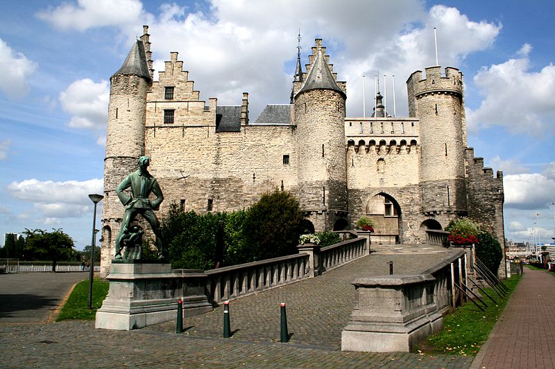 |
| Het Steen |
- The Cathedral of Our Lady. (Dutch: Onze-Lieve-Vrouwekathedraal) is a Roman Catholic cathedral started in 1352 and, although the first stage of construction was ended in 1521, has never been 'completed'. In Gothic style, its architects were Jan and Pieter Appelmans. It contains a number of significant works by the Baroque painter Peter Paul Rubens, as well as paintings by artists such as Otto van Veen, Jacob de Backer and Marten de Vos. Where the cathedral now stands, there was a small chapel of Our Lady from the 9th to the 12th century, which acquired the status of parish church in 1124. The cathedral is on the list of World Heritage Sites.
- Het Steen. A medieval fortress built after the Viking incursions in the early Middle Ages as the first stone fortress of Antwerp, Het Steen is Antwerp's oldest building and used to be its oldest urban centre. Previously known as Antwerpen Burcht (fortress), Het Steen gained its current name in around 1520, after significant rebuilding under Charles V. The rebuilding led to its being known first as "'s Heeren Steen" (the King's stone castle), and later simply as "Het Steen" (the stone castle). The fortress made it possible to control the access to the Scheldt, the river on whose bank it stands. It was used as a prison between 1303 and 1827. The largest part of the fortress, including dozens of historic houses and the oldest church of the city, was demolished in the 19th century when the quays were straightened to stop the silting up of the Scheldt. The remaining building, heavily changed, contains a shipping museum, with some old canal barges displayed on the quay outside.
- St. James' Church. Built on the site of a hostel for pilgrims to Santiago de Compostela. The present building is the work of the Waghemakere family and Rombout Keldermans, in Brabantine Gothic style. The church contains the grave of Rubens in the eastern chapel. In 1476 the chapel became a parish church so plans were made to replace the modest building with a large church. Fifteen years later, in 1491, construction of the late Gothic church started. It was not completed until 1656, when Baroque architecture was in vogue. Fortunately throughout all those years the architects closely followed the original Gothic design, hence the consistent Gothic exterior. The interior however is decorated in Baroque style.
- Antwerpen Central Station. is a major monument in Antwerp as it was the terminal for the oldest railway track in Belgium between Brussels and Antwerp via Mechelen. The architecture was designed by Louis Delacenserie in neo barque style with the help of marble, glass and stone. The platforms are sheltered by huge iron and glass domes. Its interiors can be compared to any European palace.
- The Brabo Statue. at the Grote Market is dedicated to Brabo who once saved the city from a giant named Antigoon, who used to chop off hands if travellers refused to pay toll for crossing the Scheldt River. It was Brabo who fought with giant and chopped off his hand and threw it in the river. The words ‘hand throwing’ when translated in dutch mean ‘Hantwerpen’, hence the city’s name ‘Antwerpen’. The statue holds a lot of symbolic value for Antwerp’s residents.

Central Station


The capital and largest city of Greece, Athens dominates the Attica region and is one of the world's oldest cities, as its recorded history spans around 3,400 years. Classical Athens was a powerful city-state. A centre for the arts, learning and philosophy, home of Plato's Academy and Aristotle's Lyceum, it is widely referred to as the cradle of Western civilization and the birthplace of democracy, largely due to the impact of its cultural and political achievements during the 5th and 4th centuries BC on the rest of the then known European continent.
.jpg)
The city that now hosts more than 4,5 million people, was constructed around the Acropolis walls. Today it is the political, social, cultural, financial and commercial centre of Greece. Cheap flights make it affordable and easy to reach Athens for vacation or business.
The core of the historical centre is the Plaka neighborhood (at the eastern side of the Acropolis), which has been inhabited since antiquity. Stroll through the narrow labyrinthine streets lined with houses and mansions from the time of the Turkish occupation and the Neoclassical period (19th c.), where you will discover endless picturesque tavernas, cafés, bars, as well as shops selling souvenirs and traditional Greek products.
Continuing from Plaka you arrive at Monastiraki, a characteristic area of “old” Athens, with narrow streets and small buildings where the city’s traditional bazaar (Yousouroum) is held. Close to it is the Psyrri area, a traditional neighborhood which during the past few years has evolved into one of the most important “centres” of the town’s nightlife, with scores of bars, tavernas, ouzeris, clubs, etc.
No matter how you feel about fish, meat and vegetables you won't find a more lively place than the Central market on Athinas Street. Whatever time of day you arrive, a walk through the market will probably change how you feel about shopping and may make you wish you had an apartment with a kitchen so you could join in. The restaurants in the meat market can't be beaten for good food at a cheap price at any time of the day or night. And if that is not enough the Market is also the beginning of Athens Chinatown and Eolou Street, the pedestrian shopping district.
The core of the historical centre is the Plaka neighborhood (at the eastern side of the Acropolis), which has been inhabited since antiquity. Stroll through the narrow labyrinthine streets lined with houses and mansions from the time of the Turkish occupation and the Neoclassical period (19th c.), where you will discover endless picturesque tavernas, cafés, bars, as well as shops selling souvenirs and traditional Greek products.
Continuing from Plaka you arrive at Monastiraki, a characteristic area of “old” Athens, with narrow streets and small buildings where the city’s traditional bazaar (Yousouroum) is held. Close to it is the Psyrri area, a traditional neighborhood which during the past few years has evolved into one of the most important “centres” of the town’s nightlife, with scores of bars, tavernas, ouzeris, clubs, etc.
 |
| Plaka |
A must do excursion out of the city is the Temple of Poseidon, God of the Sea, which boasts not only the carved grafitti of Lord Byron but one of the best sunsets after Santorini. Less than an hour away from Athens, on a hill overlooking the sea at the very tip of the Attiki Peninsula on a spot that could not be more perfect for an ancient site of worship. The best time to visit is in the late afternoon, take in meal or a drink and watch the sunset at one of Greece's most romantic locations.

Athens’s Top 5:
- The Parthenon. The temple on the Acropolis, dedicated to the Greek goddess Athena, whom the people of Athens considered their virgin patron. Its construction began in 447 BC when the Athenian Empire was at the height of its power. It was completed in 438 BC, although decorations of the Parthenon continued until 432 BC. It is the most important surviving building of Classical Greece, generally considered the culmination of the development of the Doric order. Its decorative sculptures are considered some of the high points of Greek art. The Parthenon is regarded as an enduring symbol of Ancient Greece and of Athenian democracy and one of the world's greatest cultural monuments
- The Temple of Hephaestus. Also known as the Hephaisteion or earlier as the Theseion, is the best-preserved ancient Greek temple; it remains standing largely as built. It is a Doric peripteral temple, and is located at the north-west side of the Agora of Athens, on top of the Agoraios Kolonos hill. From the 7th century until 1834, it served as the Greek Orthodox church of St. George Akamates.
- The Temple of Olympian Zeus. Also known as the Olympieion or Columns of the Olympian Zeus, is a colossal ruined temple that was dedicated to Zeus, king of the Olympian gods. Construction began in the 6th century BC during the rule of the Athenian tyrants, who envisaged building the greatest temple in the ancient world, but it was not completed until the reign of the Roman Emperor Hadrian in the 2nd century AD some 638 years after the project had begun. During the Roman periods it was renowned as the largest temple in Greece and housed one of the largest cult statues in the ancient world. The temple's glory was short-lived, as it fell into disuse after being pillaged in a barbarian invasion in the 3rd century AD. It was probably never repaired and was reduced to ruins thereafter. In the centuries after the fall of the Roman Empire, the temple was extensively quarried for building materials to supply building projects elsewhere in the city. Despite this, substantial remains remain visible today and it continues to be a major tourist attraction.
- The National Archaeological Museum. Houses some of the most important artifacts from a variety of archaeological locations around Greece from prehistory to late antiquity. It is considered one of the great museums in the world and contains the richest collection of artifacts from Greek antiquity worldwide. The first national archaeological museum in Greece was established by prime minister of Greece Ioannis Kapodistrias in Aigina in 1829. Since then the archaeological collection has been moved to a number of exhibition places until 1858, when an international architectural competition was announced for the location and the architectural design of the new museum. The current location was proposed and the construction of the museum's building began in 1866 and was completed in 1889 using funds from the Greek Government, the Greek Archaeological Society and the society of Mycenae.
- Zappeion Hall. A building in the National Gardens of Athens, generally used for meetings and ceremonies, both official and private. In 1869, the Greek Parliament allocated 80,000 square metres (860,000 sq ft) of public land between the Palace Gardens and the ancient Temple of Olympian Zeus, and also passed a law on 30 November 1869, "for the building works of the Olympic Games", as the Zappeion was the first building to be erected specifically for the revival of the Olympic Games in the modern world. The Zappeion was used during the 1896 Summer Olympics as the main fencing hall. A decade later, at the 1906 Summer Olympics, it was used as the Olympic Village. A number of historical events have taken place at the Zappeion, including the signing of the documents formalizing Greece's accession to the European Union on 1 January 1981, which took place in the building's marble-clad, peristyle main atrium. The Zappeion is currently being used as a Conference and Exhibition Center for both public and private purposes.

Zappeion Hall


References: http://www.greece-athens.com/
http://www.visitgreece.gr/en/main_cities/athens
http://www.athensguide.com

Avignon
Avignon is a French commune in southeastern France in the départment of the Vaucluse bordered by the left bank of the Rhône river.
Avignon, written as Avennio or Avenio in the ancient texts and inscriptions, takes its name from the Avennius clan. Founded by the Gallic tribe of the Cavares or Cavari, it became the centre of an important Phocaean colony from Massilia (present Marseilles).
Under the Romans, Avenio was a flourishing city of Gallia Narbonensis, the first Transalpine province of the Roman Empire, but very little from this period remains (a few fragments of the forum near Rue Molière).
During the inroads of the Goths, it was badly damaged in the fifth century and belonged in turn to the Goths, the kingdoms of Burgundy and of Arles, in the 12th century. It fell into the hands of the Saracens and was destroyed in 737 by the Franks under Charles Martel for having sided with the Arabs against him. Boso having been proclaimed Burgundian King of Provence, or of Arelat (after its capital Arles), by the Synod of Mantaille, at the death of Louis the Stammerer (879), Avignon ceased to belong to the Frankish kings.
 After the restoration of the Papacy in Rome, the spiritual and temporal government of Avignon was entrusted to a gubernatorial Legate, notably the Cardinal-nephew, who was replaced, in his absence, by a vice-legate (contrary to the legate usually a commoner, and not a cardinal). But Pope Innocent XII abolished nepotism and the office of Legate in Avignon on 7 February 1693, handing over its temporal government in 1692 to the Congregation of Avignon (i.e. a department of the papal Curia, residing at Rome), with the Cardinal Secretary of State as presiding prefect, and exercising its jurisdiction through the vice-legate. This congregation, to which appeals were made from the decisions of the vice-legate, was united to the Congregation of Loreto within the Roman Curia; in 1774 the vice-legate was made president, thus depriving it of almost all authority. It was done away with under Pius VI on 12 June 1790.
Avignon is commemorated by the French children's song, "Sur le pont d'Avignon" ("On the bridge of Avignon"), which describes folk dancing. The bridge of the song is the Saint Bénézet bridge, over the Rhône River, of which only four arches (out of the initial 22) remain which start from the Avignon side of the river. In fact people would have danced beneath the bridge (sous le pont) where it crossed an island (Île de Barthelasse) on its way to Villeneuve-lès-Avignon. The bridge was initially built between 1171 and 1185, with an original length of some 900 m (2950 ft), but it suffered frequent collapses during floods and had to be rebuilt several times. Several arches were already missing (and spanned by wooden sections) before the remainder were destroyed in 1660.


http://www.visitgreece.gr/en/main_cities/athens
http://www.athensguide.com
Avignon

Avignon is a French commune in southeastern France in the départment of the Vaucluse bordered by the left bank of the Rhône river.
Often referred to as the "City of Popes" because of the presence of popes and antipopes from 1309 to 1423 during the Catholic schism, it is currently the largest city and capital of the département of Vaucluse. This is one of the few French cities to have preserved its ramparts, its historic centre, the palace of the popes, Rocher des Doms, and the bridge of Avignon. It was classified a World Heritage Site by UNESCO under the criteria I, II and IV.
 The site of Avignon was settled very early on; the rocky outcrop (le Rocher les Doms) at the north end of the town, overlooking the Rhône River, may have been the site of a Celtic oppidum or hill fort.

Avignon, written as Avennio or Avenio in the ancient texts and inscriptions, takes its name from the Avennius clan. Founded by the Gallic tribe of the Cavares or Cavari, it became the centre of an important Phocaean colony from Massilia (present Marseilles).
Under the Romans, Avenio was a flourishing city of Gallia Narbonensis, the first Transalpine province of the Roman Empire, but very little from this period remains (a few fragments of the forum near Rue Molière).
During the inroads of the Goths, it was badly damaged in the fifth century and belonged in turn to the Goths, the kingdoms of Burgundy and of Arles, in the 12th century. It fell into the hands of the Saracens and was destroyed in 737 by the Franks under Charles Martel for having sided with the Arabs against him. Boso having been proclaimed Burgundian King of Provence, or of Arelat (after its capital Arles), by the Synod of Mantaille, at the death of Louis the Stammerer (879), Avignon ceased to belong to the Frankish kings.
In 1033, when Conrad II inherited the Kingdom of Arelat, Avignon passed to the Holy Roman Empire. With the German rulers at a distance, Avignon set up as a republic with a consular form of government, between 1135 and 1146. In addition to the Emperor, the Counts of Forcalquier, of Toulouse and of Provence exercised a purely nominal sway over the city; on two occasions, in 1125 and in 1251, the Counts of Toulouse and Provence divided their rights in regard to it, while the Count of Forcalquier resigned any right he possessed to the local Bishops and Consuls in 1135.
 At the end of the twelfth century, Avignon declared itself an independent republic, but independence was crushed in 1226 during the crusade against the Albigenses (the dualist Cathar heresy centred in neighboring Albi). After the citizens refused to open the gates of Avignon to King Louis VIII of France and the papal Legate, a three month siege ensued starting on 10 June 1226, and ending in capitulation by Avignon on 13 September 1226. Following the defeat, they were forced to pull down the ramparts and fill up the moat of the city.
On 7 May 1251 Avignon was made a common possession of counts Charles of Anjou and Alphonse de Poitiers, brothers of French king Saint Louis IX. On 25 August 1271, at the death of Alphonse de Poitiers, Avignon and the surrounding countship Comtat-Venaissin (which was governed by rectors since 1274) were united with the French crown.
Avignon and the Comtat did not become French until 1791. In 1274, the Comtat became a possession of the popes, with Avignon itself, self-governing, under the overlordship of the Angevin count of Provence (who was also king of "Sicily" [i.e., Naples]). The popes were allowed by the count of Provence (a papal vassal) to settle in Avignon in the early 14th century. The popes bought Avignon from the Angevin ruler for 80,000 florins in 1348. From then on until the French Revolution, Avignon and the Comtat were papal possessions, first under the schismatic popes of the Great Schism, then under the popes of Rome ruling via legates and vice-legates. The Black Death appeared at Avignon in 1348; killing almost two-thirds of the city's population.
 In 1309 the city, still part of the Kingdom of Arles, was chosen by Pope Clement V as his residence, and from 9 March 1309 until 13 January 1377 was the seat of the Papacy instead of Rome. This caused a schism in the Catholic Church. At the time, the city and the surrounding Comtat Venaissin were ruled by the kings of Sicily of the house of Anjou. The French King Philip the Fair, who had inherited from his father all the rights of Alphonse de Poitiers (the last Count of Toulouse), made them over to Charles II, King of Naples and Count of Provence (1290). Nonetheless, Phillip was a shrewd ruler. Inasmuch as the eastern banks of the Rhone marked the edge of his kingdom, when the river flooded up into the city of Avignon, Phillip taxed the city since during periods of flood, the city technically lay within his domain.

On 7 May 1251 Avignon was made a common possession of counts Charles of Anjou and Alphonse de Poitiers, brothers of French king Saint Louis IX. On 25 August 1271, at the death of Alphonse de Poitiers, Avignon and the surrounding countship Comtat-Venaissin (which was governed by rectors since 1274) were united with the French crown.
Avignon and the Comtat did not become French until 1791. In 1274, the Comtat became a possession of the popes, with Avignon itself, self-governing, under the overlordship of the Angevin count of Provence (who was also king of "Sicily" [i.e., Naples]). The popes were allowed by the count of Provence (a papal vassal) to settle in Avignon in the early 14th century. The popes bought Avignon from the Angevin ruler for 80,000 florins in 1348. From then on until the French Revolution, Avignon and the Comtat were papal possessions, first under the schismatic popes of the Great Schism, then under the popes of Rome ruling via legates and vice-legates. The Black Death appeared at Avignon in 1348; killing almost two-thirds of the city's population.


Avignon is commemorated by the French children's song, "Sur le pont d'Avignon" ("On the bridge of Avignon"), which describes folk dancing. The bridge of the song is the Saint Bénézet bridge, over the Rhône River, of which only four arches (out of the initial 22) remain which start from the Avignon side of the river. In fact people would have danced beneath the bridge (sous le pont) where it crossed an island (Île de Barthelasse) on its way to Villeneuve-lès-Avignon. The bridge was initially built between 1171 and 1185, with an original length of some 900 m (2950 ft), but it suffered frequent collapses during floods and had to be rebuilt several times. Several arches were already missing (and spanned by wooden sections) before the remainder were destroyed in 1660.

Avignon’s Top 5:
- Avignon Cathedral is a Roman Catholic cathedral, and a national monument of France, located in Avignon, above the Palais des Papes. It is the seat of the Archbishop of Avignon. The cathedral is a Romanesque building, mainly of the 12th century, the most prominent feature of which is the gilded statue of the Virgin Mary which surmounts the western tower. Among the many works of art in the interior, perhaps the most beautiful is the mausoleum of Pope John XXII, a masterpiece of Gothic carving of the 14th century.
- City Ramparts, built by the popes in the 14th century, still encircle Avignon and they are one of the finest examples of medieval fortification in existence. The walls of great strength are surmounted by machicolated sattlements, flanked at intervals by thirty-nine massive towers and pierced by several gateways, three of which date from the fourteenth century. The walls were restored under the direction of Eugène Viollet-le-Duc.
- La Fondation Calvet is an art foundation in Avignon, France, named for Esprit Calvet, who left his collections and library to it in 1810. The foundation maintains a museum and a library, with state support. The original legacies of paintings, archaeological items, coins and medals, and medieval sculpture have been added to by many other legacies, and a significant deposit of works of art from the Louvre. The archaeological collections and medieval sculpture are now housed separately in the "Musée Lapidaire" - once the chapel of the Jesuit College. The main museum is in an 18th century city mansion, to which modern buildings have been added; the Library bequeathed by Calvet, and the important collection of over 12,000 coins and medals, have moved to a different location in the city.
- The Pont Saint-Bénezet, also known as the Pont d'Avignon, is a famous medieval bridge. The bridge originally spanned the Rhône River between Avignon and Villeneuve-lès-Avignon on the left bank. It was built between 1171 and 1185, with an original length of some 900 m (2950 ft), but it suffered frequent collapses during floods and had to be reconstructed several times. Over the centuries, it became increasingly perilous as arches collapsed and were replaced by rickety wooden sections. The bridge was finally put out of use by a catastrophic flood in 1668, which swept away much of the structure. It was subsequently abandoned and no more attempts were made to repair it. Since then, its surviving arches have successively collapsed or been demolished, and only four of the initial 22 arches remain intact today.
- The Palais des Papes is a historical palace in Avignon, one of the largest and most important medieval Gothic buildings in Europe. Since 1995, the palais des Papes has been classified along with the historic center of Avignon, as a UNESCO World Heritage Site, under cultural criteria i, ii and iv. The Palais construction began in AD 1252. The site, on a natural rocky outcrop at the northern edge of Avignon, overlooking the river Rhône, was that of the old episcopal palace of the bishops of Avignon. The Palais was built in two principal phases with two distinct segments, known as the Palais Vieux(Old Palace) and Palais Neuf (New Palace). By the time of its completion, it occupied an area of 11,000 m² (2.6 acres). The building was enormously expensive, consuming much of the papacy's income during its construction. The Palais Vieux was constructed by the architect Pierre Poisson of Mirepoix at the instruction of Pope Benedict XII. The austere Benedict had the original episcopal palace razed and replaced with a much larger building centred on a cloister, heavily fortified against attackers. Its four wings are flanked with high towers.


I am one of your followers on Twitter and would like to put one of your stories on our site. www.holidaydestinationsaroundtheworld.com
ReplyDeleteWe are based in The Gold Coast, Queensland, Australia.
If you agree to this we would link this to your site and if you would like to continue to send us stories we would profile you as one of our travel writers. http://holidaydestinationsaroundtheworld.com/customPages/travel-writers?subSiteId=1
I see this as a win win situation and a great way to promote your website to a different audience throughout the world.
Please let me know your thoughts on this.
vi@holidaydestinationsaroundtheworld.com.au
Regards
Vi
Hi Vi. Thanks for your interest. I would be more than happy for you to use my content in return for a link back to site. let me know what you need.. cheers.. Tony
Delete