Nantes

Nantes is a city in western France, located on the Loire River, 50 km (31 mi) from the Atlantic coast. Nantes is the capital city of the Pays de la Loire region and Loire-Atlantique département. Together with Vannes, Rennes and Carhaix, it was one of the major cities of the historic province of Brittany, and the ancient Duchy of Brittany. Culturally, Nantes is a Breton city.
After having been occupied by the Gauls and the Romans, Nantes was Christianised in the 3rd century. The city was successively invaded by the Saxons (around 285), the Franks (around 500), the Britons (in the 6th and 7th centuries) and the Normans, who laid waste to it in 843: "The city of Nantes remained for many years deserted, devastated and overgrown with briars and thorns." The Chronicle of Nantes continues until about 1050 and it recounts that Alain Barbe-Torte, who was the grandson of Alan the Great, the last king of Brittany who was expelled by the Norse, drove them out and founded the Duchy of Brittany.

When the Duchy of Brittany was united to the kingdom of France in 1532 by the Treaty of Plessis-Macé, Nantes kept the Parliament of Brittany for a few years before it was moved to Rennes. In 1598, King Henry IV of France signed the Edict of Nantes here, which granted Protestants rights to their religion.
During the 18th century, prior to abolition of slavery, Nantes was the slave trade capital of France. This kind of trade led Nantes to become the largest port in France and a wealthy city. When the French Revolution broke out, Nantes chose to be part of it, although the whole surrounding region soon degenerated into an open civil war against the new republic known as the War in the Vendée. On 29 June 1793 the town was the site of a Republican victory in this war. The Loire was the site of thousands of executions by drowning, including those using the method which came to be known as the Republican marriage, in which a man and a woman were stripped naked, tied together, and thrown into the river.
In the 19th century, Nantes became an industrial city. The first public transport anywhere may have been the omnibus service initiated in Nantes in 1826. It was soon imitated in Paris, London and New York. The first railways were built in 1851 and many industries were created. In 1940, the city was occupied by German troops. In 1941, the assassination of a German officer, Lt. Col. Fritz Hotz, caused the retaliatory execution of 48 civilians. The city was twice severely bombed by British forces, on 16 and 23 August 1943, before being liberated by the Americans in 1944.

Until the 1970s, Nantes' harbour was located on the Île de Nantes, when it was moved to the very mouth of the Loire River, at Saint-Nazaire. In the subsequent 20 years, many service sector organisations moved into the area, but economic difficulties forced most of these to close. In 2001, a major redevelopment scheme was launched, the goal of which is to revitalise the island as the new city centre.
In 2003, the French weekly L'Express voted Nantes to be the "greenest city" in France, while in both 2003 and 2004 it was voted the "best place to live" by the weekly Le Point. In August 2004, TIME designated Nantes as "the most livable city in all of Europe.

In 2003, the French weekly L'Express voted Nantes to be the "greenest city" in France, while in both 2003 and 2004 it was voted the "best place to live" by the weekly Le Point. In August 2004, TIME designated Nantes as "the most livable city in all of Europe.
There's a vibrant atmosphere every night at dozens of cocktail bars, pubs and music bars in the Bouffay quarter. A few late-night clubs can also be found here, in the city centre and on the Ile de Nantes, especially at Hangar à Bananes. Most stay open until 2am, or 4am at weekends. The Lieu Unique in the city centre stages evening performances of drama, dance and classical music, and there's opera at Théâtre Graslin.
 |
| île Feydeau |
The main dining districts are the modern city centre and historic Graslin area. Both offer many affordable high-quality restaurants specialising in traditional French and regional cuisine. There's more sophisticated modern French or fusion dining too, notably at Nantes' premiere gastronomic name, L'Atlantide, on the waterfront of theSainte Anne quarter. Last orders for dinner are generally about 9pm or 10pm. Service is included in menu prices, so there's no need for an additional tip.
Nantes has dozens of chic fashion stores on Rue du Calvaire and more luxurious Rue Crébillon, in the smart Graslin quarter. Here too is elegant 19th-century shopping arcade Passage Pommeraye. You can mostly find specialists in local gourmet treats like chocolates or berlingots boiled sweets in the Graslin quarter and city centre, and the daily Talensac Market in the Talensacarea. Most shops open Tuesday to Saturday about 9.30am-7pm, often with an early afternoon break.

Nantes’ Top 5:
- Nantes Cathedral or the Cathedral of St. Peter and St. Paul, Nantes, is a Gothic Roman Catholic cathedral. The construction of the cathedral began in 1434, on the site of a Romanesque cathedral, and took 457 years to finish, finally reaching completion in 1891. The reconstruction of the cathedral commenced during the early to mid-15th century during a time when Nantes and Brittany were commercially prosperous, initiating such large-scale architectural projects on a wide scale, partly owing to the opportunist and skilful diplomatic policy of John VI in a period of political turmoil and conflict with England. The cathedral's foundation stone was laid on 14 April 1434, by John VI, Duke of Brittany and Jean de Malestroit, Bishop of Nantes (1417-1443). The first architect in charge was Guillaume de Dammartin who was later replaced by Mathurin Rodier. The construction began with the west façade, the aisles of the nave and its lateral chapels.
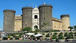
- The Château des ducs de Bretagne is a large castle located in the city of Nantes; it served as the centre of the historical province of Brittany until its separation in 1941. It is located on the right bank of the Loire, which formerly fed its ditches. It was the residence of the Dukes of Brittany between the 13th and 16th centuries, subsequently becoming the Breton residence of the French Monarchy. The castle has been listed as a monument historique by the French Ministry of Culture since 1862. Today the castle houses the Nantes History Museum. Starting in the 1990s, the town of Nantes undertook a massive programme of restoration and repairs to return the site to its former glory as an emblem of the history of Nantes and Brittany. Following 15 years of works and three years of closure to the public, it was reopened on 9 February 2007 and is now a popular tourist attraction.
- île Feydeau. The isle evokes the extravagant way of life the maritime traders led in the 18th century, when the port of Nantes was the biggest in France and one of the most important in Europe. Since 1926, it took nearly 20 years to fill-in the parts of the rivers Erdre and Loire that flowed round the ile Gloriette. From that moment on the isle lost its natural status and today strips of lawn bordered by granite show us where there was once the river. Someone forgot to tell the shipbuilders houses about the change and their sandy foundations no longer hold them up straight. Built mainly in limestone, decorated with ornamental façades and wrought-iron balconies with inner courtyards and vaulted staircases, the pomp of these houses indicates the importance of the city's former commercial trade. The buildings have two façades around an inner courtyard which opens on to the road and the quayside and from which rise beautiful stone staircases with wrought iron banisters. The balconies indicate how important a floor was; the ground floor was for commercial use only and is dominated by arched windows and reception rooms. Above were the finely decorated private apartments.
- The Musée Jules Verne is a museum dedicated to the French writer Jules Verne. The museum is housed in a beautiful late 19th century building, which overlooks the Loire River. While Verne never lived in the building, its surroundings reflect the atmosphere which influenced his work. The museum has a collection of artifacts, replicas of his inventions, and memorabilia inspired by his writings.
- Notre-Dame de Bon-Port is a basilica located in Nantes, constructed in 1846 by the architects Seheult and Joseph-Fleury Chenantais. Its official name is Église de Saint-Louis (Basilica of Saint-Louis), though it is rarely known by this name. The church is located at the Place du Sanitat, facing the Quai de la Fosse (Quay of the Pit). The dome which tops it is modelled on that of Les Invalides in Paris. At the top of the spire lies an archangel representing Saint Gabriel.

The Château des ducs de Bretagne


Naples

Naples, Napoli in Italian, is the third most-populated city in Italy and the biggest city in Southern Italy. Its close proximity to many interesting sites, such as Pompeii and the Bay of Naples, makes it a good base for exploring the area. Naples is a lively and vibrant city, full of wonderful historical and artistic treasures and narrow, winding streets with small shops, making it worth at least a few days visit.
Naples is in the region of Campania in Southern Italy, about 2-hours south of Rome. It sits on the coast on the northern edge of the Bay of Naples, one of the most beautiful bays in Italy. Its harbor is the most important port in Southern Italy. Vibrant, passionate, unique: words which perfectly describe the bay lying in the shadow of Vesuvius. A wonderful climate, a spectacular sea, and magnificent cities constructed centuries ago by the ancient civilisations who passed through the gulf, leaving behind them the traces of their art and architecture. The Bay of Naples, rich in archaeological, artistic, and monumental works, is renowned for the warmth of its inhabitants and their passion for music, dance, and the dramatic arts. From the vibrant and densely populated city of Naples to the elegant Sorrento and the ruins of Pompei, the bay offers a series of unique and unforgettable town and seascapes. Vying with the beauties of the mainland, across the water lie the three small islands of the gulf – Procida, Ischia, and Capri.
Click Here for Naples Travel Guides

Founded around the 9th century BC as a Greek colony, Naples is one of the oldest continuously inhabited cities in the world. Originally named Parthenope (Παρθενόπη) and later Neápolis (Νεάπολις – English: New City), it was among the foremost cities of Magna Graecia, playing a key role in the merging of Greek culture into Roman society. Naples eventually became part of the Roman Republic as a major cultural centre; the prominent Latin poet, Virgil, received part of his education in the city and later resided in its environs. As a microcosm of European history, the city has witnessed the rise and fall of numerous civilizations, each leaving traces in its art and architecture. Although many Greek and Roman ruins are in evidence in Naples and its surroundings, the most prominent forms of architecture now visible derive from the Medieval, Renaissance, and Baroque periods.

Spaccanapoli, or Via San Biagio, is the main street that divides Naples and is the heart of the historic center. Teeming with people, the street holds many interesting churches, shops, and other buildings. Originally the heart of the Greek and Roman city, the Spaccanapoli district is a string of narrow, winding streets and is mainly a pedestrian zone so its a fun place to wander around.
Follow the road to the end and you will find yourself in Via San Gregorio Armeno, off Via San Biagio, famous for its nativity workshops and stores. Via dei Tribunali, another street in old Naples, has arcades dating back more than 1000 years.
Naples is a city which exists on two levels, one above, and one beneath the surface. The city lies on partly hydrovolcanic, fine grained tuff, a light rock which is extremely easy to excavate and an important source of building material.
The Greeks were the first to exploit the qualities of tuff in 800 B.C, digging beneath their ancient "Neapolis", in order to construct an aqueduct linked to a series of cisterns via a web of tunnels. The Romans were responsible for the creation of a veritable"underground city", complete with cemeteries and temples
In the centuries which followed, and as the population of Naples grew, an incredible number of wells and cisterns were built beneath the city. Many of Naples' palazzi were erected above these sites, constructed using the deposits of tuff which had been produced during excavation.
The LAES, Libera Associazione Escursionisti Sotterranei organizes visits to underground Naples, which commence beneath the Quartieri Spagnoli, in Vico S.Anna di Palazzo 52.
From here, visitors descend some 40 meters to a large 3200sqm cavern, used during the second world war as bomb shelter, and then on to the ancient aqueduct of Carmignano, walking past the cisterns constructed by the Greeks and through a labyrinth of tunnels once connected to more than 4000 wells. Visitors are led beneath churches and palazzi, to the remains of an ancient Roman theatre, said to have been the favorite playhouse of Nero.
The guides describe how, in the past, every household accessed the water stored in the cisterns by way of domestic wells to which only the "pozzari", or well keepers, had access.
Another underground thoroughfare, only recently reopened to the general public, the Borbonica Sotterranea or the Bourbon Tunnel was initiated in 1853 by Royal Decree. The tunnel was designed to link Piazza Plebescito with the area of Chiaia, thus providing a quick escape route for the members of Bourbon dynasty and rapid point of access for troops arriving to protect the royal residences.
Getting to know Naples also means tasting its wonderful delicacies, being attracted by the strong tastes of the city’s cuisine. These tastes are the result of “contamination” by other cultures: over the centuries, the Arabs, Normans, Spanish and French all ruled the city, each contributing to the city’s gastronomic culture. The result is a unique type of cooking that continues to be halfway between refined and popular folk style, in which the local produce of this fertile area is prepared using elaborate recipes that often take a long time to prepare. The importation to Italy of the “New World” products in the sixteenth century: potatoes, peppers, beans, coffee and especially tomatoes, ingredients that are frequently used in Neapolitan cooking, was fundamental for the creation of the city’s traditional dishes.

Naples’s Top 5:
 |
| Piazza del Plebiscito (Picture by RaBoe/Wikipedia) |
- Pompeii and Herculaneum. Although neither are strictly in Naples, both are undoubtedly the foremost visitor attractions in the area and such must be mentioned. Pompei, along with Herculaneum and Stabiae , were partially destroyed and buried under 4 to 6 m (13 to 20 ft) of ash and pumice in the eruption of Mount Vesuvius in AD 79, and it was lost for nearly 1700 years before their accidental rediscovery in 1749. Since then, excavation has provided an extraordinarily detailed insight into the life of a city at the height of the Roman Empire. Today, this UNESCO World Heritage Site is one of the most popular tourist attractions of Italy, with approximately 2,500,000 visitors every year.
- The Duomo is a 13th century Gothic cathedral dedicated to Naple's patron saint, San Gennaro. A huge festival is held when a vial of his blood is taken out of its storage place in hopes that it will liquefy. On one side of the duomo is the 4th century Basilica Santa Restituta (the oldest church in Naples) with columns believed to be from the Temple of Apollo, good ceiling frescoes, and archaeological remains from the Greeks to the middle ages. The 5th century baptistery has good 14th century Byzantine-style mosaics.
- Castel Nuovo. Often called Maschio Angioino, is the main symbol of the architecture of the city. Castel Nuovo has been expanded or renovated several times since it was first begun in 1279.
Under the Aragonese dynasty, begun by Alfonso V in 1442, the fortress was updated to resist the new artillery. A famous triumphal arch, designed by Francesco Laurana, was added to the main gate to celebrate Alfonso's entrance in Naples. The decoration was executed by the sculptors Pere Johan and Guillem Sagrera, called by Alfonso from Catalonia. In a hall of the castle the famous Barons conspiracy against King Ferdinand I, Alfonso's son, occurred. The King had invited the barons for a feast; but, a certain point, he had the garrison close all the hall's doors and all the barons were arrested and later executed. The Barons' Hall was the seat of the Council of the commune of Naples until 2006. - The National Archaeological Museum of Naples has one of the world's best collections of Greek and Roman antiquities, including mosaics, sculptures, gems, glass and silver, and a collection of Roman erotica from Pompeii. Many of the objects come from excavations at Pompeii and other nearby archaeological sites
- Piazza del Plebiscito is the centre of modern Naples. San Francesco di Paola, on the piazza, is a huge domed church. Palazzo Reale, the Royal Palace, is across the square . Inside you can visit the restored rooms and royal apartments and visit the roof garden where there are good views of the bay.
 |
| Pompeii, click here for more info |
References: http://goitaly.about.com/od/naples/a/naples.htm
http://www.italytraveller.com
http://www.travelplan.it/naples_guide_e
Nice

Nice is the fifth most populous city in France and the second-largest French city on the Mediterranean coast after Marseille.
The city is called Nice la Belle (Nissa La Bella in Niçard), which means Nice the Beautiful, which is also the title of the unofficial anthem of Nice, written by Menica Rondelly in 1912. Nice is the capital of the Alpes Maritimes département and the second biggest city of the Provence-Alpes-Côte d'Azur region after Marseille.
The first known hominid settlements in the Nice area date back approximately 400,000 years; the Terra Amata archeological site shows one of the earliest uses of fire and construction of houses and flint findings are dated as around 230,000 years old. Nice (Nicaea) was probably founded around 350 BC by the Greeks of Massilia (Marseille), and was given the name of Νικαία ("Nikaia") in honour of a victory over the neighbouring Ligurians (Nike is the Greek goddess of victory). The city soon became one of the busiest trading ports on the Ligurian coast; but it had an important rival in the Roman town of Cemenelum, which continued to exist as a separate city until the time of the Lombard invasions. The ruins of Cemenelum are located in Cimiez, which is now a district in Nice.

In the 7th century, Nice joined the Genoese League formed by the towns of Liguria. In 729 the city repulsed the Saracens; but in 859 and again in 880 the Saracens pillaged and burned it, and for most of the 10th century remained masters of the surrounding country.
During the Middle Ages, Nice participated in the wars and history of Italy. As an ally of Pisa it was the enemy of Genoa, and both the King of France and the Emperor endeavoured to subjugate it; but in spite of this it maintained its municipal liberties. During the course of the 13th and 14th centuries the city fell more than once into the hands of the Counts of Provence, but finally remained independent even if related to Genoa.
In 1388 the commune placed itself under the protection of the Counts of Savoy. Nice participated – directly or indirectly – in the history of Savoy up until 1860.
The maritime strength of Nice now rapidly increased until it was able to cope with the Barbary pirates; the fortifications were largely extended and the roads to the city improved. In 1561 Emmanuel Philibert, Duke of Savoy, abolished the use of Latin as an administrative language and established the Italian language as the official language of government affairs in Nice.
The maritime strength of Nice now rapidly increased until it was able to cope with the Barbary pirates; the fortifications were largely extended and the roads to the city improved. In 1561 Emmanuel Philibert, Duke of Savoy, abolished the use of Latin as an administrative language and established the Italian language as the official language of government affairs in Nice.

In 1543, Nice was attacked by the united Franco-Ottoman forces of Francis I and Barbarossa Hayreddin Pasha, in the Siege of Nice; and, though the inhabitants repulsed the assault which succeeded the terrible bombardment, they were ultimately compelled to surrender, and Barbarossa was allowed to pillage the city and to carry off 2,500 captives. Pestilence appeared again in 1550 and 1580.
In 1600, Nice was briefly taken by the duke of Guise. By opening the ports of the county to all nations, and proclaiming full freedom of trade (1626), the commerce of the city was given great stimulus, the noble families taking part in its mercantile enterprises.
Captured by Nicolas Catinat in 1691, Nice was restored to Savoy in 1696; but it was again besieged by the French in 1705, and in the following year its citadel and ramparts were demolished.
The treaty of Utrecht in 1713 once more gave the city back to the Duke of Savoy who was on that same occasion recognized as King of Sicily. In the peaceful years which followed the "new town" was built. From 1744 till the peace of Aix-la-Chapelle (1748) the French and Spaniards were again in possession. In 1775 the king, who in 1718 had swapped his sovereignty of Sicily for the Kingdom of Sardinia, destroyed all that remained of the ancient liberties of the commune. Conquered in 1792 by the armies of the First French Republic, the County of Nice continued to be part of France until 1814; but after that date it reverted to the Kingdom of Sardinia-Piedmont.
By a treaty concluded in 1860 between the Sardinian king and Napoleon III, the County was again ceded to France as a territorial reward for French assistance in the Second Italian War of Independence against Austria, which saw Lombardy unified with Piedmont-Sardinia. The cession was ratified by over 25,000 electors out of a total of 30,700. Savoy was also transferred to the French crown by similar means. Giuseppe Garibaldi, born in Nice, strongly opposed the cession to France (arguing that the ballot was rigged by the French). Italian irredentists considered Nice one of their main nationalist goals, along with Istria, Dalmatia, Corsica and the South Tyrol. In 1942–1943 the city was occupied and administered by Italy during World War II.
Nice has a few local dishes. There is a local tart made with onions and anchovies (or anchovy paste), named "Pissaladière". Socca is a type of pancake made from chickpea flour. Farcis niçois is a dish made from vegetables stuffed with a mixture of breadcrumbs, meat (generally sausage and ground beef), and herbs; and salade niçoise is a tomato salad with green peppers of the "Corne" variety, baked eggs, tuna or anchovies, and olives.
Local meat comes from neighbouring valleys, such as the sheep of Sisteron. Local fish, such as mullets, bream, sea urchins, and anchovies (alevins) are used to a great extent, so much so that it has given birth to a proverb: "fish are born in the sea and die in oil"
Although the beaches are mainly pebbles it is important to note that many visitors enjoy the beautiful light blue sea for a swim. If you can bear to walk for few steps on the pebbles it is definitely an opportunity for swimming rather than playing in the water as the beach drops quickly and the tidal pull can be very strong, and not for beginners. Lying on the beach for a sun tan or relaxation is also manageable as long as you rearrange the rocks/pebbles to a comfy surface for sitting and lying. Private beaches offer various services from restaurants/bars to the rental of lounge chairs and towels.
In 1600, Nice was briefly taken by the duke of Guise. By opening the ports of the county to all nations, and proclaiming full freedom of trade (1626), the commerce of the city was given great stimulus, the noble families taking part in its mercantile enterprises.
Captured by Nicolas Catinat in 1691, Nice was restored to Savoy in 1696; but it was again besieged by the French in 1705, and in the following year its citadel and ramparts were demolished.
The treaty of Utrecht in 1713 once more gave the city back to the Duke of Savoy who was on that same occasion recognized as King of Sicily. In the peaceful years which followed the "new town" was built. From 1744 till the peace of Aix-la-Chapelle (1748) the French and Spaniards were again in possession. In 1775 the king, who in 1718 had swapped his sovereignty of Sicily for the Kingdom of Sardinia, destroyed all that remained of the ancient liberties of the commune. Conquered in 1792 by the armies of the First French Republic, the County of Nice continued to be part of France until 1814; but after that date it reverted to the Kingdom of Sardinia-Piedmont.
By a treaty concluded in 1860 between the Sardinian king and Napoleon III, the County was again ceded to France as a territorial reward for French assistance in the Second Italian War of Independence against Austria, which saw Lombardy unified with Piedmont-Sardinia. The cession was ratified by over 25,000 electors out of a total of 30,700. Savoy was also transferred to the French crown by similar means. Giuseppe Garibaldi, born in Nice, strongly opposed the cession to France (arguing that the ballot was rigged by the French). Italian irredentists considered Nice one of their main nationalist goals, along with Istria, Dalmatia, Corsica and the South Tyrol. In 1942–1943 the city was occupied and administered by Italy during World War II.
 |
| The Monument to the Dead at the foot of Castle Hill |
Modern Nice's main shopping street is av Jean Medecin. Designer label garments are as everywhere notoriously expensive but general fashion goods are really cheap compared to most other European countries, and Galleries Lafayette offers a lot under one roof. If that's not enough for you, they also have a huge superstore at Cap 3000 just next to St Laurent de Var past the airport (Lignes d Azur 52 and TAM bus 200, 400 and 500, stop La Passerelle). This is also home to Galleries Lafayette Gourmand, a food superstore to rival Londons Harrods and Selfridges. The wine selection is brilliant, especially aisles full of Rose de Provence, and there are a half dozen in-store lunch-time places.
Cheap bargain fashions are best sought at Ventimiglia's huge open street market each Friday, accessible by train from Nice Gare Ville to Ventimiglia a few kilometres over the Italian border. Just avoid the tempting fake luxury brands sold by the many street sellers. The war against counterfeiting is taken very seriously by the French border police and big fines are targeted at "innocent" tourists.
The central Nice Etoiles is available for anyone pining for a visit to a shopping mall, including three floors of an old British brand not seen for twenty years that is still big in France - C&A. More nostalgia can also be found in av Jean Medecins' "Damart" - yes, the people that gave you "thermoclactic underwear" to keep you warm in Winter are also big here. About as sensible as the local "Bronzage" tanning parlours.
 The cuisine of Nice is especially close to those of Provence but also Liguria and Piedmont and uses local ingredients (olive oil, anchovies, fruit and vegetables) but also those from more remote regions, in particular from Northern Europe, because ships which came to pick up olive oil arrived full of food products, such as dried haddock.
The central Nice Etoiles is available for anyone pining for a visit to a shopping mall, including three floors of an old British brand not seen for twenty years that is still big in France - C&A. More nostalgia can also be found in av Jean Medecins' "Damart" - yes, the people that gave you "thermoclactic underwear" to keep you warm in Winter are also big here. About as sensible as the local "Bronzage" tanning parlours.

Nice has a few local dishes. There is a local tart made with onions and anchovies (or anchovy paste), named "Pissaladière". Socca is a type of pancake made from chickpea flour. Farcis niçois is a dish made from vegetables stuffed with a mixture of breadcrumbs, meat (generally sausage and ground beef), and herbs; and salade niçoise is a tomato salad with green peppers of the "Corne" variety, baked eggs, tuna or anchovies, and olives.
Local meat comes from neighbouring valleys, such as the sheep of Sisteron. Local fish, such as mullets, bream, sea urchins, and anchovies (alevins) are used to a great extent, so much so that it has given birth to a proverb: "fish are born in the sea and die in oil"
 |
| Waterfall at Colline du Chateau |
If you go to Nice for bathing or general lounging on the beach, you may wish to think again. The beaches of Nice consist entirely of large flat stones ("gallets"). A few private beaches have added a layer of sand, but the free public beaches are a stony experience. Besides towels or mats, you should definitely bring sandals as walking on the stones can be painful, and a cushion, if you want to sit. Showers are provided (for free) on all public beaches and there is a beach volleyball area that is netted off with white sand.
Although the beaches are mainly pebbles it is important to note that many visitors enjoy the beautiful light blue sea for a swim. If you can bear to walk for few steps on the pebbles it is definitely an opportunity for swimming rather than playing in the water as the beach drops quickly and the tidal pull can be very strong, and not for beginners. Lying on the beach for a sun tan or relaxation is also manageable as long as you rearrange the rocks/pebbles to a comfy surface for sitting and lying. Private beaches offer various services from restaurants/bars to the rental of lounge chairs and towels.
 |
| The Basilica of Notre Dame |
Nice’s Top 5:
- Nice Cathedral is the cathedral of the Diocese of Nice. It was built between 1650 and 1699, the year of its consecration. It is dedicated to the Assumption of the Virgin Mary and Saint Reparata. It has been classed as a monument historique since 9 August 1906. The first church on the site was built in the early 13th century on land belonging to the Abbey of St. Pons and became a parish church in 1246. During the first half of the 16th century a series of acts gradually effected the transfer of the seat of the bishops of Nice from Cimiez Cathedral on the hill of the castle overlooking the city to the church of Saint Reparata which in 1590, after an official ceremony presided over by the then bishop, Luigi Pallavicini, and in the presence of Charles Emmanuel I, Duke of Savoy, was recognised as a chiesa-cattedrale. However, in 1649, judging the building too small, bishop Didier Palletis commissioned the architect Jean-André Guibert to produce a structure more in keeping with the importance of the city. The cathedral was declared a minor basilica on 27 May 1949.
- The Musée des Beaux-Arts de Nice at 33 av. des Baumettes was built in the former private mansion built in 1878 by the Ukrainian Princess, Elisabeth Vassilievna Kotschoubey. Named for the artist Jules Chéret who lived and worked in Nice during his final years, the museum opened in 1928. The museum houses a collection of art spanning the past four centuries. There are paintings by Chéret and other artists who lived and worked on the French Riviera such as Gustav Adolf Mossa, who for many years was curator of the museum. The small museum has sculptures by Jean-Baptiste Carpeaux, François Rude, Michel de Tarnowsky and Auguste Rodin, plus ceramic pieces by Pablo Picasso.
- The Observatoire de Nice (Nice Observatory) is located on the summit of Mont Gros. The observatory was initiated in 1879 by the banker Raphaël Bischoffsheim. The architect was Charles Garnier, and Gustave Eiffel designed the main dome. The 76-cm (30-inch) refractor telescope that became operational in 1888 was at that time the world's largest telescope. It was outperformed one year later by the 36-inch (91-cm) refractor at the Lick Observatory at University of California, Santa Cruz.
- The Basilica of Notre-Dame de Nice is a Roman Catholic Neo-Gothic basilica situated on the Avenue Jean-Médecin in the centre of Nice. The basilica, built between 1864 and 1868, was designed by Louis Lenormand and is the largest church in Nice, but is not the cathedral. Inspired by Angers Cathedral, it is built in the Gothic style. Its construction was motivated by a desire to frenchify the city after the County of Nice was annexed to France from Italy, and at the time Gothic buildings were supposed to be characteristically French. Its most prominent features are the two square towers 65m high, which dominate the east front together with a large rose window featuring scenes of the Assumption of Mary.
- The Colline du Chateau overlooking the Baie des Anges and harbour offers a spectacular vantage point overlooking the city. Not much is left of its ruined castle besides crumbling walls. Still, climbing up the stairs to reach the platforms 90 metres above Nice is well worth the view. There is also an ascenseur (lift) which will take you three quarters of the way up. Be aware that the castle "park" closes at around sunset. Expect to be escorted outside if you stay longer.


Nicosia

Nicosia, known locally as Lefkosia, is the capital and largest city in Cyprus, as well as its main business center. After the collapse of the Berlin Wall, Nicosia remained the only divided capital in the world, with the southern and the northern portions divided by a Green Line. It is located near the center of the island, on the banks of the Pedieos River.
Nicosia is the capital and seat of government of the Republic of Cyprus. The northern part of the city functions as the capital of the self-proclaimed Turkish Republic of Northern Cyprus, a disputed breakaway region whose independence is recognized only by Turkey, and which the rest of the international community considers as occupied territory of the Republic of Cyprus since the Turkish Invasion in 1974.
Nicosia has been in continuous habitation since the beginning of the Bronze Age 2500 years BC, when the first inhabitants settled in the fertile plain of Mesaoria. Nicosia later became a city-state known as Ledra or Ledrae, one of the twelve kingdoms of ancient Cyprus built by Achaeans after the end of the Trojan War. Remains of old Ledra today can be found in the Ayia Paraskevi hill in the south east of the city. We only know about one king of Ledra, Onasagoras. The kingdom of Ledra was destroyed early. Under Assyrian rule of Cyprus, Onasagoras, was recorded as paying tribute to Esarhaddon of Assyria in 672 BC. Rebuilt by Lefkonas, son of Ptolemy I around 300 BC, Ledra is described as a small and unimportant town, also known as Lefkotheon. The main activity of the town inhabitants was farming. During this era, Ledra did not have the huge growth that the other Cypriot coastal towns had, which was primarily based on trade.

In Byzantine times the town was also referred to as Lefkousia and also as Kallinikisis. In the 4th century AD, the town became the seat of bishopship, with bishop Saint Tryphillius (Trifillios), a student of Saint Spyridon.
After the destruction of Salamis by Arab raids in 647, the existing capital of Cyprus, Nicosia became the capital of the island around 965, when Cyprus rejoined the Byzantine Empire. The Byzantines moved the islands administration seat to Nicosia, primarily for security reasons as coastal towns were often suffering from raids. Since then it remains as the capital of Cyprus. Nicosia had acquired a castle and was the seat of the Byzantine governor of Cyprus. The last Byzantine governor of the Island was Isaac Comnenus who declared himself emperor of the island and ruled the island from 1183–1191.

In 1960 Nicosia became the capital of the Republic of Cyprus, whose constitution was based on the co-operation of the island's two main communities, Greek and Turkish Cypriots. In December 1963, during the aftermath of a constitutional crisis, skirmishes broke out between Greek Cypriots and the Turkish Cypriots. Nicosia was divided into Greek and Turkish Cypriot quarters. The dividing line, which cuts through the city, was named Green line because the pen used by the United Nations officer to draw the line on a city map was green.

Without a doubt, the 1000 year old capital should be on every visitor's agenda. It lies roughly in the centre of the island, within easy reach of the other towns. A day in Nicosia will be a day well spent. To walk through the old city is to step backwards in time. Narrow streets and old houses with ornate balconies jut from weather beaten sandstone walls, and craftsmen in small workshops practice trades unchanged for centuries.
Apart from the unique places of interest left from the ancient times with memories of many generations, the present Nicosia is a dynamic metropolitan city with highly developed infrastructure and an attractive modern look. The uniqueness of such combination makes the capital of Cyprus a place worth knowing and certainly a place worth visiting.


After the destruction of Salamis by Arab raids in 647, the existing capital of Cyprus, Nicosia became the capital of the island around 965, when Cyprus rejoined the Byzantine Empire. The Byzantines moved the islands administration seat to Nicosia, primarily for security reasons as coastal towns were often suffering from raids. Since then it remains as the capital of Cyprus. Nicosia had acquired a castle and was the seat of the Byzantine governor of Cyprus. The last Byzantine governor of the Island was Isaac Comnenus who declared himself emperor of the island and ruled the island from 1183–1191.
 |
| Selimiye Mosque |
On his way to the Holy Land during the Third Crusade in 1187, Richard I of England fleet was plagued by storms. He himself stopped first at Crete and then at Rhodes. Three ships continued on, one of which was carrying Queen Joan of Sicily and Berengaria of Navarre, Richard's bride-to-be. Two of the ships were wrecked off Cyprus, but the ship bearing Joan and Berengaria made it safely to Limassol. Joan refused to come ashore, fearing she would be captured and held hostage by Isaac Comnenus, who hated all Franks. Her ship sat at anchor for a full week before Richard finally arrived on the 8th of May. Outraged at the treatment of his sister and his future bride, Richard invaded.
Richard laid siege to Nicosia. Richard finally met and defeated Isaac Comnenus at Tremetousia. Richard became ruler of the island but sold the island to the Knights Templar. The Knights Templar ruled the island having bought it from Richard the Lionheart for 100.000 gold byzantiums. Their seat was the castle of Nicosia. On Easter day on the 11th of April 1192 the people of Nicosia revolted and drove the Knights Templar off the city. Having driven the Knights Templar away, fearing their return the Nicosians demolished the castle of the city almost to its foundations.
Guy of Lusignan, King of Jerusalem, bought Cyprus from the Knights Templar and brought many noble men and other adventurers, from France, Jerusalem, Tripoli, the Principality of Antioch and Kingdom of Armenia, to the island. The Frankish rule of Cyprus started from 1192 and lasted until 1489. During this time, Nicosia was the capital of the medieval Kingdom of Cyprus, the seat of Lusignan kings, the Latin Church and the Frankish administration of the island. During the Frankish rule, the walls of the city were built along with many other palaces and buildings, including the gothic Saint Sofia Cathedral. The tombs of the Lusignan kings can be found there.

In 1489 Cyprus was captured by the Republic of Venice. Nicosia was their administrative centre and the seat of the Venetian Governor. Since the threat from the Ottomans was visible, the Venetian Governors of Nicosia emphasized in their letters the need for all the cities of Cyprus to be fortified. In 1567 Venetians built the new fortifications of Nicosia, which are well-preserved until today, demolishing the old walls built by the Franks as well as other important buildings of the Frankish era including the King's Palace, other private palaces and churches and monasteries of both Orthodox and Latin Christians. The new walls took the shape of a star with eleven bastions. The design of the bastion is more suitable for artillery and a better control for the defenders. The river Pedieos used to flow through the Venetian walled city. In 1567 it was later diverted outside onto the newly built moat for strategic reasons, due to the expected Ottoman attack.
On July 1 st 1570 the Ottomans invaded the island. On the 22nd of July, Piale Pasha having captured Paphos, Limassol and Larnaca marched his army towards Nicosia and laid siege to the city. The city managed to last 40 days under siege until its fall on 9 September 1570. Some 20,000 residents died during the sige and every church, public building, and palace was looted. After its siege it was reported that the walls that were ruined, Nicosia retained very few inhabitants. The main Latin churches were converted into mosques, such as the conversion of Saint Sofia Cathedral into the Selimiye Mosque. From 1570 when the Ottomans took over Nicosia, the old river bed through the walled city was left open and was used as a dumping ground for refuse, where rainwater would rush through clearing it temporarily.
 |
| The House of Hadjigeorgakis Kornessios |
At the time of British administration, Nicosia was still contained entirely within its Venetian walls. Although full of private gardens and amply supplied with water carried to public fountains in aqueducts, the streets remained unpaved and just wide enough for a loaded pack animal. In 1881, macadamized roads through the town were completed to connect with the main roads to the coastal towns but no roads were asphalted until after World War I. On 5 July 1878 the administration of the island was officially transferred to Great Britain. On 31 July 1878, Garnet Wolseley, the first High Commissioner, arrived in Nicosia. He immediately established a skeletal administration by sending officers to each district to supervise the administration of justice and obtain all possible information about the area. Garnet Wolseley immediately established a Post Office at his camp at Kykko Metochi monastery outside Nicosia. Garnet Wolseley lived at ‘Monastery Camp' until a prefabricated residence had been built for him near Strovolos on the site of today's Presidential Palace.
In 1955 an armed struggle against the British rule began aiming to unite the island with Greece, Enosis. The struggle was led by EOKA, a Greek Cypriot nationalist military resistance organisation, and supported by the vast majority of Greek Cypriots. The unification with Greece failed and instead the independence of Cyprus was declared in 1960. During the period of the struggle, Nicosia was the scene of violent protests against the British rule.
In 1955 an armed struggle against the British rule began aiming to unite the island with Greece, Enosis. The struggle was led by EOKA, a Greek Cypriot nationalist military resistance organisation, and supported by the vast majority of Greek Cypriots. The unification with Greece failed and instead the independence of Cyprus was declared in 1960. During the period of the struggle, Nicosia was the scene of violent protests against the British rule.
In 1960 Nicosia became the capital of the Republic of Cyprus, whose constitution was based on the co-operation of the island's two main communities, Greek and Turkish Cypriots. In December 1963, during the aftermath of a constitutional crisis, skirmishes broke out between Greek Cypriots and the Turkish Cypriots. Nicosia was divided into Greek and Turkish Cypriot quarters. The dividing line, which cuts through the city, was named Green line because the pen used by the United Nations officer to draw the line on a city map was green.

On the 15th July 1974, there was an attempted coup d'état led by the Greek military junta to unite the island with Greece. The coup ousted president Makarios III and replaced him with pro-enosis nationalist Nikos Sampson.
On the 20th July 1974, the Turkish army invaded the island on the pretext of restoring the constitutional order of the Republic of Cyprus. However, even after the restoration of constitutional order and the return of Archbishop Makarios III to Cyprus in December 1974, the Turkish troops remained on the island occupying the northeastern portion of the island. The invasion was given the codename Operation Attila and included two phases.
The second phase of the Turkish invasion was performed on the 14th August 1974, where the Turkish army advanced their positions, eventually capturing a total of 37% of Cypriot territory including the northern part of Nicosia and the cities of Kyrenia and Famagusta. The fighting left the island with a massive refugee problem. Out of a population of 600,000, an estimated 200,000 Greek-Cypriots had been uprooted and forced to flee south of the Attila line, while an estimated 60,000 Turkish-Cypriots remained south of the Attila line, uncertain of their fate.
On February 13, 1975 the Turkish Cypriot community declared the Turkish Federated State of Cyprus in the area occupied by Turkish forces. On November 15, 1983, Turkish Cypriots proclaimed their independence as the Turkish Republic of Northern Cyprus.
 |
| Makarios III |
The Turkish invasion, the continuous occupation of Cyprus as well as the self-declaration of independence of the TRNC have been condemned by several United Nations Resolutions adopted by the General Assembly and the Security Council. The Security Council is reaffirming their condemnation every year.
Despite the division Nicosia has managed to become a sophisticated and cosmopolitan city, rich in history and culture that combines its historic past with the amenities of a modern city.
Apart from the unique places of interest left from the ancient times with memories of many generations, the present Nicosia is a dynamic metropolitan city with highly developed infrastructure and an attractive modern look. The uniqueness of such combination makes the capital of Cyprus a place worth knowing and certainly a place worth visiting.
The traditional shopping district runs along Ledra street and its tributary roads within the medieval walls of the city. A bustle of traditional jewelers, shoe and fabric shops give a blend of Middle Eastern and European feel.Laiki Geitonia is a pedestrianised neighbourhood that has been preserved in its original architecture and is the best quarter if you are after souvenir shops. Big chains (e.g. Marks and Spencer, Zara etc) line the more modern Makariou Avenue. Stasikratous street has evolved into a mini local version of 5th Avenue/Bond street with expensive brands such as Armani and Versace stores. All the above are within walking distance of each other.
There are no real department stores in a purist sense, but Ermes (this chain inherited and re-branded the old local Woolworths) has several mini department stores across the island and a couple on Makarios Avenue. Alpha-Mega and Orphanides are local hypermarket chains (worthy equivalent of a Tesco or Wal-Mart) where it would be difficult not to find what you were after. Most of their stores however, are located in the suburbs.
There are no real department stores in a purist sense, but Ermes (this chain inherited and re-branded the old local Woolworths) has several mini department stores across the island and a couple on Makarios Avenue. Alpha-Mega and Orphanides are local hypermarket chains (worthy equivalent of a Tesco or Wal-Mart) where it would be difficult not to find what you were after. Most of their stores however, are located in the suburbs.
 |
| Ledra Street |
Traditional Cypriot cuisine is a melting pot of south European, Balkan and Middle Eastern influences. You will find most Greek, Turkish and Arabic dishes, often with a local name or twist. It is now decades since Cyprus has established itself as a tourist hotspot and as a consequence many of the local chefs have trained in Europe and elsewhere, bringing their experiences back home with them. As such most international cuisines are well represented (but unfortunately so are McDonalds & gang). In summary good food is not difficult to come by and most westerners will find dining quite affordable.
The shopping district is dotted with local tavernas and the likes of KFC and Pizza Hut. Virtually all restaurants allow smoking, (and unfortunately some don't even have a non-smoking area, and most restaurants with the non-smoking area don't enforce it). Al fresco dining is a luxury that can be enjoyed for over half the year. It would be a crime not to try (at least once) a mixed pork kebab with a chilled local KEO or Carlsberg (which is brewed locally and tastes different to the same brand overseas) beer. Carnivores are spoilt for choice, whilst vegetarians might find it a tad difficult.
The food is high quality and somewhat cheaper than in the most Western capitals. Snacks should be available from €2-4, kebabs from €7 and whole meals from €15-20. Local KEO beer costs around €4 a pint in bars, local wines starting from €10 a bottle. Hygienic standards are followed and even foods that usually are not recommended in the Mediterranean destinations, such as mayonnaise and salad-based foods, can be safely eaten.
The substantial student population supports a flourishing industry of bars, pubs and nightclubs which keep the old city alive. Cypriots are true socialites and spend most of their time out as opposed to at home. In line with other south European countries going out is unheard of before 10-11pm. There is no official nightlife reference point but Makarios avenue turns into a catwalk cum cruising strip for Porsche owner show-offs. If you are after a more traditional flavour (generally catering for an older population) you could try a bouzouki bar.
Bars will stock the usual international brands of spirits. Local giants KEO beer and Carlsberg (the only other brand brewed on the island) have a universal presence. Local wines are now making a comeback after years of medioaracy and decline. Commandaria is the pride of Cyprus' dessert wines. The local spirit zivania (very similar to grappa) is usually drank as shots straight from the freezer. Cyprus brandy was introduced about 150 years ago and differs from other continental brandies in its lower alcohol content (around 32%). As such it is is often drank by locals whilst eating (and before and after) and is the basic ingredient for a local cocktail, The Brandy Sour. Local Ouzo is also another favourite.
Coffee culture is a way of life in Nicosia. It is the place to see and be seen in the afternoon to early evening. In the summer months, tables spill on to the streets. The posh cafes line Makarios avenue, intertwined with shops. Starbucks and Costa coffee have invaded the island but local equivalents also survive. For a change don't stick to the latte/capuccino, try a greek coffee. In the summer you must order a frappe (iced coffee).

Nicosia’s Top 5:
- Ayios Ioannis Cathedral. Is within the Archbishopric, Arch. Kyprianos Square. built by Archbishop Nikiforos in 1662, the recently restored 18th century wall paintings depict biblical scenes and the discovery of the tomb of Saint Barnabas at Salamis. Dedicated to Ayios loannis (Saint John). The archbishopric is the centre of the Cyprus Orthodox Church, the new Archbishopric built in a neo-byzantine style in 1960, contains the private suite of the late Archbishop Makarios. Open to the public only on special occasions.
- Selimiye Mosque or Agia Sofia Cathedral, formerly Cathédrale Sainte Sophie, is located in the Turkish controlled northern part of the walled city of Nicosia. It is the main mosque in the city. Possibly constructed on the site of an earlier Byzantine church. The building belongs to the pure Gothic style of the beginning of the 12th century. Due to the building’s large scale, lack of money and various historical events it took 150 years for the cathedral to be built and still, it was never entirely completed since the southwest tower and the portico’s upper floor were never constructed. The cathedral’s first construction phase began during the first years of Frankish rule (possibly in 1209) and already by 1228 the eastern part of the building was completed. By the end of the 13th century the side aisles and a large part of the middle aisle were completed. From 1319 to 1326 the Latin archbishop Giovanni del Conte or Giovanni de Polo was responsible for the completion of the middle aisle, the construction of the roof buttresses, the cathedral’s façade and the building of a chapel (which functioned as a baptistery) in the western part of the southern wall. He also adorned parts of the cathedral with frescoes and sculptures. In November 1326 the cathedral’s official inauguration took place.
- The Venetian City Walls. This fortification complex has a circumference of 3 miles, and contains eleven pentagon-shaped bastions named after eleven families, pillars of the Italian aristocracy of the town, who donated funds towards the construction of the walls and the three gates, Porta San Domenico Paphos Gate, Porta Guiliana -Famagusta Gate, and Porta del Proveditore -Kyrenia Gate-. Experts contemporary to the construction of the walls have considered them as a prime example of 16th century military architecture. Their design incorporates specific innovative techniques, marking the beginning of a renaissance era in fortification construction. These include the positioning of gates to the side of the adjoining bastions, so they could be more easily protected in times of siege, and leaving the upper half of the wall unlined with masonry, so as to increase its ability to absorb the impact from cannon shot.
- Cyprus Museum. This museum was established to collect, study and display archaeological artifacts from all over the island. Some of the exhibits are as old as 8,500 years. The museum is arranged in chronological order. The first hall contains pottery and implements from the Neolithic and Chalcolithic periods whilst the other rooms trace the history of Cyprus through the ages from the Bronze Age, Hellenic Period, Mycenaean times, and Roman Period to the earlyByzantine. A unique feature of the museum lies in the basement, where several graves rest in a dark cellar complete with skeletal remains and grave adornments that have been reconstructed.
- The House of Hadjigeorgakis Kornessios. Originally a Venetian Building. It is probably the most important 18th century building in Nicosia. It was once the house of the Dragoman Hadjigeorgakis Kornessios. The house is being restored and will house the Cyprus Ethnographic Museum. Hadjigeorgakis Kornessios house has won the Europa Nostra award in 1988.

Venetian City Walls


Niš

Niš is the largest city of southern Serbia and the third-largest city in Serbia (after Belgrade and Novi Sad). Niš is the administrative center of the Nišava District. It is one of the oldest cities in the Balkans and Europe, and has from ancient times been considered a gateway between the East and the West.
Archaeological evidence shows neolithic settlements in the city and area dating from 5,000 to 2,000 BCE. A notable archeological site is Humska Čuka. The ethnogenesis of the Thracians started in the Iron Age, one of the chief towns was Aiadava, the future Roman Remesiana. The Triballians dwelled in this region, as well and were mentioned as early as 424 BC. In 279 BC, during the Gallic invasion of the Balkans, the Scordisci tribe defeats the Triballi and settles the lands, at which time the city is known as Navissos.
At the time of the conquest of the Balkans by Rome in 168-75 BC, Naissos was used as a base for operations. Naissus was first mentioned in Roman documents near the beginning of 2nd century CE, and was considered a place worthy of note in the Geography of Ptolemy of Alexandria.
The Romans occupied the town in the period of the "Dardanian War" (75-73 BC), and set up a legionary camp. The city (called refugia and vici in pre-Roman relation), because of its strategic position (the Thracians were based to the south) developed as an important garrison and market town of the province of Moesia Superior. The Romans built the Via Militaris in the early 1st century AD, with Naissus being one of the key towns. Five roads met at Naissus, from Lissus, Serdica, Singidunum, Ratiaria and Thessalonica (through Scupi). Tombstones of auxiliary units date to the rule of either Claudius (41-54) or Nero (54-68). An auxiliary fort was based to the north, at present-day Ravna, called Timacum Minus. Marcus Aurelius (161–180) promoted the city to municipia. Overall, several family tombstones point that this was an important military region and by the 3rd century a social class of peasants and soldiers emerged. Cohort I Aurelia Dardanorum was based in the city.
In the year 268 AD, during the "Crisis of the Third Century" when the Empire almost collapsed, the greatest Gothic invasion in history took place; the Gothic alliance ravaged Thrace, Macedonia, Moesia and Pannonia. Subsequently, Claudius II managed to defeat the invaders at the Battle of Naissus that took place in the same year, in one of the bloodiest battles of the 3rd century. The Gothic alliance allegedly left thirty to fifty thousand dead on the field. In 272 AD, the future Emperor Constantine the Great was born in Naissus. Constantine created theDacia Mediterranea province of which Naissus was the capital and also included Remesiana of the Via Militaris and the towns of Pautalia and Germania. He lived at Naissus in short periods from 316-322.

The latter half of the 6th century AD saw the first major migrations of Slavs and Avars. During the 6th and 7th century, Slavic tribes made eight attempts to take Niš. In 551, the Slavs crossed Niš initially headed for Thessalonica, but ended up in Dalmatia. By the 580s, the Slavs had conquered Serbia and much of northern Greece. During the final attack in 615, the Slavs seized the city and most of the Romans and Romanized Thracian/Dacian population fled, perished, or was assimilated.
The Slavs in the Sclaviniae remained independent for some while; in 785, Macedonia was conquered by Constantine VI, and in 842, with the death of Theophilos, the region was conquered by the Bulgars.
Prince Constantine Bodin was crowned Emperor of Bulgaria in 1072, amid the Bulgarian revolts in Macedonia against the Byzantine Empire. Bodin conquered Niš, but was later captured. During the People's Crusade, on July 3, 1096, Peter the Hermit clashed with Byzantine forces at Niš. He lost a quarter of his men, but managed to march on to Constantinople.
In 1375, after a 25-day long siege, the city fell to the Ottoman-Turks for the first time. The fall of the Serbian state decided the fate of Niš as well. After the Battle of Kosovo in 1389, even though Serbia existed much weakened as a semi-independent state for another 70 years, the Constantinople-Vienna road grew deserted.
In 1443, Niš fell into the hands of Ludanjin. The town itself was given back to the Serbs, while Branković gave it over to Đorđe Mrnjavčević. In the so-called Long Campaign, Christian armies, led by the Hungarian military leader Janos Hunyadi (known as Sibinjanin Janko in Serbian folk poetry) together with Serbian Despot Đurađ Branković, defeated the Turks and repelled them to Sofia. An important battle was fought near Niš, which remained a free city for a whole year after that.
Niš succumbed to Ottoman rule again in 1448 and remained under Ottoman control for the following 241 years. During the period of Ottoman rule, Niš was the seat of the Sanjak of Niš and Niš Eyalet. On September 24, 1689, the Austrian Army captured the city after defeating the Turks at the Battle of Niš, but the Ottomans managed to retake it the next year. In 1737, Niš was seized again by the Austrian Army, in their campaign against the Turks. The war ended in 1739 and Niš fell under Ottoman rule once more.
 |
| Čegar Monument |
During the time of German occupation in World War II, the first Nazi concentration camp in Yugoslavia was located in Niš. About 30,000 people passed through this camp, of whom over 10,000 were shot on nearby Bubanj hill. On February 12th 1942, 147 prisoners staged mass escape. In 1944 city was heavily bombed by the Allies. On October 14th 1944 Niš was liberated from the Germans by Partisans and Soviet forces.
In 1996, Niš was the first city in Serbia to stand against the regime of Slobodan Milošević. A coalition of democratic opposition parties called Zajedno (meaning "Together" in Serbian) won the local elections in Niš in 1996 and protested for 88 days in the streets until Milošević`s Socialist Party surrendered power. The first democratic mayor of the City of Niš was Zoran Živković.
In the local elections held in May 2008, the Democratic Party, G17+ and coalition assembled around the Socialist Party of Serbia won and Miloš Simonović from the Democratic party became the elected mayor.

Though shopping will not be the principal reason for most trips to Niš, you shouldn't have much difficulty finding what you want, be it local art and crafts, a new camera, replacement moisturiser or some tired-looking Yugoslav relics from the country's quite recent past. Serbia, or Niš at least, has retained the traditional Christian working habits, the vast majority of shops being closed on Sundays. Moreover, it seems Saturday late-afternoons are reserved for coffee drinking and gossip, most places only working until 3 or 4pm. Centred around the pedestrianised 'Obrenovaćeva' thoroughfare, there's a good range of high-street outlets and several boutiques. More specialist shops are spread throughout the city. There are some great outdoor markets, worth a trip if only for the experience of wandering through the noisy, vibrant beehive of activity.
Aside from various international options, there are a couple of good fish restaurants and Italian eateries in Niš. Yes, the youth of the city like the same things as the rest of the world's youth; pizzerias are already numerous. That said, the typical and traditional Serbian restaurants do not appear to be suffering. From the simplest kafana - technically a café but often more akin to a restaurant - to mammoth-sized establishments aimed at visitors and locals alike - are equally always occupied. Furthermore, you'll more often than not stumble upon a party atmosphere, complete with live folk music and a jubilant patronage.
Cities the size of Niš are small enough so you'll not find huge crowds, but often there's still plenty going on after dark. The scene in Niš is most definitely alive; there are lots of bars, several varied clubs and many of the mass of cafes are just as popular, or even more so, at night. We stress 'night' rather than 'evening', given that coffee drinking goes on till 6 or 7pm, then the partying begins at about 11pm, on the weekend at least.
 |
| Mosaics at Mediana |
Nis’ Top 5:
- Niš Fortress Is a complex and important cultural and historical monument. It rises on the right bank of the Nišava River, and is over two millennia old. The extant fortification is of Turkish origin, dating from the first decades of the 18th century (1719–1723). It is well-known as one of the most significant and best preserved monuments of this kind in the mid-Balkans. The Fortress was erected on the site of earlier fortifications - the ancient Roman, Byzantine, and later yet Mediaeval forts. The Fortress has a polygonal ground plan, eight bastion terraces and four massive gates. It stretches over 22 ha of land. On the outside, the Fortress was surrounded by a wide moat, whose northern part has been preserved to this day. Beside the massive stone rampart walls, the southern Stambol Gate and the western Belgrade Gate are pretty well preserved. Partly preserved are the water gates, while there are only partial remains of the northern Vidin Gate and the south-east Jagodina Gate.
- The Skull Tower is a monument to 19th century Serbian rebels. It is situated on the old Constantinople Road leading to Sofia. The monument was built using the skulls of the Serbs killed by order of Ottoman Sultan Mahmud II during the 1809 Battle of Čegar.
The tower stood in the open air until the liberation of Niš in 1878. By that time, much of the tower had deteriorated from weather conditions or from the removal of skulls for burial by relatives of killed rebels. In 1892, with donations gathered from all over Serbia, a chapel designed by the Belgrade architect Dimitrije T. Leko was built to enclose what was left of the tower. Today, only 58 skulls remain, including that of Sinđelić. Skull Tower was declared Monument of Culture of Exceptional Importance in 1979, and it is protected by Republic of Serbia. - Čegar Is the location where the Battle of Čegar Hill took place. It was first marked on July 4, 1878 with the following inscription:"To voivoda Stevan Sinđelić and his undead heroes who lost their lives on May 19, 1809, in their attack on Niš. Knez Milan M. Obrenović IV and his brave soldiers redeemed them on December 27, 1877 by conquering Niš."Today's monument in the shape of a tower - a symbol of the soldiers' fortification - was erected for the fiftieth anniversary of the liberation of Niš from the Turks, on June 1, 1927. In 1938 a bronze bust of Stevan Sinđelić was positioned in the semicircular niche of the monument.
- Mediana is an important archeological site from the late Roman period located in the eastern suburb of the city of Niš. It represents a luxurious residence with a highly organized economy. Excavatations have revealed a villa with peristyle, thermae, granary and water tower. The residence dates to the reign of Constantine the Great 306 to 337. Although Roman artefacts can be found scattered all over the area of present-day Niš, Mediana represents the best-preserved part of Roman Naissus. In 1979, Mediana was added to the Archaeological Sites of Exceptional Importance list, protected by Republic of Serbia.
- Serbian Wartime Parliament Building - Birthplace of Yugoslavia. The building of the "Youth Home" Restaurant was erected in 1890. At first, the "Bulevar" restaurant was situated in the building. The Army General Staff bought the building in 1903 and turned it into an Officers' Home, which remained there until 1941. At the beginning of World War I this building was in the focus of public attention as the center of the political life of Serbia. On December 7, 1914 a war session of the National Assembly was held there. On that occasion the Assembly made the "Niš Declaration", which explicitly stated the military objectives of Serbia - to fight for the liberation and unification of the Balkan peoples. On May 6, 1915 the Yugoslav Congress was held in this building. The Congress issued the "Niš Resolution" which once again emphasized the need for national unity.

Remains of the skull tower


References: http://www.inyourpocket.com/serbia/Nis
Novi Sad

Novi Sad is the second largest city in Serbia, capital of the northern Serbian province of Vojvodina, and the administrative centre of the South Bačka District. It is located in the southern part of Pannonian Plain, on the border of the Bačka and Srem regions, on the banks of the Danube river and Danube-Tisa-Danube Canal, facing the northern slopes of Fruška Gora mountain.

By the end of the 5th century, Byzantines had reconstructed the town and called it by the names Cusum and Petrikon. The town was later conquered by Ostrogoths, Gepids, Avars, Franks, Bulgarians, and again by Byzantines. The region was conquered by the Kingdom of Hungary between the 10th and 12th century, and the town was mentioned under the name Bélakút or Peturwarad(Pétervárad) in documents from 1237. In the same year (1237), several other settlements were mentioned to exist in the territory of modern urban area of Novi Sad (on the left bank of the Danube).
Between 1526 and 1687, the region was under Ottoman rule. In the year 1590, population of all villages that existed in the territory of present-day Novi Sad numbered 105 houses inhabited exclusively by Serbs. However, Ottoman records mention only those inhabitants that paid taxes, thus the number of Serbs that lived in the area (for example those that served in the Ottoman army) was larger.
For much of the 18th and 19th centuries, Novi Sad was the largest city in the world populated by ethnic Serbs. Because of its cultural and political influence, Novi Sad became known as the Serbian Athens.
 |
| Petrovaradin Fortress |
During the Revolution of 1848-1849, Novi Sad was part of Serbian Vojvodina, a Serbian autonomous region within the Habsburg Empire. In 1849, the Hungarian army located on the Petrovaradin Fortress bombarded and devastated the city, which lost much of its population. Between 1849 and 1860, the city was part of a separate Austrian crownland known as the Vojvodina of Serbia and Tamiš Banat. After the abolishment of this province, the city was included into Bačka-Bodrog County. After 1867, Novi Sad was located within the Hungarian part of Austria-Hungary.
On 25 November 1918, the Assembly of Serbs, Bunjevci and other Slavs of Vojvodina in Novi Sad proclaimed the union of Vojvodina region with the Kingdom of Serbia. Since 1 December 1918, Novi Sad was part of the Kingdom of Serbs, Croats, and Slovenes; and in 1929, it became the capital of the Danube Banovina, a province of the Kingdom of Yugoslavia.
In 1941, the Kingdom of Yugoslavia was invaded and partitioned by the Axis powers, and its northern parts, including Novi Sad, were annexed by Hungary. During World War II, about 5,000 citizens were murdered and many others were resettled. In three days of Novi Sad raid (21—23 January 1942) alone, Hungarian police killed 1,246 citizens, among them more than 800 Jews, and threw their corpses into the icy waters of the Danube, while the total death toll of the raid was around 2,500. Citizens of all nationalities - Serbs, Hungarians, Slovaks, and others - fought together against the Axis authorities. In 1975 the whole city was awarded the title People's Hero of Yugoslavia.

The number of tourists visiting Novi Sad each year has steadily risen since 2000. Every year, in the beginning of July, during the annual EXIT music festival, the city is full of young people from all over Europe. In 2005, over 150,000 people visited the festival, which put Novi Sad on the map of summer festivals in Europe. Besides EXIT festival, Novi Sad Fair attract many business people into the city; in May, the city is home to the biggest agricultural show in the region, which 600,000 people visited in 2005. There is also a tourist port near Varadin Bridge in the city centre welcoming various river cruise vessels from across Europe who cruise on Danube river.
There are many restaurants in Novi Sad that serve international and national cuisine, Italian specialities, Chinese food, fish and vegetarian food. The average price for a meal per person is €5 to €10. Local beer costs around €1, imported beer is €1.5 to €2.5, a cup of espresso coffee costs from €0.8 to €1.2 and juices are around €1. Most restaurants close at 11 pm. Numerous fast food restaurants and grill booths are open 24 hours, the average price for a meal is 1€ .

Due to the excellent grape growing conditions, the vineyards of Fruška Gora have been amongst the most important in Central Europe since the Middle Ages. In the Fruška Gora region there are three winemaking centres: Petrovaradin with Sremski Karlovci, Irig and Erdevik.
Not far from Novi Sad is the Fruška Gora National Park which harbours habitats of a large number of animal species. In Fruška Gora, besides forests, valuable ecosystems and geological features, there are also the famous Fruška Gora monasteries and a large number of picnic sites, including Iriški Venac, Zmajevac, Andrevlje and Koruška, as well as the Međeš and Borkovac lakes.
On the shoreline of the Danube near Novi Sad there is the Koviljsko-Petrovaradinski Rit marsh, a significant bird habitat which is home to some rare and endangered species. Each year at the beginning of June a photo-safari is held in the marsh.
Novi Sad’s Top 5:
- The Name of Mary Church is a Roman Catholic church named after Virgin Mary. Locals refer to it as the "Catholic cathedral", or just "cathedral", even though the actual cathedral (bishop's seat) is located in Subotica. The church was built on the foundation of an old Roman Catholic church, which was damaged during Revolution of 1848. This church was not restored correctly, so Catholics from Novi Sad decided to build a new church. It was finished in the end of the 19th century, in 1894 by architect Georg Molnar. The church is a three-nave building, with gothic arches. The altar is made of carved wood from Tyrol, the windows with stained glass from Budapest and the roof tiles were made of Zsolnay ceramics. It is the tallest church in Bačka region and dominates the city centre of Novi Sad.
- Petrovaradin Fortress. Is located in the province of Vojvodina, on the right bank of the Danube river. The cornerstone of the present-day southern part of the fortress was laid on October 18, 1692, by Charles Eugène de Croÿ. Petrovaradin Fortress has many underground tunnels as well (16 km of underground countermine system). In 1991 Petrovaradin Fortress was added to Spatial Cultural-Historical Units of Great Importance list, and it is protected by the Republic of Serbia.
- Novi Sad Synagogue is a Jewish synagogue and one of the many cultural institutions in Novi Sad. Located in Jevrejska (Jewish) Street, in the city centre, the synagogue has since been recognized as a landmark. The building of the new synagogue, the fifth to be erected on the same location since the 18th century, became a major project for the entire Jewish community of Novi Sad. The building work of the Novi Sad synagogue started in 1905 and was finished in 1909. It was projected by Hungarian architect Baumhorn Lipót.The synagogue was part of a bigger complex of buildings that included on both sides of the synagogue two edifices decorated in a similar pattern. One building served the Jewish school and other as offices of the Jewish Community.
- The Museum of Vojvodina, founded by Matica Srpska in 1847, houses a permanent collection of Serbian culture and a life in Vojvodina through history. Vojvodina from the Palaeolithic era to the middle of the 20th century. The museum includes exhibits relating to archaeology, history, ethnology and modern history. The museum houses a collection of over 400,000 specimens and a library of over 50,000 volumes.
- Liberty Bridge is a Cable-stayed bridge on the Danube river. The bridge was built in 1981 and destroyed during NATO bombardment on April 4, 1999. It was rebuilt 2003-2005 and reopened on October 7, 2005. The bridge was designed by Nikola Hajdin.
Rebuilding the bridge cost the city €40 million and lasted for 2 years and 22 days. Maja Gojković, the mayor of Novi Sad, reopened it on October 7, 2005. The official reopening was held a few days later, with officials from the European Agency for Reconstructionpresent. The bridge's reconstruction and opening was a cause for political clashes; one side saying Novi Sad and its citizens should be thankful to EU for the gift of the reconstructed bridge, and the other that EU was obliged to reconstruct it anyway, as a part of war damages compensation.


References: http://www.novisad.org/
Nuremberg

Nuremberg is a city in the German state of Bavaria, in the administrative region of Middle Franconia. Situated on the Pegnitz river and the Rhine–Main–Danube Canal, it is located about 170 kilometres (110 mi) north of Munich and is Franconia's largest city.
Nuremberg was probably founded around the turn of the 11th century, according to the first documentary mention of the city in 1050, as the location of an Imperial castle between the East Franks and the Bavarian March of the Nordgau. From 1050 to 1571, the city expanded and rose dramatically in importance due to its location on key trade routes. King Conrad III established a burgraviate, with the first burgraves coming from the Austrian House of Raab but, with the extinction of their male line around 1190, the burgraviate was inherited by the last count's son-in-law, of the House of Hohenzollern. From the late 12th century to the Interregnum (1254–73), however, the power of the burgraves diminished as the Hohenstaufen emperors transferred most non-military powers to a castellan, with the city administration and the municipal courts handed over to an Imperial mayor from 1173/74. The strained relations between the burgraves and the castellan, with gradual transferral of powers to the latter in the late-14th and early-15th centuries, finally broke out into open enmity, which greatly influenced the history of the city.

Nuremberg is often referred to as having been the 'unofficial capital' of the Holy Roman Empire, particularly because Reichstage (Imperial Diets) and courts met at Nuremberg Castle. The Diets of Nuremberg were an important part of the administrative structure of the empire. The increasing demand of the royal court and the increasing importance of the city attracted increased trade and commerce to Nuremberg. In 1219, Frederick II granted theGroßen Freiheitsbrief (Great Letter of Freedom), including town rights, Reichsfreiheit (or Imperial immediacy), the privilege to mint coins and an independent customs policy, almost wholly removing the city from the purview of the burgraves. Nuremberg soon became, with Augsburg, one of the two great trade centers on the route from Italy to Northern Europe. In 1298, the Jews of the town were accused of having desecrated the host and 698 were slain in one of the many Rintfleisch Massacres. Behind the massacre in 1298 was also the desire to combine the northern and southern parts of the city, which were divided by the Pegnitz river. The Jews of the German lands suffered many massacres during the plague years.
 |
| Albrecht Dürer's House |
The cultural flowering of Nuremberg, in the 15th and 16th centuries, made it the centre of the German Renaissance. In 1525, Nuremberg accepted the Protestant Reformation, and in 1532, the religious Peace of Nuremberg, by which the Lutherans gained important concessions, was signed there. During the 1552 revolution against Charles V, Nuremberg tried to purchase its neutrality, but the city was attacked without a declaration of war and was forced into a disadvantageous peace. At the Peace of Augsburg, the possessions of the Protestants were confirmed by the Emperor, their religious privileges extended and their independence from the Bishop of Bamberg affirmed, while the 1520s' secularisation of the monasteries was also approved.
Nuremberg held great significance during the Nazi Germany era. Because of the city's relevance to the Holy Roman Empire and its position in the centre of Germany, the Nazi Party chose the city to be the site of huge Nazi Party conventions – the Nuremberg rallies. The rallies were held annually from 1927 to 1938 in Nuremberg. After Adolf Hitler's rise to power in 1933 the Nuremberg rallies became huge Nazi propaganda events, a centre of Nazi ideals. The 1934 rally was filmed by Leni Riefenstahl, and made into a propaganda film called Triumph des Willens (Triumph of the Will). At the 1935 rally, Hitler specifically ordered the Reichstag to convene at Nuremberg to pass the anti-Semitic Nuremberg Laws which revoked German citizenship for all Jews. A number of premises were constructed solely for these assemblies, some of which were not finished. Today many examples of Nazi architecture can still be seen in the city. The city was also the home of the Nazi propagandist Julius Streicher, the publisher of Der Stürmer.

During World War II, Nuremberg was the headquarters of Wehrkreis (military district) XIII, and an important site for military production, including aircraft, submarines, and tank engines. A subcamp of Flossenbürg concentration camp was located here. Extensive use was made of slave labour. The city was severely damaged in Allied strategic bombing from 1943–45. On 2 January 1945, the medieval city centre was systematically bombed by the Royal Air Force and the U.S. Army Air Forces and about ninety percent of it was destroyed in only one hour, with 1,800 residents killed and roughly 100,000 displaced. In February 1945, additional attacks followed. In total, about 6,000 Nuremberg residents are estimated to have been killed in air raids.
Nuremberg was a heavily fortified city that was captured in a fierce battle lasting from 17 to 21 April 1945 by the US , which fought house-to-house and block-by-block against determined German resistance, causing further urban devastation to the already bombed and shelled buildings. Despite this intense degree of destruction, the city was rebuilt after the war and was to some extent, restored to its pre-war appearance including the reconstruction of some of its medieval buildings. However, the biggest part of the historic structural condition of the old Imperial Free City was lost forever. Between 1945 and 1946, German officials involved in the Holocaust and other war crimes were brought before an international tribunal in the Nuremberg Trials.
Today, Nuremberg's many sights make sure that no visitor will be bored. From the Germanische Nationalmuseum, Albrecht Dürer's House, the New Museum for Art and Design right through to the Documentation Centre Party Rally Grounds, over 30 museums offer exhibitions on a wide variety of topics.
Those who prefer open-air exploration, may take a look at some of Nuremberg's many historical buildings. The imperial castle is particularly impressive. Nuremberg's churches and fountains are also well worth a visit. All those who are curious for more, can visit the "Tiergarten" one of Europe's most beautifully landscaped zoos, the Planetarium, the State Theatre and Opera and many fascinating small theatres.
Those who prefer open-air exploration, may take a look at some of Nuremberg's many historical buildings. The imperial castle is particularly impressive. Nuremberg's churches and fountains are also well worth a visit. All those who are curious for more, can visit the "Tiergarten" one of Europe's most beautifully landscaped zoos, the Planetarium, the State Theatre and Opera and many fascinating small theatres.

Within the city you will find the famous Nürnberger Bratwürste, in the surrounding area Fränkische Bratwürste. Nürnberger are only about half the size, but contain more spices than Fränkische. Consequently one typically eats three Fränkische or six Nürnberger. In restaurants Bratwürste are served with Sauerkraut or potato salad. In some better restaurants you can order also "Saure Zipfel", cooked Bratwürste in vinegar-onion sauce with fresh horseradish and bread. On the street you can also buy two or three sausages in a roll ('Drei im Weggla'). But be careful to get "real" Nürnberger and not "foreign" Thüringer Bratwürste. Nürnberger Bratwürste / Nürnberger Rostbratwürste is also protected under EU law withProtected designation of origin status. .
Nuremberg's main shopping district ist the Lorenzer Altstadt, the part of the old town south of river Pegnitz. There are three shopping streets running from the white tower to the vicinity of St Lawrence church: The cheapest stores can be found in Breite Gasse, in Karolinenstrasse you find mid-priced stores and Kaisserstraße, next to the river, offers luxury goods. At their eastern end the three streets are connected by the street Königsstraße, which runs from the main station via St Lawrence church to the main market place. The biggest department stores, Karstadt, Galeria Kaufhof and Breuninger, are located here. On Trödelmarkt you find some small snugly shops. At Sebalder Altstadt you find antiques, curiosities and designer shops.
Every year, Germany's most famous Christmas Market opens its stalls for visitors from all over the world, right in the middle of the city, on Nuremberg Main Market Square. At 5.30 p.m. on the Friday before the first Advent Sunday, the Christmas Angel opens her market, reciting the solemn prologue from the gallery of the church of Our Lady. And as every year, by Christmas Eve, more than two million visitors from all over the world will have sampled the delights of the Christmas Market.
About 180 wooden stalls, festooned with red-and-white cloth, have given the Christmas Market its name of "Little Town from Wood and Cloth". 200 stall holders present their traditional wares: Nuremberg spicy gingerbread, fruit loaves, bakery goods and sweets, typical Christmas articles such as Christmas tree angels, cribs, Christmas tree ornaments and candles, toys as well as arts and crafts products. Favourite souvenirs include "Nuremberg Plum People", little figures made from prunes. And of course, by way of refreshments, there are always rolls with Nuremberg roast sausages and mugs of mulled wine. Nuremberg Christmas Market with its traditional image has also been a model for other Christmas Markets. The "Little Town from Wood and Cloth" has also been much in demand as a picturesque backdrop for TV productions.

Nuremberg’s Top 5:
- Lorenzkirche (St. Lawrence's Church). The building of this basilica, one of the most important buildings in Nuremberg, in high gothic style started between 1243 and 1315. The western façade between the two steeples is decorated with a rosette window and can be dated via the joint coats of arms of Charles IV and his third wife Anna von Schweidnitz who got married in 1353. Plans were changed during building, integrating the side chapels between the buttresses for the side aisles (1391) and the galleries above the side portals. Between 1439 and 1477, the vast late gothic hall chancel was added. During World War II, St. Lawrence's Church was badly damaged. Reconstruction started after 1945, directed by Julius Lincke (re-consecration on 10 August, 1952). The interior contains important works of art, including numerous epitaphs, stone and wooden sculptures, and most remarkably the tabernacle by Adam Kraft (1493/96), the Annunciation with corresponding chandelier by Veit Stoß (1517/18), the Deocarus Altar (1437) and the Krell Altar (1483). The pulpit is a neo-gothic work.
- The Toll Hall (Mauthalle) was built above the last-but-one city moat between 1498 and 1502 by Hans Beheim the Elder as an Imperial Corn Store. Carts could be driven into the house from both narrow sides of the three-storey sandstone building with its five attic storeys. Hatches for a block-and-tackle above the gable axes and on the eaves sides assisted in transporting the goods inside. In 1571/72, the City's Toll and Weights and Measures Office moved in. In 1896, Toll Hall, which had up until then been used by the Customs Administration, was sold by the Bavarian State to the Foundation for the Hospice of the Holy Spirit and the Landalmosenamtsstiftung, another foundation administered by the City. The house which in 1897/98 had been transformed into a shop and commercial building, burnt out completely in 1945, and was reconstructed in simplified form between 1951 and 1953. Today, the cellar vault supported by 26 pillars houses a restaurant with its own micro-brewery.
- The Germanisches Nationalmuseum. Founded in 1852, the museum houses a large collection of items relating to German culture and art extending from prehistoric times through to the present day. With current overall holdings of about 1.2 million objects, the Germanisches Nationalmuseum is Germany's largest museum of cultural history. Formerly the Germanisches Museum, it was founded by a group of individuals led by Franconian baron, Hans von und zu Aufsess, whose goal was to assemble a "well-ordered compendium of all available source material for German history, literature and art". The buildings incorporate the remaining structures of the former Nuremberg Charterhouse, dissolved in 1525 and used for a variety of secular purposes until in 1857 what was left of the premises, by then badly dilapidated, was given to the Museum.
- Albrecht Dürer's House. Under the heading "Back to Dürer", this house presents the residence and workplace of famous artist Albrecht Dürer (1471-1528). The house was built around 1420. It has five stories; the bottom two have sandstone walls, while the upper stories are timber framed; the entire structure is topped by a half-hip roof. In 1501, it was purchased by Bernard Walther, a merchant and prominent astronomer. Walter remodeled the house, adding small windows to the roof so that it could function as an observatory. Walther died in 1504, and Dürer purchased the house five years later. Special attractions include a painting and printing workshop from Dürer's time, where various artistic techniques are demonstrated. The lady of the house herself, Agnes Dürer, guides visitors through her house by audio-guide (in five languages), telling them much about the everyday life in this artist's household. By special request, she even appears in person to guide visitors through the house.
- The Imperial Castle, symbol of Nuremberg, rises high above the city. The castle, where between 1050 and 1571 all Emperors of the Holy Roman Empire of the German Nation were in residence at least for some time, is one of the most important imperial palaces of the Middle Ages. The Palas (main building) with its sumptuously furnished Emperor's rooms, the Roman double chapel, the deep well, and the Sinwell Tower, as well as a comprehensive collection of weapons and utensils can be visited today.


Odense

The city of Odense is the third largest city in Denmark. Odense City has a population of 168,798 (as of 1 January 2012) and is the main city of the island of Funen. The city is the seat of Odense Municipality, with a population of 191,610 (as of 1 January 2012), and was the seat of Odense County until 1970, and Funen County from 1970 until 1 January 2007, when Funen County became part of the Region of Southern Denmark.
Odense is roughly in the centre of Funen, which lies between the larger Zealand island & the Jutland peninsula. The first recorded reference to the city dates back to 988 AD in a letter from the German Kaiser Otto III.

Some recent archaeological findings have indicated that a settlement has in fact been around since the Viking period. At that time, however, Odense was just the small centre of the Odin cult. In 1100, the first monastery, St. Knud's was established by English Benedictine monks.
Up until the middle of the 17th century, Odense enjoyed the position as a main trading-centre for the people from the surrounding areas. Local produce & livestock were exported from the city. However, a war with Sweden in the 1600s weakened the city's economy. This economic downturn continued until 1803 when a canal linking Odense & the Baltic Sea was opened. This swiftly changed Odense into a port city & over the next 100 years Odense quickly developed into the modern industrial city which it is today.
Odense is the birthplace of the world famous fairytale writer Hans Christian Andersen & the city proudly displays statues, parades & monuments in his memory. Andersen was born on 2 April 1805, in a tiny house on Munkemøllestræde, quite close to the cathedral. During his lifetime, Andersen created many famous fairy-tales which today are internationally famous. For example 'The Little Mermaid', 'The Ugly Duckling' & 'The Snow Queen'.

Odense (from Odins Vé, meaning "Odin's shrine", referring to the god Odin of Denmark's indigenous Norse mythology), is one of the oldest cities of Denmark and had its 1000th anniversary in 1988. To celebrate this, a forest named "the Thousand Year Forest" was cultivated. The shrine of Saint Canute in Saint Canute's Cathedral held great attraction for pilgrims throughout the Middle Ages.
In the 16th century, the town was the meeting-place of several parliaments, and down to 1805 it was the seat of the provincial assembly of Funen. Odense's most famous landmark was Odinstårnet (The Odin Tower) constructed in 1935, as the second-tallest tower in Europe, only surpassed by the Eiffel Tower. Odinstårnet was blown up by a Danish Nazi group in 1944 and has never been rebuilt. However, a miniature model of it now stands in the residential area Odinsparken in the area where the original tower was.
Until the beginning of the Danish industrial revolution, Odense was also the second-largest city in modern Denmark, but has in recent times been overtaken by Aarhus.
Cafés and restaurants are brimming with goodies to tempt the taste buds. Odense has made great strides to meet demand for ingredients that just exude quality. Go to the market by Koncerthuset (the Concert Hall) on Wednesdays and Saturdays, or the Rosenbæk Gårdmarked market on Fridays/Saturdays, where the stalls outdo one another in proffering delicious goodies ranging from cheeses and wines to treats from the restaurants, butchers and growers of all kinds from every corner of Fyn. Explore Bazar Fyn and give vent to all the “vices” you have brought with you from the big wide world. You can get everything there, and it’s served in high spirits in Danish with a foreign accent.
In the 16th century, the town was the meeting-place of several parliaments, and down to 1805 it was the seat of the provincial assembly of Funen. Odense's most famous landmark was Odinstårnet (The Odin Tower) constructed in 1935, as the second-tallest tower in Europe, only surpassed by the Eiffel Tower. Odinstårnet was blown up by a Danish Nazi group in 1944 and has never been rebuilt. However, a miniature model of it now stands in the residential area Odinsparken in the area where the original tower was.
Until the beginning of the Danish industrial revolution, Odense was also the second-largest city in modern Denmark, but has in recent times been overtaken by Aarhus.


Odense’s Top 5:
- St. Canute's Cathedral, also known as Odense Cathedral, is named after the Danish king Canute the Saint, otherwise Canute IV. It is a fine example of Brick Gothic architecture. The church's most visited section is the crypt where the remains of Canute and his brother Benedict are on display. St. Canute's Church in one form or another has stood on Abbey Hill in Odense for over 900 years. The earliest known church on the present location was a travertine church which was reported under construction by Aelnoth of Canterbury, a Benedictine monk at the nearby St. Alban's Priory in 1095. The foundations of the travertine church can still be seen in the crypt of the present building. The church was built in Romanesque style with semi-circular arches supporting a flat timber ceiling. The present church was constructed in several phases to replace the aging and inadequate stone church in about 1300 by Bishop Gisico (1287–1300). The new cathedral was built in Gothic style with its typical pointed arches and high vaulted ceilings. The building material of choice for the time was over-sized red brick which was cheaper and easier to work with than the porous stone available. Portions of the stone cathedral were taken down and the new building expanded around the old.
- Hans Christian Andersen Museum, A museum dedicated to the city's most famous son, author and poet Hans Christian Andersen, most famous for his fairy tales and in particular The Ugly Duckling and the Little Mermaid. Part of the museum is located in the house where Andersen was supposedly born (though he would never confirm it). The impressive collection is mainly documents from his life and times, period furniture, and many drawings and paper clippings he is famous for.
- Odense Zoo, One Denmark's biggest tourist attractions is the Odense zoo, covering almost 4 hectares on both sides the Odense River. The Oceanium opened in 2001, is the main show-piece featuring a tour though South America, including a very impressive aviary and indoor rain forest.
- Egeskov Castle, One of Europe's best preserved Renaissance water castles, dating back from 1554, about 30 km south of Odense. The current owner, Count Ahlefeldt, has added numerous features, including a maze, walk-among- the treetops and a veteran auto museum, toy museum, kitchen garden, and more, all in a scenic park.
- Danish Railway Museum, A museum dedicated to the Danish railways. Contains dozens of old trains, carriages & rail road memorabilia over 10.000m2. There is also a large model train landscape and a ride-on miniature railway and playground for the children. On public holidays and during the schools summer vacation the museum also arranges train rides in old vintage steam trains to various destinations on Funen - call ahead for dates and reservations.

Egeskov Castle


Odessa

Odessa is the third largest city in Ukraine, with a population of 1,003,705. The city is a major seaport located on the northwestern shore of the Black Sea and the administrative centre of the Odessa Oblast.
The site of Odessa was once occupied by an ancient Greek colony. Archaeological artifacts confirm links between the Odessa area and the eastern Mediterranean. In the Middle Ages successive rulers of the Odessa region included various nomadic tribes (Petchenegs, Cumans), the Golden Horde, the Crimean Khanate, the Grand Duchy of Lithuania, and the Ottoman Empire. Yedisan Crimean Tatars traded there in the 14th century.
During the reign of Khan Hacı I Giray of Crimea (1441–1466), the Khanate was endangered by the Golden Horde and the Ottoman Turks and, in search of allies, the khan agreed to cede the area to Lithuania. The site of present-day Odessa was then a town known as Khadjibey (named for Hacı I Giray, and also spelled Kocibey in English, Hacıbey or Hocabey in Turkish, and Hacıbey in Crimean Tatar). It was part of the Dykra region. However, most of the rest of the area remained largely uninhabited in this period.

Khadjibey came under direct control of the Ottoman Empire after 1529 as part of a region known as Yedisan, and was administered in the Ottoman Silistra (Özi) Province. In the mid-18th century, the Ottomans rebuilt a fortress at Khadjibey (also was known Hocabey), which was named Yeni Dünya. Hocabey was a sanjak centre of Silistre Province.
However, adjacent to the new official locality, a Moldavian colony already existed, which by the end of 18th century was an independent settlement known under the name of Moldavanka. Some local historians consider that the settlement pre-dates Odessa by about thirty years and assert that the locality was founded by Moldavians who came to build the fortress of Yeni Dunia for the Ottomans and eventually settled in the area in the late 1760s, right next to the settlement of Khadjibey (since 1795 Odessa proper), on what later became the Prymorsky Boulevard. Another version posits that the settlement appeared after Odessa itself was founded, as a settlement of Moldavians, Greeks and Albanians fleeing the Ottoman yoke.
During the Russo-Turkish War of 1787–1792, on 25 September 1789, a detachment of Russian forces under Ivan Gudovich took Khadjibey and Yeni Dünya for the Russian Empire. One part of the troops came under command of a Spaniard in Russian service, Major General José de Ribas (known in Russia as Osip Mikhailovich Deribas), and the main street in Odessa today, Derybasivska Street, is named after him. Russia formally gained possession of the area as a result of the Treaty of Jassy (Iaşi) in 1792 and it became a part of the so-called Novorossiya ("New Russia").
The city of Odessa, founded by order of Catherine the Great, Russian Empress, centres on the site of the Turkish fortress Khadzhibei, which was occupied by Russian Army in 1789. De Ribas and Franz de Volan recommended the area of Khadzhibei fortress as the site for the region's basic port: it had an ice-free harbor, breakwaters could be cheaply constructed and would render the harbor safe and it would have the capacity to accommodate large fleets. The Governor General of Novorossiya, Platon Zubov (one of Catherine's favorites) supported this proposal, and in 1794 Catherine approved the founding of the new port-city and invested the first money in constructing the city.
The city of Odessa, founded by order of Catherine the Great, Russian Empress, centres on the site of the Turkish fortress Khadzhibei, which was occupied by Russian Army in 1789. De Ribas and Franz de Volan recommended the area of Khadzhibei fortress as the site for the region's basic port: it had an ice-free harbor, breakwaters could be cheaply constructed and would render the harbor safe and it would have the capacity to accommodate large fleets. The Governor General of Novorossiya, Platon Zubov (one of Catherine's favorites) supported this proposal, and in 1794 Catherine approved the founding of the new port-city and invested the first money in constructing the city.
 |
| Potemkin Stairs |
In their settlement, also known as Novaia Slobodka, the Moldavians owned relatively small plots on which they built village-style houses and cultivated vineyards and gardens. What became Mykhailovsky Square was the centre of this settlement and the site of its first Orthodox church, the Church of the Dormition, built in 1821 close to the seashore, as well as of a cemetery. Nearby stood the military barracks and the country houses (dacha) of the city's wealthy residents, including that of the Duc de Richelieu, appointed by Tsar Alexander I as Governor of Odessa in 1803.
 In 1819 the city became a free port, a status it retained until 1859. It became home to an extremely diverse population of Albanians, Armenians, Azeris, Bulgarians, Crimean Tatars, Frenchmen, Germans (including Mennonites), Greeks, Italians, Jews, Poles, Romanians, Russians, Turks, Ukrainians, and traders representing many other nationalities (hence numerous "ethnic" names on the city's map, for example Frantsuzky(French) and Italiansky (Italian) Boulevards,Gretcheskaya (Greek), Yevreyskaya (Jewish),Arnautskaya (Albanian) Streets). Its cosmopolitan nature was documented by the great Russian poet Alexander Pushkin, who lived in internal exile in Odessa between 1823 and 1824. In his letters he wrote that Odessa was a city where "the air is filled with all Europe, French is spoken and there are European papers and magazines to read".
Odessa's growth was interrupted by the Crimean War of 1853–1856, during which it was bombarded by British and French naval forces. It soon recovered and the growth in trade made Odessa Russia's largest grain-exporting port. In 1866 the city was linked by rail with Kiev and Kharkiv as well as with Iaşi in Romania.
The city became the home of a large Jewish community during the 19th century, and by 1897 Jews were estimated to comprise some 37% of the population. They were, however, repeatedly subjected to severe persecution. Pogroms were carried out in 1821, 1859, 1871, 1881 and 1905. Many Odessan Jews fled abroad, particularly to Ottoman Palestine after 1882, and the city became an important base of support for Zionism.
There are lots of cafes and restaurants in modern day Odessa, with more and more opening each year. The prices are quite affordable, if you come from the west. Some restaurants can be of course very expensive, so take a look at the menu before ordering. In the warmer times of the year you can find lots of outdoor sitting areas in the cafes, with blankets usually available to keep you warm in the evening.
The 'fast food' on the street is tasty and if you don't speak Russian or read Cyrillic is much more accessible as you can just point at what it is you want. Menus are usually only in Russian, but you may try to ask for an English menu for you (ask in Russian for "menu po angliyski"). If they don't have one, either have an idea of what you want before you sit down or be prepared to randomly pick something from the menu. It's possible that waitresses can also speak basic English, try to ask for recommendations.
Food from street vendors, especially at the open air markets, should be approached with the same caution as you would display anywhere. It can be fantastic, or not. There are many supermarkets in Odessa that have high quality foods that you can buy as an alternative. There are several McDonald's restaurants in the city (str. Deribasovskaya 23, Privokzalnaya square 1a).
Generally, if you're looking for a place to eat, try to pick one in the city center that looks nice but not too expensive. There are lots of places for what could be called "middle class" with enjoyable atmosphere and good food, but random picking can of course lead to bad food and bad service.
In the period from 1795 to 1814 the population of Odessa increased 15 times over and reached almost 20 thousand people. The first city plan was designed by the engineer F. Devollan in the late 18th century. Colonists of various ethnicities settled mainly in the area of the former colony, outside of the official boundaries, and as a consequence, in the first third of the 19th century, Moldavanka emerged as the dominant settlement. After planning by the official architects who designed buildings in Odessa's central district, such as the Italians Franz Karlowicz Boffo and Giovanni Torricelli, Moldovanka was included in the general city plan, though the original grid-like plan of Moldovankan streets, lanes and squares remained unchanged.
The new city quickly became a major success. Its early growth owed much to the work of the Duc de Richelieu, who served as the city's governor between 1803 and 1814. Having fled the French Revolution, he had served in Catherine's army against the Turks. He is credited with designing the city and organizing its amenities and infrastructure, and is considered one of the founding fathers of Odessa, together with another Frenchman, Count Andrault de Langeron, who succeeded him in office. Richelieu is commemorated by a bronze statue, unveiled in 1828 to a design by Ivan Martos. His contributions to the city are mentioned by Mark Twain in his travelogue Innocents Abroad: "I mention this statue and this stairway because they have their story. Richelieu founded Odessa - watched over it with paternal care - labored with a fertile brain and a wise understanding for its best interests - spent his fortune freely to the same end - endowed it with a sound prosperity, and one which will yet make it one of the great cities of the Old World".
The new city quickly became a major success. Its early growth owed much to the work of the Duc de Richelieu, who served as the city's governor between 1803 and 1814. Having fled the French Revolution, he had served in Catherine's army against the Turks. He is credited with designing the city and organizing its amenities and infrastructure, and is considered one of the founding fathers of Odessa, together with another Frenchman, Count Andrault de Langeron, who succeeded him in office. Richelieu is commemorated by a bronze statue, unveiled in 1828 to a design by Ivan Martos. His contributions to the city are mentioned by Mark Twain in his travelogue Innocents Abroad: "I mention this statue and this stairway because they have their story. Richelieu founded Odessa - watched over it with paternal care - labored with a fertile brain and a wise understanding for its best interests - spent his fortune freely to the same end - endowed it with a sound prosperity, and one which will yet make it one of the great cities of the Old World".

Odessa's growth was interrupted by the Crimean War of 1853–1856, during which it was bombarded by British and French naval forces. It soon recovered and the growth in trade made Odessa Russia's largest grain-exporting port. In 1866 the city was linked by rail with Kiev and Kharkiv as well as with Iaşi in Romania.
The city became the home of a large Jewish community during the 19th century, and by 1897 Jews were estimated to comprise some 37% of the population. They were, however, repeatedly subjected to severe persecution. Pogroms were carried out in 1821, 1859, 1871, 1881 and 1905. Many Odessan Jews fled abroad, particularly to Ottoman Palestine after 1882, and the city became an important base of support for Zionism.
 |
| Opera and Ballet Theatre |
In 1905 Odessa was the site of a workers' uprising supported by the crew of the Russian battleship Potemkin and Lenin's Iskra. Sergei Eisenstein's famous motion picture The Battleship Potemkin commemorated the uprising and included a scene where hundreds of Odessan citizens were murdered on the great stone staircase (now popularly known as the "Potemkin Steps"), in one of the most famous scenes in motion picture history. At the top of the steps, which lead down to the port, stands a statue of the Duc de Richelieu. The actual massacre took place in streets nearby, not on the steps themselves, but the film caused many to visit Odessa to see the site of the "slaughter". The "Odessa Steps" continue to be a tourist attraction in Odessa. The film was made at Odessa's Cinema Factory, one of the oldest cinema studios in the former Soviet Union.
During World War II, from 1941–1944, Odessa was subject to Romanian administration, as the city had been made part of Transnistria. Also during the war, the city suffered severe damage and had many casualties. Many parts of Odessa were damaged during both its siege and recapture on 10 April 1944, when the city was finally liberated by the Red Army. It was one of the first four Soviet cities to be awarded the title of "Hero City" in 1945, though some of the Odessans had a more favourable view of the Romanian occupation, in contrast with the Soviet official view that the period was exclusively a time of hardship, deprivation, oppression and suffering – claims embodied in public monuments and disseminated through the media to this day. Subsequent Soviet policies imprisoned and executed numerous Odessans (and deported most of the German and Tatar population) on account of collaboration with the occupiers.
Following the Siege of Odessa, and the Axis occupation, approximately 25,000 Odessans were murdered in the outskirts of the city and over 35,000 deported. Most of the atrocities were committed during the first six months of the occupation which officially began on 17 October 1941, when 80% of the 210,000 Jews in the region were killed. After the Nazi forces began to lose ground on the Eastern Front, the Romanian administration changed its policy, refusing to deport the remaining Jewish population to extermination camps in German occupied Poland, and allowing Jews to work as hired labourers. As a result, despite the tragic events of 1941, the survival of the Jews in this area was higher than in other areas of occupied eastern Europe.
Following the Siege of Odessa, and the Axis occupation, approximately 25,000 Odessans were murdered in the outskirts of the city and over 35,000 deported. Most of the atrocities were committed during the first six months of the occupation which officially began on 17 October 1941, when 80% of the 210,000 Jews in the region were killed. After the Nazi forces began to lose ground on the Eastern Front, the Romanian administration changed its policy, refusing to deport the remaining Jewish population to extermination camps in German occupied Poland, and allowing Jews to work as hired labourers. As a result, despite the tragic events of 1941, the survival of the Jews in this area was higher than in other areas of occupied eastern Europe.
 |
| City Hall |
The 'fast food' on the street is tasty and if you don't speak Russian or read Cyrillic is much more accessible as you can just point at what it is you want. Menus are usually only in Russian, but you may try to ask for an English menu for you (ask in Russian for "menu po angliyski"). If they don't have one, either have an idea of what you want before you sit down or be prepared to randomly pick something from the menu. It's possible that waitresses can also speak basic English, try to ask for recommendations.
Food from street vendors, especially at the open air markets, should be approached with the same caution as you would display anywhere. It can be fantastic, or not. There are many supermarkets in Odessa that have high quality foods that you can buy as an alternative. There are several McDonald's restaurants in the city (str. Deribasovskaya 23, Privokzalnaya square 1a).
Generally, if you're looking for a place to eat, try to pick one in the city center that looks nice but not too expensive. There are lots of places for what could be called "middle class" with enjoyable atmosphere and good food, but random picking can of course lead to bad food and bad service.

The beer served in the south of Ukraine is outstanding and goes excellently with the hearty food. In the words of one not so impartial citizen of Central Europe who visited the country, 'Hey, this is as good as Czech beer!?!' There are several breweries in the area nearby Odessa, but they are usually not very popular in the restaurants. However, there is a small restaurant-brewery right in the "City Garden" near Deribasovskya, their beer is rather good and they have an English menu. Just look for a sign that says Hausbrauerei (German for Home Brewery) and tell them you just want to have a drink at the bar unless you want to have dinner there of course.
Long-lasting traditions of wine production in neighbouring Moldova and Crimea make Odessa an excellent place for wine lovers. Must taste: Negro de Purcari, Pino and famous sweet Kagor from Moldova, Massandra Portwine and Muscat from Crimea.
In the big supermarkets and in shops with alcoholic drink specialization you can find a full assortment of alcoholic drinks from beer to absinthe and from local brands to world famous brands.
In non-alcoholic drinks here is a large quantity of various brands (foreign: Coca-Cola, Pepsi, Fanta, Sprite, BonAqua etc.; national: Obolon', Bon-Boisson, Prem'era, Kuyal'nik, etc.; local: Kristall, Green Star, Dana, etc.).
The nightlife of Odessa is concentrated in the 'Arkadia' district, some 8 km away from the city center. Beware of the taxi drivers who are waiting for you when you leave Arkadia at night, their tariffs are super-high and they can be rude and intimidating. Call a taxi or walk 500 metres further where you can negotiate a much lower price.

Odessa’s Top 5:
- Odessa Cathedral, aka Odessa Transfiguration Church, is the largest Orthodox Church in Odessa, laid down in 1794, consecrated in 1808, destroyed in 1936, re-consecrated after the restoration in 2001, 2002, 2003 and 2010. Orthodox Cathedral is located in the center of Cathedral Square, next to the building of the temple there is a monument to Prince Vorontsov and the fountain-monument in honor of the city water supply. After the consecration of Odessa in 1794, it was decided to build a church in honor of Nicholas Miracle-man at the Cathedral Square. The first stone was laid in 1795, it was planned to spend 2 years for construction, but the consecration of the church was held only in 1808. At the same time cathedral got its name: the main altar was consecrated in the name of the Transfiguration, the right one - in the name of Saint Nicholas of Myra, and the left one - in the name of Saint Spiridon.
- The Potemkin Stairs, is a giant stairway. The stairs are considered a formal entrance into the city from the direction of the sea and are the best known symbol of Odessa. Officially known today as the Primorsky Stairs, they were originally known as the Boulevard steps, the Giant Staircase, or the Richelieu steps. The top step is 12.5 metres (41 ft) wide, and the lowest step is 21.7 metres (70.8 ft) wide. The staircase is 27 metres (88.5 ft) high, and extends for 142 metres (465.9 ft), but it gives the illusion of greater length. The stairs were designed to create an optical illusion. A person looking down the stairs sees only the landings, and the steps are invisible, but a person looking up sees only steps, and the landings are invisible. A secondary illusion creates false perspective since the stairs are wider at the bottom than at the top. Looking up the stairs makes them seem longer than they are and looking down the stairs makes them seem not so long.
- Odessa City Hall occupies the Neoclassical building on Seaside Boulevard, built to a design by Francesco Boffo and Gregorio Toricelli in 1828-34. In front of the hall is a monument of Alexander Pushkin who spent 13 months in Odessa. Every half-hour, the clock above the entrance chimes the melody "Odessa my town" (the same tune greeting incoming trains at the Odessa Train Station). This is from the operetta "White Acacia" by the Soviet composer Isaac Dunayevsky. In the building of modern Odessa City Hall was Stock exchnage in the past. Odessa City Hall is located on the cross of Primorskiy Boulevard, Chaikovskogo Lane and Pushkinskaya Street. In front of Odessa City Hall building is a small square, called “Dumaskaya” with a monument to Pushkin, canon extracted from French Fregate "Tiger" sank in battle with Russian troups during the Crimean War.
- Odessa Opera & Ballet Theatre. A grand Renaissance-era theatre finished in 1887 which still hosts a range of performances. The theatre is regarded as one of the world’s finest. The first opera house was opened in 1810 and destroyed by fire in 1873. The modern building was constructed by Fellner and Helmer in neo-baroque. Its luxurious hall follows rococo style. It is said that thanks to its unique acoustics even a whisper from the stage can be heard in any part of the hall. The most recent renovation of the theater was completed in 2007. The theatre was projected along the lines of Dresden's famous Semperoper built in 1878, with its non traditional foyer following the curvatures of the auditorium.
- Luzanovka Beach is one of the more 'genuine' beaches in Odessa in the sense that it does not offer the quality and array of services that most central Odessa beaches such as Arkadia and Lanzheron do. While this can be seen in negative light, consider that this Odessa beach is intended for the large population concentration located at an Odessa area called 'Poselek Kotovskovo'. While Luzanovka has a number of quality restaurants and nightclubs do not expect to receive Western quality service or to find many English speakers as the tourist are virtually entirely absent from this area. However, if looking for a different feel from one of Odessa's less developed beach fronts, this may just be the perfect option. Located just fifteen minutes away from the center, making it easy to get it by way of Taxi or public transportation.


Orléans

Orléans is a city in north-central France, about 130 kilometres (81 mi) southwest of Paris. It is the capital of the Loiret department and of the Centre region. Orléans is located on the Loire River where the river curves south towards the Massif Central.
 Cenabum was a Gallic stronghold, one of the principal towns of the Carnutes tribe where the Druids held their annual assembly. It was conquered and destroyed by Julius Caesar in 52 BC, then rebuilt under the Roman Empire. The emperor Aurelian rebuilt the city, renaming it Aurelianum, or Aureliana Civitas, "city of Aurelian" (cité d'Aurélien), which evolved into Orléans.
Accompanying the Vandals, the Alans crossed the Loire in 408. One of their groups, under Goar, joined the Roman forces of Flavius Aetius to fight Attila when he invaded Gaul in 451, taking part in the Battle of Châlons under their king Sangiban. Installed in Orléans and along the Loire, they were unruly (killing the town's senators when they felt they had been paid too slowly or too little) and resented by the local inhabitants. Many inhabitants around the present city have names bearing witness to the Alan presence – Allaines.
In the Merovingian era, the city was capital of the kingdom of Orléans following Clovis I's division of the kingdom, then under the Capetians it became the capital of a county then duchy held in appanage by the house of Valois-Orléans. The Valois-Orléans family later acceded to the throne of France via Louis XII then Francis I. In 1108, one of the few consecrations of a French monarch to occur outside of Reims occurred at Orléans, when Louis VI the Fat was consecrated in Orléans cathedral by Daimbert, archbishop of Sens.

The city was always a strategic point on the Loire, for it was sited at the river's most northerly point, and thus its closest point to Paris. There were few bridges over the dangerous river Loire, and Orléans had one of them, and so became – with Rouen and Paris – one of medieval France's three richest cities.
On the south bank the "châtelet des Tourelles" protected access to the bridge. This was the site of the battle on 8 May 1429 which allowed Joan of Arc to enter and liberate the city from the Plantagenets during the Hundred Years' War, with the help of the royal generals Dunois and Florent d'Amiot – lliers. The city's inhabitants have continued to remain faithful and grateful to her to this day, calling her "la pucelle d'Orléans" (the maid of Orléans), offering her a middle-class house in the city, and contributing to her ransom when she was taken prisoner (though this ransom was sequestered by Charles VII and Joan was only 19 when she was burned at the stake on 30 May 1431 in the city of Rouen).
Once the Hundred Years' War was over, the city recovered its former prosperity. The bridge brought in tolls and taxes, as did the merchants passing through the city. King Louis XI also greatly contributed to its prosperity, revitalising agriculture in the surrounding area (particularly the exceptionally fertile land around Beauce) and relaunching saffron farming at Pithiviers. Later, during the Renaissance, the city benefited from it becoming fashionable for rich châtelains to travel along the val-de-Loire (a fashion begun by the king himself, whose royal domains included the nearby Chambord, Amboise, Blois, and Chenonceau).
The University of Orléans also contributed to the city's prestige. Specializing in law, it was highly regarded throughout Europe. John Calvin was received and accommodated there (during which time he wrote part of his reforming theses) and in return Henry VIII of England (who had drawn on Calvin's work in his separation from Rome) offered to fund a scholarship at the University. Many other Protestants were sheltered by the city. Jean-Baptiste Poquelin, better known by his pseudonym Molière, also studied law at the University, but was expelled for attending a carnival contrary to University rules.
 |
| Joan of Arc's House |
From 13 December 1560 to 31 January 1561, the French States-General met here. This was just after the death of Francis II of France, the eldest son of Catherine de Médicis and Henry II, on 5 December 1560 in the Hôtel Groslot in Orléans, with his queen Mary at his side.
When France colonised America, the territory it conquered was immense, including the whole Mississippi River (whose first European name was the River Colbert), from its mouth to its source at the borders of Canada. Its capital was named "la Nouvelle-Orléans" in honour of Louis XV's regent, the duke of Orléans, and was settled with French inhabitants against the threat from British troops to the north-east.
The Dukes of Orléans hardly ever visited their city since, as brothers or cousins of the king, they took such a major role in court life that they could hardly ever leave. Officially their castle was that at Blois. The duchy of Orléans was the largest of the French duchies, starting at Arpajon, continuing to Chartres, Vendôme, Blois, Vierzon, and Montargis. The duke's son bore the title duke of Chartres. Inheritances from great families and marriage alliances allowed them to accumulate huge wealth, and one of them – Philippe Égalité is sometimes said to have been the richest man in the world at the time. His son, Louis-Philippe I, inherited the Penthièvre and Condé family fortunes.
1852 saw the creation of the "Compagnies ferroviaires Paris-Orléans" and its famous gare d'Orsay in Paris. In the Franco-Prussian War of 1870, the city again became strategically important thanks to its geographical position, and was occupied by the Prussians on 13 October that year. The armée de la Loire was formed under the orders of général d'Aurelle de Paladines and based itself not far from Orléans at Beauce.
During the Second World War, the German army made the Orléans Fleury-les-Aubrais railway station one of their central logistical rail hubs. The Pont Georges V was renamed "pont des Tourelles". A transit camp for deportees was built at Beaune-la-Rolande. During the Liberation, the American Air Force heavily bombed the city and the train station, causing much damage. The city was one of the first to be rebuilt after the war: the reconstruction plan and city improvement initiated by Jean Kérisel and Jean Royer was adopted as early as 1943 and work began as early as the start of 1945. This reconstruction in part identically reproduced what had been lost, such as Royale and its arcades, but also used innovative prefabrication techniques, such as îlot 4 under the direction of the architect Pol Abraham.
The big city of former times is today an average-sized city of 250,000 inhabitants. It is still using its strategically central position less than an hour from the French capital to attract businesses interested in reducing transport costs.

Orleans’s Top 5:
- Orléans Cathedral (Cathédrale Sainte-Croix d'Orléans) is a Gothic catholic cathedral in the city of Orléans. It is the seat of the Bishop of Orléans and it was built from 1278 to 1329 and 1601-1829 (after partial destruction in 1568). The cathedral is probably most famous for its association with Joan of Arc. The French heroine attended evening Mass in this cathedral on May 2, 1429, while in the city to lift the siege. The cathedral's stained glass windows now depict the story of Joan of Arc.
- Joan of Arc's House. Based in the house where Joan of Arc lived during the Siege of Orleans in 1429, Centre Jeanne d'Arc has been presenting permanent collections and temporary exhibitions on mediaeval history and art since 1976. It uses Joan’s life to explore themes relating to schooling, illumination, stained glass windows, conflict, religious life, daily life and architecture from that time. It offers a great way to tackle the history of the Middle Ages through a symbolic figure. This timber house was owned by Jacques Boucher, the Duke of Orleans’s treasurer, who gave Joan of Arc a place to stay just after she liberated the city in 1429.
- The Musée des beaux-arts d'Orléans Founded in 1797, it is one of France's oldest provincial museums. Its collections cover the period from the 15th to 20th centuries. The museum owns 2,000 paintings (Correggio, Annibale Carracci, Guido Reni, Sebastiano Ricci, Diego Velázquez, Anthony ban Dyck, Antoine Watteau, François Boucher, Hubert Robert, Eugène Delacroix (Head of a Woman), Gustave Courbet, Paul Gauguin, Pablo Picasso), 700 sculptures (Baccio Bandinelli, Auguste Rodin), more than 1,200 pieces of decorative arts, 10,000 drawings, 50,000 prints and the second largest collection of pastels in France after that in the Louvre.
- Orléans Temple. The Protestant religion took shape in France in the middle of the 16th century. A lot of Protestant churches were then built after the Edict of Nantes, at the dawn of the 16th century. The one for the city of Orléans was built on Bionne commune, situated 8km from the administrative centre of Loiret. The revocation of the edict did not allow the monument to be preserved: it was therefore destroyed. After the Revolution, the Protestant faith was authorised again, but people had to wait until 1830 for the rebuilding of a new church in Orléans to be considered. This church, circular in design, was built by François Narcisse Pagot.
- The Royal Château de Chambord at Chambord, Loir-et-Cher, approximately 35 miles outside Orleans, is one of the most recognizable châteaux in the world because of its very distinct French Renaissance architecture which blends traditional French medieval forms with classical Renaissance structures. The building, which was never completed, was constructed by King François I in part to be near to his mistress the Comtesse de Thoury, Claude Rohan, wife of Julien de Clermont, a member of a very important family of France, whose domaine, the château de Muides, was adjacent. Her arms figure in the carved decor of the château. On 6 September 1519 François Pombriant was ordered to begin construction of Château Chambord. The work was interrupted by the Italian War of 1521–1526, and work was slowed by dwindling royal funds and difficulties in laying the structure's foundations. By 1524, the walls were barely above ground level. Building resumed in September 1526, at which point 1,800 workers were employed building the château. At the time of the death of François in 1547, the work had cost 444,070 livres.


References:
Osijek

Osijek is the fourth largest city in Croatia with a population of 128,095 in 2011. It is the largest city and the economic and cultural centre of the eastern Croatian region of Slavonia, as well as the administrative centre of Osijek-Baranja county. Osijek is located on the right bank of the river Drava, 25 kilometres (16 mi) upstream of its confluence with the Danube, at an elevation of 94 metres (308 ft).
The origins of human habitation of Osijek dates back to Neolithic times, with the first known inhabitants belonging to the Illyrian tribes. Roman emperor Hadrian raised the old settlement of Mursa to a colony with special privileges in 131. After that, Mursa had a turbulent history, with several decisive battles taking place (among which the Battle of Mursa Major in 351 and the battle between Aureolus and Ingenuus in 260), deciding the destiny of the whole region. After their migration, the Croats made a settlement near the ruins of Mursa, giving it its present name, Osijek. After the Hungarian settlements in Carpat basin, the population in Osijek was mostly Hungarian to the time of Ottoman occupation. The first mention of Osijek was in 1196 (forum Ezek et portas name). The ovner of the settlements market was the Abbey of Cikádor (now Bataszék in Hungary). Later mentioned in 1335 villa Ezeek, in 1352 possesio Ezek, in 1353 tributum fori in Ezeek et tributum portas fluvii Draue, 1454 opidium Ezek,1469 opidium Ezeek. The first mention of the fortress in 1472. (castellum Ezeek). Life was thriving here in the Middle Ages, but only traces of that life can be found today because of the destruction in Ottoman–Hungarian Wars as well as architectural changes during the Ottoman period.

The earliest mentions of Osijek date to 1196. The town was a feudal property of the Korogyi family between 1353 and 1472. After the death the last Korogyi, King Mathias granted it to the Rozgonyi family. But in 1493 it's owner was the Chapter of Holy Virgin in Buda (now Budapest). The city was damaged by the Ottoman conquerors on 8 August 1526. The Turks rebuilt it in oriental style and it was mentioned in the Turkish census of 1579. In 1566, Suleiman the Magnificent built a famous, 8 kilometer-long wooden bridge of boats in Osijek, considered to be one of the wonders of the world. The town was officially promoted to a city by the end of the 17th century.
Osijek was restored to western rule when on 29 September 1687 the Turks were kicked out and it became occupied by the Habsburg Empire. Between 1712 and 1721, new Austrian authorities built a new fortress (authored by the architect Maximilian de Gosseau), known as Tvrđa. It is a unique urban and military complex that lies in the heart of the town. Its main central Holy Trinity Square is closed on the north by the building of the Military Command, on the west there is the Main Guard building and on the east is the Magistrate building (presently Museum of Slavonia). In the middle of the square there is a monument to the plague, erected in 1729 by general Maximilian Petras' widow. The Gornji Grad (Upper Town) was founded in 1692 and Donji Grad (Lower Town) followed on 1698. Tvrđa, Gornji, and Donji grad continued as separate municipalities until 1786. In late 18th century it took over from Virovitica as the centre of the Verőce county.

The Habsburg empire also facilitated the migration and settlement of German immigrants into the town and region. In 1809, Osijek was granted the title of a Free Royal City and during the early 19th century it was the largest city in Croatia. The city developed along the lines of other central European cities, with cultural, architectural and socio-economic influences filtering down from Vienna and Buda.
During the 19th century, cultural life mostly revolved around the theatre, museums (the first museum, Museum of Slavonia was opened in 1877 by private donations), collections and printing houses (the Franciscans). City society, whose development was accompanied by a prosperous economy and developed trade relations, was related to religious festivals, public events (fairs), entertainment and sports. The Novi Grad (New Town) section of the city was built in the 19th century, as well as Retfala to the west.
The newest additions to the city include Sjenjak, Vijenac, Jug and Jug II, which were built in the 20th century. The city's geographical riverside location, and noted cultural and historical heritage — particularly the baroque Tvrđa, one of the most immediately recognizable structures in the region — facilitated the development of tourism. The Osijek oil refinery was a strategic bombing target of the Oil Campaign of World War II.

Immediately after the war, the daily newspaper Glas Slavonije has been relocated to Osijek and has printed there ever since. A history archive was established in the city in 1947 and city library in 1949. The Children's theatre and the art gallery were open in 1950.
Osijek has been connected with the Croatian republic's capital Zagreb and the previous federal capital Belgrade by a modern paved road since 1958. The new Drava bridge to the north was built in 1962.
During the war in Croatia, from 1991 to 1995, the city avoided heavy destruction (unlike nearby Vukovar, for example) and sustained moderate damage, especially to the centre and Co-cathedral of St. Peter and St. Paul and to the periphery. More than a thousand civilians also died in the daily shelling of the town. On the other hand, at least five Croatian officials were condemned for war crimes against Serb civilians in Osijek, including General Branimir Glavaš. While some buildings still have mild damage, most often the occasional superficial pockmark from artillery and mortar fire, the city's façades are generally in good shape, due to extensive restoration in recent times, preserving the charm of its intricate Austro-Hungarian Baroque architecture in the older quarters of town.

Numerous events take place in the city throughout the year. The most important of them are the Croatian Tambura Music Festival (in May), attended by tambura orchestras from all over Croatia and the Osijek Summer Nights (during June, July and August), a series of cultural and entertainment programs in the open, accompanied by excellent food and fairs. The Day of the City of Osijek is celebrated with a cultural and artistic activities and exhibitions.
The surroundings of Osijek provide opportunities for hunting and angling on the Drava river and its backwaters. Hunting in the area known as Kopački Rit (in Baranja) is famous beyond the borders of Croatia.
The abundance of game and agriculture has made Osijek the country's semi-official gastronomical capital. Local dishes include traditional Slavonian-style specialities (kulen, paprika-flavoured sausage, other kinds of sausages, ham, bacon, dairy products), as well as venison and fish dishes such as the famous riblji paprikaš (fish stew made with paprika). Two brands of beer are brewed in Osijek: Osječko and Esseker. There is also the Baranja wine offered in restaurants.

Osijek’s Top 5:
- The Church of St Peter and St Paul, the co-cathedral of the Roman Catholic Archdiocese of Đakovo-Osijek, is a neo-Gothic sacral structure. The multi-tiered 90-metre spire is one of the city's landmarks. The church was built in 1898 on the initiative of Đakovo-based Bishop Josip Juraj Strossmayer. The church is entered via a small door to the right of the main portal, overlooked by a trio of gargoyles. The interior is a treasure trove of neo-Gothic ornamentation, with a succession of pinnacled altars overlooked by exuberant stained glass windows. The interior was finished off in 1938–1942 when leading Croatian painter Mirko Rački covered the walls and ceilings with brightly coloured frescoes illustrating famous episodes from the Old and New Testaments.
- The bridge of youth (Most Mladosti) This pedestrian hanging bridge over the Drava river was built in 1979. Well designed and modern in stature, it has become one of the symbols of Osijek. You'll find it in most postcards and photos that reflect this lovely town. It's worth the look.
- Archeological Museum of Osijek. Osijek has been settled since the Stone Age, when waves of various Central European tribes ebbed and flowed across the plains. Celts, Romans, Croats, Avars, Goths, Hungarians, Austrians, Germans, Slovaks and Serbs have left their traces in the area. In 2007, artifacts from around the region found a new home, diagonally across the Holy Trinity Square from the Museum of Slavonija, in the renovated City Guardhouse and an adjacent house. The Archeological Museum Osijek opened in the fall with a small exhibit in the first three rooms and a display of larger Roman stone artifacts under a glass dome in a lovely arcaded courtyard. Especially interesting is a Celtic helmet that was probably tossed into the Sava during the 1st Century B.C. near Slavonski Brod and recovered during a period when the water level was low. Renovations were completed in March of 2009 and the permanent exhibition, which covers the period from the 5th to the 16th century in now open.
- Urania Cinema. The Urania was designed by Viktor Arman in 1912 and quickly became a much-discussed local landmark. Comprising a sensuous curvy roof and a vertical-striped façade, it looks like a huge church organ let loose on the city streets. A peach-colored paint-job (the result of recent renovations) only adds to the unsettling effect.
- Tvrđa (Citadel) is the Old Town of the city of Osijek in Croatia. It is the best-preserved and largest ensemble of Baroque buildings in Croatia and consists of a Habsburg star fort built on the right bank of the River Drava. Tvrđa has been described by the World Monuments Fund as "a unique example of an eighteenth-century baroque military, administrative, and commercial urban center". The star fort was constructed in the immediate vicinity of medieval Osijek after the defeat of the Ottoman forces in 1687, due to Osijek's strategic importance. The official construction began on August 1, 1712 and was supervised by the city and fort's commander, General Johann Stephen von Beckers. Constructed to plans by Mathias von Kaiserfeld and then Maximilian Gosseau de Henef it was inspired with the Lowlands (Dutch) fortress' of its time. All five planned bastions and two gates were complete by 1715. By 1735, the inner town was finished and three northern bastions had been added. When complete, it was the largest and most modern Habsburg fortress on the border of the Ottoman Empire.


References: http://www.inyourpocket.com/croatia/osijek
Oslo

Oslo, the Viking city, the culture city, the winter capital, the city of rolling green hills and spectacular fjords is the capital city of Norway, founded around 1049 by King Harald Hardråde. However, recent archaeological research revealed Christian burials from before 1000, indicating early urban settlement. Håkon V (1299 – 1319) was the first king to reside in the city permanently. He started the construction of the Akershus Fortress.
Over the years, fire destroyed major parts of the city many times, as many of the city's buildings were built entirely of wood. After the last fire in 1624, which lasted for three days, King Christian IV decided that the old city should not be rebuilt again. His men built a network of roads in Akershagen near Akershus Castle. He demanded that all citizens should move their shops and workplaces to the newly built city of Christiania.
 |
| City Hall |
The origin of the name Oslo has been the subject of much debate. While certainly derived from Old Norse, it was in all probability originally the name of a large farm at the site of the first settlements in Bjørvika. Most modern linguists lean toward an interpretation of "Oslo/Åslo" as either "the meadow at the foot of the hill", with the name serving a topographical description, or the possibility of the name referring to an ancient site of worship in "the meadow consecrated to the gods". Both interpretations are considered equally likely.
Click here for Oslo Travel Guides
This beautiful city is full of historic sites, museums, parks, shops and a variety of restaurants. Visit a restaurant with the Norwegian Foodprints mark of quality to enjoy homemade food, Norwegian ingredients and food with a local identity. Innovation Norway has in cooperation with The Norwegian Farmers' Unionand Hanen developed an independent marketing channel for good Norwegian eateries.

In order to become an approved Norwegian Foodprints restaurant there are strict criteria that must be met. It is emphasized that the food is made from scratch, use of Norwegian, local products and good local knowledge of food and dishes.
Oslo offers a wide range of shopping centres, small boutiques and department stores. Shopping areas provide a number of small shops scattered along the city streets, including flea markets, antique shops and local handicraft shops. The most popular place for shopping in Oslo is the area in and around Frogner, which is famous for its art galleries, antiques and food shops. Just North to Frogner is the Bogstadveien with a lot of shops, market stalls and department stores. Oslo’s first big shopping centre, Vestbanen lies in Aker Brygge. Byporten, Glassmagasinet, Steen & Strøm, Paleet and Aker Brygge are also famous shopping centres in the city. On the streets of Bogstadveien and Hegdehaugsveien one can find a good collection of clothes ranging from mid range clothing to exclusive brands.
 |
| Vigeland Sculpture Park |
Oslo's location gives visitors an opportunity for a unique city break. Hike in the forest, swim in the fjord and go to a concert all in the same day. You are always close to nature in Oslo, so opportunities for outdoor recreation are never far away.
The Oslofjord is perfect for boat sightseeing, swimming, boating and island hopping, whilst the city’s forests offer great opportunities for biking, hiking and cross-country skiing.
Stay in Oslo during the winter months and combine the buzz of a capital city with skiing, fresh air and tranquil forests. In the summer, golfers can choose from several great courses.
In Oslo there is a variety of theatres, operas, folk dances, concerts and festivals throughout the year. The Norwegian Wood Music Festival, the Øya Festival, the Inferno Festival, Oslo Jazz Festival and Oslo Chamber Music Festival all attract world-class musicians and thousands of fans to Oslo.
Oslo's Top 5:
- The National Gallery. The National Gallery houses Norway's largest public collection of paintings, drawings and sculptures. The museum's central attractions include Edvard Munch's The Scream and Madonna and paintings by Cézanne and Manet. The museum was founded in 1837. The museum's exhibitions present older art, with principal emphasis on art from Norway. The permanent exhibition shows highlights from the collection and national icons from the romantic period until the mid-1900s. Also on display are works by international painters and sculptors, including the French impressionists.
- The Norwegian Museum of Cultural History. is one of Europe's largest open-air museums. It consists of 155 traditional houses from all over Norway and a Stave Church from the year 1200. The museum's indoor exhibits show traditional handicraft items, folk costumes, Sami culture, weapons, toys, pharmaceutical history and other historic artifacts. In summer you can experience lefse baking, horse and carriage rides, feeding of the animals, guided tours, handicraft demonstrations and much more. The museum hosts many events such as folk dancing, exhibitions, arts and crafts activities, baking and church services.
- The Viking Ship Museum. Great Viking ship discoveries from Gokstad, Oseberg and Tune as well as other finds from Viking tombs around the Oslo Fjord. The world's two best-preserved wooden Viking ships built in the 9th century. Small boats, sledges, cart with exceptional ornamentation. Implements, tools, harness, textiles and household utensils.
- Akershus Fortress. Located in the city centre by the Oslo Fjord, is a great place to discover Oslo's history and a beautiful place to enjoy a summer day. The building of Akershus Castle and Fortress was commenced in 1299 under king Håkon V. The medieval castle, which was completed in the 1300s, had a strategical location at the very end of the headland, and withstood a number of sieges throughout the ages. King Christian IV (1588-1648) had the castle modernised and converted into a Renaisssance castle and royal residence. During the 17th and 18th century the castle fell into decay, and restoration work only started in 1899. The Fortress area is used for a number of big events, including concerts, holiday celebrations and ceremonies. Changing of the guards (HM The King's Guards) takes place every day at 1.30 pm.
- Vigeland Sculpture Park. Vigelandsparken is one of Norway's most visited attractions with more than 1 million visitors every year. The unique sculpture park is the life work of the sculptor Gustav Vigeland (1869-1943) with more than 200 sculptures in bronze, granite and cast iron. Vigeland was also responsible for the design and architectural outline of the park. A monumental artistic creation with a human message that is well worth seeing.
The park is open all year at all times and is a popular recreation area.

Ostend

Ostend is a Belgian city and municipality located in the Flemish province of West Flanders. It comprises the boroughs of Mariakerke (West Flanders), Stene and Zandvoorde, and the city of Ostend proper – the largest on the Belgian coast.
In earlier times, Ostend was nothing more than a small village built on the east-end of an island (originally called Testerep) between the North Sea and a beach lake. Although small, the village rose to the status of "town" around 1265 when the inhabitants were allowed to hold a market and to build a market hall.
The major source of income for the inhabitants was fishing. The North Sea coastline has always been rather unstable and in 1395 the inhabitants decided to build a new Ostend behind large dikes and further away from the always-threatening sea.
The major source of income for the inhabitants was fishing. The North Sea coastline has always been rather unstable and in 1395 the inhabitants decided to build a new Ostend behind large dikes and further away from the always-threatening sea.

After this era, Ostend was turned into a harbour of some importance. In 1722, the Dutch again closed off the entrance to the harbour of Antwerp, the Westerschelde. Therefore, Ostend rose in importance because the town provided an alternative exit to the sea. The Southern Netherlands (largely the territory of present Belgium) had become part of the Austrian Empire. The Austrian Emperor Charles VI granted the town the trade monopoly with Africa and the Far-East. The Oostendse Compagnie (the "Ostend trade company") was allowed to found colonies overseas. However, in 1727 the Oostendse Compagnie was forced to stop its activities because of Dutch and British pressure. The Netherlands and Britain would not allow competitors on the international trade level. Both nations regarded international trade as their privilege.
In later times, the harbour of Ostend continued to expand because the harbour dock, as well as the traffic connections with the hinterland, were improved. In 1838, a railway connection with Brussels was constructed. Ostend became a transit harbour to England in 1846 when the first ferry sailed to Dover. It no longer serves the Dover route, but now has passenger and freight connections with Ramsgate. Very important for the image of the town was the attention it started to receive from the Belgian kings Leopold I and Leopold II. Both liked to spend their holidays in Ostend. Important monuments and villas were built to please the Royal Family. The rest of aristocratic Belgium followed and soon Ostend became known as "The Queen of the Belgian sea-side resorts".

In 1866 Ostend was the venue for a crucial meeting of exile Spanish Liberals and Republicans which laid the framework for a major uprising in their country, culminating in Spain's Glorious Revolution two years later. In the twentieth century wars brought significant destruction to Ostend. Many opulent buildings not destroyed in wars were also later razed and replaced with the structures in the modernist architecture style.
Ostend is a cosmopolitan city with a harbour, yacht-basin, airport and over 50 hotels. Visitors will be amazed by all there is to see and do. All year round, many activities take place. Some highlights are: Oostende at Anchor, Theatre by the Sea, Sparkling Mondays, Magic Lights in the Park, the Christmas Market with huge ice-skating ramp and Carnival week-end with the well known Dead Rat Ball.
One of Ostend's main, and maybe lesser known, trump cards is the gastronomy. What better place to sample the sea's delicacies than on the seaside. There are many restaurants, ranging from exclusive hot spots to cosy bistros, so there is something to suit everyone's taste and budget. The specialities are Dover Sole, shrimp croquettes and 'tomato filled with shrimps'. There is also plenty to keep you amused later on in the evening such as pubs, clubs and cinema complexes.
 |
| Dikke Mathille |
Boutique browsers will be spoilt in Ostend. At the top end of the market are Edouard Tailor and Edouard Couture, at Kapellestraat 6 and 8 respectively, and there are many more similar shops on this street. The Adolf Buylstraat is also known for its exclusive boutiques. You will discover many wonderful shops in the side streets of these two traffic free shopping streets. Boutiques on the parallel Christinastraat include Lopez at number 48, stocking prestige women's labels, and Bilitis at 59.
On the Wapenplein there is a shopping centre with over twenty shops. Just outside the city centre, in the Alfons Pieterslaan and the Petit Paris quarter, you will also find several stores.
Thursday is the main market day in Ostend. Between 7 am and 1 pm you can buy several fresh products on the Wapenplein, Groentemarkt and Mijnplein in the city centre. A wide range of textiles, perfumes, jewellery and plants are also for sale here.
Saturday morning, there is also a market on the Wapenplein and Groentemarkt. On Sunday you can find a small flower market on the Wapenplein. On Monday, a very small market with a few stands is set up on the Wapenplein.

Ostend’s Top 5:
- Sint-Petrus-en-Pauluskerk (Church of Saint Peter and Saint Paul), the main church of Ostend, is a Roman Catholic Neo-Gothic church. It is built on the ashes of a previous church that occupied the site. King Leopold II enthusiastically supported a plan to build a new and more magnificent church. Construction started on 1899 and was completed and consecrated by Bishop Waffelaert on August 31, 1908. Its stained glass windows were destroyed during the two World Wars and were replaced by windows by Michiel Martens. The church is 70 meters long and 30 meters wide. Its spires are 72 meters high. The church was built in the Neo-Gothic style according to plans by architect Louis Delacenserie, who based his design on the Gothic Cologne Cathedral and the Neo-Gothic Votivkirche in Vienna.
- The Mu.ZEE is a museum in Ostend specialized in Belgian art from 1830 on. It was created in 2008 from the former Provinciaal Museum voor Moderne Kunst (PMMK, the museum for modern art of the Province of West-Flanders) and the Museum voor Schone Kunsten Oostende (Museum of Fine Arts Ostend), both located in Ostend. The Museum has two dependencies, the Ensorhuis (house of James Ensor) in Ostend, and the Permekemuseum in Jabbeke. Mu.ZEE is an abbreviation of "Kunstmuseum aan Zee" ("Art Museum at the Sea").
- The Mercator. The museum section of the floating museum, Mercator, has been completely refurbished in a contemporary, digital and interactive manner. The old display cases have made way for the newest technologies, adapting the ship to the requirements and expectations of contemporary visitors. The barquentine Mercator was built in 1932 and was used as a training ship until 1960. Since 1964 the ship has been moored in Ostend. After urgent repairs were previously carried out on the hull and other parts of the ship the interior has now been completely refurbished. The entire museum has been modernised to the tune of around €400,000. Now there are three ways of visiting Mercator: you can walk around the ship freely with a pocket-sized tour guide, or choose the digital visit using an iPod, which provides additional information featuring testimonials and short movie clips. Young people will also enjoy the interactive iPod treasure hunt game.Although the digital (r)evolution has finally reached Mercator the barquentine’s historical interior remains unchanged. The galley, huts, sick-bay, the radio room, the captain’s hut and many other typical features of this historic ship have been preserved. It is not an easy feat to turn a 79-year old ship into an interactive museum but Mercator has managed to strike a perfect balance between the old and the new.
- Dikke Mathille. The Leopold II-laan curves gracefully around the most famous sculpture of a woman in Oostende: De Zee (The Sea). Although Reclining Nude is another name for this lady the locals always refer to her as ‘Dikke Mathille’ (Fat Mathille). In his work as a whole the sculptor Georges Grard showed a preference for the female nude. He emphasised the volume of the full, round forms. In De Zee he portrayed the opulence and sensuality of the sea in a female figure. However, the inhabitants of Oostende know they have to be wary of the apparent tranquillity the figure – and therefore the sea – exudes. Until 1963 the work of art adorned the Kursaal Casino.
- The Atlantic Wall. This open-air museum is a unique historical site of modern fortification. The around sixty German constructions from both World Wars – underground trenches, bunkers and remains of the German coastal batteries of Aachen (built in 1915) and Saltzwedel neu (from 1941), observation points and gun sites are among the best preserved along the Atlantic coast and are the showpiece of the museum. Some of the bunkers have been reconstructed in their original state and furnished with authentic objects. The atmosphere is definitely that of ‘The Longest Day’.
The Atlantic Wall originally stretched from Norway to the French-Spanish border and had a length of 5,300 km.


Ostrava
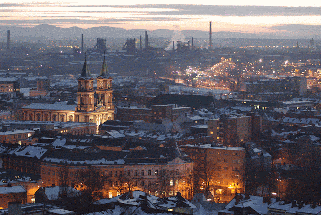
Ostrava is the third largest city in the Czech Republic and the second largest urban agglomeration after Prague. Located close to the Polish border, it is also the administrative center of the Moravian-Silesian Region. Ostrava was candidate for the title of European Capital of Culture 2015. Ostrava is located at the confluence of the Ostravice, Oder, Lučina and Opava rivers. Its history and growth have been largely affected by exploitation and further use of the high quality black coal deposits discovered in the locality, giving the town a look of an industrial city and a nickname of the “steel heart of the republic” during the communist era of Czechoslovakia.

Ostrava was an important crossroads of prehistoric trading routes, namely the Amber Road. Archaeological finds have proved that the area around Ostrava has been permanently inhabited for 25,000 years. Circa 23,000 BC, the Venus of Petřkovice from Petřkovice in Ostrava, Czech Republic, was made. It is now in Archeological Institute, Brno. In the 13th century, the Ostravice river marked the border between the Silesian duchy of Opole and the March of Moravia under Bohemian suzerainty. Two settlements arose on both sides of the river: Slezská Ostrava (Silesian Ostrava) was first mentioned in 1229, Moravská Ostrava (Moravian Ostrava) in 1267, it received town privileges in 1279. The Piast dukes of Opole in 1297 built a fortress on their side of the river. Both parts were largely settled by Germans in the course of the Ostsiedlung.
Until the late 18th century, Moravská Ostrava was a small provincial town with a population around one thousand inhabitants engaged in handicraft. In 1763, large deposits of black coal were discovered, leading to an industrial boom and a flood of new immigrants in the following centuries. During the 19th century, several mine towers were raised in and around the city and the first steel works were established at Vítkovice, acquired by Salomon Mayer von Rothschild in 1843. Industrial growth was made possible by the completion of Kaiser-Ferdinands-Nordbahn from Vienna in 1847. The 20th century saw further industrial expansion of the city accompanied by an increase in population and the quality of civic services and culture. However, during World War II, Ostrava – as an important source of steel for the arms industry – suffered several massive bombing campaigns that caused extensive damage to the city.
Since the Velvet revolution in 1989 the city has been going through major changes. A thorough restructuring of industry is taking place – coal mining in the area of the city was stopped in 1994 and a large part of the Vítkovice ironworks near the city center was closed down in 1998.

The development in university education, especially in humanities, significantly contributed to the recovery of cultural life in Ostrava after 1990. The need for mutual meetings, discussions and presentations of the first literary, artistic and musical attempts led to the creation of the cult club Black Spider (Černý pavouk). It quickly became a popular place for young Ostrava artists and intellectuals. Other “competing” clubs were founded nearby shortly afterwards and each of them provides for its own specific atmosphere. Whether you are looking for a little jazz or rock, dance clubs, karaoke, casinos, bowling, billiards, or just a quiet place to have a drink, you’ll find it all on today’ s Stodolní Street. Known around the Czech Republic as the “Street that Never Sleeps”, Stodolní’s reputation is growing all over Europe.

Ostrava’s Top 5:
- The Cathedral of The Divine Saviour. The second largest cathedral in Moravia and Silesia (after the basilica in Velehrad) is one of the most beautiful churches in the city. The three-aisled Neo-Renaissance basilica is completed with a semicircle apse with two 67m-high towers from 1889 (according to a project by Gustav Merett). The interior is the work of Max von Ferstel. Pope John Paul II founded the Ostrava-Opava diocese in May 1996, and in September of the same year, the basilica was upgraded to a cathedral. Since 1998, it has been equipped with a Neo-Baroque organ. It is often used as a venue for concerts, enhancing the musical experience with its acoustics and atmosphere.
- Silesian Ostrava Castle is a castle in Ostrava. It was originally built in the 1280s near the confluence of the Lučina and Ostravice rivers. The castle was built for military purposes due to its proximity to the Polish border. In 1534, the gothic castle was rebuilt into a renaissance chateau. It burned down in 1872 but was rebuilt. It was restored recently after many years of dilapidation, caused by coal mining under the castle. Today, the castle is one of the most important tourist attraction of the city.
The castle held the Colours of Ostrava festival in 2007. - The Viewing Tower of the New City Hall The Viewing Tower is one of the city's most popular tourist attractions. On a clear day, it is possible to see the entire city, the nearby Beskydy Mountains, and even neighbouring Poland. The Viewing Tower has dominated the Ostrava skyline since it was built at the New City Hall (the largest in the Czech Republic) in 1930. The strict functionalist style of the tower creates, in the opinion of its designers, a noble beacon of concrete, metal and glass. The tower reaches 298.05 metres above sea level, or roughly 85.60 metres above ground level. The tower is equipped with an illuminated clock face, an elevator, and a lookout deck 72 metres above the ground. The Ostrava City Information Centre, located directly beneath the tower, provides all sorts of information about the city, in several languages.
- Antonín Dvořák Theatre in Ostrava is one of the opera houses in the Czech Republic. It is a part of the National Moravian Silesian Theatre, founded in 1918. The
Neo-baroque building of the theatre was designed by architect Alexander Graf, realisation was made by Ostrava company Noe & Storch. Antonín Dvořák Theatre was the first building in Czechoslovakia using reinforced concrete beams. The interior was designed by sculptors of the Johann Bock & son company. The sculptures decorating the facade made Eduard Smetana and Leopold Kosiga. Drama and Music, two reliefs in the main foyer of the theatre, were donated by academic sculptor Helena Scholzová alias Helen Zelezny-Scholz. Antonín Dvořák Theatre was opened on 28 September, 1907, as German theatre. Up to 1919, the performances were solely German. Following the World War I, the theatre passed to the hands of Czechoslovak state and became a stage of the National Moravian Silesian Theatre. From 1949, the theatre was renamed to Zdeněk Nejedlý Theatre and in 1990 to Antonín Dvořák Theatre. - The Ostrava museum was established by merging three older local museums in the Old Post-Office building after World War One. Since 1931 it occupies the Old Town Hall in Masaryk Square, the oldest existing example of original historic architecture typical of Ostrava's city core. On display are local history of Ostrava and a couple of other theme shows. Its singular feature and pride item is the 225 cm (88.58 in) tall indoor astronomical clock called the Mašek Clock. It boasts 51 different functional features and consists of four dials: clock, calender, astronomical and planetary dials.

 |
| Silesian Ostrava Castle |
References: http://www.ostrava.cz/en
Oulu

Oulu is a city and municipality in the region of Northern Ostrobothnia, in Finland. It is the most populous city in Northern Finland and the sixth most populous city in the country. It is one of the northernmost larger cities in the world.

Oulu was founded on April 8, 1605, by King Charles IX of Sweden opposite to the fort built on the island of Linnansaari. This took place after favourable peace settlements with the Russians, which removed the threat of attack via the main east-west waterway, the river Oulu. The surrounding areas were populated much earlier. Oulu is situated by the Gulf of Bothnia, at the mouth of river Oulujoki, which is an ancient trading site. One possible source for the name Oulu is a word in the Sami language meaning 'flood water', but there are other suggestions. Oulu was the capital of the Province of Oulu from 1776 to 2009.
In 1822, a major fire destroyed much of the city. The architect Carl Ludvig Engel, chiefly known for the neoclassical (empire style) buildings around Helsinki Senate Square, was enlisted to provide the plan for the rebuilding of the city. With minor changes, this plan remains the basis for the layout of Oulu's town center. The Oulu Cathedral was built in 1832 to his designs, with the spire being finished in 1844.
Once known for wood tar and salmon, Oulu has evolved into a major high-tech centre, particularly in IT and wellness technology. Other prominent industries include wood refining, paper, and steel. The University of Oulu is located six kilometres north of the city center. The Oulu Airport, located in the neighboring municipality of Oulunsalo, is the second busiest in Finland.

The municipality of Ylikiiminki was merged with the city of Oulu on January 1, 2009. Oulu and the municipalities of Haukipudas, Kiiminki, Oulunsalo and Yli-Ii will be merged on January 1, 2013.
Oulu, somewhat surprisingly, is a place for eating pizza. For as low as €4-7 you can get a pizza with your choice of (usually three) toppings. Also there are many restaurants that have a pizza buffet for around €7-12 which includes a drink. Arguably, Finland's biggest pizzas are served in Oulu's Pizzeria Romeo. There is also the Pannu pizza joint in town - a bit more up-market pizzas for the discerning.
During the summer months, head down to the marketplace and have some fried vendace (muikku) or salmon in one of the stands there. A number of restaurants serving international cuisine or fast food are found in Oulu, including Indian, Greek, Mediterranean, Russian, Spanish, Turkish, Thai and Chinese kitchens. For American style fast food there is McDonald's, Hesburger and Movie Diner which is decorated in the style of a 50's American diner.
An interesting little restaurant is Pannukakkutalo Renesans near the market square, serving dutch style pannekoeken, or for the unfamiliar, crêpes. More than a hundred of either sweet or savory toppings to choose from.

For finnish cuisine, head over the pedestrian bridge from the library to Pikisaari for Ravintola Sokeri-Jussi, offering traditional courses like Rössypottu (potatoes, blood and pork). Good experiences in a bit more upscale dining would be either Uleåborg or Puistola Dining, for a bit more affordable but still nice dining head near the Oulu Cathedral to Ravintola Hella.
Ravintola Toripolliisi offers gastropub-style fare in nice surroundings both inside and outside, just in the corner of the marketplace. During the lunch time, usually from 11am to 15pm, most restaurants serve food at reasonable prices.
Ravintola Toripolliisi offers gastropub-style fare in nice surroundings both inside and outside, just in the corner of the marketplace. During the lunch time, usually from 11am to 15pm, most restaurants serve food at reasonable prices.
Oulu’s Top 5:
- The Oulu Cathedral is an Evangelical Lutheran cathedral and the seat of the Diocese of Oulu. The church was built in 1777 as a tribute to the King of Sweden Gustav III of Sweden and named after his wife as Sofia Magdalena's church. The wooden structures burned in the large fire of the city of Oulu in 1822. The church was built again on top of the old stonewalls with famous architect Carl Ludvig Engel as the designer. The restoration works were completed in 1832, but the belfry was not erected until 1845.
- Tietomaa. The best way to keep one’s mind alert throughout your life is to constantly strive to learn more. An exceptional place for discovering new things is the Tiedekeskus Tietomaa. Theme exhibitions along with over 150 objects guarantee that you’ll have things to see and experience for the whole day. The giant movie theatre will capture audiences, along with the Sirius science store, Saturnus café-restaurant, and the observation tower, accessible by a glass elevator
- Observatory Café. By the bridges of Tuira, you can visit the remains of Oulu Castle, rebuilt in 1605 by decree of Sweden’s King Carl IX. In 1875, the Oulu Marine Institute’s Observatory was built on the rock base of the castle. These days the place is where the Observatory summer café stands. The basement holds a small exhibition about the castle’s history, produced by the Northern Ostrobothnia Museum.
- The Northern Ostrobothnia museum is a museum of cultural history. This provincial museum focuses on the city of Oulu and its the surrounding province Northern Ostrobothnia. The museum was founded in 1896 and it was maintained by a museum society until 1969, when the ownership was handed over to the city of Oulu. Between the years 1911–1929 the museum operated in an old wooden villa Villa Ainola, which was destroyed in a fire on July 9th, 1929. Some of the collections of the museum were also destroyed. Soon after the fire the current museum building was started to be built on the site of the old villa. The new stone house was completed in 1931. The building was designed by a Finnish architect Oiva Kallio. Oulu City Library was also located in the building until 1982.
- Turkansaari is an island in Oulujoki river with an open air museum in the Madekoski neighbourhood. The museum is run by Northern Ostrobothnia museum. Turkansaari island has been an ancient market place for Russian traders in Oulujoki river. The open-air museum was started out when the old church, from the year 1694, was restored on the island in 1922. Every summer there is a tar kiln lit to produce tar in the traditional way.


No comments:
Post a Comment