Translate

Monday, 22 October 2012

Toulon

Toulon


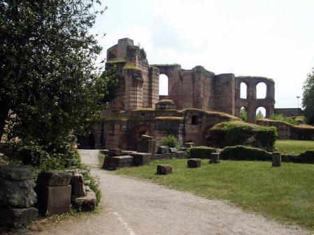
Toulon is a city in southern France and a large military harbor on the Mediterranean coast, with a major French naval base. Located in the Provence-Alpes-Côte-d'Azur region, Toulon is the capital of the Var department in the former province of Provence. 

Toulon is an important centre for naval construction, fishing, wine making, and the manufacture of aeronautical equipment, armaments, maps, paper, tobacco, printing, shoes, and electronic equipment.

Archaeological excavations, such as those at the Cosquer Cave near Marseilles, show that the coast of Provence was inhabited since at least the Paleolithic era. Greek colonists came from Asia Minor in about the 7th century BC and established trading depots along the coast, including one, called Olbia, at Saint-Pierre de l'Almanarre south of Hyères, to the east of Toulon. The Ligurians settled in the area beginning in the 4th century BC.

In the 2nd century BC, the residents of Massalia (present-day Marseilles) called upon the Romans to help them pacify the region. The Romans defeated the Ligurians and began to start their own colonies along the coast. A Roman settlement was founded at the present location of Toulon, with the name Telo Martius – Telo, either for the goddess of springs or from the Latin tol, the base of the hill – and Martius, for the god of war. Telo Martius became one of the two principal Roman dye manufacturing centres, producing the purple colour used in imperial robes, made from the local sea snail called murex, and from the acorns of the oak trees. Toulon harbour became a shelter for trading ships, and the name of the town gradually changed from Telo to Tholon, Tolon, and Toulon.


Toulon was Christianized in the 5th century, and the first cathedral built. Honoratus and Gratianus of Toulon (Gratien), according to the Gallia Christiana, were the first bishops of Toulon, but Louis Duchesne gives Augustalis as the first historical bishop. He assisted at councils in 441 and 442 and signed in 449 and 450 the letters addressed to Pope Leo I from the province of Arles.

A Saint Cyprian, disciple and biographer of St. Cæsarius of Arles, is also mentioned as a Bishop of Toulon. His episcopate, begun in 524, had not come to an end in 541; he converted to Catholicism two Visigothic chiefs, Mandrier and Flavian, who became anchorites and martyrs on the peninsula of Mandrier. In 1095, a new cathedral was built in the city by Gilbert, Count of Provence. As barbarians invaded the region and Roman power crumbled, the town was frequently attacked by pirates and the Saracens.

In 1486 Provence became part of France. Soon afterwards, in 1494, Charles VIII of France, with the intention of making France a sea power on the Mediterranean, and to support his military campaign in Italy, began constructing a military port on the rade of Toulon. His Italian campaign failed, and 1497, the rulers of Genoa, who controlled commerce on that part of the Mediterranean, blockaded the new port.

In 1524, as part of his longtime battle against Emperor Charles V and the Holy Roman Empire, King Francis I of France completed a powerful new fort, the Tour Royale, Toulon, at the entrance of the harbour. However, a few months later the commander of the new fort sold it to the commander of an Army of the Holy Roman Empire, and Toulon surrendered.

Tour Royale
In 1543, Francis I found a surprising new ally in his battle against the Holy Roman Empire. He invited the fleet of Ottoman Admiral Barbarossa to Toulon as part of the Franco-Ottoman alliance. The residents were forced to leave, and the Ottoman sailors occupied the town for the winter.

King Louis XIV was determined to make France a major sea power. In 1660, his Minister Jean-Baptiste Colbert ordered Sébastien Le Prestre de Vauban to build a new arsenal and to fortify the town. In 1707, during the War of the Spanish Succession, Toulon successfully resisted a siege by the Imperial Army led by the Duke of Savoy and Prince Eugene. However in 1720, the city was ravaged by the black plague, coming from Marseilles. Thirteen thousand people, or half the population, died.

In 1790, following the French Revolution, Toulon became the administrative centre of the département of the Var. The leaders of the city, however, were largely royalists, and they welcomed the arrival of a British fleet. At the siege of Toulon, the British were expelled by a French force whose artillery was led by a young captain, Napoleon Bonaparte. To punish Toulon for its rebellion, the town lost its status as department capital and was briefly renamed Port-la-Montagne.

During the Napoleonic Wars, from 1803 until 1805 a British fleet led by Admiral Horatio Nelson blockaded Toulon.

In 1820, the statue which became known as the Venus de Milo was discovered on the Greek island of Milo and seen by a French naval officer, Emile Voutier. He persuaded the French Ambassador to Turkey to buy it, and brought it to Toulon on his ship, the Estafette. From Toulon it was taken to the Louvre.

In 1820 Toulon became the base for the conquest of France's colonies in North Africa. In 1820 a French fleet with an army departed from Toulon for the conquest of Algeria.

1849, during the brief Second French Republic, Baron Haussmann was named Prefect of the Var. During his year as prefect, he began a major reconstruction of the city, similar to what he would later do in Paris. He tore down large parts of the old fortifications and built new boulevards and squares. The new Toulon Opera House, the second-largest in France, opened in 1862.

In 1867, on the orders of Napoleon III General François Achille Bazaine arrived in Toulon without an official welcome after abandoning the Mexican military campaign and Emperor Maximilian I of Mexico.


During World War II, after the Allied landings in North Africa (Operation Torch) the German Army occupied southern France (Case Anton), leading to the scuttling of the French Fleet at Toulon (27 November 1942). The city was bombed by the Allies in November of the following year, with much of the port destroyed and five hundred residents killed. Toulon was captured by the Free French Forces of General Jean de Lattre de Tassigny on 28 August 1944.

In 1974 Toulon became again the préfecture, or administrative centre, of the Var. Five years later the University of Toulon (University of the South, Toulon-Var) opened. Toulon was one of four French cities where the extreme-right Front National won the local elections in 1995. The Front National was voted out of power in 2001.


                                                        Toulon’s Top 5:
       
  1. Toulon Cathedral  is a Roman Catholic cathedral and a national monument of France, begun in the 11th century and finished in the 18th century. From the 5th century onwards it was the seat of the Bishops of Toulon, and since 1957 has been the seat of the Bishops of Fréjus-Toulon. The Classical façade was created in 1696–1701, in the reign of Louis XIV. Angels on the tympanum of the massive porch, supported on Corinthian columns, hold the arms of Toulon. The façade was badly damaged in the French Revolution, but was restored to its original appearance in 1816. It also displays a memorial plaque from 1239, dedicated to Gilbert of Baux, who died in 1239, and to Gaufridet of Trets and Toulon, and his wife Dame Guillaumette, both of whom died in 1234. The clock tower was built between 1737 and 1740, the same time as the monumental gate of the Toulon Arsenal. It is 36 meters high, and three meters thick at the base. On top of the tower is an iron campanile, where a bell has kept time in Toulon since 1524. The original bells were taken and melted down during the French Revolution. In 1806 and 1807 they were replaced by four new bells.
  2. The Tour Royale (also known as La Grosse Tour) is a fort built in the 16th century to protect the entrance of the Petit Rade, the naval port of Toulon. It was the first fortification of the harbor, built 22 years after Provence became a part of France. The fort was commissioned in 1513 by King Louis XII at the request of the bishop of Toulon and of the Senechal of Provence. It was placed on the cap de la Manegue, at the end of the pointe de la Mitre, where it could fire at any ships coming into the Rade. The design was by the Italian engineer Gian-Antonio della Porta. It was a classical example of a Torrioni, a round tower with cannon, constructed around Renaissance Italy in the 16th century. The tower was sixty meters in diameter and seven meters thick. Construction began in 1514 and was finished in 1524, during the reign of Francis I of France, at a cost of 30,000 florins. Because of its impressive size, the residents of Toulon called "La Grosse Tour."
  3. The Toulon Opera (L'opéra de Toulon), inaugurated in 1862, is the second-largest opera house in France, after the Palais Garnier in Paris, and it is one of the country's national historic monuments. It is currently the home of the Opéra Toulon Provence Méditerranée, under the direction of Claude-Henri Bonnet. The house seats 1,797 people on five levels. The theatre sits on 2,000 square meters of foundation and has a stage width of 22 meters 80 centimeters and a depth of 12 metres (39 ft). The permanent opera staff consists of over 200 people.
  4. The Museum of the French Navy (Musée national de la marine) is located on Place Monsenergue, next on the west side of the old port, a short distance from the Hotel de Ville. The Museum was founded in 1814, during the reign of the Emperor Napoleon. It is located today behind what was formerly the monumental gate to the Arsenal of Toulon, built in 1738. The building of the museum, along with the clock tower next to it, is one of the few buildings of the port and arsenal which survived Allied bombardments during World War II. It contains displays tracing the history of Toulon as a port of the French Navy. Highlights include large 18th century ship models used to teach seamanship, models of the aircraft carrier Charles De Gaulle.
  5. Mount Faron (584 metres) dominates the city of Toulon. The top can be reached either by a cable car from Toulon, or by a narrow and terrifying road which ascends from the west side and descends on the east side. The road is one of the most challenging stages of the annual Paris–Nice and Tour Méditerranéen bicycle races.
    At the top of Mount Faron is a memorial dedicated to the 1944 Allied landings in Provence (Operation Dragoon), and to the liberation of Toulon.


Thursday, 18 October 2012

Tours

Tours


Tours is a city in central France, the capital of the Indre-et-Loire department.

It stands on the lower reaches of the river Loire, between Orléans and the Atlantic coast. Touraine, the region around Tours, is known for its wines, the alleged perfection (as perceived by some speakers) of its local spoken French, and the Battle of Tours in 732. It is also the site of the Paris–Tours road bicycle race. Tours is the largest city in the Centre region of France, although it is not the regional capital, which is the region's second-largest city, Orléans.

In Gallic times the city was important as a crossing point of the Loire. Becoming part of the Roman Empire during the first century AD, the city was named "Caesarodunum" ("hill of Caesar"). The name evolved in the 4th century when the original Gallic name, Turones, became first "Civitas Turonum" then "Tours". It was at this time that the amphitheatre of Tours, one of the five largest in the Empire, was built. Tours became the metropolis of the Roman province of Lugdunum towards 380–388, dominating the Loire Valley, Maine and Brittany. One of the outstanding figures of the history of the city was Saint Martin, second bishop who shared his coat with a naked beggar in Amiens. This incident and the importance of Martin in the medieval Christian West made Tours, and its position on the route of pilgrimage to Santiago de Compostela, a major centre during the Middle Ages.


In the 6th century Gregory of Tours, author of the Ten Books of History, made his mark on the town by restoring the cathedral destroyed by a fire in 561. Saint Martin's monastery benefited from its inception, at the very start of the 6th century from patronage and support from the Frankish king, Clovis, which increased considerably the influence of the saint, the abbey and the city in Gaul. In the 9th century, Tours was at the heart of the Carolingian Rebirth, in particular because of Alcuin abbot of Marmoutier.

In 732 AD, Abdul Rahman Al Ghafiqi and a large army of Muslim horsemen from Al-Andalus advanced 500 km deep into France, and were stopped at Tours by Charles Martel and his infantry igniting the Battle of Tours. The outcome was defeat for the Muslims, preventing France from Islamic conquest. In 845, Tours repulsed the first attack of the Viking chief Hasting (Haesten). In 850, the Vikings settled at the mouths of the Seine and the Loire. Still led by Hasting, they went up the Loire again in 852 and sacked Angers, Tours and the abbey of Marmoutier.

During the Middle Ages, Tours consisted of two juxtaposed and competing centres. The "City" in the east, successor of the late Roman 'castrum', was composed of the archiepiscopal establishment (the cathedral and palace of the archbishops) and of the castle of Tours, seat of the authority of the Counts of Tours (later Counts of Anjou) and of the King of France. In the west, the "new city" structured around the Abbey of Saint Martin was freed from the control of the City during the 10th century (an enclosure was built towards 918) and became "Châteauneuf". This space, organized between Saint Martin and the Loire, became the economic centre of Tours. Between these two centres remained Varenne, vineyards and fields, little occupied except for the Abbaye Saint-Julien established on the banks of the Loire. The two centres were linked during the 14th century. Tours is a good example of a medieval double city.

Tours became the capital of the county of Tours or Touraine, territory bitterly disputed between the counts of Blois and Anjou – the latter were victorious in the 9th century. It was the capital of France at the time of Louis XI, who had settled in the castle of Montils (today the castle of Plessis in La Riche, western suburbs of Tours), Tours and Touraine remained until the 16th century a permanent residence of the kings and court. The rebirth gave Tours and Touraine many private mansions and castles, joined together to some extent under the generic name of the Chateaux of the Loire. It is also at the time of Louis XI that the silk industry was introduced – despite difficulties, the industry still survives to this day.

Charles IX passed through the city at the time of his royal tour of France between 1564 and 1566, accompanied by the Court and various noblemen: his brother the Duke of Anjou, Henri de Navarre, the cardinals of Bourbon and Lorraine. At this time, the Catholics returned to power in Angers: the intendant assumed the right to nominate the aldermen. The Massacre of Saint-Barthelemy was not repeated at Tours. The Protestants were imprisoned by the aldermen – a measure which prevented their extermination. The permanent return of the Court to Paris and then Versailles marked the beginning of a slow but permanent decline. Guillaume the Metayer (1763–1798), known as Rochambeau, the well known counter-revolutionary chief of Mayenne, was shot there on Thermidor 8, year VI.

The city was greatly affected by the First World War. A force of 25,000 American soldiers arrived in 1917, setting up textile factories for the manufacture of uniforms, repair shops for military equipment, munitions dumps, an army post office and an American military hospital at Augustins. Thus Tours became a garrison town with a resident general staff. The American presence is remembered today by the Woodrow Wilson bridge over the Loire, which was officially opened in July 1918 and bears the name of the man who was President of the USA from 1912 to 1920. Three American air force squadrons, including the 492nd, were based at the Parçay-Meslay airfield, their personnel playing an active part in the life of the city. Americans paraded at funerals and award ceremonies for the Croix de Guerre; they also took part in festivals and their YMCA organised shows for the troops. Some men married girls from Tours.

Tours was also marked by the Second World War. In 1940, the city suffered massive destruction and for four years it was a city of military camps and fortifications. From 10–13 June 1940, Tours was the temporary seat of the French government before its move to Bordeaux. German incendiary bombs caused a huge fire which blazed out of control from 20–22 June and destroyed part of the city centre. Some architectural masterpieces of the 16th and 17th centuries were lost, as was the monumental entry to the city. The Wilson Bridge (known locally as the 'stone bridge'), carried a water main which supplied the city; the bridge was dynamited to slow the progress of the German advance. With the water main severed and unable to extinguish the inferno, the inhabitants had no option but to flee to safety. More heavy air raids devastated the area around the railway station in 1944 causing several hundred deaths.

A plan for the rebuilding of the downtown area drawn up by the local architect Camille Lefèvre was adopted even before the end of the war. The plan was for 20 small quadrangular blocks of housing to be arranged around the main road (la rue Nationale), which was widened. This regular layout attempted to echo, yet simplify, the 18th century architecture. Pierre Patout succeeded Lefèvre as the architect in charge of rebuilding in 1945. At one time there was talk of demolishing the southern side of the rue Nationale in order to make it in keeping with the new development.

The recent history of Tours is marked by the personality of Jean Royer, who was Mayor for 36 years and helped to save the old town from demolition by establishing one of the first Conservation Areas. This example of conservation policy would later inspire the Malraux Law for the safeguarding of historic city centres. In the 1970s, Jean Royer also extended the city to the south by diverting the course of the River Cher to create the districts of Rives du Cher and des Fontaines; at the time, this was one of the largest urban developments in Europe. 


                                                       Tours’ Top 5:
       
  1. Saint Gatien's Cathedral is the Roman Catholic cathedral church of the Tours diocese and the metropolitan cathedral of the Tours ecclesiastic province. Saint-Gatien's Cathedral was built between 1170 and 1547. At the time construction began, it was located at the south end of the bridge over the Loire, on the road from Paris to the south-west of France. It has been a classified Monument historique since 1862.
  2. The Basilique de St-Martin  The new Basilique de St-Martin is neo-Byzantine in style and is much smaller than its great medieval predecessor. Next to it stand the only remains of the Romanesque basilica: the Tour de Charlemagne and the western clock tower. The relics and shrine to St. Martin are in the basilica's crypt, the walls of which are carved with hundreds of votive prayers dedicated to the saint. In December 1860, excavations located the site of St. Martin's tomb, of which some fragments were discovered. A new basilica to house these relics was constructed by Mgr Meignan, Archbishop of Tours, from 1886-1924. Martin's tomb is still a place of pilgrimage for the faithful.
  3. The Musée des beaux-arts de Tours is located in the bishop's former palace, near the cathedral St. Gatien, where it has been since 1910. It displays rich and varied collections, including that of painting which is one of the first in France both in quality and the diversity of the works presented. The museum has over 12,000 works but only 1,000 are on show to the public. On the ground floor, the museum has a room especially dedicated to Tours art of the fifteenth and sixteenth centuries. The museum was classified as a monument historique on 27 June 1983.
  4. Pont Wilson. Crossing the River Loire, is the elegant Pont Wilson. Known locally as the pont de pierre (stone bridge), it is an exact replica of the original 18th century bridge which collapsed in a flood in 1978. It had previously been repaired after serious damage in the Second World War. On the opposite bank from Tours city centre are four pavilions arranged in a semi-circle to create a small plaza.
  5. The Château de Tours Built in the 11th century, the building displayed an architecture of the Carolingian period, and was the residence of the Lords of France. Until the 2000s, the Royal Castle of Tours was used as an aquarium where about 1,500 fish of 200 different species could be seen. It also served as Grévin museum. The castle was classified as monument historique on 20 August 1913. Currently, the building houses contemporary exhibitions of paintings and photographs, including works by Joan Miró, Daniel Buren, Nadar, and the workshop of Tours history where archeological and historical documents, models, audio-visual films on the history of Tours, etc., are shown.


Wednesday, 17 October 2012

Turku

Turku


Turku is a city on the southwest coast of Finland at the mouth of the Aura River, in the region of Finland Proper. Turku, as a town, was settled during the 13th century and founded most likely at the end of the 13th century, making it the oldest city in Finland. It quickly became the most important city in Finland, a status it retained for hundreds of years. After Finland became part of the Russian Empire (1809), and the capital of the Grand Duchy of Finland was moved to Helsinki (1812), Turku continued to be the most populous city in Finland, until the end of the 1840s. Today it remains a regional capital and an important business and cultural center.

Because of its long history it has been the site of many important events and has extensively influenced Finnish history. Along with Tallinn, the capital city of Estonia, Turku was designated the European Capital of Culture for 2011. In 1996 it was declared the official Christmas City of Finland.


Due to its location, Turku is a notable commercial and passenger seaport with over three million passengers travelling through the Port of Turku each year to Stockholm and Mariehamn.

Turku has a long history as Finland's largest city and occasionally as the administrative center of the country, but has, over the last two centuries, lost both titles to Helsinki. To this day, the city's identity stems from its status as the oldest city in Finland and the country's first capital. Originally, the word "Finland" referred only to the area around Turku (hence the title, "Finland Proper" for the region).


Although archaeological findings in the area date back to the Stone Age, the town of Turku was founded in late 13th century. The Cathedral of Turku was consecrated in 1300, and together with Turku Castle and the Dominican monastery (founded in 1249), established the city as the most important location in medieval Finland.

During the Middle Ages, Turku was the seat of the Bishop of Turku (a title later upgraded to Archbishop of Turku), covering the then eastern half of the Kingdom of Sweden (most of the present-day Finland) until the 17th century. Even if Turku had no official capital status, both the short-lived institutions of Dukes and Governors-General of Finland usually had their Finnish residences there. In the aftermath of the War against Sigismund, the town was the site of the Åbo bloodbath. In 1640, the first university in Finland, The Royal Academy of Turku, was founded in Turku. Turku was also the meeting place for the States of Finland in 1676.

Turku Castle
After the Finnish War, which ended when Sweden ceded Finland to Imperial Russia at the Treaty of Fredrikshamn in 1809, Turku became briefly the official capital, but soon lost the status to Helsinki, as Emperor Alexander I felt that Turku was too far from Russia and too aligned with Sweden to serve as the capital of the Grand Duchy of Finland. The change officially took place in 1812. The government offices that remained in Turku were finally moved to the new capital after the Great Fire of Turku, which almost completely destroyed the city in 1827. After the fire, a new and safer city plan was drawn up by German architect Carl Ludvig Engel, who had also designed the new capital, Helsinki. Turku remained the largest city in Finland for another twenty years.

In the 20th century Turku was called "Finland's gateway to the West" by historians such as Jarmo Virmavirta. The city enjoyed good connections with other Western European countries and cities, especially since the 1940s with Stockholm across the Gulf of Bothnia. In the 1960s, Turku became the first Western city to sign a twinning agreement with Leningrad in the Soviet Union, leading to greater inter-cultural exchange and providing a new meaning to the city's 'gateway' function. After the fall of Communism in Russia, many prominent Soviets came to Turku to study Western business practices, among them Vladimir Putin, then Leningrad's deputy mayor.

As for architecture in the city, both the body of architectural styles as well as the prevalent way of living have experienced significant changes in the 20th century. While having survived relatively intact throughout the years of war 1939-1945, the city faced increasing changes in the 1950's and 1960's due to rising demands for apartments, the eagerness to rebuild and most of all the new developement of infrastructure (especially increased automobile traffic). The wooden one to two-story houses that were the dominant mode of building in the city were mostly demolished in the 50´s and 60´s to both enable more efficient building and to ease car traffic. Sadly, this resulted in the destruction of most that was in later decades seen as beautiful and worth saving. This was, however, the case in most of the cities in Finland and only a few examples of intact wooden city centres survive to this day (for example Old Rauma). 

Some individual buildings remain controversial to this day when it comes to their demolition in the decades after the war. For example, the building of Hotel Phoenix that stood on corner of Kauppatori was torn down to make way for a large, multistory apartment building in 1959. The building was significant both for its location and history: having stood on one of the most valuable lots in the city centre since 1878 the building had for example served as the first main building of the University of Turku. Other buildings whose demolition was seen as scandalous either already at the time of action or proved to be so in later years include The Nobel House (subject to the very first photograph ever taken in Finland) and the building of Old Hotel Börs (almost directly opposite to Hotel Phoenix, Old Hotel Börs was built in jugendstil in 1909 by Frithiof Strandel).


                                                        Turku’s Top 5:
       
  1. Turku Cathedral is the Mother Church of the Evangelical Lutheran Church of Finland, and the country's national shrine. It is the central church of the Archdiocese of Turku and the seat of the Archbishop of Finland, Kari Mäkinen. It is also regarded as one of the major records of Finnish architectural history. Considered to be the most important religious building in Finland, the cathedral has borne witness to many important events in the nation's history and has become one of the city's most recognizable symbols. The cathedral is situated in the heart of Turku next to the Old Great Square, by the river Aura. Its presence extends beyond the local precinct by having the sound of its bells chiming at noon broadcast on national radio. It is also central to Finland's annual Christmas celebrations. The cathedral was originally built out of wood in the late 13th century, and was dedicated as the main cathedral of Finland in 1300, the seat of the bishop of Turku. It was considerably expanded in the 14th and 15th centuries, mainly using stone as the construction material. The cathedral was badly damaged during the Great Fire of Turku in 1827, and was rebuilt to a great extent afterwards.
  2. Turku Castle is a monument of Finnish history situated in the city of Turku in Finland. Together with Turku Cathedral, the castle is one of the oldest buildings still in use in Finland. Turku Castle is the largest surviving medieval building in Finland. It stands as a national monument, on the banks of the Aura River, as it has done since the 14th century. A start was made on building the castle in about 1280. The Swedish conquerors of Finland intended it originally as a military fortress. During the next two centuries its defences were strengthened and living quarters were added. The castle served as a bastion and administrative centre in Eastland, as Finland was then known, during the Swedish period. The main part of the castle was extended considerably during the 16th century after Gustav Vasa had ascended the Swedish throne and his son John headed the Finnish administration following his promotion to duke. The bailey was also supplemented and the round tower at the southeast corner of the bailey was added. Since then no part of the castle has been added or extended, only repaired.
  3. Aboa Vetus and Ars Nova is a museum in central Turku. The museum is housed in a building known as the Rettig palace, originally built in 1928. Aboa Vetus displays portions of the city dating back to medieval times, while Ars Nova is a museum of contemporary art. The museum was first opened in 1995 as two independent museums. Originally, plans were for only Ars Nova, the contemporary art museum, but during its construction a number of structures and artifacts dating back to the Middle Ages were discovered, and the archaeological excavation that was commissioned eventually transformed into Aboa Vetus. The two museums were combined in 2004 and Aboa Vetus & Ars Nova is now among the most popular tourist venues in the entire region of Finland Proper.
  4. Turku Orthodox Church or the Church of the Holy Martyr Empress Alexandra is the main church of the Turku orthodox parish located on the northeast corner of Turku Market Square. The church was built in under plans drafted by architect Carl Ludvig Engel and was ordered by Nicholas I of Russia on 5 January 1838. Construction, which began in 1839, cost 67,886 rubles and was completed in 1845. The church was consecrated on 2 September 1845. The church was dedicated to Alexandra, the spouse of Diocletian who had publicly became Christianised and suffered a martyr’s death on 23 April 303. Making her the patron saint may have been because of Nicholas I’s own wife’s name Aleksandra Feodorovna.
  5. Luostarinmäki Handicrafts Museum  is an open air museum consisting of 18 blocks of original 18th century – early 19th century buildings on their original location. The area of the museum was the only old residential area left in 1940, when the museum was opened. The location was the largest area to completely survive the Great Fire of Turku. Contemporary handicraft items are presented. The museum received the Golden Apple international tourism award as the only site in Scandinavia in 1984.


Monday, 15 October 2012

Toulouse

Toulouse


Toulouse is a city in the Haute-Garonne department in southwestern France. It lies on the banks of the River Garonne, halfway between the Atlantic Ocean and the Mediterranean Sea, and 590 km (366 mi) away from Paris. The city of Toulouse can be traced back to ancient times. It was the capital of the County of Toulouse in the Middle Ages and today is the capital of the Midi-Pyrénées region.

Archaeological evidence dates human settlement in Toulouse to the 8th century BC. The location was very advantageous, at a place where the Garonne River bends westward toward the Atlantic Ocean and can be crossed easily. It was a focal point for trade between the Pyrenees, the Mediterranean and the Atlantic Immediately north of these hills was a large plain suitable for agriculture. People gathered on the hills overlooking the river, south of the plain, 9 kilometers south of today's downtown Toulouse. The name of the city was Tolosa. Researchers today agree that the name is probably Aquitanian, related to the old Basque language, but the meaning is unknown.

The first inhabitants seem to have been Aquitanians, of whom little is known. Later came Iberians from the south, who, like the Aquitanians, were non-Indo-European people. In the 3rd century BC there came a Celtic Gallic tribe called the Volcae Tectosages from Belgium or southern Germany, the first Indo-European people to appear in the region. They settled in Tolosa and interbred with the local people. Their Gaulish language became predominant. By 200 BC Tolosa is attested to be the capital of the Volcae Tectosages, which C. Julius Caesar later called Tolosates in his famous account of Gallic wars, singular Tolosas. Archeologists say Tolosa was one of the most important cities in Gaul, and certainly it was famed in pre-Roman times for being the wealthiest one. There were many gold and silver mines nearby, and the offerings to the holy shrines and temples in Tolosa had accumulated a tremendous wealth in the city.

The Romans started their conquest of southern Gaul (later known as the Provincia) in 125 BC. Moving westward, they founded in 118 BC the colony of Narbo Martius (Narbonne), the Mediterranean city nearest to inland Toulouse, and so they came into contact with the Tolosates, famous for their wealth and the key position of their capital for trade with the Atlantic. Tolosa chose to ally with the daunting Romans, who established a military fort in the plain north of the city, a key position near the border of independent Aquitania, but otherwise left the inhabitants of Tolosa free to rule themselves in semi-independence.

Tolosa was then fully incorporated into the Roman Provincia (Provincia Romana—the usual name for what was officially called the province of Transalpine Gaul, with its capital at Narbo Martius). Tolosa was an important military garrison at the western border of the Roman realm. However the city remained a backwater in the Provincia, people were still living in the old Celtic city in the hills. No Roman colony was established; few Roman soldiers settled in the area.

The Basilica of St. Sernin


Things changed after the conquest of the rest of Gaul by Julius Caesar. In a sign that Romanization of the people was already well under its way, Tolosa did not take part in the various uprisings against Rome during the Gallic wars. In fact southern France would prove to be the most romanized part of France after the fall of the Roman Empire. Caesar established his camp in the plain of Tolosa in 52 BC, and from there he conquered the western regions of Aquitania. With the conquest of Aquitania and the whole of Gaul, Tolosa was no more a military outpost. It capitalized on its key position for trade between the Mediterranean and the Atlantic, now both under Roman control, and the city developed rapidly.

At the beginning of the 8th century, the Arabs appeared in the region. Coming from Spain along the Mediterranean coast they captured Narbonne from the last Visigoths in 719. Then al-Samh ibn Malik al-Khawlani, the wali (governor) of al-Andalus (Muslim Spain), mustered a strong army (from North Africa, Syria, and Yemen) and set to conquer Aquitaine. 

Moving west from Narbonne he besieged Toulouse, capital of the duchy of Aquitaine, but after 3 months of siege, just as the city was about to surrender, Duke Odo of Aquitaine (also known as Eudes) who had left the city to find help managed to come back with an army and defeated the Arab army at the Battle of Toulouse on June 9, 721, just outside of the city walls. Noticeably, the Frankish Charles Martel had refused to help, wishing to take advantage of the situation to recover Aquitaine, and Odo is recorded as leading an army of ('Roman' and maybe Basque speaking Gascon) Aquitanians and regional Franks to fight against the Arabs. 

The Battle of Toulouse was a crushing defeat for the Arabs, who perished in battle by the thousands. The Arab army scattered and most of the soldiers were killed, al-Samh died of his wounds, and the remainder of the Arab troops under second-in-command Abd al-Rahman al-Ghafiqi fled back to Narbonne where Duke Odo decided not to pursue them. This battle is still remembered today among Arab historians as the major check in Arab expansions toward the west.
The French Revolution is a major event in the Toulouse history. It changed the role of the city, as well as its political and social structure.

The city was one of many spectators of the Parisian movement. The on-coming of the protests of July 14, 1789 had minor repercussions, punctuated by some plundering. Five months later, when the Ancien Régime was abolished, a new order took over. The members of the Parlement and the Capitouls fought to preserve their privileges, they demonstrated on September 25, and hardly received any support from a population which did not recognize its former protectors.

The regional influence of Toulouse, formerly ensured by its Parlement, was reduced to a department, Haute-Garonne. The clergy was required to yield to the "Civil Constitution of the Clergy" imposed by the constituent assembly. A new archbishop was named despite the disagreement of Loménie de Brienne. Part of the population was hostile to these reforms and their financial impact.

The prerogatives of the Capitouls were abolished on December 14, 1789. Joseph de Rigaud was the first mayor, elected on February 28, 1790.

In 1793, during the Commune, Toulouse refused to join the Provence and Aquitaine federalists in going to Paris. The prospects of the war against Austria and those of the interior resistance's initiated the Terror, purifying Toulouse from part of the refractors to the Revolution.

In 1799, the fortified city resisted the attack of the British and Spanish royalist armies, during the first battle of Toulouse. The elevation of Napoleon to the head of the new regime, then empire, restored partially the regional statute of the city. The emperor even came to Toulouse in 1808, and gave in particular the Daurade cloister to the tobacco factory.

In 1814, during the battle of Toulouse, the British army entered the city abandoned by the imperial army. Hence 10 April 1814 marks the last battle of the Empire: Napoleon having abdicated eight days earlier (but unfortunately the French commander, Soult, hadn't yet been informed!) The army of Wellington was welcomed there by a great number of royalists, which prepared Toulouse for the Restoration of Louis XVIII.

                                                        Toulouse’s Top 5:
       
  1. Toulouse Cathedral (Cathédrale Saint-Étienne de Toulouse) is a Roman Catholic cathedral, and a national monument of France. It is the seat of the Archbishop of Toulouse. The exact date of the original building is unknown; the first mention of a church building on that site is found in a charter of 844. In 1073 the bishop of Toulouse commenced work on a more elaborate structure, followed by additional construction in the 13th century. The irregular west front exists because the cathedral consists of two incomplete churches, the first dating from the early 13th century, which includes the rose window from 1230; and the other begun in about 1272, on a new plan and a different axis, which was later abandoned, although by 1445 a triforium had been added to the choir and a Flamboyant west portal had been inserted. It is off-center because the architect took care to save the baptismal chapel north of the entrance. An oblong tower, composed of a Gothic portion on Romanesque foundations, and capped by a 16th-century gable belfry, completed the west façade. Also in the 15th century the nave and choir vaults were unsymmetrically connected, while in 1609, after a fire, the choir vault was rebuilt. It was not until the 1920s that its north wall was cleared of abutting buildings and a doorway added, similar in style to the west entrance.
  2. The Basilica of St. Sernin is the former abbey church of the Abbey of St. Sernin or St. Saturnin. It was built in the Romanesque style between about 1080 and 1120. It is located on the site of a previous basilica of the 4th century which contained the body of Saint Saturnin or Sernin, the first bishop of Toulouse in c. 250. The basilica was added to the UNESCO World Heritage Sites under the description: World Heritage Sites of the Routes of Santiago de Compostela in France since 1998.
  3. The Pont Neuf, French for "New Bridge" (a.k.a. Pont de Pierre and Grand Pont), is a 16th century bridge in Toulouse. Original planning for the bridge started in 1542 by the assembly of a committee of master masons and carpenters. Construction started on the foundations in 1544; the first arch was started in 1614. The bridge was finished in 1632, and was inaugurated on 19 October 1659. The bridge is not symmetrical; the longest arch is the third from the right-hand bank. The openings through the piers were originally supposed to represent the face and mane of a lion. A triumphal archway added in 1686 constricted traffic and was removed in 1860.
  4. The Musée des Augustins de Toulouse is a fine arts museum which conserves a collection of sculpture and paintings from the Middle Ages to the early 20th century. The paintings are from throughout France, the sculptures representing Occitan culture of the region with a particularly rich assemblage of Romanesque sculpture.
  5. The Capitole de Toulouse is the heart of the municipal administration of the French city of Toulouse. The Capitouls (governing magistrates) of the Toulouse embarked on the construction of the original building in 1190, to provide a seat for the government of a province growing in wealth and influence. The name "Capitole" referred not only to the Roman Capitol but also to the capitulum which was the chapter of the governing magistrates. In the 20th century, the structures surrounding the vast (2 hectares) Place du Capitole were redesigned. Some of the interior of the Capitole can be traced back to the 16th century, but the current façade, 135 metres long and built of the characteristic pink brick in Neoclassical style, dates from 1750, built according to plans by Guillaume Cammas. The eight columns represent the original eight capitouls. In 1873, Eugène Viollet-le-Duc built a bell tower typical of the style of northern France on top of the donjon of the building. It was in this donjon that Jean Calas, a Protestant victim of a religiously biased trial, was interrogated. Only the Henri IV courtyard and gate survive from the original medieval buildings. It was in this courtyard that the Duke de Montmorency was decapitated after his rebellion against Cardinal Richelieu.


Hertz

Friday, 12 October 2012

Trier

Trier


Trier, historically called in English Treves, is a city in Germany on the banks of the Moselle. It is the oldest city in Germany, founded in or before 16 BC. Trier lies in a valley between low vine-covered hills of ruddy sandstone in the west of the state of Rhineland-Palatinate, near the border with Luxembourg and within the important Mosel wine region.

The city is the oldest seat of a Christian bishop north of the Alps. In the Middle Ages, the Archbishop of Trier was an important prince of the church, as the Archbishopric of Trier controlled land from the French border to the Rhine. The Archbishop also had great significance as one of the seven electors of the Holy Roman Empire.


According to the legendarium recorded in the 12th-century Gesta Treverorum, the city was founded by an eponymous otherwise unrecorded Trebeta, an Assyrian prince, placing the city's founding legend centuries before and independently of ancient Rome: a medieval inscription on the facade of the Red House in Trier market,

ANTE ROMAM TREVIRIS STETIT ANNIS MILLE TRECENTIS.PERSTET ET ÆTERNA 
PACE FRVATVR. AMEN.

"Thirteen hundred years before Rome, Trier stood / may it stand on and enjoy eternal peace, amen," reflects the proud city tradition. Further embroidery in the monkish Gesta made of Trebeta the son of Ninus, a "King of Assyria" imagined by the ancient Greeks, by a wife prior to his marriage to the equally non-historical Queen Semiramis. His stepmother, Semiramis, despised him and when she took over the kingdom after the death of his father, Ninus, Trebeta left Assyria and went to Europe. After wandering for a time, he led a group of colonizers to the site of Trier. Upon his death, his body was cremated on Petrisberg by the people of Trier. The image of "Trebeta" became an icon of the city during the Middle Ages.

In historical time, the Roman Empire subdued the Treveri in the 1st century BC and established Augusta Treverorum (Lit: August (Regal, noble) [City] of the Treveri) in 30 BC. The name is likely to be taken from the title Augustus held by the Princeps or head of state at the time, Augustus Caesar. The city later became the capital of the Roman province of Gallia Belgica, as well as the Roman prefecture of Gaul. It covered 282 ha within its walls and may have had as many as 70,000 inhabitants. The Porta Nigra is counted among the Roman architecture of the city. A residence of the Western Roman Emperor, Roman Trier was the birthplace of Saint Ambrose. Sometime between 395 and 418 the Roman administration moved the staff of Pretorian Prefecture from the city to Arles. The city continued to be inhabited, but was not as prosperous as before, because of the absence of 2,000 staff members of the Prefecture and military. However, the city remained the seat of a governor and had state factories for the production of ballistae and armor, and a wool mill for uniforms for the troops, clothing for the civil service and high-quality garments for the Court. Northern Gaul was held by the Romans along a line from north of Cologne to the coast at Boulogne through what is today southern Belgium until 460. South of this line, Roman control was firm, as evidenced by the continuing operation of the imperial arms factory at Amiens.

The Franks seized Trier from Roman administration in 459 AD. In 870, it became part of Eastern Francia, which developed into the Holy Roman Empire. Relics of Saint Matthias brought to the city initiated widespread pilgrimages. The bishops of the city grew increasingly powerful and the Archbishopric of Trier was recognized as an electorate of the empire, one of the most powerful states of Germany. The University of Trier was founded in the city in 1473.

In the 17th century, the Archbishops and Prince-Electors of Trier relocated their residences to Philippsburg Castle in Ehrenbreitstein, near Koblenz. A session of the Reichstag was held in Trier in 1512, during which the demarcation of the Imperial Circles was definitively established.

In the 17th and 18th centuries, Trier was sought after by France, who invaded during the Thirty Years' War, the War of the Grand Alliance, the War of the Spanish Succession, and the War of the Polish Succession. France succeeded in finally claiming Trier in 1794 during the French Revolutionary Wars, and the electoral archbishopric was dissolved. After the Napoleonic Wars ended in 1815, Trier passed to the Kingdom of Prussia. Karl Marx was born in the city in 1818.

As part of the Prussian Rhineland, Trier developed economically during the 19th century. The city rose in revolt during the revolutions of 1848 in the German states, although the rebels were forced to concede. It became part of the German Empire in 1871.

In June 1940 over 60,000 British prisoners of war, captured at Dunkirk and Northern France, were marched to Trier, which became a staging post for British soldiers headed for German prisoner-of-war camps. Trier was heavily bombed and bombarded in 1944 during World War II. The city became part of the new state of Rhineland-Palatinate after the war. The university, dissolved in 1797, was restarted in the 1970s, while the Cathedral of Trier was reopened in 1974. Trier officially celebrated its 2,000th anniversary in 1984.


                                                       Trier’s Top 5:
       
  1. The Cathedral of Saint Peter is the oldest cathedral in Germany. The edifice is notable for its extremely long life span under multiple different eras each contributing some elements to its design, including the center of the main chapel being made of Roman brick laid under the direction of Saint Helen, resulting in a cathedral added on to gradually rather than rebuilt in different eras. Its dimensions, 112.5 by 41 m, make it the largest church structure in Trier. Since 1986 it has been on the UNESCO list of World Heritage Sites. The structure is raised upon the foundations of Roman buildings of Augusta Treverorum. Following the conversion of the Emperor Constantine the Bishop Maximin of Trier (329-346) coordinated the construction of the grandest ensemble of ecclesiastical structures in the West outside Rome: on a groundplan four times the area of the present cathedral no less than four basilicas, a baptistery and outbuildings were constructed; the four piers of the crossing formed the nucleus of the present structure. The fourth century structure was left in ruins by the Franks and rebuilt. Normans destroyed the structure again in 882. Under Bishop Egbert the Dom was restored once more.
  2. The Porta Nigra (Latin for black gate) is a large Roman city gate in Trier. It is today the largest Roman city gate north of the Alps and has been designated a World Heritage Site. The name Porta Nigra originated in the Middle Ages due to the darkened color of its stone; the original Roman name has not been preserved. Locals commonly refer to the Porta Nigra simply as Porta. The Porta Nigra was built in grey sandstone between 186 and 200 AD. The original gate consisted of two four-storied towers, projecting as near semicircles on the outer side. A narrow courtyard separated the two gate openings on either side. For unknown reasons, however, the construction of the gate remained unfinished. For example, the stones at the northern (outer) side of the gate were never abraded, and the protruding stones would have made it impossible to install movable gates. Nonetheless, the gate was used for several centuries until the end of the Roman era in Trier.
  3. St. Matthias' Abbey is a Benedictine monastery in Trier. The abbey church, a Romanesque basilica, is a renowned place of pilgrimage because of the tomb of Saint Matthias the Apostle, after whom the abbey is named, located here since the 12th century, and the only burial of an apostle in Germany and north of the Alps. The abbey was originally named after Saint Eucharius, first Bishop of Trier, whose tomb is in the crypt. The church has been given the status of a basilica minor.
  4. The Basilica of Constantine. or Aula Palatina, is a Roman palace basilica that was built by the emperor Constantine (306–337 AD) at the beginning of the 4th century.
    Today it is owned and used as church by a congregation within the Evangelical Church in the Rhineland. The basilica contains the largest extant hall from antiquity ranked a World Heritage Site. The room has a length of 67 m, a width of 26.05 m and a height of 33 m. The Aula Palatina was built around 310 AD as a part of the palace complex. Originally it was not a free standing building, but had other smaller buildings (such as a forehall, an entrance vestibule and some service buildings) attached to it. The Aula Palatina was equipped with a floor and wall heating system (hypocaust). During the Middle Ages, it was used as the residence for the bishop of Trier. For that, the apse was redesigned into living quarters and pinnacles were added to the top of its walls. In the 17th century, the archbishop Lothar von Metternich constructed his palace just next to the Aula Palatina and incorporating it into his palace some major redesign was done. Later in the 19th century, Frederick William IV of Prussia ordered the building to be restored to its original Roman state, which was done under the supervision of the military architect Carl Schnitzler. In 1856, the Aula Palatina became a Protestant church. In 1944, the building burned due to an air raid of the allied forces during World War II. When it was repaired after the war, the historical inner decorations from the 19th century were not reconstructed, so that the brick walls are visible from the inside as well.
  5. The Roman Bridge is an ancient structure over the Mosel. It is the oldest standing bridge in the country. The nine bridge pillars date from the 2nd century AD. The upper part was renewed twice, in the early 12th and in the early 18th century, after suffering destruction in war.


Thursday, 11 October 2012

Trondheim

Trondheim


Trondheim, historically, Nidaros and Trondhjem, is a city and municipality in Sør-Trøndelag county, Norway. With a population of 177,258, it is the third most populous municipality in Norway and city in the country, although the fourth largest urban area. It is the administrative centre of Sør-Trøndelag county. Trondheim lies on the south shore of the Trondheimsfjord at the mouth of the river Nidelva. 


Trondheim was named Kaupangen (English: market place or trading place) by Viking King Olav Tryggvason in 997. Fairly soon, it came to be called Nidaros. In the beginning it was frequently used as a military retainer of King Olav. It was frequently used as the seat of the king, and was the capital of Norway until 1217.

People have been living in the region for thousands of years as evidenced by the rock carvings in central Norway, the Nøstvet and Lihult cultures and the Corded Ware culture. In ancient times, the Kings of Norway were hailed at Øretinget in Trondheim, the place for the assembly of all free men by the mouth of the river Nidelva. Harald Fairhair (865–933) was hailed as the king here, as was his son, Haakon I – called 'the Good'. The battle of Kalvskinnet took place in Trondheim in 1179: King Sverre Sigurdsson and his Birkebeiner warriors were victorious against Erling Skakke (a rival to the throne). Some scholars believe that the famous Lewis chessmen, 12th century chess pieces carved from walrus ivory found in the Hebrides and now at the British Museum, may have been made in Trondheim.

Trondheim was the seat of the (Catholic) Archdiocese of Nidaros for Norway from 1152. Due to the introduction of Lutheran Protestantism in 1537, the last Archbishop, Olav Engelbrektsson, had to flee from the city to the Netherlands, where he died in present-day Lier, Belgium.

The city has experienced several major fires. Since it was a city of log buildings, made out of wood, most fires caused severe damage. Great fires ravaged the city in 1598, 1651, 1681, 1708, twice in 1717, 1742, 1788, 1841 and 1842; these were only the worst cases. The 1651 fire destroyed 90% of all buildings within the city limits. The fire in 1681 (the "Horneman Fire") led to an almost total reconstruction of the city, overseen by General Johan Caspar von Cicignon, originally from Luxembourg. Broad avenues like Munkegaten were created, with no regard for property rights, in order to stop the next fire. At the time, the city had a population of roughly 8000 inhabitants. After the Treaty of Roskilde on 26 February 1658, Trondheim and the rest of Trøndelag, became Swedish territory for a brief period, but the area was reconquered after 10 months. The conflict was finally settled by the Treaty of Copenhagen on 27 May 1660.

Gamle Bybro -The Old Town Bridge
During World War II, Trondheim was occupied by Nazi Germany from 9 April 1940, the first day of the invasion of Norway, until the end of the war in Europe, 8 May 1945. The home of the most notorious Norwegian Gestapo agent, Henry Rinnan, it was also subject to harsh treatment by the occupying powers, including imposition of martial law in October 1942. During this time the Germans turned the city and its environs into a major base for submarines, and also contemplated a scheme to build a new city for 300,000 inhabitants, Nordstern ("Northern Star"), centred 15 km (10 mi) southwest of Trondheim, near the wetlands of Øysand in the outskirts of Melhus municipality. This new metropolis was to be accompanied by a massively expanded version of the already existing naval base, which was intended to become the primary future stronghold of the German Kriegsmarine. Today there are few physical remains of this enormous construction project.

Following the example set by the renaming of the capital Kristiania to Oslo, Nidaros was reintroduced as the official name of the city for a brief period from 1 January 1930 until 6 March 1931. The name was restored in order to reaffirm the city's link with its glorious past, despite the fact that a 1928 referendum on the name of the city had given this result: 17,163 votes in favour of Trondhjem and 1,508 votes in favour of Nidaros. Public outrage later in the same year, even taking the form of riots, forced the Storting to settle for the medieval city name Trondheim. The name of the diocese was, however, changed from Trondhjem stift to Nidaros bispedømme (English: Diocese of Nidaros) in 1918.

Shortly during World War II Trondheim has been named Drontheim, as a German exonym.

Historically, Trondheimen indicates the area around the Trondheimsfjord. The spelling Trondhjem was officially rejected, but many still prefer that spelling of the city's name. Today, most natives still refer to the city as Trånnjæmm.

Most of the downtown area of Trondheim is scattered with small specialty stores and shops, however a considerable part of the downtown shopping area is concentrated around the pedestrianized streets Nordre gate (English: Northern street), Olav Tryggvasons gate and Thomas Angells gate even though the rest of the city center also is riddled with everything from old, well established companies to new, hip and trendy shops.

In the mid- to late 1990s, the area surrounding the old drydock and ship construction buildings of the defunct Trondhjems mekaniske Værksted shipbuilding company at the Nedre Elvehavn were renovated and old industrial buildings were torn down to make way for condominiums. A shopping mall was also built, known as Solsiden (The Sunny Side). This is a popular residential and shopping area, especially for young people.


                                                        Trondheim’s Top 5:
       
  1. Nidaros Cathedral  is a Church of Norway cathedral located in the city of Trondheim. It is the traditional location for the consecration of the King of Norway. King Harald was consecrated at Nidaros Cathedral on June 23, 1991. It was the cathedral of the Roman Catholic Archdiocese of Nidaros from its establishment in 1152 until its abolition in 1537. Since the Reformation, it has been the cathedral of the Lutheran bishops of Trondheim (or Nidaros) in the Diocese of Nidaros. The architectural style of the cathedral is Romanesque and Gothic. Historically it was an important destination for pilgrims coming from all of Northern Europe. It is the northernmost medieval cathedral in the world. Work on the cathedral started in 1070 and was finished sometime around 1300. The cathedral was badly damaged by fires in 1327 and again in 1531. The nave west of the transept was destroyed and was not rebuilt until the restoration in early 1900s. In 1708 it burned down completely except for the stone walls. It was struck by lightning in 1719, and was again ravaged by fire. Major rebuilding and restoration of the cathedral started in 1869, initially led by architect Heinrich Ernst Schirmer, and nearly completed by Christian Christie. It was officially completed in 2001. Maintenance of the cathedral is an ongoing process.
  2. Kristiansten Fortress  is located on a hill east of the city. It was built after the city fire of Trondheim in 1681 to protect the city against attack from the east. Construction was finished in 1685. It fulfilled its purpose in 1718 when Swedish forces laid siege against Trondheim. The fortress was decommissioned in 1816 by king Charles XIV John. The fortress was built during the period from 1682 to 1684 and strengthened to a complete defence fortification in 1691 by building an advanced post Kristiandsands bastion in the east and in 1695 with the now vanished Møllenberg skanse by the river Nidelven. These fortifications were encircled by a continuous palisade and thereby connected to the fortified city. In 1750 the fortress was modernized with new bastions and casemates to protect against mortar artillery. Two new isolated defensive works were also built to the east - Grüners and Frølichs redutt - but they are hardly visible today.
  3. The Old Town Bridge. Known locally as Gamle Bybro, crosses the Nidelva River from the south end of the main street Kjøpmannsgata connecting to the Trondheim neighborhood of Bakklandet. Gamle Bybro was constructed by Johan Caspar von Cicignon in 1681 in conjunction with the reconstruction of Trondheim after the great fire of 1681. Johan Caspar von Cicignon laid out plans for the reconstruction of Trondheim as well as its fortification. The bridge location was of military-strategic significance. King Christian V of Denmark assumed the cost of construction. It was completed in 1685. The bridge was built in the vicinity of the original Elgeseter Bridge. When it was opened the older bridge was allowed to decay and collapse. Since then Gamle Bybro has undergone many changes. Originally Gamle Bybro was constructed of wood, but the wood was supported on three stone piers. In the middle of the bridge, an iron gate was placed. This remained a guarded city gate until 1816. At each end of the bridge there was a toll and guardhouse. The access house on the west end still stands, but that on the east side was taken down in 1824. Gamle Bybro was reconstructed in 1861 by the engineer Carl Adolf Dahl (1828-1907). Today Gamle Bybro is one of Trondheim's characteristic landmarks.
  4. Stiftsgården is the royal residence in Trondheim. It is centrally situated on the city’s most important thoroughfare, Munkegaten. At 140 rooms constituting 4000 m² (43000 ft²), it is possibly the largest wooden building in Northern Europe, and it has been used by royals and their guests since 1800. It was built 1774–1778 for Cecilie Christine Schøller (1720–1786), the wealthy widow of Stie Tønsberg Schøller (1700–1769), chamberlain and merchant in Trondheim. Through her mother she was descended from some of the most prominent noble families in Denmark. From her father, the army Commander in Chief of central Norway, she inherited a large property in the city centre. When she inherited her husband's large fortune, she commenced the construction of the largest private town house in Trondheim. In 1777 she was given the title of privy counselor. She is a representative of the cultural and commercial growth that Trondheim experienced in the late 18th century, and of the city's strong women in that period. She often traveled abroad and seldom used the palace herself before she died in Copenhagen in 1786. The palace was constructed on the grounds of the former residence of her father, General Johan Friderich Frølich (1681–1757).
  5. Museum of Natural History and Archaeology  is a department of the Norwegian University of Science and Technology with collections and displays related to natural history and cultural history. The archaeological displays show findings from the stone, bronze, iron and viking ages. In addition the museum has a separate display about the development of Trondheim as a city in the middle ages, a display on Sami culture and a display about church art and church inventory until ca. 1700. The natural science sections show birds, fish, mammals, insects, minerals and Northern European nature types nature-environment display. The museum dates back to 1767 when the Royal Norwegian Society of Sciences and Letters (DKNVS) was officially founded.


    Kristiansten Fortress