Translate

Showing posts with label England. Show all posts

Monday, 7 January 2013

Liverpool

Liverpool


Liverpool is a city and metropolitan borough of Merseyside ,England, United Kingdom along the eastern side of the Mersey Estuary. It was founded as a borough in 1207 and was granted city status in 1880. It is the fourth most populous British city, and third most populous in England.


Inhabitants of Liverpool are referred to as Liverpudlians but are also colloquially known as "Scousers", in reference to the local dish known as "scouse", a form of stew. The word "Scouse" has also become synonymous with the Liverpool accent and dialect.

Labelled the World Capital City of Pop by Guinness World Records, Liverpool has produced a wealth of musical talent since the mid-20th century. The popularity of The Beatles, Billy Fury, Gerry and the Pacemakers and the other groups from the Merseybeat era, and later bands such as Echo & the Bunnymen and Frankie Goes to Hollywood, contributes to Liverpool's status as a tourist destination; tourism forms a significant part of the city's modern economy.


King John's letters patent of 1207 announced the foundation of the borough of Liverpool, but by the middle of the 16th century the population was still only around 500. The original street plan of Liverpool is said to have been designed by King John near the same time it was granted a royal charter, making it a borough. The original seven streets were laid out in a H shape: Bank Street (now Water Street), Castle Street, Chapel Street, Dale Street, Juggler Street (now High Street), Moor Street (now Tithebarn Street) and Whiteacre Street (now Old Hall Street).

In the 17th century there was slow progress in trade and population growth. Battles for the town were waged during the English Civil War, including an eighteen-day siege in 1644. In 1699 Liverpool was made a parish by Act of Parliament, that same year its first slave ship,Liverpool Merchant, set sail for Africa. As trade from the West Indies surpassed that of Ireland and Europe, and as the River Dee silted up, Liverpool began to grow. The first commercial wet dock was built in Liverpool in 1715. Substantial profits from the slave trade helped the town to prosper and rapidly grow, although several prominent local men, including William Rathbone, William Roscoe and Edward Rushton, were at the forefront of the abolitionist movement.

By the start of the 19th century, 40% of the world's trade was passing through Liverpool and the construction of major buildings reflected this wealth. In 1830, Liverpool and Manchester became the first cities to have an intercity rail link, through the Liverpool and Manchester Railway. The population continued to rise rapidly, especially during the 1840s when Irish migrants began arriving by the hundreds of thousands as a result of the Great Famine. By 1851, approximately 25% of the city's population was Irish-born. During the late 19th and early 20th centuries, Liverpool was drawing immigrants from across Europe. This is evident from the diverse array of religious buildings located across the city, many of which are still in use today. The Deutsche Kirche Liverpool, Greek Orthodox Church of St Nicholas,Gustav Adolfus Kyrka, Princes Road Synagogue and St. Peter's Roman Catholic Church were all established in the late 1800s to serve Liverpool's growing German, Greek, Nordic, Jewish and Polish communities respectively.

The Housing Act 1919 resulted in mass council housing building across Liverpool during the 1920s and 1930s. Thousands of families were rehoused from the inner-city to new suburban housing estates, based on the pretext that this would improve their standard of living, though this is largely subjective. A large number of private homes were also built during this era. The process continued after the Second World War, with many more new housing estates being built in suburban areas, while some of the older inner city areas were also redeveloped for new homes. The Great Depression of the early 1930s saw unemployment in the city peak at around 30%.

During the Second World War there were 80 air-raids on Merseyside, killing 2,500 people and causing damage to almost half the homes in the metropolitan area. Significant rebuilding followed the war, including massive housing estates and the Seaforth Dock, the largest dock project in Britain. Much of the immediate reconstruction of the city centre has been deeply unpopular, and was as flawed as much town planning renewal in the 1950s and 1960s – the portions of the city's heritage that survived German bombing could not withstand the efforts of urban renewal. Since 1952 Liverpool has been twinned with Cologne, Germany, a city which also experienced severe aerial bombing during the war.

Like most British cities and industrialised towns, Liverpool became home to a significant number of Commonwealth immigrants after World War II, mostly settling in older inner city areas such as Toxteth. However, a significant West Indian black community had existed in the city as long ago as the first two decades of the 20th century.

At the end of the 20th century Liverpool was concentrating on regeneration, a process which still continues today. Previously part of Lancashire, and a county borough from 1889, Liverpool became in 1974 a metropolitan borough within the newly created metropolitan county of Merseyside.

Capitalising on the popularity of 1960s rock groups, such as The Beatles, as well as the city's world-class art galleries, museums and landmarks, tourism has also become a significant factor in Liverpool's economy. As expected, there are many dedicated Beatles tours available in and around Liverpool highlighting important sites in the history of the iconic band, including visits to Penny Lane, Strawberry Field, The Cavern, The Casbah, and all the Beatles childhood homes and schools.

In 2004, property developer Grosvenor started the Paradise Project, a £920 m development centred on Paradise Street, which involved the most significant changes to Liverpool's city centre since the post-war reconstruction. Renamed 'Liverpool ONE', the centre opened in May 2008.

Spearheaded by the multi-billion Liverpool ONE development, regeneration has continued on an unprecedented scale through to the start of the early 2010s in Liverpool. Some of the most significant regeneration projects to have taken place in the city include the new Commercial District, King's Dock, Mann Island, the Lime Street Gateway, the Baltic Triangle, RopeWalks and the Edge Lane Gateway. 

All projects could however soon be eclipsed by the Liverpool Waters scheme which if built will cost in the region of £5.5billion and be one of the largest megaprojects in the UK's history. Liverpool Waters is a mixed use development which will contain one of Europe's largest skyscraper clusters. The project received outline planning permission in 2012, despite fierce opposition from the likes of UNESCO who claim it will have a damaging effect on Liverpool's World Heritage status.

Liverpool has a thriving and varied nightlife, with the majority of the city's late night bars, pubs, nightclubs, live music venues and comedy clubs being located in a number of distinct districts. A 2011 TripAdvisor poll voted Liverpool as having the best nightlife of any UK city, ahead of Manchester, Leeds and even London. Concert Square, St. Peter's Square and the adjoining Seel, Duke and Hardman Streets are home to some of Liverpool's largest and most famed nightclubs as well as countless other smaller establishments and chain bars. The Albert Dock and Lark Lane in Aigburth also contain an abundance of bars and late night venues.


                                                        Liverpool’s Top 5:
       
  1. Liverpool Cathedral is the Church of England cathedral of the Diocese of Liverpool, built on St James's Mount and is the seat of the Bishop of Liverpool. Its official name is the Cathedral Church of Christ in Liverpool but it is dedicated to Christ and the Blessed Virgin. The total external length of the building, including the Lady Chapel, is 189 metres (620 ft) making it the second longest cathedral in the world; its internal length is 146 metres (479 ft). In terms of overall volume, Liverpool Cathedral ranks as the fifth-largest cathedral in the world and contests the title of largest Anglican church building alongside the incomplete Cathedral of Saint John the Divine in New York City. With a height of 100.8 metres (331 ft) it is also one of the world's tallest non-spired church buildings and the third-tallest structure in the city of Liverpool. The cathedral has been designated by English Heritage as a Grade I listed building. The Anglican cathedral is one of two in the city. The other, the Roman Catholic Metropolitan Cathedral of Liverpool, is situated approximately half a mile to the north. 
  2. The Albert Dock is a complex of dock buildings and warehouses. Designed by Jesse Hartley and Philip Hardwick, it was opened in 1846, and was the first structure in Britain to be built from cast iron, brick and stone, with no structural wood. As a result, it was the first non-combustible warehouse system in the world. At the time of its construction the Albert Dock was considered a revolutionary docking system because ships were loaded and unloaded directly from/to the warehouses. Today the Albert Dock is a major tourist attraction in the city and the most visited multi-use attraction in the United Kingdom, outside of London. It is a vital component of Liverpool's UNESCO designated World Heritage Maritime Mercantile City and the docking complex and warehouses also comprise the largest single collection of Grade I listed buildings anywhere in the UK.
  3. The Cavern Club is a rock and roll club in Liverpool. Opened on Wednesday 16 January 1957, the club had its first performance by The Beatles on 9 February 1961; Brian Epstein first saw them performing there on 9 November 1961. In the decades that followed, a wide variety of popular acts appeared at the club, including The Rolling Stones, The Yardbirds, The Kinks, Elton John, Queen, The Who and John Lee Hooker.  The club closed in March 1973, and was filled in during construction work on the Merseyrail underground rail loop. In 1984 the club was re-built with many of the same bricks that had been used in the original club. Despite being a world-famous tourist spot, the club continues to function primarily as a live music venue. 
  4. Liverpool Town Hall stands in High Street at its junction with Dale Street, Castle Street, and Water Street. It has been designated by English Heritage as a Grade I listed building, described in the National Heritage List for England as "one of the finest surviving 18th-century town halls". The Buildings of England series refers to its "magnificent scale", and considers it to be "probably the grandest ...suite of civic rooms in the country", and "an outstanding and complete example of late Georgian decoration". The town hall was built between 1749 and 1754 to a design by John Wood the Elder replacing an earlier town hall nearby. An extension to the north designed by James Wyatt was added in 1785. Following a fire in 1795 the hall was largely rebuilt and a dome designed by Wyatt was built. Minor alterations have subsequently been made.
  5. The Royal Liver Building is a Grade I listed building sited at the Pier Head and along with the neighbouring Cunard Building and Port of Liverpool Building is one of Liverpool's Three Graces, which line the city's waterfront. It is also part of Liverpool's UNESCO designated World Heritage Maritime Mercantile City. Opened in 1911, the building is the purpose-built home of the Royal Liver Assurance group, which had been set up in the city in 1850 to provide locals with assistance related to losing a wage-earning relative. One of the first buildings in the world to be built using reinforced concrete, the Royal Liver Building stands at 90 m (300 ft) tall and was formerly the tallest storied building in Europe. Today the Royal Liver Building is one of the most recognisable landmarks in the city of Liverpool and is home to two fabled Liver Birds that watch over the city and the sea. Legend has it that were these two birds to fly away, then the city would cease to exist.


Monday, 3 December 2012

Bath

Bath


Bath is a city in the ceremonial county of Somerset in South West England. It is situated 97 miles (156 km) west of London and 13 miles (21 km) south-east of Bristol. It was granted city status by Royal Charter by Queen Elizabeth I in 1590, and was made a county borough in 1889 which gave it administrative independence from its county, Somerset. The city became part of Avon when that county was created in 1974. Since 1996, when Avon was abolished, Bath has been the principal centre of the unitary authority of Bath and North East Somerset (B&NES).

The hills around Bath such as Bathampton Down saw human activity from the Mesolithic period. Several Bronze Age round barrows were opened by John Skinner in the 18th century. Bathampton Camp may have been an Iron Age hill fort or stock enclosure. A Long barrow site believed to be from the Beaker people was flattened to make way for RAF Charmy Down.

Archaeological evidence shows that the site of the Roman Baths' main spring was treated as a shrine by the Iron Age Britons, and was dedicated to the goddess Sulis, whom the Romans identified with Minerva; however, the name Sulis continued to be used after the Roman invasion, leading to the town's Roman name of Aquae Sulis (literally, "the waters of Sulis"). Messages to her scratched onto metal, known as curse tablets, have been recovered from the Sacred Spring by archaeologists. These curse tablets were written in Latin, and usually laid curses on people by whom the writers felt they had been wronged. For example, if a citizen had his clothes stolen at the baths, he would write a curse, naming the suspects, on a tablet to be read by the Goddess Sulis Minerva.

The temple was constructed in 60–70 AD and the bathing complex was gradually built up over the next 300 years. During the Roman occupation of Britain, and possibly on the instructions of Emperor Claudius, engineers drove oak piles into the mud to provide a stable foundation and surrounded the spring with an irregular stone chamber lined with lead. In the 2nd century, the spring was enclosed within a wooden barrel-vaulted building, which housed the calidarium (hot bath), tepidarium (warm bath), and frigidarium (cold bath). The city was given defensive walls, probably in the 3rd century. After the failure of Roman authority in the first decade of the 5th century, the baths fell into disrepair and were eventually lost due to silting up.

Bath may have been the site of the Battle of Mons Badonicus (c. 500 AD), where King Arthur is said to have defeated the Anglo-Saxons, although this is disputed. The city fell to the West Saxons in 577 after the Battle of Deorham the Anglo-Saxon poem known as The Ruin may describe the appearance of the Roman site about this time. A monastery was set up in Bath at an early date – reputedly by Saint David, though more probably in 675 by Osric, King of the Hwicce, perhaps using the walled area as its precinct. Nennius, a ninth-century historian, mentions a "Hot Lake" in the land of the Hwicce, which was along the Severn, and adds "It is surrounded by a wall, made of brick and stone, and men may go there to bathe at any time, and every man can have the kind of bath he likes. If he wants, it will be a cold bath; and if he wants a hot bath, it will be hot". Bede also describes hot baths in the geographical introduction to the Ecclesiastical History in terms very similar to those of Nennius. King Offa of Mercia gained control of this monastery in 781 and rebuilt the church, which was dedicated to St. Peter.

By the 9th century the old Roman street pattern had been lost and Bath had become a royal possession, with King Alfred laying out the town afresh, leaving its south-eastern quadrant as the abbey precinct. In the Burghal Hidage Bath is described as having walls of 1,375 yards (1,257 m) and was allocated 1000 men for defence. During the reign of Edward the Elder coins were minted in the town, based on a design from the Winchester mint but with 'BAD' on the obverse relating to the Anglo-Saxons name for the town Baðum, Baðan or Baðon, meaning "at the baths," and this was the source of the present name. Edgar of England was crowned king of England in Bath Abbey in 973.

King William Rufus granted the city to a royal physician, John of Tours, who became Bishop of Wells and Abbot of Bath, following the sacking of the town during the Rebellion of 1088. It was papal policy for bishops to move to more urban seats, and he translated his own from Wells to Bath. He planned and began a much larger church as his cathedral, to which was attached a priory, with the bishop's palace beside it. New baths were built around the three springs. However, later bishops returned the episcopal seat to Wells, while retaining the name of Bath in their title as the Bishop of Bath and Wells. 

By the 15th century, Bath's abbey church was badly dilapidated and in need of repairs. Oliver King, Bishop of Bath and Wells, decided in 1500 to rebuild it on a smaller scale. The new church was completed just a few years before Bath Priory was dissolved in 1539 by Henry VIII. The abbey church was allowed to become derelict before being restored as the city's parish church in the Elizabethan era, when the city experienced a revival as a spa. The baths were improved and the city began to attract the aristocracy. Bath was granted city status by Royal charter by Queen Elizabeth I in 1590.

During the English Civil War, the city was garrisoned for King Charles the 1st and seven thousand pounds spent on fortifications. However upon the appearance of parliamantary forces the gates were thrown open and the city surrendered, and it then become a significant post in Somerset for the New Model Army under William Waller. It was retaken by royalists following the Battle of Lansdowne which was fought on 5 July 1643 on the northern outskirts of the city. Thomas Guidott, who had been a student of chemistry and medicine at Wadham College, Oxford, moved to Bath and set up practice in 1668. He became interested in the curative properties of the waters and he wrote A discourse of Bathe, and the hot waters there. Also, Some Enquiries into the Nature of the water in 1676. This brought the health-giving properties of the hot mineral waters to the attention of the country and soon the aristocracy started to arrive to partake in them.

Several areas of the city underwent development during the Stuart period, and this increased during Georgian times in response to the increasing number of visitors to the spa and resort town who required accommodation. The architects John Wood the elder and his son John Wood the younger laid out the new quarters in streets and squares, the identical façades of which gave an impression of palatial scale and classical decorum. Much of the creamy gold Bath Stone used for construction throughout the city was obtained from the limestone Combe Down and Bathampton Down Mines, which were owned by Ralph Allen (1694–1764).


The population of the city had reached 40,020 by the time of the 1801 census, making it one of the largest cities in Britain.

Emperor Haile Selassie I of Ethiopia spent the four years of his exile, from 1936 to 1940, at Fairfield House in Bath. During World War II, between the evening of 25 April and the early morning of 27 April 1942, Bath suffered three air raids in reprisal for RAF raids on the German cities of Lübeck and Rostock, part of the Luftwaffe campaign popularly known as the Baedeker Blitz. Over 400 people were killed, and more than 19,000 buildings were damaged or destroyed. Houses in the Royal Crescent, Circus and Paragon were burnt out along with the Assembly Rooms, while part of the south side of Queen Square was destroyed.

In 1987 the city was selected by UNESCO as a World Heritage Site, recognising its international cultural significance. In March 2012 a hoard of 30,000 silver Roman coins, one of the largest hoards discovered in Britain, was discovered in Bath during an archaeological dig. The coins, believed to date from the third century, were unearthed about 450 feet from the Roman Baths.

Bath is linked to a variety of foods that are distinctive in their association with the city. The Sally Lunn buns (a type of teacake) have long been baked in Bath. They were first mentioned by that name in verses printed in a local newspaper, the Bath Chronicle, in 1772. At that time they were eaten hot at public breakfasts in the city's Spring Gardens. They can be eaten with sweet or savoury toppings. These are sometimes confused with Bath buns which are smaller, round, very sweet, very rich buns that were associated with the city following The Great Exhibition. Bath buns were originally topped with crushed comfits created by dipping caraway seeds repeatedly in boiling sugar; but today seeds are added to a 'London Bath Bun' (a reference to the bun's promotion and sale at the Great Exhibition).The seeds may be replaced by crushed sugar granules or 'nibs'.

Bath has also lent its name to one other distinctive recipe – Bath Olivers – the dry baked biscuit invented by Dr William Oliver, physician to the Mineral Water Hospital in 1740.Oliver was an early anti-obesity campaigner and the author of a "Practical Essay on the Use and Abuse of warm Bathing in Gluty Cases". In more recent years, Oliver's efforts have been traduced by the introduction of a version of the biscuit with a plain chocolate coating. The Bath Chap, which is the salted and smoked cheek and jawbones of the pig, takes its name from the city. It is still available from a stall in the daily covered market. Also there is a brewery named Bath Ales, located a few miles away in Warmley, Abbey Ales are brewed in the city.


                                                      Bath’s Top 5:
       
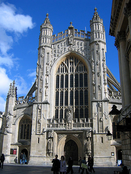
  1. The Abbey Church of Saint Peter and Saint Paul commonly known as Bath Abbey, is an Anglican parish church and a former Benedictine monastery. Founded in the 7th century, Bath Abbey was reorganised in the 10th century and rebuilt in the 12th and 16th centuries; major restoration work was carried out by Sir George Gilbert Scott in the 1860s. It is one of the largest examples of Perpendicular Gothic architecture in the West Country. The church is cruciform in plan, and is able to seat 1200. An active place of worship, with hundreds of congregation members and hundreds of thousands of visitors each year, it is used for religious services, secular civic ceremonies, concerts and lectures. The choir performs in the abbey and elsewhere. There is a heritage museum in the vaults. The abbey is a Grade I listed building, particularly noted for its fan vaulting. It contains war memorials for the local population and monuments to several notable people, in the form of wall and floor plaques and commemorative stained glass. The church has two organs and a peal of ten bells. The west front includes sculptures of angels climbing to heaven on two stone ladders.
  2. The Royal Crescent is a street of 30 terraced houses laid out in a sweeping crescent. Designed by the architect John Wood the Younger and built between 1767 and 1774, it is among the greatest examples of Georgian architecture to be found in the United Kingdom and is a Grade I listed building. Although some changes have been made to the various interiors over the years, the Georgian stone façade remains much as it was when it was first built. Many notable people have either lived or stayed in the Royal Crescent since it was first built over 250 years ago, and some are commemorated on special plaques attached to the relevant buildings.
  3. Pulteney Bridge is a bridge that crosses the River Avon, in Bath. It was completed in 1773 and is designated by English Heritage as a grade I listed building. The bridge was designed by Robert Adam, whose working drawings are preserved in the Sir John Soane's Museum, and is one of only four bridges in the world with shops across the full span on both sides. Shops on the bridge include a flower shop, antique map shop, and juice bar.It is named after Frances Pulteney, heiress in 1767 of the Bathwick estate across the river from Bath. Bathwick was a simple village in a rural setting, but Frances's husband William could see its potential. He made plans to create a new town, which would become a suburb to the historic city of Bath. First he needed a better river crossing than the existing ferry, hence the bridge.
  4. The Victoria Art Gallery is free public art museum. The building was designed in 1897 by John McKean Brydon, and has been designated as a Grade II listed building. The exterior of the building includes a statue of Queen Victoria, by A. C. Lucchesi, and friezes of classical figures by G. A. Lawson. The Gallery was named to celebrate Queen Victoria's sixty years on the throne. It is run by Bath and North East Somerset council and houses their collection of paintings, sculpture and decorative arts. It includes over 1,500 decorative arts treasures including a display of British oil paintings from 17th century to the present day including works by Thomas Gainsborough, Thomas Jones Barker and Walter Sickert.
  5. The Roman Baths complex The house is a well-preserved Roman site for public bathing. The Roman Baths themselves are below the modern street level. There are four main features: the Sacred Spring, the Roman Temple, the Roman Bath House and the Museum holding finds from Roman Bath. The buildings above street level date from the 19th century. The Baths are a major tourist attraction and, together with the Grand Pump Room, receive more than one million visitors a year. It was featured on the 2005 TV program Seven Natural Wonders as one of the wonders of the West Country. Visitors can see the Baths and Museum but cannot enter the water. An audio guide is available in several languages. 


Chester

Chester


Chester is a city in Cheshire, England. Lying on the River Dee, close to the border with Wales, it is the largest and most populous settlement of the wider unitary authority area of Cheshire West and Chester. Chester was granted city status in 1541.

The Romans founded Chester as Deva Victrix in the 70s AD in the land of the Celtic Cornovii, according to ancient cartographer Ptolemy, as a fortress during the Roman expansion northward. It was named Deva either after the goddess of the Dee, or directly from the British name for the river. The 'victrix' part of the name was taken from the title of the Legio XX Valeria Victrix which was based at Deva. A civilian settlement grew around the military base, probably originating from trade with the fortress. The fortress was 20% larger than other fortresses in Britannia built around the same time at York (Eboracum) and Caerleon (Isca Augusta); this has led to the suggestion that the fortress, rather than London (Londinium), was intended to become the capital of the Roman province of Britannia Superior. 

The civilian amphitheatre, which was built in the 1st century, could seat between 8,000 and 10,000 people. It is the largest known military amphitheatre in Britain, and is also a Scheduled Monument. The Minerva Shrine in the Roman quarry is the only rock cut Roman shrine still in situ in Britain. The fortress was garrisoned by the legion until at least the late 4th century. Although the army had abandoned the fortress by 410 when the Romans retreated from Britannia, the Romano-British civilian settlement continued (probably with some Roman veterans staying behind with their wives and children) and its occupants probably continued to use the fortress and its defences as protection from raiders from the Irish Sea.

Chester was captured from the Britons by the Kingdom of Northumbria after the brutal and decisive Battle of Chester in the early 7th century. Deverdoeu was still one of two Welsh language names for Chester in the late 12th century; its other and more enduring Welsh name was Caerlleon, literally "the fortress-city of the legions", a name identical with that of the Roman fortress at the other end of the Welsh Marches at Caerleon in Monmouthshire, namely Isca Augusta. The modern Welsh name is the shortened form, Caer. 

The early Old English speaking Anglo Saxon settlers used a name which had the same meaning, Legacæstir, which was current until the 11th century, when, in a further parallel with Welsh usage, the first element fell out of use and the simplex name Chester emerged. From the 14th century to the 18th century the city's prominent position in North West England meant that it was commonly also known as Westchester. This name was used by Celia Fiennes when she visited the city in 1698.

Chester played a significant part in the Industrial Revolution which began in the North West of England in the latter part of the 18th century. The city village of Newtown, located north east of the city and bounded by the Shropshire Union Canal was at the very heart of this industry. The large Chester Cattle Market and the two Chester railway stations, Chester General and Chester Northgate Station, meant that Newtown with its cattle market and canal, and Hoole with its railways were responsible for providing the vast majority of workers and in turn, the vast amount of Chester's wealth production throughout the Industrial Revolution.

A considerable amount of land in Chester is owned by the Duke of Westminster who owns an estate, Eaton Hall, near the village of Eccleston. He also has London properties in Mayfair.

Grosvenor is the Duke's family name, which explains such features in the City such as the Grosvenor Bridge, the Grosvenor Hotel, and Grosvenor Park. Much of Chester's architecture dates from the Victorian era, many of the buildings being modelled on the Jacobean half-timbered style and designed by John Douglas, who was employed by the Duke as his principal architect. He had a trademark of twisted chimney stacks, many of which can be seen on the buildings in the city centre.

Douglas designed amongst other buildings the Grosvenor Hotel and the City Baths. In 1911, Douglas' protégé and city architect James Strong designed the then active fire station on the west side of Northgate Street. Another feature of all buildings belonging to the estate of Westminster is the 'Grey Diamonds' – a weaving pattern of grey bricks in the red brickwork laid out in a diamond formation.

Towards the end of World War II, a lack of affordable housing meant many problems for Chester. Large areas of farmland on the outskirts of the city were developed as residential areas in the 1950s and early 1960s producing, for instance, the suburb of Blacon. In 1964, a bypass was built through and around the town centre to combat traffic congestion.

These new developments caused local concern as the physicality and therefore the feel of the city was being dramatically altered. In 1968, a report by Donald Insall in collaboration with authorities and government recommended that historic buildings be preserved in Chester. Consequently, the buildings were used in new and different ways instead of being flattened.


In 1969 the City Conservation Area was designated. Over the next 20 years the emphasis was placed on saving historic buildings, such as The Falcon Inn, Dutch Houses and Kings Buildings.

On 13 January 2002, Chester was granted Fairtrade City status. This status was renewed by the Fairtrade Foundation on 20 August 2003.

Chester has fantastic shopping for its size. All the major stores are based in one of the most attractive city centres in the country. Traditional black and white Tudor buildings and The Rows coupled with good shops and great places to eat, such as The Watergates Wine Bar, are sure to make this a pleasant shopping trip.

The Grosvenor Shopping Centre offers a stylish and cosmopolitan way of shopping. The wide range of retailers serve all your shopping needs, whether it be health and beauty, fashion or homeware items, jewellery or food. From Laura Ashley and Futon Company to well known high street clothing retailers including River Island and La Senza, there is something for everyone all under one roof. Costa Coffee is on hand for when you want to relax with friends and have a bite to eat in between your shopping, if you fancy Italian we have Piccolinos or for a treat try Millies Cookies or Sweets from Heaven.


                                                        Chester’s Top 5:
       
  1. Chester Cathedral is the mother church of the Church of England Diocese of Chester. The cathedral, formerly St Werburgh's abbey church of a Benedictine monastery, is dedicated to Christ and the Blessed Virgin Mary. Since 1541 it has been the seat of the Bishop of Chester and centre of worship, administration, ceremony and music for the city and diocese. The cathedral is a Grade I listed building, and part of a heritage site that also includes the former monastic buildings to the north, also listed Grade I. The cathedral, typical of English cathedrals in having been modified many times, dates from between 1093 and the early 16th century, although the site itself may have been used for Christian worship since Roman times. All the major styles of English medieval architecture, from Norman to Perpendicular, are represented in the present building.
  2. The Eastgate Clock stands on the site of the original entrance to the Roman fortress of Deva Victrix. It is a prominent landmark in the city of Chester and is said to be the most photographed clock in England after Big Ben. The original gate was guarded by a timber tower which was replaced by a stone tower in the 2nd century, and this in turn was replaced probably in the 14th century. The present gateway dates from 1768 and is a three-arched sandstone structure which carries the walkway forming part of Chester city walls. In 1899 a clock was added to the top of the gateway to celebrate the diamond jubilee of Queen Victoria two years earlier. It is carried on openwork iron pylons, has a clock face on all four sides, and a copper ogee cupola. The clock was designed by the Chester architect John Douglas. The whole structure, gateway and clock, was listed by English Heritage on 28 July 1955 as a Grade I listed building.
  3. Chester Rows consist of covered walkways at the first floor behind which are entrances to shops and other premises. At street level is another set of shops and other premises, many of which are entered by going down a few steps. The Rows, found in each of the four main streets of the city, are unique; nothing precisely similar exists anywhere else in the world. Dating from the medieval era, the Rows may have been built on top of rubble remaining from the ruins of Roman buildings, but their origin is still subject to speculation. In some places the continuity of the Rows has been blocked by enclosure or by new buildings, but in others modern buildings have retained the Rows in their designs. Undercrofts or "crypts" were constructed beneath the buildings in the Rows. The undercrofts were in stone while most of the buildings in the Rows were in timber.
  4. Chester Town Hall is in Northgate Street in the centre of the city. In 1698 an Exchange was built to accommodate the city's administrators. This building burnt down in 1862. A competition was held to build a new town hall and this was won by William Henry Lynn of Belfast. The building cost £40,000 (£2,850,000 as of 2012). It was officially opened on 15 October 1869 by the Prince of Wales (the future Edward VII) who was accompanied by W. E. Gladstone, the Prime Minister. On 27 March 1897 the council chamber on the second floor was gutted by fire. It was restored by T. M. Lockwood the following year. In 1979 a clock was installed in the tower with three faces; there is no face on the west side of the tower.
  5. Chester city walls consist of a defensive structure built to protect the city. Their construction was started by the Romans when they established the fortress of Deva Victrix between 70 and 80 AD. It originated with a rampart of earth and turf surmounted by a wooden palisade. From about 100 AD they were reconstructed using sandstone, but were not completed until over 100 years later. Following the Roman occupation nothing is known about the condition of the walls until Æthelflæd refounded Chester as a burgh in 907. The defences were improved, although the precise nature of the improvement is not known. After the Norman conquest, the walls were extended to the west and the south to form a complete circuit of the medieval city. The circuit was probably complete by the middle of the 12th century.


Monday, 19 November 2012

Winchester

Winchester


Winchester (archaically known as Winton and Wintonceastre) is a historic cathedral city and former capital city of England. It is the county town of Hampshire, in Southern England. The city lies at the heart of the wider City of Winchester, a local government district, and is located at the western end of the South Downs, along the course of the River Itchen.


Settlement in the area dates back to prehistoric times, with three Iron Age hillforts, Oram's Arbour, St Catherine's Hill and Worthy Down all in the near vicinity. In the Late Iron Age a more urban settlement-type developed, known as an oppidum, although the archaeology of this phase remains obscure. After the Roman conquest of Britain, this town became the capital of the local tribe or civitas, known as the Belgae, a confederation of Gaulish tribes who conquered large parts of the southern Britain beginning around 100 BCE. The city was known as Venta Belgarum, which may mean "Market" or "Meeting-Place of the Belgae". Although in the early years of the Roman province it was of subsidiary importance to Silchester and Chichester, over time it came to eclipse them both.

At the beginning of the third century Winchester was given protective stone walls. At around this time the city covered an area of 144 acres (58 ha), making it the fifth largest town in Roman Britain by surface area. There was also a limited suburban area outside the walls. Like many other Roman towns however, Winchester began to decline in the later fourth century.

The city has historic importance as it replaced Dorchester-on-Thames as the de facto capital of the ancient kingdom of Wessex in about 686 after King Caedwalla of Wessex defeated King Atwald of Wight. Although it was not the only town to have been the capital, it was established by King Egbert as the main city in his kingdom in 827. Saint Swithun was Bishop of Winchester in the mid 9th century. It was sacked by the Danes in 860.

The Saxon street plan laid out by Alfred the Great is still evident today: a cross shaped street system which conformed to the standard town planning system of the day – overlaying the pre-existing Roman street plan (incorporating the ecclesiastical quarter in the south-east; the judicial quarter in the south-west; the tradesmen in the north-east). The town was part of a series of fortifications along the south coast. Built by Alfred to protect the Kingdom, they were known as 'burhs'. The medieval city walls, built on the old Roman walls, are visible in places. Only one section of the original Roman walls remains. Four main gates were positioned in the north, south, east and west plus the additional Durngate and King's Gate. Winchester remained the capital of Wessex, and then England, until some time after the Norman Conquest when the capital was moved to London. The Domesday Book was compiled in the city late in the reign of William the Conqueror, but did not cover the city itself.

A serious fire in the city in 1141 accelerated its decline. However, William of Wykeham (1320–1404) played an important role in the city's restoration. As Bishop of Winchester he was responsible for much of the current structure of the cathedral, and he founded the still extant public school Winchester College. During the Middle Ages, the city was an important centre of the wool trade, before going into a slow decline. The curfew bell in the bell tower, still sounds at 8.00pm each evening. The curfew was the time to extinguish all home fires until the morning.

The novelist Jane Austen died in Winchester on 18 July 1817 and is buried in the cathedral. The Romantic poet John Keats stayed in Winchester from mid-August to October 1819. It was in Winchester that Keats wrote "Isabella", "St. Agnes' Eve", "To Autumn" and "Lamia". Parts of "Hyperion" and the five-act poetic tragedy "Otho The Great" were also written in Winchester.

The Great Hall In Winchester Castle


                                                        Winchester’s Top 5:
       
  1. Winchester Cathedral, the longest cathedral in Europe, was originally built in 1079. It contains much fine architecture spanning the 11th to the 16th century and is the place of interment of numerous Bishops of Winchester (such as William of Wykeham), Anglo-Saxon monarchs (such as Egbert of Wessex) and later monarchs such as King Canute and William Rufus, as well as Jane Austen. It was once an important pilgrimage centre and housed the shrine of Saint Swithun. The ancient Pilgrims' Way travelling to Canterbury begins at Winchester. The plan of the earlier Old Minster is laid out in the grass adjoining the cathedral. The New Minster (original burial place of Alfred the Great and Edward the Elder) once stood beside it. It has a girls choir and a boys choir, which sing on a regular basis at the cathedral.
  2. Winchester Castle is a medieval building in Hampshire. It was founded in 1067. Only the Great Hall still stands; it houses a museum of the history of Winchester. Between 1222–1235, Henry III (who was born at Winchester Castle) added the Great Hall, built to a "double cube" design, measuring 110 ft by 55 ft by 55 ft (approx. 33.5m by 16.8m by 16.8m). The Great Hall is built of flint with stone dressings; originally it had lower walls and a roof with dormer windows. In their place were added the tall two-light windows with early plate tracery. Extensions to the castle were made by Edward II. In 1873 the roof of the Great Hall was completely replaced. An imitation Arthurian Round Table hangs in the Great Hall. The table was originally constructed in the 13th century, and repainted in its present form for Henry VIII; around the edge of the table are the names of King Arthur's knights. Behind the Great Hall is a re-creation of a medieval garden called Queen Eleanor's Garden.
  3. The Winchester City Mill is a restored water mill situated on the River Itchen in the centre of the ancient city. The mill is owned by the National Trust. The mill was first recorded, milling corn, in the Domesday Book of 1086. The mill was last rebuilt in 1744 and remained in use until the early 1900s. The mill was then used as a laundry until 1928 when it was offered for sale. In order to prevent its demolition, a group of benefactors bought the mill and presented it to the National Trust. In 1932 the mill was leased to the Youth Hostels Association for use as a hostel, a usage that continued until recently. In 2004, a 12 year restoration program came to a successful conclusion, and after a hiatus of at least 90 years the mill again milled flour by water power. The water mill can be seen working daily during the summer months. The mill building also houses a National Trust shop.
  4. The City Museum, located on the corner of Great Minster Street and The Square, contains much information on the history of Winchester. Early examples of Winchester measures of standard capacity are on display. The museum was one of the first purpose-built museums to be constructed outside of London. Local items featured include the Roman 'Venta' gallery, and some genuine period shop interiors taken from the nearby High Street.
  5. The Buttercross has been dated to the 15th century, and features 12 statues of the Virgin Mary, saints and various historical figures. Several statues appear to have been added throughout the structure's history. In 1770, Thomas Dummer purchased the Buttercross from the Corporation of Winchester, intending to have it re-erected at Cranbury Park, near Otterbourne. When his workmen arrived to dismantle the cross, they were prevented from doing so by the people of the city, who "organised a small riot" and they were forced to abandon their task. The agreement with the city was cancelled and Dummer erected a lath and plaster facsimile, which stood in the park for about sixty years before it was destroyed by the weather. The Buttercross itself was restored by G. G. Scott in 1865, and still stands in the High Street. It is now a Scheduled Ancient Monument.


Thursday, 2 August 2012

Portsmouth

Portsmouth


Portsmouth is the second largest city in the ceremonial county of Hampshire on the south coast of England. Portsmouth is notable for being the United Kingdom's only island city; it is located mainly on Portsea Island. It is situated 64 miles (103 km) south west from London and 19 miles (31 km) south east from Southampton.

As a significant naval port for centuries, Portsmouth is home to the world's oldest dry dock still in use and also home to some famous ships, including HMSWarrior, the Tudor carrack Mary Rose and Lord Nelson's flagship, HMS Victory. Although smaller than in its heyday, the naval base remains a major dockyard and base for the Royal Navy and Royal Marine Commandos whose Headquarters resides there. There is also a thriving commercial ferryport serving destinations on the continent for freight and passenger traffic.


There have been settlements in the area since before Roman times, mostly being offshoots of Portchester, which was a Roman base (Portus Adurni) and possible home port of the Classis Britannica. Portsmouth is commonly regarded as having been founded in 1180 by the Anglo-Norman lord Jean de Gisors. Most early records of Portsmouth are thought to have been destroyed by Norman invaders following the Norman Conquest. The earliest detailed references to Portsmouth can be found in the Southwick Cartularies. However, there are records of "Portesmūða" from the late 9th century, meaning "mouth of the Portus harbour". The Anglo-Saxon Chronicle entry for 501 claims that "Portesmuða" was founded by a Saxon warrior called Port, though historians do not accept that origin of the name. 

In the Domesday Book there is no mention of Portsmouth. However, settlements that were later to form part of Portsmouth are listed. At this time it is estimated the Portsmouth area had a population not greater than two or three hundred. Whereas Portsea had a small church prior to 1166, Portsmouth's first real church was built in 1181, when a chapel dedicated to Thomas Becket was erected by Augustinian monks; it was run by the monks of Southwick Priory until the Reformation. The modern Portsmouth Anglican Cathedral is built on the original location of the chapel.

In 1194 King Richard The Lionheart returned from being held captive in Austria, and set about summoning a fleet and an army to Portsmouth, which Richard had taken over from John of Gisors. On 2 May 1194 the King gave Portsmouth its first Royal Charter granting permission for the borough to hold a fifteen day annual "Free Market Fair", weekly markets, to set up a local court to deal with minor matters, and exemption from paying the annual tax, with the money instead used for local matters. King Richard later went on to build a number of houses and a hall in Portsmouth. The hall is thought to have been at the current location of the Clarence Barracks (the area was previously known as Kingshall Green). Some believe that the crescent and eight-point star found on the thirteenth century common seal of the borough was derived from the arms of William de Longchamp, Lord Chancellor to Richard I at the time of the granting of the charter but it is actually the granting by Richard of the arms of the defeated Isaac Komnenos of Cyprus (Isaac had held Richard's fiancee and sister captive; and he conquered Cyprus as a result, in the Third Crusade. His awarding of the arms could possibly reflect a significant involvement of Portsmouth soldiers, sailors or vessels in that operation.). The crescent and star, in gold on a blue shield, were subsequently recorded by the College of Arms as the coat of arms of the borough.

In 1200 King John reaffirmed the rights and privileges awarded by King Richard. King John's desire to invade Normandy resulted in the establishment of Portsmouth as a permanent naval base, and soon afterward construction began on the first docks, and the Hospital of St Nicholas, which performed its duties as an almshouse and hospice. During the thirteenth century Portsmouth was commonly used by Henry III and Edward I as a base for attacks against France.

By the fourteenth century commercial interests had grown considerably. Common imports included wool, grain, wheat, woad, wax and iron, however the port's largest trade was in wine from Bayonne and Bordeaux.

In 1338 a French fleet led by Nicholas Béhuchet raided Portsmouth, destroying much of the town, with only the local church and hospital surviving. Edward III gave the town exemption from national taxes to aid reconstruction. Only ten years after this devastation the town for the first time was struck by the Black Death. In order to prevent the regrowth of Portsmouth as a threat, the French again sacked the city in 1369, 1377 and 1380. Henry V built the first permanent fortifications of Portsmouth. In 1418 he ordered a wooden Round Tower be built at the mouth of the harbour, which was completed in 1426. Henry VII rebuilt the fortifications with stone, raised a square tower, and assisted Robert Brygandine and Sir Reginald Bray in the construction of the world's first dry dock. In 1527, with some of the money from the dissolution of the monasteries, Henry VIII built Southsea Castle and decreed that Portsmouth be home of the Royal Navy he founded. In 1545, he saw his vice-flagship Mary Rose founder off Southsea Castle, with a loss of about 500 lives, while going into action against the French fleet. Over the years, Portsmouth's fortifications were rebuilt and improved by successive monarchs.

During the English Civil War the arsenal at the Square Tower was surrendered by its royalist commander in return for safe passage out of the city for himself and the garrison. The City would become a major base for the Parliamentary Navy during the war. The father of the Royal Navy Robert Blake during the Commonwealth would use Portsmouth as his main base, during both the Anglo Dutch war and the Anglo Spanish war. He died within sight of the city after his final cruise off Cadiz.

On 13 May 1787 11 ships sailed from Portsmouth, to establish the first European colony in Australia; it also marked the beginning of prisoner transports to that continent. It is known today as the First Fleet in Australia.

Portsmouth has a long history of supporting the Royal Navy logistically, leading to its importance in the development of the Industrial Revolution. Marc Isambard Brunel, the father of famed Portsmouth engineer Isambard Kingdom Brunel, established in 1802 the world's first mass production line at the Portsmouth Block Mills, to mass produce pulley blocks for rigging on the Royal Navy's ships. At its height the Dockyard was the largest industrial site in the world.

Admiral Nelson left Portsmouth for the final time in 1805 to command the fleet that would defeat the larger Franco-Spanish fleet at Trafalgar. The Royal Navy's reliance on Portsmouth led to the city becoming the most fortified in Europe, with a network of forts (a subset of "Palmerston's Follies") encircling the city. From 1808 the Royal Navy's West Africa Squadron, who were tasked to stop the slave trade, operated out of Portsmouth.

In 1926 Portsmouth was granted city status, following a long campaign by the borough council. The application was made on the grounds that Portsmouth was the "first naval port of the kingdom".
During the Second World War, the city was bombed extensively destroying many houses and the Guildhall. 930 people died in the air raids on Portsmouth and nearly 3,000 others were injured. There were also many injuries and deaths in the dockyard and naval and military establishments. Its status as a major port was the key factor in the Luftwaffe's decision to bomb it so heavily. While most of the city has since been rebuilt, developers still occasionally find unexploded bombs around the area. Southsea beach and Portsmouth Harbour were vital military embarkation points for the D-Day landings on 6 June 1944. Southwick House, just to the north of Portsmouth, had been chosen as the headquarters for the Supreme Allied Commander, US General Dwight D. Eisenhower, during D-Day.

After the war, much of the city's housing stock was damaged and more was cleared in an attempt to improve the quality of housing. Those people affected by this were moved out from the centre of the city to new developments such as Paulsgrove and Leigh Park. Post-war redevelopment throughout the country was characterised by utilitarian and brutalist architecture, with Portsmouth's Tricorn Centre one of the most famous examples. More recently, a new wave of redevelopment has seen Tricorn's demolition, the renewal of derelict industrial sites, and construction of the Spinnaker Tower.

The city centre is the main shopping area in Portsmouth, mainly sited around the shopping streets Commercial Road, Edinburgh Road, Arundel Street, Crasswell Street and Charlotte Street. The City Centre is home to the Cascades Shopping Centre and major high street stores. To the north of the City Centre is the Victory Retail Park. Portsmouth and Southsea railway station (the city's central station) is located to the south of the city centre, close to the Guildhall and the Civic Offices. Just to the south of the Guildhall is Guildhall Walk, a street which is known for its bars and clubs, such as Walkabout, VBar, Pure, and Babylon (a club that only plays music from the 90s). Located in Edinburgh Road is the Portsmouth Roman Catholic cathedral and Victoria Park.

The most significant project is at the Northern Quarter, centred on the former Tricorn site, which will form a new regional shopping destination. The development will provide new shops, cafés and restaurants.


                                                        Portsmouth’s Top 5:
       
  1. The Cathedral Church of St Thomas of Canterbury commonly known as Portsmouth Cathedral, is the Church of England cathedral of the Diocese of Portsmouth and is located in the heart of Old Portsmouth. It is the seat of the Bishop of Portsmouth.  Around the year 1180, Jean de Gisors, a wealthy Norman merchant and Lord of the Manor of Titchfield, gave land, in his new town of Portsmouth, to the Augustiniancanons of Southwick Priory, so that they could build a chapel "to the Glorious Honour of the Martyr Thomas of Canterbury, one time Archbishop, on (my) land which is called Sudewede, the island of Portsea". This chapel was to become, in turn, a parish church in the 14th century and then a cathedral in the 20th century. Of this original building, the chancel and transepts remain.   
  2. HMS Victory is a 104-gun first-rate ship of the line of the Royal Navy, laid down in 1759 and launched in 1765. She is most famous as Lord Nelson's flagship at the Battle of Trafalgar in 1805. She was also Keppel's flagship at Ushant, Howe's flagship at Cape Spartel and Jervis's flagship at Cape St Vincent. After 1824 she served as a harbour ship. In 1922 she was moved to a dry dock at Portsmouth, and preserved as a museum ship. She continues to be flagship of the Second Sea Lord and is the oldest naval ship still in commissionThe naval architect chosen to design the ship was Sir Thomas Slade who, at the time, was the appointed Surveyor of the Navy. She was designed to carry at least 100 guns and was established with that number of guns; in practice, her armament varied from 104 to 106 guns and carronades. In January 1808 the Victory was reduced to a 98-gun second rate, but was reclassed as a 104-gun first rate in February 1817. The keel was laid on 23 July 1759 in the Old Single Dock (since renamed No. 2 Dock and now Victory Dock), and the name was finally chosen in October 1760.
  3. Southsea Castle (early in its history also known as Chaderton castle ) is one of Henry VIII's Device Forts, also known as Henrician Castles, built in 1544 on the waterfront at the southern end of Portsea Island (an area that later became named Southsea after the castle). The castle was built to guard the eastern entrance to the Solent and entrance to Portsmouth Harbour. Henry VIII watched the Mary Rose sink from near this location.  The Castle was initially constructed in 1544 however there is the possibility that work started the year before. The work was in part paid for by money received as part of the Dissolution of the Monasteries. The castle was constructed around a square keep. To the south towards the sea the castle had an angled bastion with the same arrangement on the north side. Square gun platforms made up the east and west sides. Edward VI spent a night at the castle in 1552 while inspecting the defenses of Portsmouth.
  4. Spinnaker Tower is a 170-metre (560 ft) landmark tower. It is the centrepiece of the redevelopment of Portsmouth Harbour, which was supported by a National Lottery grant. Its shape was chosen by Portsmouth residents from a selection. The tower, designed by local firm HGP Architects and the engineering consultants Scott Wilson and built by Mowlem, reflects Portsmouth's maritime history by being modelled after a sail. After several years of delays and cost overruns, it was opened on 18 October 2005.  The tower is 2 1⁄2 times as high as Nelson's Column, making it the tallest accessible structure in the United Kingdom outside London. The tower is visible for miles around Portsmouth, changing the horizon of the area. It can be seen from the Isle of Wight, and even the Manhood Peninsula.
  5. The Mary Rose was a carrack-type warship of the English Tudor navy of King Henry VIII. After serving for 33 years in several wars against France, Scotland, and Brittany and after being substantially rebuilt in 1536, she saw her last action on 19 July 1545. While leading the attack on the galleys of a French invasion fleet, she sank in the Solent, the straits north of the Isle of Wight. The wreck of the Mary Rose was rediscovered in 1971 and salvaged in 1982 by the Mary Rose Trust in one of the most complex and expensive projects in the history of maritime archaeology. The surviving section of the ship and thousands of recovered artefacts are of immeasurable value as a Tudor-era time capsule. The excavation and salvage of the Mary Rose was a milestone in the field of maritime archaeology, comparable in complexity and cost only to the raising of the Swedish 17th-century warship Vasa in 1961. The finds include weapons, sailing equipment, naval supplies and a wide array of objects used by the crew. Many of the artefacts are unique to the Mary Rose and have provided insights into topics ranging from naval warfare to the history of musical instruments. Since the mid-1980s, while undergoing conservation, the remains of the hull have been on display at the Portsmouth Historic Dockyard. An extensive collection of well-preserved artefacts is on display at the nearby Mary Rose Museum.