Translate

Showing posts with label Turkey. Show all posts

Saturday, 1 December 2012

Antalya

Antalya


Antalya is a city on the Mediterranean coast of southwestern Turkey. It was the world's third most visited city by number of international arrivals in 2011, displacing New York. It is Turkey's biggest international sea resort.

It is uncertain when the site of the current city was first inhabited. Attalos II, king of Pergamon, was believed to have founded the city around 150 BC, naming it Attaliaand selecting it as a naval base for his powerful fleet. However, excavations in 2008 in the Doğu Garajı district have uncovered remains dating to the 3rd century BC, suggesting that the city was founded earlier than previously supposed. Antalya became part of the Roman Republic in 133 BC when King Attalos III of Pergamon willed his kingdom to Rome at his death. The city grew and prospered during the Ancient Roman period.

Christianity started to spread in the region after 2nd century. Antalya was visited by Paul of Tarsus, as recorded in the Acts of the Apostles: "From Perga, Paul and Barnabas went down to Attalia and sailed from there to Antioch after preaching in Pisidia and Pamphylia".

Antalya was a major city in the Byzantine Empire. It was the capital of the Byzantine Theme of Carabisiani, which occupied the southern coasts of Anatolia and the Aegean Islands. At the time of the accession of John II Comnenus in 1118 it was an isolated outpost surrounded by Turkish beyliks, accessible only by sea.

The city and the surrounding region were conquered by the Seljuk Turks in the early 13th century. Antalya was the capital of the Turkish beylik of Teke (1321–1423) until its conquest by the Ottomans. 

The Arabic traveler Ibn Battuta, who visited the city in 1335-1340, noted:

From Alanya I went to Antaliya [Adalia], a most beautiful city. It covers an immense area, and though of vast bulk is one of the most attractive towns to be seen anywhere, besides being exceedingly populous and well laid out. Each section of the inhabitants lives in a separate quarter. The Christian merchants live in a quarter of the town known as the Mina [the Port], and are surrounded by a wall, the gates of which are shut upon them from without at night and during the Friday service. The Greeks, who were its former inhabitants, live by themselves in another quarter, the Jews in another, and the king and his court and Mamluks in another, each of these quarters being walled off likewise. The rest of the Muslims live in the main city. Round the whole town and all the quarters mentioned there is another great wall. The town contains orchards and produces fine fruits, including an admirable kind of apricot, called by them Qamar ad-Din, which has a sweet almond in its kernel. This fruit is dried and exported to Egypt, where it is regarded as a great luxury.

In the second half of the 17th century Evliya Çelebi wrote of a city of narrow streets containing 3,000 houses in 20 Turkish and four Greek neighborhoods. The town had grown beyond the city walls and the port was reported to hold up to 200 boats.

In the 19th century, in common with most of Anatolia, its sovereign was a "dere bey" (land lord or landowner). The family of Tekke Oğlu, domiciled near Perge had been reduced to submission in 1812 by Mahmud II, but continued to be a rival power to the Ottoman governor until within the present generation, surviving by many years the fall of the other great beys of Anatolia. The records of the Levant (Turkey) Company, which maintained an agency in Antalya until 1825, documented the local dere beys.

In the 20th century the population of Antalya increased as Turks from the Caucasus and the Balkans moved into Anatolia. By 1911 it was a city of about 25,000 people, including many Christians and Jews, still living in separate quarters around the walled mina or port. The economy was centered on its port that served the inland areas, particularly Konya. Antalya (then Adalia) was picturesque rather than modern. The chief attraction for visitors was the city wall, and outside a promenade, a portion of which survives. The government offices and the houses of the higher classes were outside the walls.

The city was occupied by the Italians from the end of the First World War until the founding of the Turkish Republic in 1923. Large-scale development beginning in the 1970s transformed Antalya from a pastoral town into one of Turkey's largest metropolitan areas. Much of this has been due to tourism, which expanded in the 21st century.

Kaleiçi, with its narrow cobbled streets of historic Ottoman era houses, is the old centre of Antalya. With its hotels, bars, clubs, restaurants, and shopping, it has been restored to retain much of its historical character; its restoration has won the Golden Apple Tourism Prize. Cumhuriyet Square, the main square of the city, is the location for temporary open air exhibitions and performances. The city also features sites with traces of Lycian, Pamphylian, and Hellenistic, Roman, Byzantine, Seljuk and Ottoman architecture and cultures. International luxury hotels stand along the coast above the Konyaalti and Lara beaches.


                                                        Antalya’s Top 5:
       
  1. Yivli Minare Camii (Fluted Minaret Mosque), is a historical mosque in Antalya. It is part of a külliye (complex of structures) which includes the Gıyaseddin Keyhüsrev Medrese, Seljuk and Dervish lodge, and the vaults of Zincirkıran and Nigar Hatun. The mosque is located in Kaleiçi (the old town centre) along Cumhuriyet Caddesi, next to Kalekapısı Meydanı. The mosque's fluted minaret called the Yivli Minare, which is decorated with dark blue tiles, is a landmark and symbol of the city. The mosque was first built in 1230 and fully reconstructed for the second time in 1373. The minaret is 38 metres (125 ft) high, built on a square stone base, with eight fluted sections and has 90 steps to the top.
  2. Konyaaltı Beach (Konyaaltı Plaji) is one of the two main beaches of Antalya, the other being Lara Beach. The beach is located on the western side of the city and stretches for 7 km from the cliffs to the Beydağları mountains. It is bound inwards by the beach park and numerous bars, cafes, nightclubs and hotels, including the Rixos Downtown Hotel (formerly the Sheraton Voyager Hotel). The 'Aqualand' waterpark along Dumlupınar Bulvarı is the other border.
  3. The Antalya Museum or Antalya Archeological Museum is one of Turkey's largest museums, located in Konyaaltı. It includes 13 exhibition halls and an open air gallery. It covers an area of 7,000 m2 (75,000 sq ft) and has 5000 works of art are exhibited. In addition a further 25,000–30,000 artifacts which cannot be displayed are in storage. As a museum exhibiting examples of works, which illuminate the history of the Mediterranean and Pamphylia regions in Anatolia, Antalya Museum is one of the most important of Turkey's museums. The Museum won the “European Council Special Prize” in 1988.
  4. Düden Waterfalls are a group of waterfalls, formed by the Düden River (one of the major rivers in southern Anatolia), located 12 kilometres (7.5 mi) north-east of Antalya. They end where the waters of the Lower Düden Falls drop off a rocky cliff directly into the Mediterranean Sea.
  5. The Hadrian's Gate, or Hadrianus Gate is a triumphal arch which was built in the name of the Roman emperor Hadrian, who visited Antalya in the year 130. It has three arched gates. According to the legend, Sultan Belkis, the Queen of Sheba, is said to have passed under those gates and enjoyed a happy day in the palace in Aspendos on her way to visit King Solomon. Formerly the city walls enclosed the outside of the gate and it was not used for many years. This may be the reason why it has not been harmed, and it was only revealed when the walls collapsed. It is considered as Pamphylia's most beautiful Gate. The upper part has three apertures in the shape of a cupola, and except for the pillars is built entirely of white marble. The ornamentation is very striking. The original Gate was two storeys but little is known of the top storey. On either side of the Gate are towers, which are known not to have been built at the same time. The southern one is known as the Julia Sancta tower and is a work of the Hadrian era. It was constructed of plain stone blocks. While the base of the northern tower belongs to antiquity, the upper part is left over from the Seljuk period.


Tuesday, 12 June 2012

Nicosia

Nicosia


Nicosia, known locally as Lefkosia, is the capital and largest city in Cyprus, as well as its main business center. After the collapse of the Berlin Wall, Nicosia remained the only divided capital in the world, with the southern and the northern portions divided by a Green Line. It is located near the center of the island, on the banks of the Pedieos River.

Nicosia is the capital and seat of government of the Republic of Cyprus. The northern part of the city functions as the capital of the self-proclaimed Turkish Republic of Northern Cyprus, a disputed breakaway region whose independence is recognized only by Turkey, and which the rest of the international community considers as occupied territory of the Republic of Cyprus since the Turkish Invasion in 1974.

Nicosia has been in continuous habitation since the beginning of the Bronze Age 2500 years BC, when the first inhabitants settled in the fertile plain of Mesaoria. Nicosia later became a city-state known as Ledra or Ledrae, one of the twelve kingdoms of ancient Cyprus built by Achaeans after the end of the Trojan War. Remains of old Ledra today can be found in the Ayia Paraskevi hill in the south east of the city. We only know about one king of Ledra, Onasagoras. The kingdom of Ledra was destroyed early. Under Assyrian rule of Cyprus, Onasagoras, was recorded as paying tribute to Esarhaddon of Assyria in 672 BC. Rebuilt by Lefkonas, son of Ptolemy I around 300 BC, Ledra is described as a small and unimportant town, also known as Lefkotheon. The main activity of the town inhabitants was farming. During this era, Ledra did not have the huge growth that the other Cypriot coastal towns had, which was primarily based on trade.


In Byzantine times the town was also referred to as Lefkousia and also as Kallinikisis. In the 4th century AD, the town became the seat of bishopship, with bishop Saint Tryphillius (Trifillios), a student of Saint Spyridon.

After the destruction of Salamis by Arab raids in 647, the existing capital of Cyprus, Nicosia became the capital of the island around 965, when Cyprus rejoined the Byzantine Empire. The Byzantines moved the islands administration seat to Nicosia, primarily for security reasons as coastal towns were often suffering from raids. Since then it remains as the capital of Cyprus. Nicosia had acquired a castle and was the seat of the Byzantine governor of Cyprus. The last Byzantine governor of the Island was Isaac Comnenus who declared himself emperor of the island and ruled the island from 1183–1191.


Selimiye Mosque
On his way to the Holy Land during the Third Crusade in 1187, Richard I of England fleet was plagued by storms. He himself stopped first at Crete and then at Rhodes. Three ships continued on, one of which was carrying Queen Joan of Sicily and Berengaria of Navarre, Richard's bride-to-be. Two of the ships were wrecked off Cyprus, but the ship bearing Joan and Berengaria made it safely to Limassol. Joan refused to come ashore, fearing she would be captured and held hostage by Isaac Comnenus, who hated all Franks. Her ship sat at anchor for a full week before Richard finally arrived on the 8th of May. Outraged at the treatment of his sister and his future bride, Richard invaded.

Richard laid siege to Nicosia. Richard finally met and defeated Isaac Comnenus at Tremetousia. Richard became ruler of the island but sold the island to the Knights Templar. The Knights Templar ruled the island having bought it from Richard the Lionheart for 100.000 gold byzantiums. Their seat was the castle of Nicosia. On Easter day on the 11th of April 1192 the people of Nicosia revolted and drove the Knights Templar off the city. Having driven the Knights Templar away, fearing their return the Nicosians demolished the castle of the city almost to its foundations.

Guy of Lusignan, King of Jerusalem, bought Cyprus from the Knights Templar and brought many noble men and other adventurers, from France, Jerusalem, Tripoli, the Principality of Antioch and Kingdom of Armenia, to the island. The Frankish rule of Cyprus started from 1192 and lasted until 1489. During this time, Nicosia was the capital of the medieval Kingdom of Cyprus, the seat of Lusignan kings, the Latin Church and the Frankish administration of the island. During the Frankish rule, the walls of the city were built along with many other palaces and buildings, including the gothic Saint Sofia Cathedral. The tombs of the Lusignan kings can be found there. 

In 1489 Cyprus was captured by the Republic of Venice. Nicosia was their administrative centre and the seat of the Venetian Governor. Since the threat from the Ottomans was visible, the Venetian Governors of Nicosia emphasized in their letters the need for all the cities of Cyprus to be fortified. In 1567 Venetians built the new fortifications of Nicosia, which are well-preserved until today, demolishing the old walls built by the Franks as well as other important buildings of the Frankish era including the King's Palace, other private palaces and churches and monasteries of both Orthodox and Latin Christians. The new walls took the shape of a star with eleven bastions. The design of the bastion is more suitable for artillery and a better control for the defenders. The river Pedieos used to flow through the Venetian walled city. In 1567 it was later diverted outside onto the newly built moat for strategic reasons, due to the expected Ottoman attack. 

On July 1 st 1570 the Ottomans invaded the island. On the 22nd of July, Piale Pasha having captured Paphos, Limassol and Larnaca marched his army towards Nicosia and laid siege to the city. The city managed to last 40 days under siege until its fall on 9 September 1570. Some 20,000 residents died during the sige and every church, public building, and palace was looted. After its siege it was reported that the walls that were ruined, Nicosia retained very few inhabitants. The main Latin churches were converted into mosques, such as the conversion of Saint Sofia Cathedral into the Selimiye Mosque. From 1570 when the Ottomans took over Nicosia, the old river bed through the walled city was left open and was used as a dumping ground for refuse, where rainwater would rush through clearing it temporarily.

The House of Hadjigeorgakis Kornessios
At the time of British administration, Nicosia was still contained entirely within its Venetian walls. Although full of private gardens and amply supplied with water carried to public fountains in aqueducts, the streets remained unpaved and just wide enough for a loaded pack animal. In 1881, macadamized roads through the town were completed to connect with the main roads to the coastal towns but no roads were asphalted until after World War I. On 5 July 1878 the administration of the island was officially transferred to Great Britain. On 31 July 1878, Garnet Wolseley, the first High Commissioner, arrived in Nicosia. He immediately established a skeletal administration by sending officers to each district to supervise the administration of justice and obtain all possible information about the area. Garnet Wolseley immediately established a Post Office at his camp at Kykko Metochi monastery outside Nicosia. Garnet Wolseley lived at ‘Monastery Camp' until a prefabricated residence had been built for him near Strovolos on the site of today's Presidential Palace.

In 1955 an armed struggle against the British rule began aiming to unite the island with Greece, Enosis. The struggle was led by EOKA, a Greek Cypriot nationalist military resistance organisation, and supported by the vast majority of Greek Cypriots. The unification with Greece failed and instead the independence of Cyprus was declared in 1960. During the period of the struggle, Nicosia was the scene of violent protests against the British rule.

In 1960 Nicosia became the capital of the Republic of Cyprus, whose constitution was based on the co-operation of the island's two main communities, Greek and Turkish Cypriots. In December 1963, during the aftermath of a constitutional crisis, skirmishes broke out between Greek Cypriots and the Turkish Cypriots. Nicosia was divided into Greek and Turkish Cypriot quarters. The dividing line, which cuts through the city, was named Green line because the pen used by the United Nations officer to draw the line on a city map was green.

On the 15th July 1974, there was an attempted coup d'état led by the Greek military junta to unite the island with Greece. The coup ousted president Makarios III and replaced him with pro-enosis nationalist Nikos Sampson.

On the 20th July 1974, the Turkish army invaded the island on the pretext of restoring the constitutional order of the Republic of Cyprus. However, even after the restoration of constitutional order and the return of Archbishop Makarios III to Cyprus in December 1974, the Turkish troops remained on the island occupying the northeastern portion of the island. The invasion was given the codename Operation Attila and included two phases.

The second phase of the Turkish invasion was performed on the 14th August 1974, where the Turkish army advanced their positions, eventually capturing a total of 37% of Cypriot territory including the northern part of Nicosia and the cities of Kyrenia and Famagusta. The fighting left the island with a massive refugee problem. Out of a population of 600,000, an estimated 200,000 Greek-Cypriots had been uprooted and forced to flee south of the Attila line, while an estimated 60,000 Turkish-Cypriots remained south of the Attila line, uncertain of their fate.

On February 13, 1975 the Turkish Cypriot community declared the Turkish Federated State of Cyprus in the area occupied by Turkish forces. On November 15, 1983, Turkish Cypriots proclaimed their independence as the Turkish Republic of Northern Cyprus.

Makarios III
The Turkish invasion, the continuous occupation of Cyprus as well as the self-declaration of independence of the TRNC have been condemned by several United Nations Resolutions adopted by the General Assembly and the Security Council. The Security Council is reaffirming their condemnation every year.

Despite the division Nicosia has managed to become a sophisticated and cosmopolitan city, rich in history and culture that combines its historic past with the amenities of a modern city.

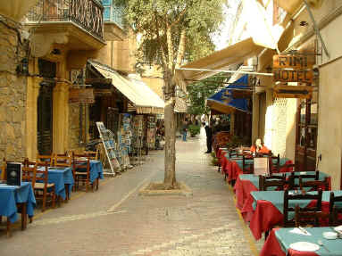
Without a doubt, the 1000 year old capital should be on every visitor's agenda. It lies roughly in the centre of the island, within easy reach of the other towns. A day in Nicosia will be a day well spent. To walk through the old city is to step backwards in time. Narrow streets and old houses with ornate balconies jut from weather beaten sandstone walls, and craftsmen in small workshops practice trades unchanged for centuries.

Apart from the unique places of interest left from the ancient times with memories of many generations, the present Nicosia is a dynamic metropolitan city with highly developed infrastructure and an attractive modern look. The uniqueness of such combination makes the capital of Cyprus a place worth knowing and certainly a place worth visiting.


The traditional shopping district runs along Ledra street and its tributary roads within the medieval walls of the city. A bustle of traditional jewelers, shoe and fabric shops give a blend of Middle Eastern and European feel.Laiki Geitonia is a pedestrianised neighbourhood that has been preserved in its original architecture and is the best quarter if you are after souvenir shops. Big chains (e.g. Marks and Spencer, Zara etc) line the more modern Makariou Avenue. Stasikratous street has evolved into a mini local version of 5th Avenue/Bond street with expensive brands such as Armani and Versace stores. All the above are within walking distance of each other.

There are no real department stores in a purist sense, but Ermes (this chain inherited and re-branded the old local Woolworths) has several mini department stores across the island and a couple on Makarios Avenue. Alpha-Mega and Orphanides are local hypermarket chains (worthy equivalent of a Tesco or Wal-Mart) where it would be difficult not to find what you were after. Most of their stores however, are located in the suburbs.

Ledra Street
Traditional Cypriot cuisine is a melting pot of south European, Balkan and Middle Eastern influences. You will find most Greek, Turkish and Arabic dishes, often with a local name or twist. It is now decades since Cyprus has established itself as a tourist hotspot and as a consequence many of the local chefs have trained in Europe and elsewhere, bringing their experiences back home with them. As such most international cuisines are well represented (but unfortunately so are McDonalds & gang). In summary good food is not difficult to come by and most westerners will find dining quite affordable.

The shopping district is dotted with local tavernas and the likes of KFC and Pizza Hut. Virtually all restaurants allow smoking, (and unfortunately some don't even have a non-smoking area, and most restaurants with the non-smoking area don't enforce it). Al fresco dining is a luxury that can be enjoyed for over half the year. It would be a crime not to try (at least once) a mixed pork kebab with a chilled local KEO or Carlsberg (which is brewed locally and tastes different to the same brand overseas) beer. Carnivores are spoilt for choice, whilst vegetarians might find it a tad difficult.

The food is high quality and somewhat cheaper than in the most Western capitals. Snacks should be available from €2-4, kebabs from €7 and whole meals from €15-20. Local KEO beer costs around €4 a pint in bars, local wines starting from €10 a bottle. Hygienic standards are followed and even foods that usually are not recommended in the Mediterranean destinations, such as mayonnaise and salad-based foods, can be safely eaten.

The substantial student population supports a flourishing industry of bars, pubs and nightclubs which keep the old city alive. Cypriots are true socialites and spend most of their time out as opposed to at home. In line with other south European countries going out is unheard of before 10-11pm. There is no official nightlife reference point but Makarios avenue turns into a catwalk cum cruising strip for Porsche owner show-offs. If you are after a more traditional flavour (generally catering for an older population) you could try a bouzouki bar.

Bars will stock the usual international brands of spirits. Local giants KEO beer and Carlsberg (the only other brand brewed on the island) have a universal presence. Local wines are now making a comeback after years of medioaracy and decline. Commandaria is the pride of Cyprus' dessert wines. The local spirit zivania (very similar to grappa) is usually drank as shots straight from the freezer. Cyprus brandy was introduced about 150 years ago and differs from other continental brandies in its lower alcohol content (around 32%). As such it is is often drank by locals whilst eating (and before and after) and is the basic ingredient for a local cocktail, The Brandy Sour. Local Ouzo is also another favourite.

Coffee culture is a way of life in Nicosia. It is the place to see and be seen in the afternoon to early evening. In the summer months, tables spill on to the streets. The posh cafes line Makarios avenue, intertwined with shops. Starbucks and Costa coffee have invaded the island but local equivalents also survive. For a change don't stick to the latte/capuccino, try a greek coffee. In the summer you must order a frappe (iced coffee).


                                                        Nicosia’s Top 5:
       
  1. Ayios Ioannis Cathedral. Is within the Archbishopric, Arch. Kyprianos Square. built by Archbishop Nikiforos in 1662, the recently restored 18th century wall paintings depict biblical scenes and the discovery of the tomb of Saint Barnabas at Salamis. Dedicated to Ayios loannis (Saint John). The archbishopric is the centre of the Cyprus Orthodox Church, the new Archbishopric built in a neo-byzantine style in 1960, contains the private suite of the late Archbishop Makarios. Open to the public only on special occasions.
  2. Selimiye Mosque or Agia Sofia Cathedral, formerly Cathédrale Sainte Sophie, is located in the Turkish controlled northern part of the walled city of Nicosia. It is the main mosque in the city. Possibly constructed on the site of an earlier Byzantine church. The building belongs to the pure Gothic style of the beginning of the 12th century. Due to the building’s large scale, lack of money and various historical events it took 150 years for the cathedral to be built and still, it was never entirely completed since the southwest tower and the portico’s upper floor were never constructed. The cathedral’s first construction phase began during the first years of Frankish rule (possibly in 1209) and already by 1228 the eastern part of the building was completed. By the end of the 13th century the side aisles and a large part of the middle aisle were completed. From 1319 to 1326 the Latin archbishop Giovanni del Conte or Giovanni de Polo was responsible for the completion of the middle aisle, the construction of the roof buttresses, the cathedral’s façade and the building of a chapel (which functioned as a baptistery) in the western part of the southern wall. He also adorned parts of the cathedral with frescoes and sculptures. In November 1326 the cathedral’s official inauguration took place.
  3. The Venetian City Walls. This fortification complex has a circumference of 3 miles, and contains eleven pentagon-shaped bastions named after eleven families, pillars of the Italian aristocracy of the town, who donated funds towards the construction of the walls and the three gates, Porta San Domenico Paphos Gate, Porta Guiliana -Famagusta Gate, and Porta del Proveditore -Kyrenia Gate-. Experts contemporary to the construction of the walls have considered them as a prime example of 16th century military architecture. Their design incorporates specific innovative techniques, marking the beginning of a renaissance era in fortification construction. These include the positioning of gates to the side of the adjoining bastions, so they could be more easily protected in times of siege, and leaving the upper half of the wall unlined with masonry, so as to increase its ability to absorb the impact from cannon shot.
  4. Cyprus Museum. This museum was established to collect, study and display archaeological artifacts from all over the island. Some of the exhibits are as old as 8,500 years. The museum is arranged in chronological order. The first hall contains pottery and implements from the Neolithic and Chalcolithic periods whilst the other rooms trace the history of Cyprus through the ages from the Bronze Age, Hellenic Period, Mycenaean times, and Roman Period to the earlyByzantine. A unique feature of the museum lies in the basement, where several graves rest in a dark cellar complete with skeletal remains and grave adornments that have been reconstructed.
  5. The House of Hadjigeorgakis Kornessios. Originally a Venetian Building. It is probably the most important 18th century building in Nicosia. It was once the house of the Dragoman Hadjigeorgakis Kornessios. The house is being restored and will house the Cyprus Ethnographic Museum. Hadjigeorgakis Kornessios house has won the Europa Nostra award in 1988.


    Venetian City Walls


Thursday, 26 April 2012

Izmir

Izmir


Izmir is a large metropolis in the western extremity of Anatolia in Turkey. Izmir metropolitan area extends along the outlying waters of the Gulf of İzmir and inland to the north across Gediz River's delta, to the east along an alluvial plain created by several small streams and to a slightly more rugged terrain in the south. The ancient city was known as Smyrna, and the city was generally referred to as Smyrna in English, until the Turkish Postal Services Law of 1930 made "Izmir" the internationally recognized name.

The city is one of the oldest settlements of the Mediterranean basin. The 2004 discovery of Yeşilova Höyük and the neighboring Yassıtepe, situated in the small delta of Meles River, now the plain of Bornova, reset the starting date of the city's past further back than was previously thought. The findings of the two seasons of excavations carried out in the Yeşilova Höyük indicate three levels, two of which are prehistoric. Level 2 bears traces of early to mid-Chalcolithic, and Level 3 of Neolithic settlements. These two levels would have been inhabited by the indigenous peoples of İzmir, very roughly, between 7th millennium BC to 4th millennium BC. With the seashore drawing away in time, the site was later used as a cemetery. Several graves containing artifacts dating, roughly, from 3000 BC, contemporary with the first city of Troy, were found. 


İzmir's remarkable growth began in the late 16th century when cotton and other products of the region attracted French, English, Dutch and Venetian traders here. With the privileged trading conditions accorded to foreigners in 1620, İzmir set out on its way to become one of the foremost trade centers of the Empire. Foreign consulates moved in from Sakız (Chios) and were present in the city by the early 17th century (1619 for the French Consulate, 1621 for the British), serving as trade centers for their nations. Each consulate had its own quay and the ships under their flag would anchor there. The long campaign for the conquest of Crete (22 years between 1648–1669) also considerably enhanced İzmir's position within the Ottoman realm since the city served as a port of dispatch and supply for the troops.

The city faced a plague in 1676, an earthquake in 1688 and a great fire in 1743, but continued to grow. By the end of the 17th century, its population was estimated at around ninety thousand, the Turks forming the majority (about 60,000), while there were also 15,000 Greeks, 8,000 Armenians and 6 to 7,000 Jews, as well as a considerable segment composed of French, English, Dutch and Italian merchants. In the meantime, the Ottomans had allowed İzmir's inner bay dominated by the port castle to silt up progressively (the location of the present-day Kemeraltı bazaar zone) and the port castle ceased to be of use.


Modern day Izmir is an interesting mixture of modern High rise buildings with wide tree lined boulevards. There are still many traditional houses and chateaus hidden away to discover though. Izmir enjoys a temperate climate with mild winters and warm summers, which is probably why the street life is so lively. 

A walk on the Kordon reveals an endless line of bistros, bars, restaurants, coffee shops and tea houses all spilling onto the street. In many cases so close together it is often difficult to know exactly which place you are actually relaxing in.

Turkish cuisine which has inherited the Ottoman heritage could be described as a fusion and refinement of Turkic, Arabic, Greek, Armenian and Persian cuisines. Ottomans fused various culinary traditions of their realm with influences from Middle Eastern cuisines, along with traditional Turkic elements from Central Asia such as yogurt. The Ottoman Empire indeed created a vast array of technical specialities. It can be observed that various regions of the Ottoman Empire contain bits and pieces of the vast Ottoman dishes.

Kadifekale
İzmir's cuisine has largely been affected by its multicultural history, hence the large variety of food originating from the Aegean, Mediterranean and Anatolian regions. Another factor is the large area of land surrounding the region which grows a rich selection of vegetables. Some of the common dishes found here are tarhana soup (made from dried yoghurt and tomatoes), İzmir köfte, keşkek (boiled wheat with meat), zerde (sweetened rice with saffron) and mücver (made from zucchini and eggs). Historically, as a result of the influx of Greek refugees from İzmir (as well as from other parts of Asia Minor and Istanbul) to mainland Greece after 1922, the cuisine of İzmir has had an enormous impact on Greek cuisine, exporting many sophisticated spices and foods.

The Culture Park in the Alsancak district hosts the annual Izmir International fair, held every year in September. The rest of the year many other fairs and expos take place also. In addition to serving the commercial needs of the city the Culture Park provides a relaxing green area in the middle of the city for the residents to lay back, drink tea play backgammon and smoke a "hubbly bubbly pipe" (Nargile) or even exercise on the running track.

Kemeralti

                                                        Izmir’s Top 5:
       
  1. İzmir Clock Tower  is located at the Konak Square in Konak district of İzmir. The clock tower was designed by the Levantine French architect Raymond Charles Père and built in 1901 to commemorate the 25th anniversary of Abdülhamid II's (reigned 1876–1909) accession to the throne. The clock itself was a gift of German Emperor Wilhelm II (reigned 1888–1918). It is decorated in an elaborate Ottoman architecture. The tower, at a height of 25 m (82 ft), features four fountains, which are placed around the base in a circular pattern, and the columns are inspired by North African themes. The clock tower was depicted on the reverse of the Turkish 500 lira banknotes of 1983-1989
  2. Kemeralti.  A visit to Izmir can not be complete without spending a few hours wandering round the Market Area of Kemeralti. This is a bustling bazaar where literally anything can be purchased. It is a confusing warren of small allies, dead ends, connecting squares, shopping centers, offices, workshops, cinemas, Mosques and just about anything else you can think of, there is even a renovated Karavan Sarai hidden in there. You are pretty much guaranteed to lose your way, but don't panic you will find your way out eventually.
  3. Kadifekale (literally "the velvet castle" in Turkish) is the name of the hill located within the urban zone of İzmir, as well as being the name of the ancient castle on top of the same hill. Both the hill and the castle were named Pagos (Pagus under the Roman Empire) in pre-Turkish times. The summit where the castle is found is located at a distance of about 2 km from the shoreline and commands a general view of a large part of the city of İzmir, as well as of the Gulf of İzmir. Administratively, the hill area covers six quarters constituted by slums in their large part, one named Kadifekale like the hill, and others Alireis, Altay, İmariye, Kosova and Yenimahalle. In 2007, the metropolitan municipality of İzmir started renovation and restoration works in Kadifekale.
  4. Agora Open Air Museum (Old Smyrna) The ancient city is located at two sites within modern İzmir. The first site, probably founded indigenously, rose to prominence during the Archaic Period as one of the principal ancient Greek settlements in western Anatolia. The second, whose foundation is associated with Alexander the Great, reached metropolitan proportions during the period of the Roman Empire. Most of the present-day remains date from the Roman era, the majority from after a 2nd century AD earthquake. In practical terms, a distinction is often made between Old Smyrna, the initial settlement founded around the 11th century BC, first as an Aeolian settlement, and later taken over and developed during the Archaic Period by the Ionians, and Smyrna proper, the new city moved into from the older one as of the 4th century BC and whose foundation was inspired, and perhaps also initiated, by Alexander the Great.
  5. The İnciraltı Sea Museum is a naval museum in the İnciraltı neighborhood of Izmir's Balçova district. Located near the İnciraltı Ozdilek Shopping Center, it was opened on July 1, 2007. Main attractions of the museum are two decommissioned naval vessels of the Turkish Navy, the submarine TCG Pirireis (S 343) (the former USS Tang (SS-563)) and the frigate TCG Ege (F 256)(the former USS Ainsworth (FF-1090)). There are also other exhibits at the museum.

Agora

References: http://www.izmir.com/


Friday, 6 April 2012

Fethiye

Fethiye


Fethiye is a city and district of Muğla Province in the Aegean region of Turkey. Modern Fethiye is located on the site of the ancient city of Telmessos, the ruins of which can be seen throughout the city. Telmessos was the most important city of Lycia, with a recorded history starting in the 5th century BC.  The Lycians were never members of a specific country, but rather a tightly-knit confederation of fiercely independent city-states.

The city became part of the Persian Empire after the invasion of the Persian King Harpagos in 547 BC, along with other Lycian and Carian cities. Telmessos then joined the Attic-Delos Union established in mid-5th century BC. and, although it later left the union and became an independent city, continued its relations with the union until the 4th century BC.


Legend says that Alexander the Great, on a mission to invade Anatolia in the winter of 334–333 BC, entered Telmessos harbour with his fleet. The commander of the fleet, Nearchus, asks permission of King Antipatrides of Telmessos for his musicians and slaves to enter the city. On getting the permission, the warriors with weapons hidden in the flute boxes capture the acropolis during the feasts held at night.

Fethiye was formerly known as Makri; while it received a considerable amount of Turkish population from the Greek Islands and mainland Greece under the terms of the 1923 exchange of populations between Greece and Turkey, the Greeks deported from the area founded the town of Nea Makri (New Makri) in Greece.
In 1934, the city was renamed 'Fethiye' in honor of Fethi Bey, one of the first pilots of the Ottoman Air Force, killed on an early mission.


Roman Theatre

Fethiye is a treasure of the Turkish coast. You will most definitely receive a warm welcome in Fethiye. The town has grown from a modest trading port/fishing village and fertile tomato growing area to a rapidly expanding vibrant town and tourist holiday destination which offers many things to many people, from those with an interest in history and nature to those looking for sun, sea and great food.

The centre of modern day Fethiye shows great variation in very short distances. The Lycian Rock tombs carved into the rock sides over 2,000 years ago, the old Paspatur area (the narrow lanes of shops and restaurants, once used to store the delivered cargoes from the arriving ships) sits shoulder to shoulder with the “new town” - new in the aftermath of the devastating earthquake of 1956 anyway - and both run seamlessly into the marina area sitting beneath the more recently added and exceptionally desirable residential area of Karagozler, where everyone seems to have a sea view - continue further round the bay and next is the 20,000m2 private peninsula of the popular Club Letoonia resort, an all inclusive style holiday hotel (more of a village than a hotel in truth) and within 5 minutes drive we have seen over two centuries years of development and progress.


There cannot be another place on the planet where the phrase "something for every budget" is more true. Dining out is an experience and with different budgets the experience may be different, but all so very enjoyable. Restaurants can cost you anything from a couple of pounds upwards. Forget rotating stumps of meat-like substance on the way home from a large quantity of lagers, Turkish Kebab Houses offer fresh, flavoursome doners and kebabs served in diverse ways from across the country. Chicken doners contain just chicken, lamb is 100% lamb meat, nothing in the way of fillers or strange offcuts. With the amazing local naturally organic vegetables which taste fabulous, you can enjoy a filling lunch for a couple of pounds. 

Paspatur
Local lokanta restaurants offer wholesome, filling and very tasty prepared meals. There is normally a great range to choose from and they are all such good value that it is possible to choose two or three main dishes and see if you like them. The different meals and side dishes are normally displayed from behind a glass food cabinet. Remember these restaurants are not touristic, they are providing the working man with much required sustenance - so it could well be that no English is spoken. No problem though, they will be happy to serve you exactly what you point at through the glass! Again, the local vegetables make wonderful side dishes (and surprisingly often main courses too).


Recently recommended in their Top 15 'on the up' destinations, Tripadvisor write "Prepare to be enchanted by this lively Mediterranean seaside town and working harbour. Travellers report it's less touristy than other nearby towns, though with shops, restaurants, and fascinating ruins all around, there's plenty to see and do. Hike to nearby Kayaköy, an abandoned "ghost village," or visit the magnificent beach at Ölüdeniz, where you can bask in the sun or paraglide over the turquoise waters". 

Fethiye's canalside market


                                                        Fethiye’s Top 5:
       
  1. The Tomb of Amyntas, also known as the Fethiye Tomb is an ancient tomb located in the south side of the city in the mountainside, in the base of the mountain. The impressive looking tomb was built in 350 BC, and was named after the Greek inscription on the side of it which reads "Amyntou tou Ermagioiu", which translated to English means "Armyntas, son of Hermagious". The tomb was built by the Lycians, the people who lived in this area of Turkey at the time. What makes this tomb unique is the fact that it is very large inside. While many other tombs carved into mountainsides are quite little, comparable to a small room, the interior of the Tomb of Amyntas is the size of a full-sized temple.
  2. Fethiye Castle.  The ancient castle stands on the place where the city was first founded. Its existing walls date back from the eleventh century. Rebuilt during the fifteenth century by the Knights of Rhodes, the castle was used as a naval base. The incredible views of Fethiye from the hill make up for the lack of general upkeep of the castle ruins and the short walk up the hill. At sunset there is no better place to enjoy a few drinks and watch quietly, as the city is bathed in a golden glow, the sky turns pink, outlining the islands lying in the bay and eventually the sparkle of the city lights below.
  3. The Roman Theatre. Built in the second century AD, the Roman Theatre stands opposite the commercial harbour near the town centre. Typically Roman in style, it was built on the ruins of a previously built Greek style theatre. Excavated in 1993, the theatre is undergoing a restoration project.
  4. Fethiye Market.  Tuesday is a busy day in Fethiye town. Its market day and the town is bustling with hundreds of stallholders situated either side of the canal selling everything you can possibly think of.  Superb local grown fruit and veg at very low prices together with Turkish "Versace", Turkish "Gucci" clothes. Buy fake watches "Breitling", "Tag Huer", "Rado", "Rolex" etc. They look identical to the real thing and are usually avaiable in two grades. The first is a cheap version from £10 to £25 and are usually quite heavy, the second quality sometimes waterproof, vary from £25 to £80. Please shop around however and haggle.
  5. Ölüdeniz Beach (literally Dead Sea) is a small resort village in the Fethiye district with the Aegean Sea to the south and the high, steep sided Babadağ Mountain to the North, 14 km (9 mi) south of Fethiye. The town is a beach resort. Ölüdeniz remains one of the most photographed beaches on the Mediterranean. It has a secluded sandy bay at the mouth of Ölüdeniz, on a blue lagoon. The beach itself is a pebble beach. The lagoon is a national nature reserve and building is strictly prohibited. Ölüdeniz is famous for its shades of turquoise and aquamarine, and is an official blue flag beach, and is frequently rated among the top 5 beaches in the world by travelers and tourism journals alike. The resort is also famous for its paragliding opportunities. It is regarded as one of the best places in the world to paraglide due to its unique panoramic views, and the Babadağ Mountain's exceptional height.


    Ölüdeniz Blue Lagoon


Tuesday, 21 February 2012

Ankara

Ankara


Ankara is the capital of Turkey and the country's second largest city after Istanbul. Centrally located in Anatolia, Ankara is an important commercial and industrial city. It is the centre of the Turkish Government, and houses all foreign embassies. It is an important crossroads of trade, strategically located at the centre of Turkey's highway and railway networks, and serves as the marketing centre for the surrounding agricultural area. Ankara is a very old city with various Hittite, Phrygian, Hellenistic, Roman, Byzantine, and Ottoman archaeological sites. The hill which overlooks the city is crowned by the ruins of the old castle, which adds to the picturesqueness of the view, but only a few historic structures surrounding the old citadel have survived to the present day. 
The oldest settlements in and around the city centre of Ankara belonged to the Hatti's civilization which existed during the Bronze Age. The city grew significantly in size and importance under the Phrygians starting around 1000 BC, and experienced a large expansion following the mass migration from Gordion, (the capital of Phrygia), after an earthquake which severely damaged that city around that time. In Phrygian tradition, King Midas was venerated as the founder of Ancyra, but Pausanias mentions that the city was actually far older, which accords with present archaeological knowledge.


After Ankara became the capital of the newly founded Republic of Turkey, new development divided the city into an old section, called Ulus, and a new section, called Yenişehir. Ancient buildings reflecting Roman, Byzantine, and Ottoman history and narrow winding streets mark the old section. The new section, now centered on Kızılay, has the trappings of a more modern city: wide streets, hotels, theaters, shopping malls, and high-rises.


Historically, the production of Mohair from the Angora goat; and Angora wool from the Angora rabbit; have been an important part of the city's economy. These fabrics have been exported from Ankara to Europe and other parts of the globe for centuries.

The Central Anatolia Region is one of the primary locations of grape and wine production in Turkey, and Ankara is particularly famous for its Kalecik Karası and Muscat grapes; and its Kavaklıdere wine, which is produced in the Kavaklıdere neighbourhood within the Çankaya district of the city. 


Atakule Observation Tower


Walking up the hill to the citadel gate, you find many interesting shops selling spices, dried fruits, nuts, and all kinds of produce; the selection is huge and very fresh. Modern shopping areas are mostly found in Kızılay, on Tunalı Hilmi Avenue, including the modern mall of Karum. Foreign visitors to Ankara usually like to visit the old shops in Çıkrıkçılar Yokuşu near Ulus, where myriad things ranging from traditional fabrics, hand-woven carpets and leather products can be found at bargain prices. Bakırcılar Çarşısı (Bazaar of Coppersmiths) is particularly popular, and many interesting items, not just of copper, can be found here like jewelry, carpets, costumes, antiques and embroidery. 


Anıtkabir


                                                                             Ankara’s Top 5:
Temple of Augustus and Rome
       
  1. Ankara Citadel. The foundations of the citadel or castle were laid by the Galatians on a prominent lava outcrop and the rest was completed by the Romans. The Byzantines and Seljuqs further made restorations and additions. The area around and inside the citadel, being the oldest part of Ankara, contains many fine examples of traditional architecture. There are also recreational areas to relax. Many restored traditional Turkish houses inside the citadel area have found new life as restaurants, serving local cuisine. The citadel was depicted in various Turkish banknotes during 1927–1952 and 1983–1989
  2. Temple of Augustus and Rome. The temple, also known as the Monumentum Ancyranum, was built between 25 BC - 20 BC following the conquest of Central Anatolia by the Roman Empire and the formation of the Roman province of Galatia, with Ancyra (modern Ankara) as its administrative capital. After the death of Augustus in 14 AD, a copy of the text of Res Gestae Divi Augusti was inscribed on the interior of the pronaos in Latin, whereas a Greek translation is also present on an exterior wall of the cella. The temple, on the ancient Acropolis of Ancyra, was enlarged by the Romans in the 2nd century. In the 5th century it was converted into a church by the Byzantines. It is located in the Ulus quarter of the city.
  3. Atakule. is a 125m (410 feet) high communications and observation tower located in the Çankaya district and is one of the primary landmarks of the city. As the district of Çankaya is itself on a hill, the tower can be spotted from almost anywhere in the city during clear days. The tower's design came from architect Ragıp Buluç and construction lasted from 1987 to 1989. The top section of the tower houses an open terrace and a revolving restaurant named Sevilla, which makes a full 360 degree rotation in one hour. On top of Sevilla is another restaurant, Dome, which is non-revolving and located directly under the cupola. Under the terrace is a café, named UFO. The bottom structures house a shopping mall and several indoor and outdoor restaurants.
  4. Anıtkabir.  Located on an imposing hill, in the Anıttepe quarter of the city, is where the mausoleum of Mustafa Kemal Atatürk, founder of the Republic of Turkey, stands. Completed in 1953, it is an impressive fusion of ancient and modern architectural styles. An adjacent museum houses a wax statue of Atatürk, his writings, letters and personal items, as well as an exhibition of photographs recording important moments in his life and during the establishment of the Republic
  5. Kocatepe Mosque, the largest mosque in the city. Located in the Kocatepe quarter, it was constructed between 1967 and 1987 in classical Ottoman style with four minarets. Its size and prominent location have made it a landmark for the city.